You also want an ePaper? Increase the reach of your titles
YUMPU automatically turns print PDFs into web optimized ePapers that Google loves.
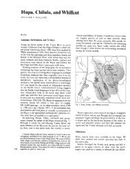
~~ ~~ ~~~~~~~ ~~~~~~ ~~ -~ ~ ~~~ ~~~11On August 12, 1864, at Fort Gaston, Wiley negotiated an agreementwith the Hoopa Indians along the Trinity River entitled“Treaty of peace and friendship between the United States governmentand the Hoopa, South Fork, Redwood, and Grouse Creek Indians.”.Section 1 of the agreement provided that-The United States * * * by these presents doth agree andobligate itself to set aside for reservation purposes for thesole use and benefit of the tribes of Indians herein named,or such tribes as may hereafter avail themselves of thebenefit of this treaty, the whole of Hoopa valley, to be heldand used for the sole benefit of the Indians whose namesare hereunto affixed as the representatives of their tribes.Section 2 provided that the reservation “shall include a sufficientarea of mountain on each side of the Trinity River as shall be necessaryfor hunting grounds, gathering berries, seeds, etc.” Thisagreement or “treaty” was never submitted for ratification.On August 21, 1864, at Fort Gaston, California, SuperintendentWiley issued a proclamation, under the authority of the 1864 Actand instructions from the Interior Department, establishing theHoopa Valley Reservation on the Trinity River in Klamath County,California. Wiley’s proclamation provided that the metes andbounds of the reservations would be established later by order ofthe Interior Department, subject to the approval of the President.The Trinity River in the Hoopa Valley flows north through thevalley to the junction of the Trinity and Klamath Rivers. Since thereservation was described as extending six miles on each side ofthe river to the junction of the two rivers, the reservation formed a12-mile square bisected by the last 12 miles of the Trinity River,and has come to be called the “Square” or the “12-mile Square”.As of February 18, 1865, when Wiley defined the boundaries of theHoopa Valley Reservation, there have been identified, among thevarious tribes resident there, a substantial number of Indians ofthe Hoopa Tribe living in several villages in the Hoopa Valleyproper, a smaller group of Lower Klamath or Yurok Indians livingin a few villages in the northern and northwestern part of the reservation,and a number of Indians of the Redwood or Chilula tribe.On June 23, 1876, President Grant issued an executive order formallyestablishing the boundaries of the Hoopa Valley Reservationand provided that the land embraced therein “be, and hereby is,withdrawn from public sale, and set apart in California by act ofCongress approved April 8, 1864.” As bounded, the reservation wasa square, twelve miles on a side, encompassing approximately88,665.52 acres.The Court of Claims in the Jessie Short case found that, at aboutthe time of the 1876 Executive Order, there had been identified asliving within the boundaries of the reservation established the followingtribes:Tribe:Hoopas ............................................................................................ ............................... 511........................................................................ 434656-~511441213