Climate Change and Water Management in South Florida
Climate Change and Water Management in South Florida
Climate Change and Water Management in South Florida

Create successful ePaper yourself
Turn your PDF publications into a flip-book with our unique Google optimized e-Paper software.
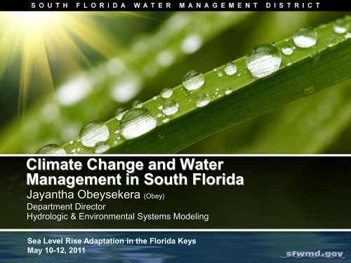
<strong>Climate</strong> <strong>Change</strong> <strong>and</strong> <strong>Water</strong><strong>Management</strong> <strong>in</strong> <strong>South</strong> <strong>Florida</strong>Jayantha Obeysekera (Obey)Department DirectorHydrologic & Environmental Systems Model<strong>in</strong>gSea Level Rise Adaptation <strong>in</strong> the <strong>Florida</strong> KeysMay 10-12, 2011
Potential <strong>Climate</strong> <strong>Change</strong> Impacts toSFWMD<strong>Climate</strong> <strong>Change</strong> DriversNatural CyclesInterannual(e.g. El N<strong>in</strong>o <strong>and</strong> LaN<strong>in</strong>a) toMulti-decadal(e.g. AMO*)Human InducedL<strong>and</strong> use changesGreenhouse gases->Global Warm<strong>in</strong>gQuartet of change:Stressors•Ris<strong>in</strong>g Seas•Temperature•Ra<strong>in</strong>fall, floods,<strong>and</strong> droughts•Tropical Storms &Hurricanes<strong>Water</strong> <strong>Management</strong>Impacts•Direct l<strong>and</strong>scapeimpacts (e.g. stormsurge)•<strong>Water</strong> Supply(e.g. droughts,saltwater <strong>in</strong>trusion)• Flood Control(e.g. urban flood<strong>in</strong>g,hurricanes)•Natural Systems(e.g. ecosystemimpacts, bothcoastal <strong>and</strong> <strong>in</strong>terior)*Atlantic Multi-decadal Oscillation of temperature <strong>in</strong> the Atlantic Ocean
SFWMD White Paper, Technical Paper &Strategy• Two Important Questions:• Which decisions are likely tobe affected <strong>and</strong> could benefitfrom adaptation strategies(Type I) <strong>in</strong> the short term?‣“No Regret Strategies”• Which decisions are likely tobe affected but for whichadaptation strategies (TypeII) could be deferred withoutserious consequences?
Future Projections of Sea Level Rise:Polar Ice Uncerta<strong>in</strong>tyGreenl<strong>and</strong>(~ 2 million sq.km.)Antarctica(~5.4 million sq. km.)
Sea Level Rise relative to 2010 (mm)0 500 1000 1500 2000What is the future rate of acceleration?GlobalKey WestRapid acceleration dueto ice sheet lossMedium accelerationCont<strong>in</strong>u<strong>in</strong>g current trend1950 2000 2050 2100Year
FSUSea Level R ise (<strong>in</strong>.)70605060.0Plann<strong>in</strong>g Horizon (~2060)High RangeCGMFSUCGMCGMIPCCCGMBrowardUNEP (2009)5 feet4 feet•Resilience•Adaptive Capacity•“no regret strategies”•Adaptive <strong>Management</strong>•Alternative Futures•Cont<strong>in</strong>gency Plans79.04030203 feet2 feet19.22030.0NRC31.5Low Range1001 footNRC10.84.82.452030 2050 2080 2100Year8.47.0
Are we see<strong>in</strong>g more of these?<strong>Florida</strong> Keys(Monroe Co)7Photo Credit: The Nature Conservancy
Impacts of Ris<strong>in</strong>g Seas:Flood ControlCoastal StructureOcean Side(tailwater)L<strong>and</strong> Side(headwater)
VulnerableStructuresPrelim<strong>in</strong>ary reviewbased on orig<strong>in</strong>aldesigns28 gravitystructures on theEast CoastSix gravitystructures on thewest coastMost vulnerablestructures are <strong>in</strong>Miami-Dade <strong>and</strong>Broward countiesPrioritized 3structuresS-29S-28S-27
Potential Impact of Ris<strong>in</strong>g Seas:<strong>South</strong>ern Everglades• Relocation <strong>and</strong> possiblereduction of mangroveforests• Forced migration of wad<strong>in</strong>gbirds northward• Potential peat collapse,coastal erosion, <strong>and</strong>redistribution of sediments• Sal<strong>in</strong>ity <strong>in</strong>trusion <strong>in</strong>tofreshwater marshes can:discharge toxic hydrogensulfide, cause coastal fishkills, <strong>and</strong> <strong>in</strong>crease habitatloss
Ris<strong>in</strong>g Seas - <strong>Water</strong> Supply:Saltwater Intrusion
Saltwater - Groundwater Interface• Review groundwater monitor<strong>in</strong>gnetwork used to develop themap of the saltwatergroundwater<strong>in</strong>terface• Identify gaps• Identify utilities at riskLake WorthLantana
<strong>Water</strong> Supply <strong>and</strong> <strong>Water</strong> Conservation• Cont<strong>in</strong>ue look<strong>in</strong>g at opportunities <strong>and</strong>technologies to reduce amount ofadditional freshwater needed for watersupply• Look at opportunities touse reuse as a hydraulicbarrier• Implement waterconservation measures• Develop alternativewater supply options
Flood Inundation Tools – DigitalElevation Maps (DEM) Project• Improved support foroperations <strong>and</strong> projects• Hydrologic <strong>and</strong> hydraulicmodels• Sea-level rise, storm surge,dike-failure study• Ecological studies – plantcommunities vs. l<strong>and</strong>scapeposition, black-mangrovedie-off areas, etc.• Identify historical features –river channels, logg<strong>in</strong>gtrams, shell midden sites
• Flood ProtectionModel Development• Work<strong>in</strong>g with the Hydrologic Eng<strong>in</strong>eer<strong>in</strong>g Centerof the U.S. Army Corps of Eng<strong>in</strong>eers to develop asurface water/groundwater model. Currently themodel is be<strong>in</strong>g tested <strong>in</strong> the C-4 Bas<strong>in</strong>• <strong>Water</strong> Supply• USACE, DOI <strong>and</strong> SFWMD collaborat<strong>in</strong>g on thedevelopment of saltwater <strong>in</strong>trusion models for thecoastal belt.• West coast model under development by our BigCypress Bas<strong>in</strong> office
Questions!Recent cab<strong>in</strong>et meet<strong>in</strong>g of the isl<strong>and</strong> nation, Maldives
Estimated Timeframes for 1 to 3 ft SLRbased on USACE SLR Projection for SE FL RegionProjected Sea Level Estimated Time OccurrenceRise1 foot 2040 - 20702 feet 2060 - 21153 feet 2078 - 215019Table Credit:A Unified Sea Level Rise Projection for <strong>South</strong>east <strong>Florida</strong> (<strong>in</strong> review). April 2011. Table 5.