Surface and Precipitation Stations - New Mexico Environment ...
Surface and Precipitation Stations - New Mexico Environment ...
Surface and Precipitation Stations - New Mexico Environment ...

You also want an ePaper? Increase the reach of your titles
YUMPU automatically turns print PDFs into web optimized ePapers that Google loves.
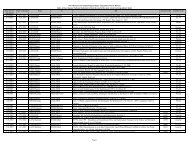
CALMET Control File Inputs<br />
Variable Description PNM Value Agreement<br />
with Default<br />
Comments<br />
INPUT GROUP 0: Input <strong>and</strong> Output<br />
NUSTA Number of Upper air<br />
stations<br />
10 n/a<br />
NOWSTA Number of over water met<br />
stations<br />
0 n/a Not using over water met stations<br />
INPUT GROUP 1: General Run Control Parameters<br />
IBYR Starting year of the<br />
2001 n/a 2002 <strong>and</strong> 2003 are the other years<br />
CALPUFF run<br />
modeled<br />
IBMO Starting month 1 n/a<br />
IBDY Starting day 1 n/a<br />
IBHR Starting hour 0 n/a<br />
IBTZ Base time zone 7 n/a Mountain St<strong>and</strong>ard Time<br />
IRLG Length of run (hours) 744 n/a CALMET run in daily increments<br />
31 days = 744 hours<br />
30 days = 720 hours<br />
28 days = 672 hours<br />
IRTYPE Run Type 1 Y Must be 1 to run CALPUFF<br />
LCALGRD Compute variables used by T Y Compute all fields required by<br />
both CALGRID <strong>and</strong><br />
CALPUFF<br />
CALPUFF<br />
ITEST Stop run after SETUP to do<br />
input QA<br />
2 Y<br />
INPUT GROUP 2: Map Projection <strong>and</strong> Grid Control Parameters<br />
PMAP Map Projection LCC UTM<br />
FEAST False Easting at the<br />
projection origin<br />
0.00 Y<br />
FNORTH False Northing at the<br />
projection origin<br />
0.00 Y<br />
IUTMZN UTM zone n/a n/a<br />
UTMHEM Hemisphere for UTM<br />
projection<br />
Latitude (dec. degrees) of<br />
n/a n/a<br />
RLATO projection origin<br />
40.0 N<br />
n/a<br />
RLONO Longitude (dec. degrees) of<br />
projection origin<br />
97.0 W n/a<br />
XLAT1 Matching parallel(s) of<br />
latitude projection<br />
33.0 N n/a<br />
XLAT2 Matching parallel(s) of<br />
latitude projection<br />
45.0 N n/a<br />
DATUM Datum region for output<br />
coordinates<br />
NWS-84 n/a<br />
NX Number of X grid cells in<br />
meteorological grid<br />
216 n/a<br />
NY Number of Y grid cells in<br />
meteorological grid<br />
216 n/a<br />
DGRIDKM Grid spacing, km 4 n/a Refined grid spacing<br />
XORIGKM Ref. Coordinate of SW<br />
corner of grid cell (1,1)<br />
-1368 n/a<br />
YORIGKM Ref. Coordinate of SW<br />
corner of grid cell (1,1)<br />
-900 n/a<br />
NZ No. of vertical layers 10 n/a<br />
B-1 4/13/2007