Surface and Precipitation Stations - New Mexico Environment ...
Surface and Precipitation Stations - New Mexico Environment ...
Surface and Precipitation Stations - New Mexico Environment ...

Create successful ePaper yourself
Turn your PDF publications into a flip-book with our unique Google optimized e-Paper software.
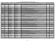
CALMET Control File Inputs<br />
Variable Description PNM Value Agreement<br />
with Default<br />
Comments<br />
surface stations 114 stations for 2003<br />
NPSTA Number of precipitation<br />
112 n/a 111 stations for 2002<br />
stations<br />
114 stations for 2003<br />
ICLOUD Gridded cloud fields 0 N<br />
IFORMS Formatted surface<br />
meteorological data file<br />
2 Y<br />
IFORMP Formatted surface<br />
precipitation data file<br />
2 Y<br />
IFORMC Formatted cloud data file 2 Y No additional cloud data used in<br />
the model.<br />
INPUT GROUP 5: Windfield Options <strong>and</strong> Parameters<br />
IWFCOD Model selection variable 1 Y<br />
IFRADJ Compute Froude number<br />
adjustment factor<br />
1 Y<br />
IKINE Compute kinematic effects 0 Y WRAP BART Modeling Protocol<br />
Recommended Value<br />
IOBR Use O’Brien (1970)<br />
vertical velocity adjustment<br />
0 Y<br />
ISLOPE Compute slope flow effects 1 Y<br />
IEXTRP Extrapolate surface wind<br />
1 N WRAP BART Modeling Protocol<br />
obs to upper level<br />
Recommended Value<br />
ICALM Extrapolate surface winds<br />
if calm<br />
0 Y<br />
BIAS Layer dependent biases<br />
weighting aloft<br />
measurements<br />
NZ*0 Y<br />
RMIN2 Minimum vertical<br />
extrapolation distance<br />
4 Y<br />
IPROG Use gridded prognostic<br />
14 N Use winds from MM5.DAT file as<br />
wind field model output<br />
fields as input to the<br />
diagnostic wind field model<br />
initial guess field<br />
ISTEPPG MM5 output timestep 1 Y<br />
LVARY Use varying radius of<br />
influence<br />
F Y<br />
RMAX1 Maximum radius of<br />
influence over l<strong>and</strong> in sfc<br />
layer<br />
50 n/a<br />
RMAX2 Maximum radius of<br />
influence over l<strong>and</strong> aloft<br />
100 n/a<br />
RMAX3 Maximum radius of<br />
100 n/a WRAP BART Modeling Protocol<br />
influence over water<br />
Recommended Value<br />
RMIN Minimum radius of<br />
influence used anywhere<br />
0.1 Y<br />
TERRAD Terrain feature radius of<br />
influence<br />
10 n/a<br />
R1 Weighting of first guess<br />
surface field<br />
100 n/a<br />
R2 Weighting of first guess<br />
aloft field<br />
200 n/a<br />
RPROG MM4 windfield weighting<br />
0 n/a Not used since IPROG is not equal<br />
parameter<br />
to 1.<br />
B-3 4/13/2007