A Study of the Source Mechanism of the Alaska Earthquake and ...
A Study of the Source Mechanism of the Alaska Earthquake and ...
A Study of the Source Mechanism of the Alaska Earthquake and ...

You also want an ePaper? Increase the reach of your titles
YUMPU automatically turns print PDFs into web optimized ePapers that Google loves.
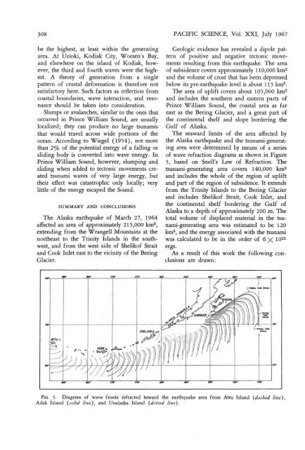
308 PACIFIC SCIENCE, Vol. XXI, July 1967be <strong>the</strong> highest, at least within <strong>the</strong> generatingarea. At Uzinki, Kodiak City, W omen's Bay,<strong>and</strong> elsewhere on <strong>the</strong> isl<strong>and</strong> <strong>of</strong> Kodiak, however,<strong>the</strong> third <strong>and</strong> fourth waves were <strong>the</strong> highest.A <strong>the</strong>ory <strong>of</strong> generation from a singlepattern <strong>of</strong> crustal deformation is <strong>the</strong>refore notsatisfactory here. Such factors as reflection fromcoastal boundaries , wave interaction, <strong>and</strong> resonanceshould be taken into consideration.Slumps or avalanches, similar to <strong>the</strong> ones thatoccurred in Prince William Sound , are usuallylocalized; <strong>the</strong>y can produce no large tsunamisthat would travel across wide portions <strong>of</strong> <strong>the</strong>ocean. According to Wiegel (195 4), not morethan 2% <strong>of</strong> <strong>the</strong> potential energy <strong>of</strong> a fallin g orsliding body is converted into wave energy. InPrince William Sound, however, slumping <strong>and</strong>sliding when added to tectonic movements createdtsunami waves <strong>of</strong> very large energy, but<strong>the</strong>ir effect was catastrophic only locally; verylittle <strong>of</strong> <strong>the</strong> energy escaped <strong>the</strong> Sound .SUMMARY AND CONCLUSIONSThe <strong>Alaska</strong> earthquake <strong>of</strong> March 27, 1964affected an area <strong>of</strong> approximately 215,000 krn-,extending from <strong>the</strong> W rangell Mountains at <strong>the</strong>nor<strong>the</strong>ast to <strong>the</strong> Trinity Isl<strong>and</strong>s in <strong>the</strong> southwest,<strong>and</strong> from <strong>the</strong> west side <strong>of</strong> Shelik<strong>of</strong> Strait<strong>and</strong> Cook Inlet east to <strong>the</strong> vicinity <strong>of</strong> <strong>the</strong> BeringGlacier.....'110"Geologic evidence has revealed a dipole pattern<strong>of</strong> positive <strong>and</strong> negative tectonic movementsresulting from this earthquake. The area<strong>of</strong> subsidence covers approximately 110,000 km 2<strong>and</strong> <strong>the</strong> volume <strong>of</strong> crust that has been depressedbelow its pre-earthquake level is about 115 km".The area <strong>of</strong> uplift covers about 105,000 km 2<strong>and</strong> includes <strong>the</strong> sou<strong>the</strong>rn <strong>and</strong> eastern parts <strong>of</strong>Prince William Sound, <strong>the</strong> coastal area as fareast as <strong>the</strong> Bering Glacier, <strong>and</strong> a great part <strong>of</strong><strong>the</strong> continental shelf <strong>and</strong> slope bordering <strong>the</strong>Gulf <strong>of</strong> <strong>Alaska</strong>.The seaward limits <strong>of</strong> <strong>the</strong> area affected by<strong>the</strong> <strong>Alaska</strong> earthquake <strong>and</strong> <strong>the</strong> tsunami-generatingarea were determined by means <strong>of</strong> a series<strong>of</strong> wave refraction diagrams as shown in Figure5, based on Snell's Law <strong>of</strong> Refract ion. Thetsunami-generating area covers 140,000 km 2<strong>and</strong> includes <strong>the</strong> whole <strong>of</strong> <strong>the</strong> region <strong>of</strong> uplift<strong>and</strong> part <strong>of</strong> <strong>the</strong> region <strong>of</strong> subsidence. It extendsfrom <strong>the</strong> Trinity Isl<strong>and</strong>s to <strong>the</strong> Bering Glacier<strong>and</strong> includes Shelik<strong>of</strong> Strait, Cook Inle t, <strong>and</strong><strong>the</strong> continental shelf bordering <strong>the</strong> Gulf <strong>of</strong><strong>Alaska</strong> to a depth <strong>of</strong> approximately 200 m. Thetotal volume <strong>of</strong> displaced material in <strong>the</strong> tsunami-generatingarea was estimated to be 120krn", <strong>and</strong> <strong>the</strong> energy associated with <strong>the</strong> tsunamiwas calculated to be in <strong>the</strong> order <strong>of</strong> 6 X 10 21ergs.As a result <strong>of</strong> this work <strong>the</strong> following conclusionsare drawn:ee·I--1----I--~___1---_1_---___t_;~~""--'----_j_-__:;~~M1r+t__\HHf--4-4---I_i'i-____i".ATTU l~:;,........"..,...,...FIG. 5. Di agram <strong>of</strong> wave front's ief~acted toward <strong>the</strong> earthquake area from Attu Isl<strong>and</strong> (dashed line),Adak Isl<strong>and</strong> (solid line) , <strong>and</strong> ,Unalaska Isl<strong>and</strong> (d otted line) .