308 PACIFIC SCIENCE, Vol. XXI, July 1967be <strong>the</strong> highest, at least within <strong>the</strong> generatingarea. At Uzinki, Kodiak City, W omen's Bay,<strong>and</strong> elsewhere on <strong>the</strong> isl<strong>and</strong> <strong>of</strong> Kodiak, however,<strong>the</strong> third <strong>and</strong> fourth waves were <strong>the</strong> highest.A <strong>the</strong>ory <strong>of</strong> generation from a singlepattern <strong>of</strong> crustal deformation is <strong>the</strong>refore notsatisfactory here. Such factors as reflection fromcoastal boundaries , wave interaction, <strong>and</strong> resonanceshould be taken into consideration.Slumps or avalanches, similar to <strong>the</strong> ones thatoccurred in Prince William Sound , are usuallylocalized; <strong>the</strong>y can produce no large tsunamisthat would travel across wide portions <strong>of</strong> <strong>the</strong>ocean. According to Wiegel (195 4), not morethan 2% <strong>of</strong> <strong>the</strong> potential energy <strong>of</strong> a fallin g orsliding body is converted into wave energy. InPrince William Sound, however, slumping <strong>and</strong>sliding when added to tectonic movements createdtsunami waves <strong>of</strong> very large energy, but<strong>the</strong>ir effect was catastrophic only locally; verylittle <strong>of</strong> <strong>the</strong> energy escaped <strong>the</strong> Sound .SUMMARY AND CONCLUSIONSThe <strong>Alaska</strong> earthquake <strong>of</strong> March 27, 1964affected an area <strong>of</strong> approximately 215,000 krn-,extending from <strong>the</strong> W rangell Mountains at <strong>the</strong>nor<strong>the</strong>ast to <strong>the</strong> Trinity Isl<strong>and</strong>s in <strong>the</strong> southwest,<strong>and</strong> from <strong>the</strong> west side <strong>of</strong> Shelik<strong>of</strong> Strait<strong>and</strong> Cook Inlet east to <strong>the</strong> vicinity <strong>of</strong> <strong>the</strong> BeringGlacier.....'110"Geologic evidence has revealed a dipole pattern<strong>of</strong> positive <strong>and</strong> negative tectonic movementsresulting from this earthquake. The area<strong>of</strong> subsidence covers approximately 110,000 km 2<strong>and</strong> <strong>the</strong> volume <strong>of</strong> crust that has been depressedbelow its pre-earthquake level is about 115 km".The area <strong>of</strong> uplift covers about 105,000 km 2<strong>and</strong> includes <strong>the</strong> sou<strong>the</strong>rn <strong>and</strong> eastern parts <strong>of</strong>Prince William Sound, <strong>the</strong> coastal area as fareast as <strong>the</strong> Bering Glacier, <strong>and</strong> a great part <strong>of</strong><strong>the</strong> continental shelf <strong>and</strong> slope bordering <strong>the</strong>Gulf <strong>of</strong> <strong>Alaska</strong>.The seaward limits <strong>of</strong> <strong>the</strong> area affected by<strong>the</strong> <strong>Alaska</strong> earthquake <strong>and</strong> <strong>the</strong> tsunami-generatingarea were determined by means <strong>of</strong> a series<strong>of</strong> wave refraction diagrams as shown in Figure5, based on Snell's Law <strong>of</strong> Refract ion. Thetsunami-generating area covers 140,000 km 2<strong>and</strong> includes <strong>the</strong> whole <strong>of</strong> <strong>the</strong> region <strong>of</strong> uplift<strong>and</strong> part <strong>of</strong> <strong>the</strong> region <strong>of</strong> subsidence. It extendsfrom <strong>the</strong> Trinity Isl<strong>and</strong>s to <strong>the</strong> Bering Glacier<strong>and</strong> includes Shelik<strong>of</strong> Strait, Cook Inle t, <strong>and</strong><strong>the</strong> continental shelf bordering <strong>the</strong> Gulf <strong>of</strong><strong>Alaska</strong> to a depth <strong>of</strong> approximately 200 m. Thetotal volume <strong>of</strong> displaced material in <strong>the</strong> tsunami-generatingarea was estimated to be 120krn", <strong>and</strong> <strong>the</strong> energy associated with <strong>the</strong> tsunamiwas calculated to be in <strong>the</strong> order <strong>of</strong> 6 X 10 21ergs.As a result <strong>of</strong> this work <strong>the</strong> following conclusionsare drawn:ee·I--1----I--~___1---_1_---___t_;~~""--'----_j_-__:;~~M1r+t__\HHf--4-4---I_i'i-____i".ATTU l~:;,........"..,...,...FIG. 5. Di agram <strong>of</strong> wave front's ief~acted toward <strong>the</strong> earthquake area from Attu Isl<strong>and</strong> (dashed line),Adak Isl<strong>and</strong> (solid line) , <strong>and</strong> ,Unalaska Isl<strong>and</strong> (d otted line) .
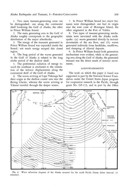
<strong>Alaska</strong> <strong>Earthquake</strong> <strong>and</strong> Tsunami, I-PARARAS-CARAYANNIS 3091. Two main tsunami-generating areas canbe distinguished: one along <strong>the</strong> continentalshelf bordering <strong>the</strong> Gulf <strong>of</strong> <strong>Alaska</strong>; <strong>the</strong> o<strong>the</strong>rin Prince William Sound .2. The main generating area in <strong>the</strong> Gulf <strong>of</strong><strong>Alaska</strong> roughly corresponds to <strong>the</strong> geographicdistribution <strong>of</strong> <strong>the</strong> major aftershocks.3, The energy <strong>of</strong> <strong>the</strong> tsunamis gener ated inPrince William Sound was expended inside <strong>the</strong>Sound ; not much energy escaped this closedregion.4. The long period <strong>of</strong> <strong>the</strong> waves generatedin <strong>the</strong> Gulf <strong>of</strong> <strong>Alaska</strong> is related to <strong>the</strong> longseiche period <strong>of</strong> <strong>the</strong> shallow shelf.5. The preferential radiation <strong>of</strong> energy toward<strong>the</strong> sou<strong>the</strong>ast is attributed to <strong>the</strong> orientation<strong>of</strong> <strong>the</strong> tectonic displacements along <strong>the</strong>continental shelf <strong>of</strong> <strong>the</strong> Gulf <strong>of</strong> <strong>Alaska</strong>.6. The waves arriving at Cape Yakataga had<strong>the</strong>ir origin in .<strong>the</strong> shallow coastal area near <strong>the</strong>Bering Glacier, whereas <strong>the</strong> waves arriving atYakatat traveled through <strong>the</strong> deeper waters.BERINGAf TU l"..~ 1'~~' Ws ' , « r >AL E U T \ A ~ •• ;10 ~A LAS KA, ..• .~ ..o-... AN DRE AN OF IS .7. In Prince William Sound two major tsunamiswere distinguished: one had its originnear <strong>the</strong> west coast <strong>of</strong> Montague Isl<strong>and</strong>, <strong>the</strong>o<strong>the</strong>r originated in <strong>the</strong> Port <strong>of</strong> Valdez.8. Two types <strong>of</strong> tsunami-generating mechanismswere associated with <strong>the</strong> <strong>Alaska</strong> earthquake: (a) waves generated directly by tectonicmovements <strong>of</strong> <strong>the</strong> sea floor, <strong>and</strong> (b) wavesgenerated indirectly from l<strong>and</strong>slides, mudflows,<strong>and</strong> slumping <strong>of</strong> alluvial deposits.9. In Prince W illiam Sound both generationmechanisms were evident , while in <strong>the</strong> generatingarea along <strong>the</strong> Gulf <strong>of</strong> <strong>Alaska</strong>, <strong>the</strong> generatedtsunami was <strong>the</strong> direct result <strong>of</strong> tectonic movements.ACKNOWLEDGMENTSThe work on which this paper is based wassupp orted in part by <strong>the</strong> National Science Foundationunder <strong>the</strong> United States-Japan programfor cooperative research in <strong>the</strong> Pacific, throughgrant N o. GF-1 53, <strong>and</strong> in part by <strong>the</strong> Officeo'?~