May2014
May2014
May2014

Create successful ePaper yourself
Turn your PDF publications into a flip-book with our unique Google optimized e-Paper software.
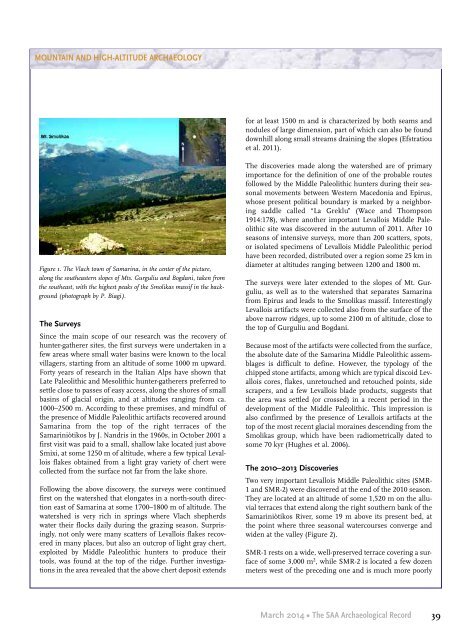
MOUNTAIN AND HIGH-ALTITUDE ARCHAEOLOGYfor at least 1500 m and is characterized by both seams andnodules of large dimension, part of which can also be founddownhill along small streams draining the slopes (Efstratiouet al. 2011).Figure 1. The Vlach town of Samarina, in the center of the picture,along the southeastern slopes of Mts. Gurguliu and Bogdani, taken fromthe southeast, with the highest peaks of the Smolikas massif in the background(photograph by P. Biagi).The SurveysSince the main scope of our research was the recovery ofhunter-gatherer sites, the first surveys were undertaken in afew areas where small water basins were known to the localvillagers, starting from an altitude of some 1000 m upward.Forty years of research in the Italian Alps have shown thatLate Paleolithic and Mesolithic hunter-gatherers preferred tosettle close to passes of easy access, along the shores of smallbasins of glacial origin, and at altitudes ranging from ca.1000–2500 m. According to these premises, and mindful ofthe presence of Middle Paleolithic artifacts recovered aroundSamarina from the top of the right terraces of theSamariniòtikos by J. Nandris in the 1960s, in October 2001 afirst visit was paid to a small, shallow lake located just aboveSmixi, at some 1250 m of altitude, where a few typical Levalloisflakes obtained from a light gray variety of chert werecollected from the surface not far from the lake shore.Following the above discovery, the surveys were continuedfirst on the watershed that elongates in a north-south directioneast of Samarina at some 1700–1800 m of altitude. Thewatershed is very rich in springs where Vlach shepherdswater their flocks daily during the grazing season. Surprisingly,not only were many scatters of Levallois flakes recoveredin many places, but also an outcrop of light gray chert,exploited by Middle Paleolithic hunters to produce theirtools, was found at the top of the ridge. Further investigationsin the area revealed that the above chert deposit extendsThe discoveries made along the watershed are of primaryimportance for the definition of one of the probable routesfollowed by the Middle Paleolithic hunters during their seasonalmovements between Western Macedonia and Epirus,whose present political boundary is marked by a neighboringsaddle called “La Greklu” (Wace and Thompson1914:178), where another important Levallois Middle Paleolithicsite was discovered in the autumn of 2011. After 10seasons of intensive surveys, more than 200 scatters, spots,or isolated specimens of Levallois Middle Paleolithic periodhave been recorded, distributed over a region some 25 km indiameter at altitudes ranging between 1200 and 1800 m.The surveys were later extended to the slopes of Mt. Gurguliu,as well as to the watershed that separates Samarinafrom Epirus and leads to the Smolikas massif. InterestinglyLevallois artifacts were collected also from the surface of theabove narrow ridges, up to some 2100 m of altitude, close tothe top of Gurguliu and Bogdani.Because most of the artifacts were collected from the surface,the absolute date of the Samarina Middle Paleolithic assemblagesis difficult to define. However, the typology of thechipped stone artifacts, among which are typical discoid Levalloiscores, flakes, unretouched and retouched points, sidescrapers, and a few Levallois blade products, suggests thatthe area was settled (or crossed) in a recent period in thedevelopment of the Middle Paleolithic. This impression isalso confirmed by the presence of Levallois artifacts at thetop of the most recent glacial moraines descending from theSmolikas group, which have been radiometrically dated tosome 70 kyr (Hughes et al. 2006).The 2010–2013 DiscoveriesTwo very important Levallois Middle Paleolithic sites (SMR-1 and SMR-2) were discovered at the end of the 2010 season.They are located at an altitude of some 1,520 m on the alluvialterraces that extend along the right southern bank of theSamariniòtikos River, some 19 m above its present bed, atthe point where three seasonal watercourses converge andwiden at the valley (Figure 2).SMR-1 rests on a wide, well-preserved terrace covering a surfaceof some 3,000 m 2 , while SMR-2 is located a few dozenmeters west of the preceding one and is much more poorlyMarch 2014 • The SAA Archaeological Record39