OutdoorIllinois September 2007 Big River State Forest - Illinois DNR ...
OutdoorIllinois September 2007 Big River State Forest - Illinois DNR ...
OutdoorIllinois September 2007 Big River State Forest - Illinois DNR ...

You also want an ePaper? Increase the reach of your titles
YUMPU automatically turns print PDFs into web optimized ePapers that Google loves.
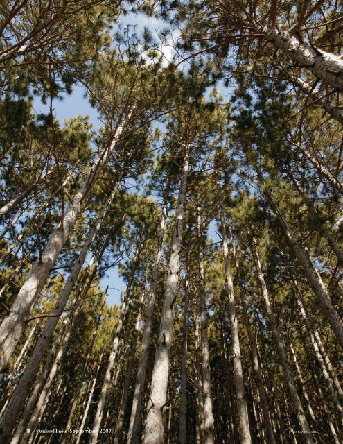
8 / <strong>Outdoor<strong>Illinois</strong></strong> <strong>September</strong> <strong>2007</strong> (Photo by Adele Hodde.)
As one of only four designated <strong>Illinois</strong> forests,not only does <strong>Big</strong> <strong>River</strong> <strong>State</strong> <strong>Forest</strong> offer visitors plenty ofpark activities, but also a rich history lesson.Towering PinesStory and PhotosBy Kathy Andrews<strong>Big</strong> <strong>River</strong> <strong>State</strong> <strong>Forest</strong> lives up toits name.Located on the banks of themighty Mississippi, the HendersonCounty facility provides visitorswith miles of river-front forfishing, birding, boating andwatching barges. And turningaway from the river, stands oftowering pines mark one of four propertiesowned by the state with the designationof state forest.But beyond the obvious, <strong>Big</strong> <strong>River</strong>holds an interesting history.Sac and Fox Indians frequented thearea known as Oquawkiek, or YellowBanks, a term memorialized today in thename of Oquawka, the community 9miles south of the forest. Ma-ka-tai-meshe-kia-kiak,or Chief Black Hawk, alsoclaimed the land as his home ground.Local tradition holds that in May1832, Captain Abraham Lincoln lednearly 2,000 mounted men through thearea on their march to the Black HawkWar. Lincoln’s connection to the areacontinued in October 1858 when he andStephan A. Douglass visited Oquawka,four days apart, during their now-famousLincoln-Douglass Debates.Despite determined attempts, earlypioneers found the shifting, sandy soilsheld little promise for making a living. Sopoor were the soils that by the GreatDepression young men hired throughthe Civilian Conservation Corps werebrought to the area to plant pine trees tostabilize the soils. In 1928, the state of<strong>Illinois</strong> purchased land to establish <strong>Big</strong><strong>River</strong> <strong>State</strong> <strong>Forest</strong> as one of the firststate forests. Subsequent land purchasesin the 1940s and in 1969, plus leaseson U.S. Army Corps of Engineers land,bring the total acreage managed by theDepartment of Natural Resources toapproximately 3,100 acres.Today, historical remnants awaitpark visitors.At the park headquarters, one of twofire towers remaining in <strong>Illinois</strong> remindsus of a day when communication of eminentfire hazards required dedicatedstaff perched high above the forestcanopy. Constructed in 1941, the 60-foot steel tower is listed on the NationalHistoric Lookout Register. An adjacentwindmill, and four additional windmillsalong Windmill Road Scenic Auto Trail(a 15-mile gravel drive providing great<strong>Big</strong> <strong>River</strong> <strong>State</strong> <strong>Forest</strong> boasts milesof river front for fishing, birding,boating and barge-watching.Pines, now towering 30 to 50 feetover <strong>Big</strong> <strong>River</strong> <strong>State</strong> <strong>Forest</strong>, wereplanted during the Depression tostabilize the sandy soils.<strong>September</strong> <strong>2007</strong> <strong>Outdoor<strong>Illinois</strong></strong> / 9
viewing of white-tailed deer, wild turkeysand fall colors), were constructed by theCCC to provide water for youngseedlings, and now provide water for fireprotection purposes and watering holesfor wildlife.<strong>Big</strong> Pines Hiking Trail, a 1.4-milemoderate to easy hike, traversesthrough the oldest pines in the forest. At1.6 miles, Lincoln Hiking Trail also israted a moderate to easy trail and followsthe route Lincoln’s militia menreportedly traveled. This trail passes apioneer cemetery with sandstone markersdating to the 1700s.As rich as the forest is in history, <strong>Big</strong><strong>River</strong> visitors will not be disappointed bythe site’s natural history.At the forefront of the sand communityis the <strong>Big</strong> <strong>River</strong> Natural Area, a 535acre tract identified by the <strong>Illinois</strong> NaturalAreas Inventory in 1976. Composedof dry sand savanna, dry-mesic sandprairie and dry sand habitats, the area issignificant because of the natural qualityConstructed in 1941 and standing at aheight of 60 feet, the fire tower overlooksthe forest canopy. At the time,four windmills also provided water forprotection against forest fires.and size of these communities, andbecause it is contiguous with other similarhabitat in the state forest.Michelle Simone, district heritage biologist,explained how management of thearea emphasizes the need to providehabitat for two state-endangered plants,the large-flowered beard tongue (Penstemongrandiflorus) and Patterson’sbindweed (Stylisma pickeringii), and astate-threatened snake, the westernhognose snake (Heterodon nasicus).“Management of this natural areaincludes prescribed burning, removal ofwoody plants from the prairie and exoticspecies control,” Simone said. “TheseAt a glanceAddress: <strong>Big</strong> <strong>River</strong> <strong>State</strong> <strong>Forest</strong>,R.R. 1, Box 118, Keithsburg, IL 61442.Telephone: (309) 374-2496.Website: www.dnr.state.il.us/lands/landmgt/PARKS/R1/BIGRIVER.HTM.Directions: From the south, east orwest, <strong>Big</strong> <strong>River</strong> <strong>State</strong> <strong>Forest</strong> can bereached from Highway 164, taking theOquawka-Keithsburg blacktop road for 9miles north of Oquawka.Satellite Facilities: The 89-acreDelebar <strong>State</strong> Park is 1.5 miles north ofOquawka near <strong>Illinois</strong> Route 164 andhas a boat launch, fishing docks, campingarea (75 total sites), picnic shelters,playground and trails. The 28-acre GladstoneLake is the hub of the 85-acreHenderson County ConservationArea, offering bank anglers and boaterswith electric trolling motors the chanceto haul in a stringer of bluegill, redearsunfish, largemouth bass, crappie orchannel catfish. Camping (35 Class Csites), picnicking, hiking, ice fishing andice skating are among the other activitiesavailable at Henderson County.Both sites are managed through <strong>Big</strong><strong>River</strong> <strong>State</strong> <strong>Forest</strong>. Near Lock and Dam18, the Henderson Creek Access Areais a 500-acre waterfowl refuge with aboat launch and picnic area. Twenty-fivemiles north of the park office, CrossesCorner provides additional boat accessabove Lock and Dam 17.practices are critical for maintaining thehigh-quality habitat that these uniquespecies require to survive.”Prior to the CCC tree planting program,a mix of prairie and blackjack oakscrub forest once covered a considerableportion of the area. Natural fires,and those ignited by the railroad linesrunning through the area, helped maintainthe communities.(Photo by Barrie McVey/<strong>DNR</strong>.)Built using the tools and techniquesof the late 1800s, replica cabinswere from pine trees harvestedfrom the forest.10 / <strong>Outdoor<strong>Illinois</strong></strong> <strong>September</strong> <strong>2007</strong>
(Photo by Adele Hodde.)Today, much of the forest managementplan focuses on a slow reversionback to original habitats.“Our focus has shifted from annualreplanting of large numbers of pineseedlings to thinning out 5- to 20-acrestands each year,” said district foresterSpanning approximately 3,100 acres,<strong>Big</strong> <strong>River</strong> <strong>State</strong> <strong>Forest</strong> is known forits nature preserve and diversity ofsand-community plants, includingseveral rare species.Barrie McVey. “It is amazing to watchprairie plant seeds, dormant in the soilunder the shade of pine trees for morethan 70 years, germinate and begin theprocess of restoring these native communities.”Additionally, firewood cutters areallowed to obtain a permit from the parkoffice to harvest wood in designatedareas in the forest for $10 a pickup loadand approximately 200-300 logs areharvested each year for constructionpurposes. In 1999, volunteers with theNauvoo Restoration project cut pinelogs, hauling them from the forest usinghorses and chains, for the constructionof replica cabins within the nearby Mormonsettlement.Even with annual timber standimprovement projects, large expansesof pines remain, providing scenic backdropsfor overnight and day-use visitors.<strong>Big</strong> <strong>River</strong> provides diverse, yearroundcamping opportunities. Near thenorth boundary of the facility, 20 equestriancamp sites provide easy access to28 miles of designated horse trails, andan additional 40 miles of fire lanes areopen for trail riders. At <strong>River</strong>view Campground,visitors may opt for one of the 15tent (Class D) sites situated on a sandybeach of the Mississippi, or one of 32Class C sites. Adjacent to that campgroundand situated under the pines, theShady Pines Campground contains 21Class C sites, two picnic shelters (maybe reserved by calling the park officeafter January 1 each year), a horseshoepit and a playground. Additional ClassB/E, D and tent camp sites are availableat Delabar <strong>State</strong> Park, 7.5 miles south of<strong>Big</strong> <strong>River</strong>. Some sites at each park maybe reserved by contacting the <strong>Big</strong> <strong>River</strong>office. Water is shut off at the campgroundsin winter months, and hardy visitorsare advised to call to the park officeto ensure weather conditions have notclosed campground roads.Five picnic areas, including one eachat Campbell Slough and Putney’s Landing,provide tables, camp stoves, drinkingwater, scenic forest or river vistasand easy trail access for the day visitor.A second playground is available at <strong>Big</strong><strong>River</strong> Shady Pines Campgrounds.Boating, fishing and hunting also arepopular with park visitors. Whether toenjoy the sights along the river, water<strong>September</strong> <strong>2007</strong> <strong>Outdoor<strong>Illinois</strong></strong> / 11
ski or to spend a day angling for sunfish,bass or catfish, boaters will find boataccess areas at <strong>River</strong>view Campground(low water can make access difficult partof the year) or a mile south of the campgroundat Putney’s Landing.According to Tony Newton, <strong>Big</strong> <strong>River</strong>site superintendent, sportsmen haveample opportunity to visit the forestthroughout the year.“During the winter months, uplandgame and raccoon hunters sign in at thepark headquarters before venturingafield, and return to report their harvestat the end of their hunts,” Newtonexplained. “In the spring, the forest isdivided into six sections, with turkeyhunters who have received a site-specificpermit trying their luck at calling agobbler into range.”Early fall has 100 dove hunters drawingfor a numbered post on opening day,after which they need only stop by theoffice daily to sign in and out. Fall turkeyand archery and shotgun deer huntinground out the offerings.<strong>Big</strong> <strong>River</strong> <strong>State</strong> <strong>Forest</strong> holds seasonalvariety for visitors. In the fall, scrub oaksset the prairie ablaze with color. Wintervisitors find quiet trails for cross-countryskiing through snow-draped pineboughs, bald eagles perched in a riversidetree, or, if snow levels permit, a sitefor an exhilarating snowmobile ride.Spring wildflowers bring color to theprairie, and the heat of summer finds visitorsenjoying cooling breezes from thedeck of a boat or under fragrant pines.Whether exploring the region for itshistory or natural resources, a stop at<strong>Big</strong> <strong>River</strong> <strong>State</strong> <strong>Forest</strong> will be a highlightof your next trip.A Brief GeologicHistory of theArea of <strong>Big</strong> <strong>River</strong><strong>State</strong> <strong>Forest</strong>riving along or floating down theDMississippi <strong>River</strong>, you may think ofpast cultures that relied on the river forfood, shelter and transportation. Thisrich cultural history of the Mississippi<strong>River</strong> Valley is the most recent reflectionof the complex and intriguing geologichistory of the river and the area.The area of <strong>Big</strong> <strong>River</strong> <strong>State</strong> <strong>Forest</strong>,with its peaceful pine forests and riversidecampgrounds, provides andexcellent opportunity to see the varietyof geologic materials and landformsthat have developed from the forces ofthe mighty Mississippi. Engineeredlevees, locks, and dams contain theriver in many places, but they are ultimatelyno match for the relentlessearth-moving power of the Mississippi<strong>River</strong> through geologic time.Almost all of what we see on theland surface near <strong>Big</strong> <strong>River</strong> <strong>State</strong> <strong>Forest</strong>today is a result of geologicprocesses that occurred during theQuaternary Period. During this time,continental-scale glaciers repeatedlycovered the area of <strong>Big</strong> <strong>River</strong> <strong>State</strong><strong>Forest</strong> and altered the course of theMississippi <strong>River</strong> several times. Theriver was one of the major outlets forglacial meltwater, and the river’scourse today is very different fromwhat it has been in the past. Prior tothe most recent glaciation (about21,000 years ago) and during thetimes between older glaciations (120-150,000 years ago and >500,000years ago), the ancient Mississippi<strong>River</strong> flowed southward toward thearea of the Quad Cities but turnedsoutheastward near Clinton, Iowa andflowed across the Green <strong>River</strong> lowlandsto join what is now the <strong>Illinois</strong><strong>River</strong> near the great bend of the <strong>Illinois</strong>above Peoria. So, the valley ofthe lower part of the modern <strong>Illinois</strong><strong>River</strong> through central <strong>Illinois</strong> was originallycovered by the ancient Mississippi<strong>River</strong>. During these times, theancient Iowa/Cedar river flowed southeastwardthrough Iowa and enteredwhat is now the modern Mississippi<strong>River</strong> valley just south of Muscatine,Iowa. This river flowed through what isnow the area of <strong>Big</strong> <strong>River</strong> <strong>State</strong> <strong>Forest</strong>and joined the ancient Mississippi<strong>River</strong> near St. Louis. During the mostrecent glaciation (about 21,000 yearsago), glaciers moved across <strong>Illinois</strong>from the Lake Michigan basin anddammed the Ancient Mississippi <strong>River</strong>near Hennepin in Marshall County.When this happened, a large lakeformed in the Green <strong>River</strong> lowlandsbetween the Quad Cities and Hennepin.This lake ultimately spilled overinto the ancient Iowa/Cedar river valleyand re-routed the Mississippi <strong>River</strong>into its current path and through thearea of <strong>Big</strong> <strong>River</strong> <strong>State</strong> <strong>Forest</strong>.Today in the Mississippi <strong>River</strong>Valley, most of the landforms areassociated with events during andafter the most recent glaciation andstudying these landforms can helpunravel the geologic history. Forexample, terraces are the remains ofancient floodplains formed at higherelevations when the river was chokedwith the sediment and water gushingfrom the melting glaciers. When theriver lost its abundant sediment supply,due to glacier retreating, the riverdowncut and left behind terraces thatreveal the former river level. Theseflat, continuous surfaces are easy tosee near and in the forest. Parts of anold terrace are located high in theriver valley along the eastern bluff,particularly just north of Bald Bluff.This terrace is thought to be associatedwith the re-routing of the AncientMississippi <strong>River</strong> about 21,000 to18,000 years ago. <strong>Big</strong> <strong>River</strong> <strong>State</strong><strong>Forest</strong> is situated on a large, youngerSand dunes created by glacial deposits from the ancientMississippi <strong>River</strong> are readily evident throughout the area.terrace of the Mississippi <strong>River</strong>, whichformed between 18,000 to 12,000years ago. This terrace likely formedas the continental glaciers meltedback from <strong>Illinois</strong>, Wisconsin and Minnesotafor the last time, and the sedimentsupply to the Mississippi <strong>River</strong>decreased. The terrace is about 30feet above the current river level andis composed of thick, sandy, riverdeposits that are capped by large,wind-blown dunes that trend northwest-southeast.These dunes likelyformed when large quantities of siltand sand were transported within theriver valley during the waning stagesof glaciation. Look for these dunes onthe east side of the Oquawka-Keithsburgblacktop just south of the rangerstation and you will see an undulating,sandy surface overlain by thepine forest. Approximately 20 feet ofthe same wind-blown silt and sanddeposits also lie atop Bald Bluff to theeast of the forest, and wood and otherorganic materials in these depositshave been radiocarbon dated to beabout 13,700 years old.Another geologic feature, preservedas a broad, low-lying valleylocated between the dune-coveredterrace and the eastern valley wall, isvisible when traveling from the stateforest toward Bald Bluff. This valley,called the Edwards <strong>River</strong> paleochannel,is an abandoned stream channelthat was active between 12,000 and10,000 years ago. It is filled withsandy stream deposits that includelayers of reddish-brown clay. Remarkably,these clay beds reflect floodingevents that originated from the LakeSuperior region during the last glacierretreat. Ultimately, as glaciers retreatedfurther north out of <strong>Illinois</strong> andbeyond the Great Lakes Region about12,000 to 10,000 years ago, the Mississippi<strong>River</strong> likely began its transitionfrom a glacial meltwater braided-riversystem to an island braided system,and by about 7,000 years ago, theriver had likely attained a channel patternsimilar to the modern river.The complex history of the Mississippi<strong>River</strong> and its valley is difficult tounravel, but it helps us understand theorigins of the beauty that we see in <strong>Big</strong><strong>River</strong> <strong>State</strong> <strong>Forest</strong> and the surroundingarea. So, while hunting, camping, boatingor hiking in <strong>Big</strong> <strong>River</strong> <strong>State</strong> <strong>Forest</strong>look for the evidence of an excitinggeologic history that made the parkwhat it is today.— Compiled by Jason Thomasonand Joan Jach of the <strong>Illinois</strong> <strong>State</strong>Geological Survey12 / <strong>Outdoor<strong>Illinois</strong></strong> <strong>September</strong> <strong>2007</strong>