ag-2013-14-w-eng
ag-2013-14-w-eng
ag-2013-14-w-eng
- No tags were found...
You also want an ePaper? Increase the reach of your titles
YUMPU automatically turns print PDFs into web optimized ePapers that Google loves.
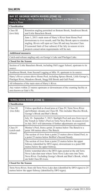
SalmonBAY ST. GEORGE NORTH RIVERS (ZONE 13)Flat Bay Brook, Little Barachois Brook, Southwest and Bottom Brooks,Harry’s RiverClassificationClass III(two fish)Retention angling permitted on Bottom Brook, Southwest Brookand Little Barachois Brook.June 1, <strong>2013</strong>: main stem of Harry’s River from Home Pooldownstream to river mouth, and Flat Bay Brook open to retentionangling. Rivers will open as Class III and may become ClassII (seasonal limit of four salmon) if the July in-season reviewprojects conservation requirements will be met.Additional measuresCatch-and-release angling only on George’s Lake and Pinchgut Lake.Closed for the SeasonSection of Little Barachois Brook, including Old Logger School, upstream to itssource.Southwest Brook, from Second Logging at Mile 19, upstream to its source.Harry’s River system above Home Pool, including Spruce Brook, Little George’s,Pinchgut River, Meadows Brook, St<strong>ag</strong>g Hill Brook and Gull Pond.All tributaries of the main stem of Harry’s River.Any waters within 23 metres upstream or downstream of the counting facility atarea known as Gale’s Pit.TERRA NOVA RIVER (ZONE 5)ClassificationClass III(two fish)Class IV(catch-andrelease)Unless specified as closed area or Class IV, Terra Nova Riverand tributary streams are Class III. This includes Maccles Brook,George’s Brook and Butt’s Brook.July 10– September 7, <strong>2013</strong>: Starlight Pool and area from top ofthe Trench to Tobin’s Pool on Terra Nova River. In-season reviewin July <strong>2013</strong> will determine if further adjustments are required.Morine’s Pool, from a point 25 metres below The Bench to apoint 100 metres above The Bench.The section of river from a point 25 metres above Island Pool, toa point 25 metres below Briffett’s/Second Steady.The section of river from a point 25 metres below the upperfishway (identified by DFO signs), downstream to a point 800metres below the upper fishway.Entire watershed above the DFO signs posted at the old TerraNova Lake dam near where Terra Nova Lake runs into TerraNova River. Excluding George’s Brook and Butt’s Brook, whichare both Class III rivers.Closed for the SeasonTerra Nova River, from old Terra Nova Lake dam (identified by DFO signs) to 25metres below the upper fishway (identified by DFO signs).12 Angler’s Guide <strong>2013</strong>-20<strong>14</strong>


