

ag-2013-14-w-eng
ag-2013-14-w-eng
ag-2013-14-w-eng
- No tags were found...

You also want an ePaper? Increase the reach of your titles
YUMPU automatically turns print PDFs into web optimized ePapers that Google loves.
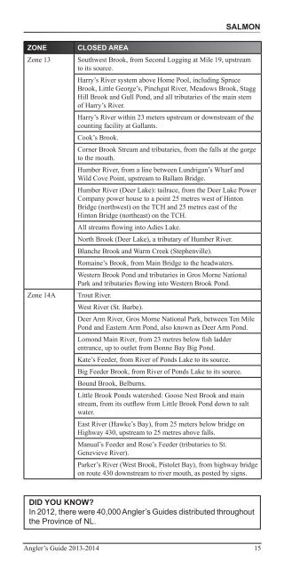
SalmonZONEZone 13Zone <strong>14</strong>ACLOSED AREASouthwest Brook, from Second Logging at Mile 19, upstreamto its source.Harry’s River system above Home Pool, including SpruceBrook, Little George’s, Pinchgut River, Meadows Brook, St<strong>ag</strong>gHill Brook and Gull Pond, and all tributaries of the main stemof Harry’s River.Harry’s River within 23 meters upstream or downstream of thecounting facility at Gallants.Cook’s Brook.Corner Brook Stream and tributaries, from the falls at the gorgeto the mouth.Humber River, from a line between Lundrigan’s Wharf andWild Cove Point, upstream to Ballam Bridge.Humber River (Deer Lake): tailrace, from the Deer Lake PowerCompany power house to a point 25 metres west of HintonBridge (northwest) on the TCH and 25 metres east of theHinton Bridge (northeast) on the TCH.All streams flowing into Adies Lake.North Brook (Deer Lake), a tributary of Humber River.Blanche Brook and Warm Creek (Stephenville).Romaine’s Brook, from Main Bridge to the headwaters.Western Brook Pond and tributaries in Gros Morne NationalPark and tributaries flowing into Western Brook Pond.Trout River.West River (St. Barbe).Deer Arm River, Gros Morne National Park, between Ten MilePond and Eastern Arm Pond, also known as Deer Arm Pond.Lomond Main River, from 23 metres below fish ladderentrance, up to outlet from Bonne Bay Big Pond.Kate’s Feeder, from River of Ponds Lake to its source.Big Feeder Brook, from River of Ponds Lake to its source.Bound Brook, Belburns.Little Brook Ponds watershed: Goose Nest Brook and mainstream, from its outflow from Little Brook Pond down to saltwater.East River (Hawke’s Bay), from 25 meters below bridge onHighway 430, upstream to 25 metres above falls.Manual’s Feeder and Rose’s Feeder (tributaries to St.Genevieve River).Parker’s River (West Brook, Pistolet Bay), from highway bridgeon route 430 downstream to river mouth, as posted by signs.DID YOU KNOW?In 2012, there were 40,000 Angler’s Guides distributed throughoutthe Province of NL.Angler’s Guide <strong>2013</strong>-20<strong>14</strong> 15