HOLLAND FARM OVERALL LAYOUT PLAN 3.0 - Town of Apex
HOLLAND FARM OVERALL LAYOUT PLAN 3.0 - Town of Apex
HOLLAND FARM OVERALL LAYOUT PLAN 3.0 - Town of Apex

Create successful ePaper yourself
Turn your PDF publications into a flip-book with our unique Google optimized e-Paper software.
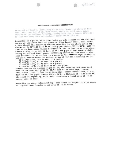
ANNEXATION/REZONINGDESCRIPTIONBeginning at a point, said point being an axle located at the northeastcorner <strong>of</strong> the James Morrison property (Wake County Parcel 0721.04-83-6180) ; thence the following courses according to the above noted map;NOO°41'24"E, 1272.20 feet to an iron pipe; thence S77°11'14"E, 1516.86feet to an iron pipe; thence SOO°44'28"W, 588.90 feet to an iron pipe;thence S78°31'12"E, 105.34 feet to an iron pipe on the western right<strong>of</strong>-way<strong>of</strong> Holland Road; thence continuing across Holland Road to theeast S78°31'12"E, 60.00 feet to a point on the eastern right-<strong>of</strong>-way <strong>of</strong>the road; thence along the eastern right-<strong>of</strong>-way the following calls;1) S11°07'10"W, 159.01 feet to a point;2) S08°44'04"W, 94.02 feet to a point;3) SOO°38'29"W, 61.76 feet to a point;4)thenceS12°06'04"E,leaving the61.36 feet to an ironeastern right-<strong>of</strong>-waypipe;and crossing back over saidroad to the west N89°37'22"W, 69.76 feet to an iron pipe; thenceN89°37'22"W, 1130.17 feet to an iron pipe; thence N89°37'22"W, 416.71feet to an iron pipe; thence NOO°41'24"E, a distance <strong>of</strong> 46.11 feet tothe point <strong>of</strong> beginning, said tract containing a total area <strong>of</strong> 40.53acres, more or less.According to above referenced map, this tract is subject to 0.53 acres<strong>of</strong> right-<strong>of</strong>-way, leaving a net area <strong>of</strong> 40.00 acres.