Cycleways Cycleways - The City of Unley - sa.gov.au
Cycleways Cycleways - The City of Unley - sa.gov.au
Cycleways Cycleways - The City of Unley - sa.gov.au

Create successful ePaper yourself
Turn your PDF publications into a flip-book with our unique Google optimized e-Paper software.
Main South Road<br />
Anzac Highway<br />
Forest Ave<br />
Reserve<br />
Norman Tce<br />
Princess<br />
Margaret<br />
Playground<br />
East Ave<br />
Leah St<br />
Bike lane on collector road (50kmh)<br />
Bike boulevard (40kmh)<br />
Shared-use path<br />
Bike route - no treatment<br />
Local street bike route (40kmh)<br />
Off-road bike route<br />
Collector road without bike lane (50kmh)<br />
DPTI road without bike lane (60kmh)<br />
Traffic signals<br />
Pedestrian Refuge<br />
Pedestrian actuated crossing<br />
Retail and commercial<br />
Education/childcare<br />
Parks and Reserves<br />
Page Park<br />
Everard Park<br />
Reserve<br />
Anzac Highway<br />
Keswick<br />
Military<br />
Barracks<br />
Goodwood<br />
Oval<br />
Dora Gild<br />
Playground<br />
Forestville<br />
Reserve<br />
Lyons St<br />
Keswick Shared Path<br />
Leader St<br />
Devon St Sth<br />
Goodwood Rd<br />
Pascoe St<br />
Rose Tce<br />
Showgrounds<br />
Orphanage Park<br />
Vardon Tce<br />
Valmal Av<br />
Hamilton Boulevard<br />
Mitchell St<br />
Avenue St<br />
Jellicoe Av<br />
Victoria Av<br />
Wayville<br />
Reserve<br />
Parsons St<br />
Hardy St<br />
Joslin St<br />
Railway Sth Tce<br />
Souter Park<br />
Whistler Av<br />
Le Hunte St<br />
Weller St<br />
Northgate St<br />
Heywood<br />
Park<br />
Westall St<br />
Clarke St<br />
King William Rd<br />
Cross Road<br />
Greenhill Rd<br />
Young St<br />
Simpson Pde<br />
Russell St<br />
Annesley<br />
College<br />
Commercial Rd<br />
Bartley Cres<br />
Park St<br />
N<br />
ADELAIDE CBD<br />
Walford Anglican<br />
School for Girls<br />
North <strong>Unley</strong><br />
Play Park<br />
Shared Use Path<br />
Morrie Harrell<br />
Playground<br />
<strong>Unley</strong> Rd - Part time bike lane<br />
Soldiers<br />
Memorial<br />
Gardens<br />
Rugby St<br />
<strong>Unley</strong> Rd<br />
M<strong>au</strong>d St<br />
Frederick St<br />
<strong>Unley</strong> Oval<br />
UNLEY<strong>Cycleways</strong> <strong>Cycleways</strong><br />
UNLEY<br />
Peacock Road<br />
Village<br />
Green<br />
Porter St<br />
Duthy St<br />
Cambridge Tce<br />
Winchester St<br />
George St<br />
Windsor St Linear Reserve<br />
Wattle St<br />
Fern Avenue<br />
Reserve<br />
Highgate St<br />
McLeay Park<br />
Young St<br />
Fuller St<br />
Castle St<br />
Carlton St<br />
Blyth St<br />
Fullarton<br />
Park<br />
Highgate Primary<br />
School<br />
Fisher St<br />
Parkside<br />
Primary<br />
School<br />
Hackett<br />
Reserve<br />
Howard Florey<br />
Reserve<br />
Fullarton Road<br />
Scammell Reserve<br />
Ferguson Ave<br />
UNLEY<br />
CYCLEWAYS<br />
Ferguson Ave<br />
Reserve<br />
Fraser<br />
Reserve<br />
Glen Osmond Road<br />
Moore St<br />
Milton Ave<br />
Riverdale Rd<br />
Bevington Rd<br />
Riverdale Rd<br />
Ridge Park<br />
E85490 FEB 2012
PLAY IT SAFE<br />
Rose Tce<br />
Greenhill Rd<br />
Johnstone Tce<br />
Anzac Highway<br />
Cooke Tce<br />
Young St<br />
Bartley Cres<br />
Leader St<br />
Anzac Highway<br />
Le Hunte St<br />
Parsons St Joslin St<br />
Clarke St<br />
Simpson Pde<br />
Railway Sth Tce<br />
Leah St<br />
<strong>Unley</strong> Rd<br />
Porter St<br />
Hutt Rd<br />
Norman Tce<br />
Young St<br />
Main South Road<br />
M<strong>au</strong>d St<br />
Cambridge Tce<br />
Fuller St<br />
Frederick St<br />
Vardon Tce<br />
Avenue St<br />
Park St<br />
Castle St<br />
Blyth St<br />
East Ave<br />
Glen Osmond Road<br />
Cyclists must obey all the road rules, just like<br />
motorists. This means obeying stop signs and traffic<br />
signals, riding on the left side <strong>of</strong> the road and giving<br />
way to pedestrians on crossings.<br />
Commercial Rd<br />
Duthy St<br />
Wattle St<br />
Northgate St<br />
Rugby St<br />
Valmal Av<br />
Pascoe St<br />
Bevington Rd<br />
Cyclists have the <strong>sa</strong>me rights and responsibilities as<br />
any other road user.<br />
Jelicoe Av<br />
Moore St<br />
Victoria Av<br />
Fisher St<br />
Whistler Av<br />
Highgate St<br />
Winchester St<br />
Cross Road<br />
Milton Ave<br />
Carlton St<br />
Furguson Ave<br />
Riverdale Rd<br />
Riverdale Rd<br />
UNLEY<strong>Cycleways</strong> <strong>Cycleways</strong><br />
UNLEY<br />
SAFETY TIPS FOR CYCLISTS<br />
! Obey the road rules including stopping at<br />
traffic signals and stop signs and giving way<br />
at intersections.<br />
! Keep to the left and ride at least one metre clear<br />
<strong>of</strong> the kerb and parked cars where practicable.<br />
! Look for people opening car doors in front <strong>of</strong> you.<br />
! Be seen. Wear bright coloured clothing during the<br />
day. At night wear light coloured clothing and use<br />
a white front light and red rear light.<br />
! Wear a reflective vest at all times.<br />
! Look for other vehicles at intersections. Never<br />
assume a driver has seen you.<br />
! Ride predictably in a straight line, signal your<br />
intention to turn or change lanes, in advance.<br />
TOO FAR?<br />
Walking or cycling? Why not link up with the public<br />
transport system and go further afield?<br />
Most train stations, tram stops and transport<br />
interchanges have bike lockers available for hire<br />
and you can also take your bike on a local train or<br />
tram for a low cost at peak travel times and for free<br />
in <strong>of</strong>f-peak times.<br />
Visit the Adelaide Metro website at<br />
www.adelaidemetro.com.<strong>au</strong> or call the info line on<br />
8210 1000 for route planning advice and additional<br />
public transport information.<br />
<strong>The</strong> <strong>City</strong> <strong>of</strong> <strong>Unley</strong> <strong>of</strong>fers a community bus to assist<br />
pedestrians getting around the <strong>City</strong>. Visit the<br />
<strong>City</strong> <strong>of</strong> <strong>Unley</strong> website for more information about<br />
routes and timetables.<br />
CYCLEWAYS<br />
CITY OF UNLEY<br />
FRAMEWORK<br />
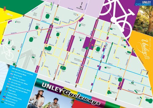
PLAN YOUR ROUTE<br />
This map can be used to identify the best route to<br />
consider when walking or cycling to your destination.<br />
Fortunately most streets in <strong>Unley</strong> have a 40km/h speed<br />
limit, making cycling easier and more enjoyable.<br />
Refer to the map to identify roads with dedicated bike<br />
lanes as they will also create a wider gap between<br />
pedestrians on footpaths and vehicles on the road.<br />
<strong>The</strong> map also shows local streets, shared use paths as<br />
well as traffic signals, pedestrian crossings and other<br />
items <strong>of</strong> interest that will allow you to plan your trip<br />
more effectively.<br />
Always remember that when travelling on shared use<br />
paths that both cyclists and pedestrians use these<br />
paths for transport and recreation.<br />
Although all roads across the <strong>City</strong> are not included on<br />
this map, you may find that they may also be suitable<br />
to use for walking or cycling to your destination.<br />
UNLEY.SA.GOV.AU