Milford-on-Sea Village Design Statement - New Forest District Council
Milford-on-Sea Village Design Statement - New Forest District Council
Milford-on-Sea Village Design Statement - New Forest District Council

Create successful ePaper yourself
Turn your PDF publications into a flip-book with our unique Google optimized e-Paper software.
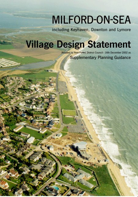
MILFORD-ON-SEAincluding Key h aven, Dow n t<strong>on</strong> and Ly m o reVi l l a ge <strong>Design</strong> Sta tementAdopted by <strong>New</strong> <strong>Forest</strong> <strong>District</strong> <strong>Council</strong> - 16th December 2002 asSupplementary Planning Guidance
M I L F O R D O N S E A V I L L A G E D E S I G N S T A T E M E N TC<strong>on</strong>tentsPage1. Summary of Major Points 12. Introducti<strong>on</strong>: 2The <strong>Village</strong> <strong>Design</strong> <strong>Statement</strong>: what does it aim to do?3. The Character of <str<strong>on</strong>g>Milford</str<strong>on</strong>g>-<strong>on</strong>-<strong>Sea</strong> and its Parish 3-44. Residents’ likes and dislikes of the local envir<strong>on</strong>ment 5-65. Policies affecting the Parish 7-86. Current projects to improve the Parish envir<strong>on</strong>ment 9-107. Maps of <str<strong>on</strong>g>Milford</str<strong>on</strong>g>-<strong>on</strong>-<strong>Sea</strong> and Keyhaven 11-128. <strong>Design</strong> Guidance: 13-14General principles and their applicati<strong>on</strong> in areas of the Parish9. Areas within the ParishC<strong>on</strong>servati<strong>on</strong> Areas 15Western Area 15-16South Central Area 17-18North Central Area 18Eastern Area 19Keyhaven & Lymore Area 2010. The implicati<strong>on</strong>s for the local community: 21Partnership in decisi<strong>on</strong> and m<strong>on</strong>itoring11. Appendix 1 - Relevant objectives and policies 22-24from the <strong>New</strong> <strong>Forest</strong> <strong>District</strong> Local Plan12. Appendix 2 - <strong>Village</strong> <strong>Design</strong> <strong>Statement</strong> - C<strong>on</strong>sultati<strong>on</strong> 24Acknowledgments1. Mr V. Payne Jenkins for photograph of the coast <strong>on</strong> page 42. The Ordnance Survey Office for the maps of <str<strong>on</strong>g>Milford</str<strong>on</strong>g>-<strong>on</strong>-<strong>Sea</strong> and Keyhaven3. <str<strong>on</strong>g>Milford</str<strong>on</strong>g> Envir<strong>on</strong>ment Group for aerial fr<strong>on</strong>t & back cover photograph (1999)
M I L F O R D O N S E A V I L L A G E D E S I G N S T A T E M E N TThe Character of <str<strong>on</strong>g>Milford</str<strong>on</strong>g> and itsParish<str<strong>on</strong>g>Milford</str<strong>on</strong>g> itself, originating in Sax<strong>on</strong> times <strong>on</strong> gently sloping land north of the DanesStream, was recorded as an established settlement in the Domesday Book. It is <strong>on</strong>e ofthe few remaining coastal villages <strong>on</strong> the Hampshire Coast and retains its identity duemainly to the very important Green Belts between <str<strong>on</strong>g>Milford</str<strong>on</strong>g> and Bart<strong>on</strong>-<strong>on</strong>-<strong>Sea</strong> to the Westand Evert<strong>on</strong> to the North. The Green Belt between <str<strong>on</strong>g>Milford</str<strong>on</strong>g> and Keyhaven to the Eastsecures the hamlets of Keyhaven and Lymore.Its historic church, dating from the 12th Century, replaced the first church of wood orst<strong>on</strong>e built between 1079 -1086. Its spacious village green was part of a larger area ofancient comm<strong>on</strong> land and as a mediaeval village it had a manor, vicarage and millbuildings, still identifiable today.All Saints Church and LychgateIt remained a small mainly agricultural settlement of some 50 or so people until the lastdecades of the 19th Century, when Col<strong>on</strong>el Cornwallis-West of <strong>New</strong>lands Manor aimedto make <str<strong>on</strong>g>Milford</str<strong>on</strong>g> a fashi<strong>on</strong>able resort (called <str<strong>on</strong>g>Milford</str<strong>on</strong>g>-<strong>on</strong>-<strong>Sea</strong>) complete with pier, railwaystati<strong>on</strong>, public baths, hydropathic establishment and a golf links. The plans failedprimarily due to lack of capital and of market interest.Their legacy, however, includes the very popular Pleasure Grounds, running al<strong>on</strong>g theDanes Stream Valley into the heart of the village, an example of ancient semi-naturalwoodland with a huge variety of trees and rich in wildlife; the present cliff top roadlayout; the generous open space there with dramatic views to the Isle of Wight andmemories of large buildings such as the Rookcliff Hotel, now the site of <strong>on</strong>e of theblocks of flats overlooking the sea. The core of the village, around the Green and theroad juncti<strong>on</strong> leading to Keyhaven, still c<strong>on</strong>tains characteristic small properties datingfrom the 17th and 18th Centuries, interspersed with a few good examples of lateVictorian and early 20th Century development.The Pleasure GroundsWith a Parish populati<strong>on</strong> of about 4600 at present, mostly in <str<strong>on</strong>g>Milford</str<strong>on</strong>g>, a figure that isdoubled in summer by people staying in the peripheral caravan parks and in hotels andlodgings, the village is now a busy local centre and a popular destinati<strong>on</strong> for tourists andday trippers. Development in its western parts al<strong>on</strong>g the high ground <strong>on</strong> each side ofthe Danes Stream Valley c<strong>on</strong>sists of individual houses originally in a spacious, leafysetting. Fr<strong>on</strong>ting the clifftop there are large blocks of flats built in the 1960s, withterraced houses inland of them. Housing estates were built in the 1960s and 70s tothe north of the village centre and earlier, to the east <strong>on</strong> either side of the road toKeyhaven. This road also serves a small industrial area and a holiday caravan park.Cottages in Keyhaven Road3
M I L F O R D O N S E A V I L L A G E D E S I G N S T A T E M E N TThe agricultural envir<strong>on</strong>ment of the Parish c<strong>on</strong>sists of mixed and dairy farming, some ofwhich is <strong>on</strong> top quality land. It tends to have large fields and few hedges but there issome woodland and newly planted shelter-belts and the area is well provided withfootpaths. Farmland surrounds the small linear hamlets of Lymore and Downt<strong>on</strong> andthe early 19th Century Gothic style mansi<strong>on</strong> <strong>New</strong>lands Manor, now c<strong>on</strong>verted into flats.It also surrounds the two large caravan parks to the northwest and <strong>on</strong>e to the southeastof the village and the former Hordle House school, built around a Victorian core.The most attractive features of the Parish’s landscape setting, however, lie <strong>on</strong> thecoastal side. To the south-west of the village the clifftop is a very popular open spacewith natural vegetati<strong>on</strong> and a much used footpath that gives access to the beach andgroups of beach huts, and also leads to Hurst Spit and Keyhaven. The views from thisfootpath over Christchurch Bay and the Needles are dramatic. At the start of theSolent Way, this footpath overlooks Sturt P<strong>on</strong>d at the sea outlet of the Danes Stream.It c<strong>on</strong>tinues eastwards towards Lymingt<strong>on</strong>, past the reedbeds of the small estuary ofAv<strong>on</strong> Water and the wild coastal saltings at Keyhaven, giving w<strong>on</strong>derful views andopportunities for bird watching.<strong>New</strong>lands Manor - Listed BuildingHurst Castle, <strong>on</strong> the southern end of Hurst Spit is <strong>on</strong>e of the chain of coastal castlesbuilt by Henry VIII, now framed by two Victorian defensive wings. It can also bereached by ferry from Keyhaven and has become an important tourist attracti<strong>on</strong>. SturtP<strong>on</strong>d, the Spit, the saltings and reedbeds are of nati<strong>on</strong>al, even internati<strong>on</strong>al, wildlifevalue, as is the Keyhaven River itself, which is a busy yachting centre in summer.The hamlet of Keyhaven, sheltered by Hurst Spit, was a small port by the 13th Century,a centre for making salt, fishing and wildfowling. The salt industry lasted until overtakenby competiti<strong>on</strong> from Cheshire salt mines in the early years of the 19th Century.Keyhaven, c<strong>on</strong>nected by road to <str<strong>on</strong>g>Milford</str<strong>on</strong>g>-<strong>on</strong>-<strong>Sea</strong>, has an open area of importance in itssmall Green and adjoining low lying field known as ‘Baskets’, a number of finevernacular buildings, and some of more recent design that are also of interest facing thewaterside. Despite its growing attracti<strong>on</strong> to yachtsmen, fishermen, tourists, walkersand bird-watchers, Keyhaven is a peaceful place in a beautiful but exposed setting, witha community identity of its own.Coastal View Looking EastKeyhaven Yacht Club4
M I L F O R D O N S E A V I L L A G E D E S I G N S T A T E M E N TResidents’ likes and dislikes of thelocal envir<strong>on</strong>mentWhat do residents like and dislike about the local envir<strong>on</strong>ment, and what improvementswould they like to see?One of the essentials for a <strong>Village</strong> <strong>Design</strong> <strong>Statement</strong> is to know how people regard theirlocal neighbourhood, its strengths and weaknesses. As a starting point, therefore, aquesti<strong>on</strong>naire was included in the Parish <strong>New</strong>sletter for Spring 1999, sent to everyhousehold. This sought informati<strong>on</strong> <strong>on</strong> what is liked best and least about the villageenvir<strong>on</strong>ment, the scale and appearance of its buildings (including recent developments),<strong>on</strong> new features that might be welcome, and <strong>on</strong> preferences e.g. whether new buildingshould be in keeping with the character of the village, or more modern. Informati<strong>on</strong>was also sought <strong>on</strong> the number of residents in each household, by age groups, and howl<strong>on</strong>g people had lived in the Parish.<str<strong>on</strong>g>Milford</str<strong>on</strong>g> <strong>Village</strong> GreenFrom the 2500 questi<strong>on</strong>naires sent round with the <strong>New</strong>sletter, replies were receivedrepresenting 112 people. Of these, five were aged under 18, five between 18 and 30,twenty-seven between 31 and 60, and seventy-five were over 60. In additi<strong>on</strong> to thereturn of individual questi<strong>on</strong>naires menti<strong>on</strong>ed above, a meeting of the village groups wasarranged from which 134 questi<strong>on</strong>naires were returned. The resp<strong>on</strong>ses from both ofthese sources gave an interesting snapshot of local opini<strong>on</strong>, the highlights of which are:(Note: Column 1 shows results from individual questi<strong>on</strong>naires and column 2 those from<strong>Village</strong> Group questi<strong>on</strong>naires).Liked best about the village (1) (2)Cliff Top Flats<strong>Village</strong> Green 94% 75%*Shops around the Green 44% -Victorian and Edwardian houses 39% -All Saints’ Church 23% 52%Westover Hall - 28%Myrtle Cottage - 26%<strong>Village</strong> as it is - 22%*includes <strong>Village</strong> Green and shopsRecent DevelopmentsDanestream Court 22% 33%White House c<strong>on</strong>versi<strong>on</strong> 21% 54%Church Meadows 10.5% -Liked leastDanestream CourtCliff-top flats 44% 60%Flat roofed and modern buildings 28% -Dilapidated shops 21% -Church Meadows 9.5% -Traffic problems - 22%5
M I L F O R D O N S E A V I L L A G E D E S I G N S T A T E M E N TFurther needsBetter traffic management 49% -C<strong>on</strong>versi<strong>on</strong> of the former youthclub to a Community Centre 24% 25%More buses - 23%More policing - 22%Artificial bowling green - 18%Preferences for design of new buildingsKeep the village as it is, with‘older-type’ and ‘village style’properties in keeping with theneighbourhood 40% -Scale and appearance of newbuildings should match theneighbourhood - 100%No more modern style buildings - 93%Keep to ‘older type of style’ - 87%Retain original windows <strong>on</strong> olderhouses - 22%Allow more modern buildings but<strong>on</strong>ly if they are not ‘boxes’,are in scale and of quality, andhave the right ‘feel’ about them 9% -The White House - Listed BuildingIn additi<strong>on</strong> to the earlier questi<strong>on</strong>naires an exhibiti<strong>on</strong> was held in January 2002 at whichthe draft VDS was presented. 850 copies of this draft were purchased by villagers. Afurther questi<strong>on</strong>naire was completed by 119 people out of the 250 attendees, with anadditi<strong>on</strong>al 45 resp<strong>on</strong>ses submitted shortly after the event. The results largely c<strong>on</strong>firmedthe earlier findings, for example:Almost 80% placed high priority <strong>on</strong> reducing traffic c<strong>on</strong>gesti<strong>on</strong>, and 54.9% were infavour of pedestrianising the High Street between the George & Mary lamppost and theRed Li<strong>on</strong>.Westover Hall Hotel - Listed BuildingAlmost 92% wanted no fur ther increase in the density of building within the Parish, 93%wanted to restrict any further large new developments of flats and almost 90% wanted tosee restricti<strong>on</strong>s placed <strong>on</strong> the use of flat roofs being used <strong>on</strong> extensi<strong>on</strong>s. Over 88%preferred to see present restricti<strong>on</strong>s <strong>on</strong> building above two storeys al<strong>on</strong>g the seafr<strong>on</strong>textended to other areas and over 74% preferred to see older properties c<strong>on</strong>verted intoflats/apartments rather than any further new building.Over 76% encouraged the provisi<strong>on</strong> of more lower cost housing in the Parish, 53% theprovisi<strong>on</strong> of more recreati<strong>on</strong>al space and sports facilities, 69.5% the provisi<strong>on</strong> for moreaccess for the disabled and 67% wanted more facilities for young people.On envir<strong>on</strong>mental issues over 75% would like to see rural footpaths improved, 44% moreseating in the Pleasure Grounds, over 80% more native trees and hedges <strong>on</strong> openspaces and almost 69% were in favour of preserving and replanting Scots Pines.Myrtle Cottage - Listed Building6
M I L F O R D O N S E A V I L L A G E D E S I G N S T A T E M E N TPolicies affecting the ParishThe present planning and c<strong>on</strong>servati<strong>on</strong> policies affecting the Pa ri s h[ I l l u st r a ted by Map <strong>on</strong> pages 11 & 12 ]The <strong>New</strong> Fo re st Dist rict Local Plan (Fi rst Alterati<strong>on</strong> Revised Deposit - Fe b ru a ry 2003)c o n tains a number of policies to be applied Dist rict-wide, and for individual built-up are a ss u ch as Milfo rd-<strong>on</strong>-<strong>Sea</strong>. (See Appendix 1)Westover House - Listed BuildingAt Dist rict-wide level these cover general matte rs such as the scale, appearance, sitingand landscape re qu i rements for new deve l o p m e n t; the protecti<strong>on</strong> of listed buildings,C o n s e rvati<strong>on</strong> Areas, Areas of Special Characte r, the coast, landscape fe a t u res, and site sof imp o rtance for wildlife or arch a e o l o g y; the safe g u a rding of ex i sting and pro p o s e dfo ot p a ths, cyc l eways and bri d l eways; the c<strong>on</strong>straints applying in the Green Belt and Are a sof Outstanding Natural Beauty; cri te ria to obtain a balanced dist ributi<strong>on</strong> of re c reati<strong>on</strong> andto u rism; the needs for less ex p e n s i ve housing, for local emp l oyment and for traffi cm a n a gement. Guidance <strong>on</strong> aspects of these policies is developed further in the Dist ri c tC o u n c i l ’s booklet <strong>on</strong> <strong>Design</strong> for Community Safety (1999) and their Residential <strong>Design</strong>Guide for Rural Are a s .M o st imp o rta n t ly the Local Plan st i p u l a tes that “ Mi l f o rd - o n - <strong>Sea</strong> has been ruled out forany significant expansi<strong>on</strong> in view of the high quality agricultural land which surro u n d sit, and its sensitive positi<strong>on</strong> in the landscape and <strong>on</strong> the coast; it is closely surrounded bythe Green Be l t .” The Local Plan Fi rst Alterati<strong>on</strong> Revised Deposit (Feb.2003) proposes toinclude a re fe rence to its poor drainage system as a further reas<strong>on</strong> for re straint. Therea re also increasing traffic and parking problems which need to be addre s s e d .Agricultural land - Vidle Van Farm, Keyhaven<strong>New</strong> flats in Hurst Road showing height re st ri c t i o n sPolicy MS-1 of the adopted <strong>New</strong> Fo re st Dist rict Local Plan re st ricts the height of newbuildings <strong>on</strong>ly <strong>on</strong> the defined seafr<strong>on</strong>t. Whilst this is imp o rtant, it does not go far enoughto protect the ch a r a c ter of other parts of the village which are under pre s s u re for newd evelopment. <strong>New</strong> Fo re st Dist rict <strong>Council</strong> has been re qu e sted in the rev i ew of their LocalPlan to insert new policies limiting residential development to a maximum height of twosto reys th roughout the village. Other types of development should not be allowed toexceed the height of any buildings to be replaced exc e pt where th e re would be noh a rmful impact having re ga rd to the ch a r a c ter established by the heights of oth e rbuildings in the immediate locality.These principles are ve ry imp o rtant in protecting and enhancing the ch a r a c ter of th ev i l l a ge and we re supported by 88% of the people visiting the exhibiti<strong>on</strong> of the draftp roposals. This Vi l l a ge <strong>Design</strong> Sta tement can <strong>on</strong>ly be based <strong>on</strong> policies which arec o n tained in the adopted Local Plan. There is st r<strong>on</strong>g support in the village for th ei n t roducti<strong>on</strong> of st ri c ter policies th rough the Local Plan rev i ew process, and in the inte ri mthe Dist rict <strong>Council</strong> has been urged to use adopted Local Plan Policy DW-E1 (GeneralD evelopment Cri te ria) to re st rict the scale and height of new building th roughout the village .*(See page 8).7
M I L F O R D O N S E A V I L L A G E D E S I G N S T A T E M E N T*At its <strong>Council</strong> meeting of 16 December 2002 <strong>New</strong> Fo re st Dist rict <strong>Council</strong> adopted the Milfo rd - o n -<strong>Sea</strong> Vi l l a ge <strong>Design</strong> Sta tement as Supplementa ry Planning Guidance to the <strong>New</strong> Fo re st Dist rict LocalPlan. The <strong>Council</strong> has also approved an amendment to the <strong>New</strong> Fo re st Dist rict Local Plan delet i n gPolicy MS-1 and replacing it with the fo l l owing new policy:Policy MS-1A Height of new development in Mi l f o rd - o n - Se aa. D evelopment resulting in buildings of more than two sto reys in height where th ey are to be usedfor residential purposes (including flats) will not be perm i t ted; andb. D evelopment for purposes other than residential (which includes flats) shall be no higher than th ebuilding which is to be replaced, exc e pt where th e re would be no harmful impact having re ga rd tothe ch a r a c ter established by the heights of buildings in the immediate locality.Specific policies also apply to Areas of Special Character, of which 13 are south of theDanes Stream valley and 12 are to the north. These include the spacious residentialareas with mature gardens and trees that are characteristic of Victorian and Edwardian<str<strong>on</strong>g>Milford</str<strong>on</strong>g>. Here, new building will <strong>on</strong>ly be permitted if it does not materially change theoverall character and retains space between buildings, trees, woodland and otherimportant features. In the north of the Parish, the grounds of <strong>New</strong>lands Manor areprotected as an Historic Landscape. The Plan also includes the safeguarding of land fora new cycleway from Shorefield Country Park towards the village, proposals for acycleway from Keyhaven towards Lymingt<strong>on</strong> al<strong>on</strong>g the Ancient Highway, and for afootpath running parallel with the road linking <str<strong>on</strong>g>Milford</str<strong>on</strong>g>-<strong>on</strong>-<strong>Sea</strong> and Keyhaven.The adopted C<strong>on</strong>servati<strong>on</strong> Area Appraisal for <str<strong>on</strong>g>Milford</str<strong>on</strong>g>-<strong>on</strong>-<strong>Sea</strong> (2000), and the earlierc<strong>on</strong>servati<strong>on</strong> area leaflet covering Keyhaven, aim to set out more detailed designguidance than is possible in a Local Plan. They list key points for the design of newdevelopment; the need to make a positive c<strong>on</strong>tributi<strong>on</strong> to the general character of theenvir<strong>on</strong>ment, including existing buildings, the spaces between them, and views withinand out of the area. The leaflets also highlight the importance of scale, roof span andpitch, storey heights, building line and orientati<strong>on</strong>, sensitive use of materials; the needfor colour and texture to blend with older buildings; design of doors and windows; thepotential for archaeological discovery; and the need to get expert professi<strong>on</strong>al designadvice. The C<strong>on</strong>servati<strong>on</strong> Area Appraisal sets out the implicati<strong>on</strong>s for the two parts ofthe Area focussed respectively <strong>on</strong> the High Street and the Green; and <strong>on</strong> the Old Mill,Barnes Lane and Church Hill, the Old House, All Saints Church and Hall area.The Old Mill Barn - Listed building in C<strong>on</strong>servati<strong>on</strong> A re aThe Old House - Listed building in C<strong>on</strong>servati<strong>on</strong> Are aMenti<strong>on</strong> should also be made of the Keyhaven River Management Strategy, initiated bythe <strong>District</strong> <strong>Council</strong>’s Keyhaven River C<strong>on</strong>sultative Committee, now the Keyhaven FocusGroup, which sets a limit to the number of moorings <strong>on</strong> the river and the capacity ofdinghy parks, in accordance with coastal c<strong>on</strong>servati<strong>on</strong> policies in the HampshireStructure Plan and the Local Plan.The <strong>New</strong> <strong>Forest</strong> <strong>District</strong> Coastal Management Plan has been instrumental in initiatingwork <strong>on</strong> the envir<strong>on</strong>mental improvements to the clifftop open spaces. Its proposals arereflected in current works (see <strong>Sea</strong>fr<strong>on</strong>t Improvement Scheme <strong>on</strong> page 9).Barnes Lane - SouthImportance of retaining rural quality8
M I L F O R D O N S E A V I L L A G E D E S I G N S T A T E M E N TCurrent projects to improve the Parishenvir<strong>on</strong>mentProjects to help solve various envir<strong>on</strong>mental problems in the Parish stem from theforegoing plans and also from initiatives by the Parish <strong>Council</strong> and the <str<strong>on</strong>g>Milford</str<strong>on</strong>g>Envir<strong>on</strong>ment Group (MEG).Studland Comm<strong>on</strong>To tackle problems of landscape and wildlife c<strong>on</strong>servati<strong>on</strong>, a great deal of work hasbeen d<strong>on</strong>e by the Parish <strong>Council</strong> (with its Woodland Management Company) and MEGworking closely together to improve the appearance and ecological quality of thePleasure Grounds, Studland Comm<strong>on</strong> and Sharvells Copse. This will be <strong>on</strong>goingfor several years under a <strong>Forest</strong>ry Commissi<strong>on</strong> Woodland Grant Scheme, with a view toobtaining ‘Local Nature Reserve’ designati<strong>on</strong>. A Management Plan has been preparedby English Nature in c<strong>on</strong>juncti<strong>on</strong> with the Envir<strong>on</strong>ment Agency, <strong>New</strong> <strong>Forest</strong> <strong>District</strong><strong>Council</strong>, the Hampshire Wildlife Trust, the Parish <strong>Council</strong> and <str<strong>on</strong>g>Milford</str<strong>on</strong>g> Envir<strong>on</strong>mentGroup for Sturt P<strong>on</strong>d and its reedbeds which should secure an island refuge anddevelop the existing wet vegetati<strong>on</strong>al marsh for this internati<strong>on</strong>ally important wildfowlarea, and provide a basis for seeking designati<strong>on</strong> as another ‘Local Nature Reserve’.Al<strong>on</strong>g the coast a <strong>Sea</strong>fr<strong>on</strong>t Improvement Scheme is under way. The whole footwayfrom the White House to the Marine Café will be improved, both from an aesthetic and asafety point of view, bearing in mind wheelchair users. The sea wall will be made moreattractive with low-level c<strong>on</strong>cealed lighting therein. Thought could be given toestablishing a separate cycleway al<strong>on</strong>g the clifftop. The clifftop, whilst retaining itsnatural appearance, will be improved by reducing the amount of street furniture andslightly raising the earth bunds <strong>on</strong> the southern boundaries of the car parks withoutimpairing sea views from parked cars. In Keyhaven harbour various projects areinitiated as necessary in accordance with the Keyhaven River Management Strategy,for example to improve the launching facilities in the river, especially for the disabled.Sturt P<strong>on</strong>dTraffic is becoming a serious problem in <str<strong>on</strong>g>Milford</str<strong>on</strong>g>-<strong>on</strong>-<strong>Sea</strong> and Keyhaven, especially atpeak times in the summer when some roads and car parks are nearing capacity. It isc<strong>on</strong>sidered essential to proceed urgently with a Traffic Management Plan to thebenefit of both pedestrians and motorists, in the interest of safety, ease of access andprotecti<strong>on</strong> of the envir<strong>on</strong>ment. For example, primarily as a result of c<strong>on</strong>cerns raised bythe Parish <strong>Council</strong>, both <strong>New</strong> <strong>Forest</strong> <strong>District</strong> <strong>Council</strong> and the Hampshire Police Authorityhave been active in rati<strong>on</strong>alising parking arrangements in the High Street, andestablishing area-wide parking c<strong>on</strong>trols in Keyhaven. The George & Mary lamppost hasbeen moved marginally northwards embracing a crossing therein for pedestrians fromoutside ‘Muffins’ to a small cut-out <strong>on</strong> the edge of the <strong>Village</strong> Green. At present accessto the High Street is prohibited from the western end and c<strong>on</strong>siderati<strong>on</strong> should be givento introducing a <strong>on</strong>e-way system from the George & Mary lamppost to the Red Li<strong>on</strong>.More provisi<strong>on</strong> for disabled drivers in the <strong>Village</strong> might be made by increasing thenumber of reserved spaces at the foot of the Green, at the same time reducing thenumber in the <strong>Sea</strong> Road car park.Church Hill parking and traf fic problem9
M I L F O R D O N S E A V I L L A G E D E S I G N S T A T E M E N TAdditi<strong>on</strong>al improvements will probably have to be c<strong>on</strong>sidered in the future as trafficc<strong>on</strong>tinues to increase. There is a search for further parking sites near the centre of thevillage.One particular project that is of great importance to community life in the village is theproposed replacement of the former Youth Club with a Community Centre.The Youth Club has now been demolished and planning permissi<strong>on</strong> has been receivedfor its replacement with a larger purpose-built, multi-purpose hall. The new hall will bedependent <strong>on</strong> a Lottery Grant, a loan from the Parish <strong>Council</strong> and public subscripti<strong>on</strong>.Traditi<strong>on</strong>al youth facilities, for example youth clubs, have l<strong>on</strong>g since been replaced insome other towns and villages with ‘mini activity centres’ which often include BMXtracks, skateboard ramps and rollerblading. Whilst recognising the need for local ‘activitycentres’ for our teenagers, making the provisi<strong>on</strong> has not proved easy. It is welldocumented that boredom in a minority of youngsters often leads to vandalism or otherpetty crime. It is, therefore, imperative that we address the need for teenage activityprovisi<strong>on</strong>. Our under-fives and under-twelves are being catered for in two majorprojects, <strong>on</strong>e at Carringt<strong>on</strong> Lane Play Park, the other (for under-fives <strong>on</strong>ly) al<strong>on</strong>g ourseafr<strong>on</strong>t <strong>on</strong> the old Putting Green. The latter will also serve as a facility for our manyfamily holidaymakers. Youngsters are currently being invited to work more closely withindependent youth workers to develop an understanding of their needs and aspirati<strong>on</strong>s.George & Mary LamppostCurrently there are two recreati<strong>on</strong> grounds in <str<strong>on</strong>g>Milford</str<strong>on</strong>g>-<strong>on</strong>-<strong>Sea</strong>. Carringt<strong>on</strong> Lane, asmenti<strong>on</strong>ed above, and Barnes Lane which is currently used for football and cricket.However, the <strong>New</strong> <strong>Forest</strong> <strong>District</strong> <strong>Council</strong> Local Plan allocates an area close to theSchool for further recreati<strong>on</strong>al facilities and there is a possibility of re-allocating thefootball facility to this site.Carringt<strong>on</strong> Lane Play ParkProposed Community Centre10
M I L F O R D O N S E A V I L L A G E D E S I G N S T A T E M E N TDOWNTON19239944Key11Built-up area boundaryRestricti<strong>on</strong> <strong>on</strong> height of new development(Policy MS-1A)Green belt(Policy DW-E26, Secti<strong>on</strong> C3)Site of Special Scientific Interest(Policy DW-E31, Secti<strong>on</strong> C4Site of Special Scientific Interest/SpecialProtecti<strong>on</strong> Area/Ramsar Site/Special Area ofC<strong>on</strong>servati<strong>on</strong> (Policy DW-E31, Secti<strong>on</strong> C4)Site of Importance for Nature C<strong>on</strong>servati<strong>on</strong>(Policy DW-E32, Secti<strong>on</strong> C4)C<strong>on</strong>servati<strong>on</strong> Area(Policies DW-E19 to DW-E22, Secti<strong>on</strong> C2)Area of Special Character(Policy DW-E8, Secti<strong>on</strong> C1)Landscape feature(Policy DW-E9, Secti<strong>on</strong> C1)Envir<strong>on</strong>mental ImprovementsLocal Shopping Fr<strong>on</strong>tageProposed Footpath(Policy DW-T14, Secti<strong>on</strong> C9)Safeguarded Cycleway(Policy DW-T15, Secti<strong>on</strong> C9)Public Open Space (existing)(Policy DW-R1 Secti<strong>on</strong> C10)Public Open Space (proposed)(Policy MS-2 & MS-3)Beach Huts(Policy DW-C9, Secti<strong>on</strong> C13)Indicative areas where Envir<strong>on</strong>ment Agency to bec<strong>on</strong>sulted about risk from flooding (subject torevisi<strong>on</strong> by Envir<strong>on</strong>ment Agency). (Policy DW-E40,Secti<strong>on</strong> C7)8
M I L F O R D O N S E A V I L L A G E D E S I G N S T A T E M E N TLYMORE5MILFORD-ON-SEAKEYHAVEN674Numerical Key10Shorefield Country Park Holiday Centre 1Sharvells (Shorefield) Copse 2Studland Comm<strong>on</strong> 34Car Parks 4Primary School 54410Norman Church 6<strong>Village</strong> Green 7White House 8Pleasure Grounds 9Sturt P<strong>on</strong>d10This map is based up<strong>on</strong> Ordnance Survey material from <strong>New</strong> <strong>Forest</strong> <strong>District</strong> <strong>Council</strong> Local Plan Maps with thepermissi<strong>on</strong> of Ordnance Survey <strong>on</strong> behalf of the C<strong>on</strong>troller of Her Majesty’s Stati<strong>on</strong>ery Office © Crown copyright.Unauthorised reproducti<strong>on</strong> infringes Crown copyright and may lead to prosecuti<strong>on</strong> or civil proceedings.<strong>New</strong> <strong>Forest</strong> <strong>District</strong> <strong>Council</strong>. Licence no. LA078719. Published 2001.12
M I L F O R D O N S E A V I L L A G E D E S I G N S T A T E M E N T<strong>Design</strong> GuidanceGeneral principles and their applicati<strong>on</strong> in areas of the Parish:The foregoing commentary <strong>on</strong> the character of the Parish, the views of residents, thepolicy c<strong>on</strong>text set by planning documents, and the programme of projects, are anessential introducti<strong>on</strong> to the design guidance and ideas <strong>on</strong> new projects in this<strong>Statement</strong>.The guidance takes account of these and is built up from studies of individual parts ofthe Parish by the working group described <strong>on</strong> page 2. Before giving this, however, it isuseful to set out some general principles relating to the scale, form, detailing, materialsand colour which might help new buildings or modernised old <strong>on</strong>es to fit in satisfactorilythroughout the area. Important advice <strong>on</strong> these matters is also given in <strong>New</strong> <strong>Forest</strong><strong>District</strong> <strong>Council</strong>’s Residential <strong>Design</strong> Guide for Rural Areas.<strong>New</strong> house at Lymore which suits its surroundingsScaleThe first is the scale of a building. Scale is not just size. It is rather the relativedimensi<strong>on</strong>s and proporti<strong>on</strong>s of the elements of the building to each other, comparedwith other buildings nearby and with the surrounding envir<strong>on</strong>ment. <str<strong>on</strong>g>Milford</str<strong>on</strong>g> hasbuildings of many sizes but it is important that the scale of any new building suits itssurroundings. For instance, in an area of Edwardian houses new dwellings, whetherhouses or flats, should be of a similar size. Scale relates not <strong>on</strong>ly to a building, but alsoto the space between it and its neighbours, particularly so in this area where the settingin the landscape is so important. <strong>New</strong> buildings should have the same impressi<strong>on</strong> ofspace around them as surrounding <strong>on</strong>es.Old and new Coastguard Cottages at KeyhavenSaltgrass Lane in Keyhaven also has large houses, but there the houses are fromdifferent periods, and although the design of each is very dissimilar, the size and spacearound them enables them to form a homogeneous whole. The same applies in themany parts of <str<strong>on</strong>g>Milford</str<strong>on</strong>g>-<strong>on</strong>-<strong>Sea</strong> where the buildings are smaller; often this is because theyare older, for instance in Keyhaven Road and Lymore Lane. Scale is also particularlyrelevant to extensi<strong>on</strong>s to buildings. If, for instance, a house is extended so that theoriginal building is dwarfed by the new, the result looks inappropriate. All thesec<strong>on</strong>siderati<strong>on</strong>s are reflected in the Local Plan, for example in the Areas of SpecialCharacter and al<strong>on</strong>g the <strong>Sea</strong>fr<strong>on</strong>t.FormSketch showing inappropriate flat roofed extensi<strong>on</strong>The form of new building is essentially to do with its shape and it is closely related to itsmass. Certain areas have buildings of similar form: narrow or wide fr<strong>on</strong>tages, flat fr<strong>on</strong>tsor bay windows, steep pitched or shallow pitched roofs, tall or ornamental chimneys. Ifa new building or extensi<strong>on</strong> echoes these forms, even if the design is modern, thebuilding can be in harm<strong>on</strong>y with its neighbours. This is particularly important wherehouses are close together or terraced; for instance a flat roofed extensi<strong>on</strong> in an area ofpitched roofs will look out of place.DetailingDetailing is as important as form. The style and proporti<strong>on</strong> of windows, the relati<strong>on</strong>shipof their height to width, and the size and shape of panes give scale to a building.Details are particularly important when modernising an old building. Nobody wants to13
M I L F O R D O N S E A V I L L A G E D E S I G N S T A T E M E N Tlive in a cold, draughty house with inadequate facilities but it is important to preserve,wherever possible, existing features of the building in order to retain its character.Inappropriate additi<strong>on</strong>s and alterati<strong>on</strong>s, especially to the fr<strong>on</strong>t of a building, detract fromits appearance. Original brickwork, decorative panels, porches, fr<strong>on</strong>t doors and windows(including window glass) are part of the patina of age. This does not mean thatwindows and doors cannot be overhauled and proper draught stripping incorporated. Ifa window or door is bey<strong>on</strong>d repair a matching <strong>on</strong>e can be made. A draught lobby canoften be made inside the hall of a house, or a porch enclosed with windows and door tomatch the existing.Materials and coloursMaterials and colours for a new building or an extensi<strong>on</strong> are important. If the form andcolours harm<strong>on</strong>ise with adjoining buildings, modern materials may be a good choice.For an extensi<strong>on</strong> it is usually best to choose materials matching the original building;bricks or rendering with the same colour or texture, slated roofs of the same profile orpitch, windows and doors of the same profile and sizes. When choosing a new colouror redecorating an existing building, look around at the colour of others in the area.Most of the external surfaces of buildings in <str<strong>on</strong>g>Milford</str<strong>on</strong>g> and Keyhaven, including paintedsurfaces, are low key and this is what suits the area best, al<strong>on</strong>g with an occasi<strong>on</strong>alsplash of brighter hues <strong>on</strong> fr<strong>on</strong>t doors. In many buildings replacement windows in PVCuwith ‘glazing bars’ matching the original can be made to look acceptable. They have theadvantage of minimal maintenance, but because of the flatness of their mouldings andof modern glass they often spoil the appearance of old buildings of more traditi<strong>on</strong>alappearance and c<strong>on</strong>structi<strong>on</strong>. It may be better to repair and draught-proof the existingwindows. This can be cost effective as well as retaining the visual character of thebuilding.LandscapeSensitive landscape design and its maintenance is essential; the retenti<strong>on</strong> of naturalfeatures can give c<strong>on</strong>text to a site. A new development that is reas<strong>on</strong>ably satisfactory interms of the guidance set out above can all too easily be spoilt by suburban featuressuch as unsuitable boundary fencing and gates, by too harsh alignment, levels andsurface treatment of driveways, and by fussy garden layout. <strong>New</strong> buildings are often tooclose to trees, with c<strong>on</strong>sequent demands for felling.Sketch showing inappropriate replacementupper windowsThe Anch o r a ge - an older house appro p ri a te y l ex te n d e dDensityApart from its adverse effect <strong>on</strong> scale and setting, increased density can create trafficproblems <strong>on</strong> existing roads and put pressure <strong>on</strong> existing services e.g. drainage. Itshould be avoided unless these points can be adequately addressed without spoiling thequality of the local envir<strong>on</strong>ment. However, the <strong>District</strong> <strong>Council</strong> will sometimes find itselfunder pressure to c<strong>on</strong>cede to the advice of Central Government that densities should beallowed to increase in built-up areas.Mill Meadow - a modern development withgood landscaping14
M I L F O R D O N S E A V I L L A G E D E S I G N S T A T E M E N TAreas within the ParishC<strong>on</strong>servati<strong>on</strong> Areas• All these points are especially important in the Parish’s two C<strong>on</strong>servati<strong>on</strong> Areas,where a greater range of changes by householders to their homes requires planningpermissi<strong>on</strong>, as does the lopping or felling of trees; for more details see theC<strong>on</strong>servati<strong>on</strong> Area Appraisals menti<strong>on</strong>ed earlier. Particular care is also needed inthe case of Listed Buildings and in areas subject to the Parish’s 29 TreePreservati<strong>on</strong> Orders. In all such cases advice should be obtained from the <strong>District</strong><strong>Council</strong> Officers at the earliest opportunity.Within this c<strong>on</strong>text, the following guidance is given for more general areas of theParish, numbered <strong>on</strong> the map (Pages 11 & 12).Downt<strong>on</strong> LaneHa’penny HouseWestern Area• Hordle House School Site. Planning permissi<strong>on</strong> has been given to adapt thesebuildings into 24 housing units (including six affordable houses). Theredevelopment will not appreciably change the view from the cliff top. Questi<strong>on</strong>s ofdensity and impact <strong>on</strong> the local landscape also arise at Shorefield Country Park,where replacement of existing units should be at no more than the current densityand redevelopment should be limited to areas that are not clearly visible during thewinter m<strong>on</strong>ths. Shorefield was also seen as the starting point of a ‘park and ride’scheme suggested a few years ago by the Parish <strong>Council</strong>. This was to be a busroute to Keyhaven, via the cliff top and the village centre, linking with the HurstCastle ferry service. Although well received, the idea was not thought to be viable atthe time, but it should now be looked at again in the interest of traffic management.Downt<strong>on</strong> Lane, though within the Green Belt, is lined with houses of mixed styles.As these are mostly behind hedges it has the appearance of a rural lane and careshould be taken to maintain this character.• Whitby Road and <strong>New</strong> Valley Road c<strong>on</strong>tain a mixture of old and new properties,where the larger houses are under pressure for redevelopment. In these roads, asin Sharvells Road, Blackbush Road and Shorefield Crescent, also with old andnew properties and important hedges and trees, the guidelines given above <strong>on</strong>scale, form and landscaping are of great importance, especially where a site lieswithin the Local Plan’s Areas of Special Character. Shorefield Way and StudlandDrive, quiet and relatively free of traffic as they are, could benefit from moregreenery. Some houses in Whitby Road are clearly visible from the PleasureGrounds, and efforts should be made to screen them, preferably with deciduoushedges. Off Whitby Road is ‘Oak Tree Court’, which is a good example ofacceptable design and density, in c<strong>on</strong>trast to some other housing in the area.Oak Tree Court15
M I L F O R D O N S E A V I L L A G E D E S I G N S T A T E M E N T• Barnes Lane, stretching from the village centre to the A337 is a rural lane withlarge houses and many trees. The upper part of Barnes Lane includes a smallrural industrial estate developed from redundant farm buildings. There should beno extensi<strong>on</strong> to this site. Any other such proposals for re-use of farm buildingsshould be m<strong>on</strong>itored closely and previous comments about the Green Belt borne inmind. The lower part of Barnes Lane (within the C<strong>on</strong>servati<strong>on</strong> Area) includes theOld Mill and Old Mill Cottage which are both listed. They are surrounded by eightacres of gardens and subject to frequent flooding. This area should be preservedfrom development.• George Road, Kivernell Road, De la Warr Road, Victoria Road (with its listedVictorian post box) and Park Lane also c<strong>on</strong>tain Areas of Special Character,including St Francis of Assisi Catholic Church. In these areas the guidelines givenabove should be carefully applied to any new development. The tree cover in ParkLane itself creates a surprisingly green approach to the village. In Kivernell Roadthe mature pine trees, so characteristic of this part of <str<strong>on</strong>g>Milford</str<strong>on</strong>g>, are rapidlydisappearing. A detailed study should be d<strong>on</strong>e to ascertain the extent to which theyare a danger and where preservati<strong>on</strong> /replanting is justified. However, it is notedthat while some residents are opposed to more pines in Kivernell Road and otherareas due to the c<strong>on</strong>es and needles blocking drains and generally making areasuntidy, over two thirds of the residents who completed the 2002 Exhibiti<strong>on</strong>questi<strong>on</strong>naire were in favour of pines being preserved or replanted. Theredevelopment of The Cedars has been well designed, although spoilt to someextent by the garage blocks <strong>on</strong> the fr<strong>on</strong>tage. The two thatched cottages in De LaWarr Road c<strong>on</strong>tribute to the character of the area and should be retained.• Kensingt<strong>on</strong> Park and Mill Meadow are pleasant fairly traditi<strong>on</strong>al recentdevelopments with good choice of materials and important landscape features.Mill Meadow has a wooded setting and interesting views of the ‘balancing p<strong>on</strong>d’with its border of reeds, and its bird life.Barnes Lane Industrial EstateListed Victorian Postbox - Victoria Road• In Cliff Road, Hordle Cliff House Residential Home is <strong>on</strong>e of the last examples ofan early <str<strong>on</strong>g>Milford</str<strong>on</strong>g> clifftop house, and should be retained, as should WindleshamHouse in Cornwallis Road.• Al<strong>on</strong>g the Clifftop the car parks are adequate, but they should be better landscaped(e.g. with mounding and ground cover around the edges) and steps should be takento make the kiosk less intrusive in the scene.Hordle Cliff House Residential Home16
M I L F O R D O N S E A V I L L A G E D E S I G N S T A T E M E N TSouth Central Area<str<strong>on</strong>g>Milford</str<strong>on</strong>g> House - Listed BuildingChurch Meadows• High Street and The Green, Church Hill, All Saints Church and listed buildingsnearby, including <str<strong>on</strong>g>Milford</str<strong>on</strong>g> House, are in the C<strong>on</strong>servati<strong>on</strong> Area where preservati<strong>on</strong> ofthe historic village core and its period buildings is of the utmost importance. Thelamp at the North Gate entrance to the Church would benefit from being in thesame style as that al<strong>on</strong>g the pathway through the churchyard. Great efforts weremade to ensure that the new Church Meadows development was in keeping withthe low-density character of this area, but, as will have been noted from theresp<strong>on</strong>se to the questi<strong>on</strong>naires summarised <strong>on</strong> pages 5 & 6, the final effect doesnot meet with unanimous approval. Facing the Green, there have been somechanges in tenancy of shops, resulting in the use of standard fascias and rathergarish colours that do not fit in well. This tendency should be resisted whereverpossible in accordance with <strong>New</strong> <strong>Forest</strong> <strong>District</strong> <strong>Council</strong>’s Shopfr<strong>on</strong>t <strong>Design</strong> Guide.Furthermore, every effort should be made to retain retail shops and to maintain theessential nature of the village centre. On the western side of the Green, the veryc<strong>on</strong>spicuous gas regulator shed should be screened by planting. Although the newarrangements for parking in the High Street (see page 9) and the widening of thenorth side pavement have been widely welcomed, the opportunity should be takento c<strong>on</strong>sider cobbling or paving right across the High Street from The Red Li<strong>on</strong> toChurch Hill and in so doing, create a better setting for the George & Mary lamppost. Traffic need not be excluded, but cobbling or paving would act as a curb <strong>on</strong>speed, and the street could become uniquely attractive to shoppers in the face ofincreasing competiti<strong>on</strong> from out-of-town supermarkets and other centres. In duecourse, a wider traffic management scheme should investigate the possibleadvantages of making this part of the High Street a traffic-free area, with vehicularaccess <strong>on</strong>ly for emergency services and traders. Development has been approvedfor 69/81 High Street for flats, a house, shop and office suite. The accompanyingtraffic produced at this restrictive point may exacerbate the existing flow problem(and may be another example of ‘cramming’).In Park Road overhead power and teleph<strong>on</strong>e cables are unsightly and should beput underground whenever the opportunity arises.• Westover Road and Hurst Road need special attenti<strong>on</strong>. In Westover Road, thesetting of the listed buildings Westover House and the recently refurbished WhiteHouse should be carefully protected. In additi<strong>on</strong> to the existing Local Plan heightrestricti<strong>on</strong>, Hurst Road will benefit from the seafr<strong>on</strong>t envir<strong>on</strong>mental improvementproject referred to <strong>on</strong> page 9. Ravens Way has an interesting variety of housedesign, unified to some extent by the landscape, but is in danger of losing itscharacter if high housing densities c<strong>on</strong>tinue to be permitted.High St re et - where cobbling or paving could bec o n s i d e re d17
M I L F O R D O N S E A V I L L A G E D E S I G N S T A T E M E N T• <strong>Sea</strong> Road, Gillingham Road and Lucerne Road. A new Medical Centre has beendeveloped adjoining the existing War Memorial Hospital. The prefabricatedstructures have been demolished and a replacement car park c<strong>on</strong>structed. In <strong>Sea</strong>Road four bungalows have been built <strong>on</strong> a small single plot. Even though a greaterdensity must at times be expected, over-development and ‘cramming’ should beresisted where it adversely affects the quality of the local envir<strong>on</strong>ment.North Central Area• Deans Court, Can<strong>on</strong>’s Walk and Dacres Walk are pleasantly grouped with openspaces. Some parts would benefit from more planting of ornamental trees, andspecial care should be taken of the street trees that have suffered from strimmerdamage. Indeed, many such trees have been lost in Knowland Drive, and shouldbe replaced. If any additi<strong>on</strong>al streetlights are required, especially in Deans Courtand the Walks, they should be of the same design as those in Deans Court and thevillage centre.• Lymingt<strong>on</strong> Road, <strong>on</strong> the eastern side from opposite the Old House to SchoolLane, is an Area of Special Character that should be maintained by theprotecti<strong>on</strong>/replanting of any trees or hedges lost. Manor Road is an important‘edge’ to <str<strong>on</strong>g>Milford</str<strong>on</strong>g>, facing the Green Belt. Its houses have individual character, beinga mixture of older <strong>on</strong>es, the earliest being 1916, and recent bungalows. At leastfour of the houses at the western end are of architectural interest and though notlisted as such, they should be preserved. The northern side of the road is tree linedand bordered by an informal footpath of gravel and grass verge that is in keepingwith the rural quality of the area and should be retained. The boundary of theGreen Belt is fenced with wire and would benefit from a traditi<strong>on</strong>al hedge beingplanted al<strong>on</strong>g the full length of the road. In the fr<strong>on</strong>t gardens of the bungalows atthe eastern end of the road are significant pine trees, in keeping with much of theoriginal character of <str<strong>on</strong>g>Milford</str<strong>on</strong>g>, and these should be preserved. There is ac<strong>on</strong>siderable parking problem in Manor Road and Knowland Drive in school termtime, at 9am and between 3 and 4 pm when parents are dropping off or meetingtheir children. This has been looked at in the past, <strong>on</strong>e soluti<strong>on</strong> being to provide alandscaped car park in a field near the school, but it has not been possible to reachagreement with the several parties involved. The issue needs to be addressedagain, urgently.<strong>New</strong> Medical CentreManor Road footpath• Kitwalls Lane is a private road with grass verges and large detached houses ofvarying age and style and with substantial gardens. It is <strong>on</strong>e of the Areas ofSpecial Character shown in the Local Plan, and infilling would destroy its spaciousfeel. It is important to keep the hedges that separate the houses from the road, asthis adds to the character, and all utility supply lines should be put undergroundwhen possible.Sketch of Deans Court Lamppost18
M I L F O R D O N S E A V I L L A G E D E S I G N S T A T E M E N TEastern Area• Swallow Drive, Grebe Close and Plover Drive form a well thought-out estate, andthe co-ordinated design and choice of materials give it an attractive character. Thisharm<strong>on</strong>y might be spoilt, however, if the fr<strong>on</strong>t gardens should lose their opennessand replacement windows became too inc<strong>on</strong>gruous. More tree planting in opengreen areas either side of Swallow Drive is desirable.Swallow DriveKeyhaven Road overhead utility cables• In Eastern Way, Solent Way and Aubrey Close, some planting of hedges andshrubs, and a general tidying up of boundaries to fr<strong>on</strong>t gardens and redecorati<strong>on</strong> ofgarage groups would be an improvement. The same comment is true of fr<strong>on</strong>tgarden boundaries in Lawn Road. In this whole area, including Carringt<strong>on</strong> Lane,Carringt<strong>on</strong> Close and Northfield Road, overhead power and teleph<strong>on</strong>e lines areunsightly, and should be put underground whenever the opportunity arises.• The small industrial estate at Laundry Lane is an important provider of jobs in<str<strong>on</strong>g>Milford</str<strong>on</strong>g>. It is crowded, and if further development were needed it would be worthlooking at the possibility of replacing single storey units with two storey <strong>on</strong>es, ifnecessary with separate access to the first floors. The area would be improved bygeneral tidying up and rati<strong>on</strong>alising the layout to avoid overcrowding at the fr<strong>on</strong>t ofthe site and wasted space behind.• Keyhaven Road, at the <str<strong>on</strong>g>Milford</str<strong>on</strong>g> end, c<strong>on</strong>tains a mixture of styles, with attractiveolder cottages within the C<strong>on</strong>servati<strong>on</strong> Area which need to retain their original fr<strong>on</strong>televati<strong>on</strong>s. Al<strong>on</strong>g this road to the east, cars tend to be parked in the road <strong>on</strong> apermanent basis, causing an occasi<strong>on</strong>al traffic hazard that should be looked atwhen wider traffic management measures are c<strong>on</strong>sidered for the village. At theKeyhaven end of this road it is imperative that the open Green Belt countrysidebetween <str<strong>on</strong>g>Milford</str<strong>on</strong>g> and Keyhaven is kept as a visual and physical break between thetwo places. This is <strong>on</strong>ly a quarter of a mile wide, and even new agriculturalbuildings or temporary caravan rally sites there would have a very unfortunateeffect.As with some roads in the Eastern and South Central Areas, parts of KeyhavenRoad would benefit if unsightly overhead power cables and teleph<strong>on</strong>e lines were tobe put underground.• The open views from <strong>New</strong> Lane towards Sturt P<strong>on</strong>d, Hurst Spit and the Solent arean essential part of the coastal setting of the Parish, fringing the Area ofOutstanding Natural Beauty. Again, no intrusi<strong>on</strong> should be allowed into this GreenBelt area, nor intensificati<strong>on</strong> of the existing caravan site.• The seafr<strong>on</strong>t area between the Needles’ Eye Café and Marine Café is bleak andunattractive. Grassing part of this area and re-siting some of the car parking to thewest of the Marine Café would greatly improve this secti<strong>on</strong> of the seafr<strong>on</strong>t.Key h aven Road - fo ot p a th pro p o s e d19
M I L F O R D O N S E A V I L L A G E D E S I G N S T A T E M E N TKeyhaven and Lymore Area• Keyhaven itself has been briefly described earlier in this document. The hamlet iswholly within the Green Belt, partly in the Area of Outstanding Natural Beauty andcoastal Site of Special Scientific Interest, and is largely covered by its C<strong>on</strong>servati<strong>on</strong>Area. It is proposed by the Countryside Agency that it be included within theboundary of the <strong>New</strong> <strong>Forest</strong> Nati<strong>on</strong>al Park. Keyhaven is under c<strong>on</strong>siderablepressure, but it is not a suitable locati<strong>on</strong> for new development, even for usesa s s o c i a ted with boating, apart from minor rebuilding or ex tensi<strong>on</strong>s of ex i sting dwellings.• Special attenti<strong>on</strong> should be given to traffic management here, including efforts toreduce the speed of traffic, to provide cycle racks and to regularise parking outsidethe official car park. This is particularly important <strong>on</strong> the approach road to theyacht clubs and the ‘hard’, and off the road known as the Ancient Highway wherecars should also be prevented from parking <strong>on</strong> the grassed areas with seating facingthe harbour. The field called Baskets, menti<strong>on</strong>ed earlier, an essential part of thevillage scene and a Site of Importance for Nature C<strong>on</strong>servati<strong>on</strong> in the Local Plan, isgrazed by horses in summer and should c<strong>on</strong>tinue in this use. There are, however,c<strong>on</strong>spicuous eyesores in Keyhaven; the ugly public lavatory, and the clutter ofoverhead electricity and teleph<strong>on</strong>e lines. Both are in the C<strong>on</strong>servati<strong>on</strong> Area andshould be the subject of early attenti<strong>on</strong>, rebuilding the lavatory with a pitched roof,rati<strong>on</strong>alising the traffic signs and putting all unsightly lines underground.• The reedbeds east and north-east of Keyhaven, part of which is a site of SpecialScientific Interest (SSSI) are also covered by European and Internati<strong>on</strong>aldesignati<strong>on</strong>s. The saltmarshes east and south-east of Keyhaven are within theSpecial Protecti<strong>on</strong> Area (SPA) and Ramsar site (signatory to the C<strong>on</strong>venti<strong>on</strong> <strong>on</strong>Wetlands of Internati<strong>on</strong>al Importance especially as Waterfowl Habitat). The marshesin the SSSI al<strong>on</strong>gside Av<strong>on</strong> Water to the north of Keyhaven are in the Solent andSouthampt<strong>on</strong> Water SPA and Ramsar site and the fields north and west of Keyhavenare within a locally designated Site of Importance for Nature C<strong>on</strong>servati<strong>on</strong>. All theseareas are important for breeding and wintering birds, but reedbed areas in particularneed active management if they are to keep their ecological quality. Tree cover isparticularly important in the background to Keyhaven harbour in the vicinity of IleyPoint, for which a Tree Preservati<strong>on</strong> Order was made thirty years ago.• Lymore Lane, Lymore Valley, School Lane and Agart<strong>on</strong> Lane are narrow lanesin the agricultural hinterland of the Parish within the Green Belt and are unsuitablefor heavy traffic. There should be no new development here other thanreplacements or extensi<strong>on</strong>s of existing properties. Overhead lines detract from thesetting of these places, and a clear policy for putting them underground isnecessary. Lymore Valley has a ford that should be preserved and maintained. InSchool Lane, a rusty roofed shed and dilapidated corrugated ir<strong>on</strong> fence areeyesores, and there is possibly a need for more passing places. At the lower end ofLymore Lane replanting of hedges should be carried out up to Agart<strong>on</strong> Lane.Keyhaven GreenApproach to Keyhaven HarbourAv<strong>on</strong> Water and reed beds20
M I L F O R D O N S E A V I L L A G E D E S I G N S T A T E M E N TThe implicati<strong>on</strong>s for the localcommunity: Partnership indecisi<strong>on</strong> and m<strong>on</strong>itoring.The <strong>Village</strong> <strong>Design</strong> <strong>Statement</strong> Working Group, together with the Parish <strong>Council</strong> has agood working relati<strong>on</strong>ship with the <strong>District</strong> and County <strong>Council</strong>s, and with voluntaryvillage groups such as The <str<strong>on</strong>g>Milford</str<strong>on</strong>g> Envir<strong>on</strong>ment Group, and Historical Record Society(for historical c<strong>on</strong>tent), all of whom have been a great help, al<strong>on</strong>g with individualresidents, in producing the <strong>Design</strong> <strong>Statement</strong>. It is of the utmost importance that thisco-operati<strong>on</strong> c<strong>on</strong>tinues in every matter affecting the envir<strong>on</strong>ment of the Parish, to enableits local distinctiveness to thrive. Hopefully, the <strong>Statement</strong> will be influential am<strong>on</strong>gstpeople involved in making decisi<strong>on</strong>s <strong>on</strong> buildings and <strong>on</strong> landscape management,especially the planning authorities, and will do much to encourage further m<strong>on</strong>ey andacti<strong>on</strong> for envir<strong>on</strong>mental improvement, through projects by public agencies or byvoluntary effort.Beach below Hordle CliffThe preparati<strong>on</strong> of the <strong>Statement</strong> has required time, energy and a degree ofimaginati<strong>on</strong>. It is now important not <strong>on</strong>ly that it should be followed up with gooddecisi<strong>on</strong>s, but also that progress in its implementati<strong>on</strong> should be m<strong>on</strong>itored. To do sowould show how it is being used, enable matters that may need further attenti<strong>on</strong> fromtime to time to be identified, and would help to maintain the enthusiasm that itspreparati<strong>on</strong> has engendered.M i l fo rd Vi l l a ge Green and Centre21
M I L F O R D O N S E A V I L L A G E D E S I G N S T A T E M E N TAppendix 1Relevant objectives and policies from the <strong>New</strong> <strong>Forest</strong> <strong>District</strong> Local Plan First Alterati<strong>on</strong>Revised DepositThe c<strong>on</strong>tents of this <strong>Village</strong> <strong>Design</strong> <strong>Statement</strong> should be c<strong>on</strong>sidered in c<strong>on</strong>juncti<strong>on</strong> with the <strong>New</strong> <strong>Forest</strong> <strong>District</strong> Local PlanFirst Alterati<strong>on</strong> First Stage Deposit. The relevant objectives and policies of the local plan are listed below, with a summaryof their c<strong>on</strong>tents.Aims and objectivesThere are three principal aims of the <strong>New</strong> <strong>Forest</strong> <strong>District</strong> Local Plan. Aim 3 is ‘C<strong>on</strong>serving and Enhancing theEnvir<strong>on</strong>ment’. Objectives of the local plan that follow from this and that are relevant to <str<strong>on</strong>g>Milford</str<strong>on</strong>g>-<strong>on</strong>-<strong>Sea</strong> are:Objective 2 CoastTo maintain and improve the envir<strong>on</strong>mental quality and character of the <strong>District</strong>’s coast, recognising the need toundertake coast protecti<strong>on</strong> and flood defence works.Objective 4 CountrysideTo protect the character and appearance of the countryside for its own sake.Objective 5 LandscapeTo achieve and maintain a high quality landscape in rural and urban areas; and to protect and maintain trees andwoodland of high amenity and landscape value.Objective 7 Built heritageTo protect and enhance the archaeological and historic built heritage of the <strong>District</strong>; ensure that the integrity of buildingsand places is respected; and promote public educati<strong>on</strong> and understanding of the historic built envir<strong>on</strong>ment.Objective 8 Public accessTo increase public access to, and enjoyment of, the countryside and coast within envir<strong>on</strong>mental c<strong>on</strong>straints.Objective 9 Envir<strong>on</strong>mental designTo encourage the highest possible standards of design in new development and in envir<strong>on</strong>mental improvements; and toprovide attractive, stimulating and safe places in which to live, work and play.Objective 10 Special needsTo ensure that the special needs of people with impaired or restricted mobility are met.PoliciesSecti<strong>on</strong> C1, <strong>Design</strong>, layout and landscapePolicy DW-E1 General development criteria. Achieving sympathetic and appropriate development.Policy DW-E1A Density of Housing Development. Achieving higher densities with good design.Policy DW-E2 Infrastructure. Unobtrusive siting of public utilities infrastructure.Policy DW-E3 Energy c<strong>on</strong>servati<strong>on</strong>. <strong>New</strong> development to have regard to means of c<strong>on</strong>serving energy.Policy DW-E5 Requirement for landscape scheme. When a landscape scheme is required with new development.Policy DW-E6 C<strong>on</strong>tent of landscape schemes. What a landscape scheme should c<strong>on</strong>tain.Policy EW-E6A Trees. Retenti<strong>on</strong> and planting of trees.Policy EW-E6B Hedgerows. Retenti<strong>on</strong> and planting of hedgerows.Policy EW-E7 Private open space. Provisi<strong>on</strong> of <strong>on</strong> site amenity open space.Policy DW-E8 Areas of Special Character. Protecti<strong>on</strong> of the character of older residential areas with a high proporti<strong>on</strong> oflarge gardens.Policy DW-E9 Protecti<strong>on</strong> of landscape features. Protecti<strong>on</strong> of open areas and other landscape features that c<strong>on</strong>tribute tothe character of an area.Policy DW- E 10 Protecti<strong>on</strong> of histo ric st re et and fo ot p a th patte rns. Re d evelopment of schemes to respect histo ric ro u te s .Policy DW-E12 Access for impaired or restricted mobility. Making provisi<strong>on</strong> for disabled people.Secti<strong>on</strong> C2, History and archaeologyPolicy DW- E 14 Alterati<strong>on</strong>s, ex tensi<strong>on</strong>s and re p a i rs to listed buildings. Maintaining the histo ric ch a r a c ter of the listed building.Policy DW-E15 Demoliti<strong>on</strong> of listed buildings. Preventi<strong>on</strong> of demoliti<strong>on</strong>Policy DW-E16 Settings of listed buildings. Protecting the setting of listed buildings.Policy DW-E17 Change of use of listed buildings or other important buildings. Ensuring that changes of use respect thehistoric character of the building.22
M I L F O R D O N S E A V I L L A G E D E S I G N S T A T E M E N TPolicy DW-E18 Excepti<strong>on</strong>al development to retain listed buildings or other important buildings. Enabling excepti<strong>on</strong>aldevelopment so that a listed building can be retained.Policy DW-E19 <strong>New</strong> development in C<strong>on</strong>servati<strong>on</strong> Areas. Ensuring that new development in c<strong>on</strong>servati<strong>on</strong> areas is sympatheticin character.Policy DW-E20 Demoliti<strong>on</strong> in C<strong>on</strong>servati<strong>on</strong> Areas. Preventing demoliti<strong>on</strong> of buildings imp o rtant to the ch a r a c ter of a c<strong>on</strong>servati<strong>on</strong> are a .Policy DW- E 21 Shopfr<strong>on</strong>ts in C<strong>on</strong>servati<strong>on</strong> Areas. Retaining traditi<strong>on</strong>al shopfr<strong>on</strong>ts c<strong>on</strong>tributing to the ch a r a c ter of the c<strong>on</strong>servati<strong>on</strong> are a .Policy DW-E22 Advertisements in C<strong>on</strong>servati<strong>on</strong> Areas. Ensuring that advertisements do not detract from the character of thec<strong>on</strong>servati<strong>on</strong> area.Policy DW-E23 Development affecting archaeological sites. Development should not affect an archaeological site, and/or fullrecords to be kept.Policy DW-E24 Archaeological field assessment. Developers to arrange for archaeological assessment before a development iscarried out.Policy DW-E25 Historic Landscapes. Preventi<strong>on</strong> of development which detracts from the character or historic orarchaeological value of historic landscapes.Secti<strong>on</strong> C3 Special rural designati<strong>on</strong>sPolicy DW-E26 Development in the Green Belt. Development in the Green Belt restricted to that which is normally permissiblein the countryside.Policy DW-E30 Development in AONBs. Development in Areas of Outstanding Natural Beauty <strong>on</strong>ly in accordance withcountryside policies, and to be of a high standard of design.Secti<strong>on</strong> C4, Nature c<strong>on</strong>servati<strong>on</strong>Policy DW-E31A Special Areas of C<strong>on</strong>servati<strong>on</strong> (SACs), Special Protecti<strong>on</strong> Areas (SPAs) and Ramsar sites. Development not tohave an adverse impact <strong>on</strong> European sites, proposed European sites or Ramsar sites.Policy DW-E31B Sites of Special Scientific Interest (SSSIs). Development not to have an adverse impact <strong>on</strong> Sites of SpecialScientific Interest.Policy DW-E32A Sites of Importance for Nature C<strong>on</strong>servati<strong>on</strong>. Development not to have an adverse impact <strong>on</strong> SINCs.Policy DW-E32B Nature C<strong>on</strong>servati<strong>on</strong> Interest. Development not to have an adverse impact <strong>on</strong> other sites of naturec<strong>on</strong>servati<strong>on</strong> interest.Secti<strong>on</strong> C7, Flooding and drainagePolicy DW-E40 River and coastal flooding. No development in areas at risk from flooding unless it meets certain criteria.Secti<strong>on</strong> C9, TransportPolicy DW-T14 <strong>New</strong> and improved footpaths and cycleways<str<strong>on</strong>g>Milford</str<strong>on</strong>g>-<strong>on</strong>-<strong>Sea</strong>. 15 East side Carringt<strong>on</strong> Lane (footway).16 <str<strong>on</strong>g>Milford</str<strong>on</strong>g>-<strong>on</strong>-<strong>Sea</strong> - Keyhaven (footway).Policy DW-T15 Safeguarding proposed footpaths and cycleways<str<strong>on</strong>g>Milford</str<strong>on</strong>g>-<strong>on</strong>-<strong>Sea</strong> 38 Shorefield Road - Blackbush Road (cycleway).P roposals for new and imp roved fo ot ways and cyc l eways in and near Milfo rd-<strong>on</strong>-<strong>Sea</strong>, and for l<strong>on</strong>g-te rm safe g u a rding of a ro u te .Secti<strong>on</strong> C10, Recreati<strong>on</strong>Policy DW-R1 Protecti<strong>on</strong> of public open space. Protecti<strong>on</strong> of existing open space from n<strong>on</strong>-recreati<strong>on</strong>al uses.Secti<strong>on</strong> C13, The CoastPolicy DW-C1 Coastal development. Development <strong>on</strong> the coast to be designed to a high standard.Policy DW-C3 Coastal protecti<strong>on</strong> works. <strong>New</strong> coast protecti<strong>on</strong> works permitted subject to envir<strong>on</strong>mental criteria.Policy DW-C5 Coastal erosi<strong>on</strong>. No development in areas at risk of coastal erosi<strong>on</strong>.Policy DW-C7 Pedestrian and vehicular coastal access. Coastal development to make provisi<strong>on</strong> for public access.Policy DW-C8 Coastal car parks. No new coastal car parks unless they meet defined criteria.Policy DW-C9 Beach Huts. <strong>New</strong> beach huts <strong>on</strong>ly by replacement and infilling in existing lines of huts.Policy DW-C10 Marinas and moorings. No new moorings or marinas unless they meet strict envir<strong>on</strong>mental criteria.Secti<strong>on</strong> E1, Countryside outside the <strong>New</strong> <strong>Forest</strong>Policy CO-E1 The countryside outside the <strong>New</strong> <strong>Forest</strong>. Development strictly c<strong>on</strong>trolled to safeguard the character andappearance of the countr yside.Secti<strong>on</strong> F4A Commercial and employment development in built-up areas outside town centres.Policy BU-CE3 Office development in local centres. Small scale office developments and changes of use to permit officeswithin the defined shopping fr<strong>on</strong>tage.23
M I L F O R D O N S E A V I L L A G E D E S I G N S T A T E M E N TPolicy BU-CE6 Local shopping fr<strong>on</strong>tages. Changes of use of ground floor premises between retail, financial andprofessi<strong>on</strong>al services, and food and drink normally permitted within the defined shopping fr<strong>on</strong>tage.Secti<strong>on</strong> F20, <str<strong>on</strong>g>Milford</str<strong>on</strong>g>-<strong>on</strong>-<strong>Sea</strong>Policy MS-1A Height of new development in <str<strong>on</strong>g>Milford</str<strong>on</strong>g>-<strong>on</strong>-<strong>Sea</strong>a. D evelopment resulting in buildings of more than two sto reys in height where th ey are to be used for residential purp o s e s(including flats) will not be perm i t ted; andb. D evelopment for purposes other than residential (which includes flats) shall be no higher than the building which is to bereplaced, exc e pt where th e re would be no harmful impact having re ga rd to the ch a r a c ter established by the heights ofbuildings in the immediate locality.Policy MS-2, Land at Lymingt<strong>on</strong> Road/School Lane. Land allocated as public playing fields for use by school and thecommunity, with provisi<strong>on</strong> for parking.Appendix 2<strong>Village</strong> <strong>Design</strong> <strong>Statement</strong> C<strong>on</strong>sultati<strong>on</strong> 1999 - 2002The c<strong>on</strong>sultati<strong>on</strong> and preparati<strong>on</strong> of the ‘<str<strong>on</strong>g>Milford</str<strong>on</strong>g>-<strong>on</strong>-<strong>Sea</strong> <strong>Village</strong> <strong>Design</strong> <strong>Statement</strong>’ has taken nearly three and a half yearsto produce. During that time, there has been extensive c<strong>on</strong>sultati<strong>on</strong> with residents, shopkeepers, other traders and allgroups and associati<strong>on</strong>s of the village. All we re inv i ted to part i c i p a te in the producti<strong>on</strong> of the info rmati<strong>on</strong> and data .QUESTIONNAIRESIn the spring of 1999 approximately 2,533 Questi<strong>on</strong>naires were sent to every household in the Parish. The informati<strong>on</strong>sought through this questi<strong>on</strong>naire was <strong>on</strong> what residents liked best and least about the village envir<strong>on</strong>ment, the scale andappearance of its buildings, <strong>on</strong> new features that might be welcome, and <strong>on</strong> preferences as to whether new buildingsshould be in keeping with the character of the village, or more modern.Informati<strong>on</strong> was also gathered <strong>on</strong> the number of residents in each household, by age groups, and how l<strong>on</strong>g people hadlived in the Parish.Resp<strong>on</strong>ses, representing 112 people were received and analysed. Of the 112 people, five were under 18, five between 18and 30, twenty-seven between 31 and 60, and seventy-five were over 60 years old.A separate meeting was called for the village groups and from this meeting, a further 134 questi<strong>on</strong>naires were returnedfor analysis.The combined resp<strong>on</strong>ses provided a brief snapshot of village life, their likes and dislikes.EXHIBITIONIn January 2002, an Open Day and Exhibiti<strong>on</strong> was held in the village, where a presentati<strong>on</strong> of the work completed to datewas made. The Group’s first draft was made available to residents of the village and some 850 copies were purchasedthrough our local shopkeepers and Parish <strong>Council</strong> Office.Of the 250 Exhibiti<strong>on</strong> attendees, 119 people completed a further questi<strong>on</strong>naire, with a subsequent 45 resp<strong>on</strong>ses beingsubmitted shortly thereafter. 200 written replies were also received covering many topics and items of interest. Theresults of the new questi<strong>on</strong>naire largely reflected the earlier findings.ADDITIONAL PRESS AND PUBLICIT YA c<strong>on</strong>siderable amount of additi<strong>on</strong>al publicity was given to the project through the Church magazine (circulated to 900local households), the local press, and through a block advertisement in the local newspapers. Additi<strong>on</strong>al publicityposters were posted throughout the village.John Simm<strong>on</strong>s<str<strong>on</strong>g>Milford</str<strong>on</strong>g>-<strong>on</strong>-<strong>Sea</strong> <strong>Village</strong> <strong>Design</strong> <strong>Statement</strong> - Co-ordinatorProduced in 2002 by <str<strong>on</strong>g>Milford</str<strong>on</strong>g>-<strong>on</strong>-<strong>Sea</strong> <strong>Village</strong> <strong>Design</strong> <strong>Statement</strong> Committee and the villagers of <str<strong>on</strong>g>Milford</str<strong>on</strong>g>-<strong>on</strong>-<strong>Sea</strong>.E n d o rsed by <strong>New</strong> Fo re st Dist rict <strong>Council</strong> as Supplementa ry Planning Guidance. Approved by Milfo rd-<strong>on</strong>-<strong>Sea</strong> Pa rish <strong>Council</strong>.24