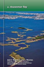
5. St. Martin River - The Coastal Bays Program
5. St. Martin River - The Coastal Bays Program
5. St. Martin River - The Coastal Bays Program

You also want an ePaper? Increase the reach of your titles
YUMPU automatically turns print PDFs into web optimized ePapers that Google loves.
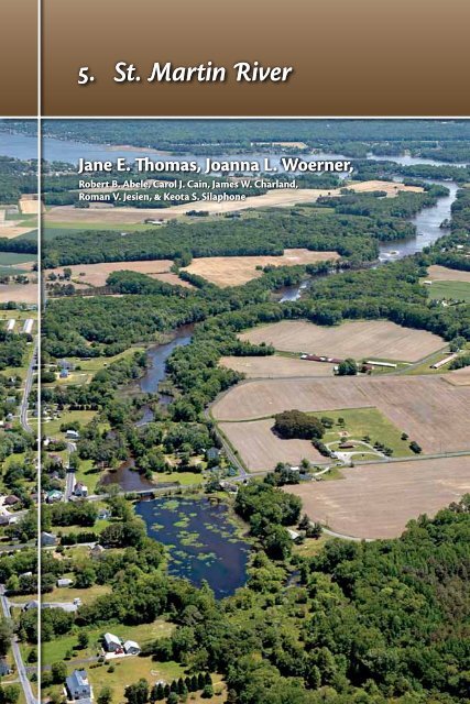
shifting sandsConclusions<strong>The</strong> ecosystem healthof <strong>St</strong>. <strong>Martin</strong> <strong>River</strong> is impacted<strong>St</strong>. <strong>Martin</strong> <strong>River</strong> ranked last in the <strong>Coastal</strong><strong>Bays</strong> for estuarine health as a result ofintensive land use (development andagriculture). It had the lowest scores forwater quality, bay benthic index, hardclam density, sediment quality, andseagrass coverage. Watershed indicatorswere marginally better with relatively lowimpervious surface. However, streamnitrate was high, and forest cover was thelowest in the <strong>Coastal</strong> <strong>Bays</strong>. This resultedin <strong>St</strong>. <strong>Martin</strong> <strong>River</strong>’s overall ecosystemhealth ranking as last of the <strong>Coastal</strong> <strong>Bays</strong>.A combination of poor flushing, heavynutrient loading from both agricultureand development, and poor managementpractices previously implementedprobably contributed to the currentimpacted health and steady decline of <strong>St</strong>.<strong>Martin</strong> <strong>River</strong>. For more information, seeChapter 2—Ecosystem Health Assessment.How healthy is <strong>St</strong>. <strong>Martin</strong> <strong>River</strong>?1.0HEALTHY6.6IMPACTED0.39<strong>St</strong>. <strong>Martin</strong> <strong>River</strong> issuesAlthough the following issues arepresented here as pertaining to <strong>St</strong>. <strong>Martin</strong><strong>River</strong>, they also apply to other <strong>Coastal</strong><strong>Bays</strong> subwatersheds.Total Maximum Daily Loads havebeen established for <strong>St</strong>. <strong>Martin</strong> <strong>River</strong><strong>The</strong> Delaware Department of NaturalResources and Environmental Control hasidentified the water quality of BuntingsBranch as impaired due to elevated3.3DEGRADED0.0Jane ThomasAerial view looking from Bishopville Prong down <strong>St</strong>. <strong>Martin</strong> <strong>River</strong> towards Isle of Wight Bay and Ocean City.90
shifting sandsDelaware will implement therequirements of its tmdl throughcooperation with the state of Marylandand development of a Pollution Control<strong>St</strong>rategy. Maryland is pursuing nutrientreductions through Watershed RestorationAction <strong>St</strong>rategies. For more informationon TMDLs, see Chapter 3—Management ofthe <strong>Coastal</strong> <strong>Bays</strong> & Watershed.Restoration of Bishopville Prongis plannedA stream and wetlands restoration projectnear the town of Bishopville is closeto the construction phase. <strong>The</strong> projectarea extends from the head of tide ofBishopville Prong to approximately2.4 km (1.5 mi) upstream and includesa dam removal and restoration of anabandoned sand mine.<strong>The</strong>re is an existing sheet pile damlocated where Route 367 (BishopvilleRoad) crosses Bishopville Prong.Originally built to create a mill pond,Bishopville Dam has been in existence, inone form or another, for over 130 years.<strong>The</strong> dam restricts the upstream movementof fish, including both seasonal spawnersBishopville Dam is at the head of Bishopville Prong,<strong>St</strong>. <strong>Martin</strong> <strong>River</strong>. This dam is the subject of a $1.7 millionrestoration project, a cooperative effort between local,state, and federal agencies to remove the existingdam, landscape the area, and restore the stream andstreamside vegetation.Roman Jesien Shih-Nan ChenAttempting to collect fish below Bishopville Dam. <strong>The</strong> dam is behind the Bishopville Road bridge.92
Chapter 5 • st. martin riverand residents. Upstream of the existing dam, BuntingsBranch has been ditched or channelized, as have nearlyall the tributaries flowing into Buntings Branch (e.g., SlabBranch, Carey Branch, Sandy Branch, Polly Branch), tohasten the movement of baseflows and stormflows (seestream corridor assessment section later in this chapter).<strong>The</strong>se alterations greatly lessened the opportunity forecological services such as water quality and habitat.<strong>The</strong> restoration site, known as Lizard Hill, was minedfor many years for sand and other aggregates but has notbeen actively mined since 2001. <strong>The</strong> mine site is triangularin shape and abutted on two sides by streams (BuntingsBranch to the southwest and an unnamed tributary tothe north). <strong>The</strong>re are numerous groundwater seeps thatemerge at the mine site and are currently conveyed offthe site and outleted to Buntings Branch by a number ofditches built by the mining company.<strong>The</strong> upper <strong>St</strong>. <strong>Martin</strong> <strong>River</strong> has been highly impactedby human activities for a long time and the quality ofthe water and the habitat available for fish and otherwildlife have suffered. <strong>The</strong> proposed project serves as anexcellent opportunity to reverse this trend by restoringareas in and adjacent to the river and providing significantimprovement to fish passage, instream habitat, waterquality, floodplain function, and the restoration of globallyrare vegetative communities such as Atlantic white-cedar(Chamaecypris thyoides) swamp. Atlantic white-cedarswamps were historically common on the DelmarvaPeninsula. This site offers a rare and unique opportunityto re-establish this type of habitat and community. Formore information, see Chapter 15—Habitats of the <strong>Coastal</strong><strong>Bays</strong> & Watershed.<strong>The</strong> project involves four separate, but integrated,activities that consist of: 1) removal of the existingdam that will maintain an off-line pond yet providefish passage and open approximately 11 km (7 mi) ofupstream fish habitat; 2) restoration of a portion of theupstream pond to a stream and floodplain corridor(approximately 150 m [500 ft] and 1.2 ha [3 acres] oftidal/non-tidal wetland); 3) restoration of the existingfloodplain above the dam to re-establish floodplain/stream hydrology and connection (16.6 ha [41 acres]);and 4) establishment of Atlantic white-cedar wetlandsand adjacent buffer in the now-abandoned mine sitewhich will include 8.1 ha (20 acres) of wetlands and6.1 ha (15 acres) of associated buffer.In an effort to spark conservation and restoration ofcritical and declining habitats in this area, the Maryland<strong>St</strong>. <strong>Martin</strong> <strong>River</strong> subwatershed supports many poultry farming operations.Jane Thomasst. martin river93
shifting sands<strong>Coastal</strong> <strong>Bays</strong> <strong>Program</strong> is partnering withthe Department of Natural Resources,Worcester County, U.S. Fish and WildlifeService, the Maryland <strong>St</strong>ate HighwayAdministration, and the NationalAquarium in Baltimore to completethe $3 million project. Construction isprojected to begin in the fall of 2009.Shoreline stabilization should utilize‘soft shoreline’ techniquesShoreline stabilization seeks to stopthe loss of land to encroaching waters.Moving water, whether through waveaction or currents, erodes adjacentuplands. <strong>St</strong>eadily encroaching water,through sea level rise or land subsidence,has the same effect. Waterfront propertyowners seek to prevent erosion whereverit occurs, or even where it looks like itmight occur.In the past, the stabilization method ofchoice was the bulkhead, a vertical wallsharply separating upland from water.Better understanding of the negativeeffects of extensive bulkheading led toincreased use of stone revetment, or riprap.Less ecologically damaging than bulkhead,riprap provides some habitat valuebut still offers only a poor connectionbetween uplands and waterways. Recentstudies indicate that ‘living shorelines’or shorelines that connect uplands towaterways via a marsh system achievewater quality benefits as well as providehabitat that can be superior to riprap.1,3,6Although no one method of shorestabilization is suitable for all situations,non-structural or hybrid shorelines thatconsist of offshore low-profile stone sillsthat protect the leading edges of marshescan be applied in a variety of locations.Effective October 1, 2008, the LivingShoreline Protection Act of 2008(Maryland House Bill 973; Chapter 304)requires that shoreline erosion controlprojects consist of non-structural or ‘soft’shoreline stabilization measures, exceptin areas designated by the MarylandDepartment of the Environment (MDE)as appropriate for structural or ‘hard’Jane ThomasThis vast green expanse is the Great Cypress Swamp in Delaware, the very eastern edge of which (in theforeground) is in the <strong>St</strong>. <strong>Martin</strong> <strong>River</strong> subwatershed. This photo is looking west, with Route 113 and the westernedge of Selbyville in the foreground.94
Chapter 5 • st. martin riverJane ThomasAerial view looking towards the mouth of <strong>St</strong>. <strong>Martin</strong> <strong>River</strong>. Fenwick Island is in the background.stabilization measures (bulkheads, riprap,etc.) or in areas where a person candemonstrate to MDE’s satisfaction that nonstructuralmeasures are not feasible.<strong>The</strong> future of the <strong>Coastal</strong> <strong>Bays</strong> ashabitat and destination for wildlife, fish,and anglers depends to a large extent onthe protection of the remaining naturalshoreline. New policies and techniquesneed to be applied in the <strong>Coastal</strong> <strong>Bays</strong>which will stem the loss of waterfrontland while maintaining a harmony withnature. Projects that create or restorefringe marsh, placing hard structuresoffshore instead of on land, or coveringbare ground with vegetation can slowor stop a receding shoreline. Restrictingshoreline stabilization to cases whereerosion actually occurs is anotherpotential reform.MDE will release new guidance andregulatory changes in 2008–2009 for useof natural shoreline stabilization practicesas the preferred approach for shorelinestabilization. For more information, seeChapter 3—Management of the <strong>Coastal</strong><strong>Bays</strong> & Watershed.<strong>St</strong>ream corridor assessmentidentified potential problemsIn 2001, a <strong>St</strong>ream Corridor Assessment(SCA) was conducted in the <strong>St</strong>. <strong>Martin</strong><strong>River</strong> watershed.5 <strong>The</strong> SCA is a rapidoverview of the entire non-tidal streamnetwork to determine the location ofpotential environmental problems andto collect some basic habitat information.<strong>The</strong> value of these surveys is found inplacing individual stream problems intotheir watershed context and can be usedby a variety of resource managers tocooperatively plan and prioritize futurerestoration work. Results of the recentsurveys will be used in the development ofWatershed Restoration Action <strong>St</strong>rategiesfor each subwatershed of the <strong>Coastal</strong> <strong>Bays</strong>.Information on the Watershed Action<strong>St</strong>rategies can be found on the MarylandDepartment of Natural Resources’ website(www.dnr.state.md.us/watersheds/wras).During the SCA survey, potentialenvironmental problems identifiedincluded channel alterations, inadequatestream buffers, fish migration barriers,st. martin river95
shifting sandserosion sites, construction sites within thestream corridor, and trash dumping sites.Channel alterations and inadequatestream buffers were the most commonlyreported problem during this survey.Channel alterations, best described asagricultural ditches, were found to bewidespread throughout the headwaters ofthe watershed. For more information, seeChapter 15—Habitats of the <strong>Coastal</strong> <strong>Bays</strong> &Watershed.While streams in the <strong>St</strong>. <strong>Martin</strong> <strong>River</strong>watershed have been extensively altered,they were also fairly stable with erosionproblems reported in only a few locations.<strong>The</strong> low incidence of erosion problemsis due in large part to the flat terrain andlow stream slopes in the area. This resultsuggests that streams in the area may bemore amenable to manipulation thanstream in areas where the land has muchsteeper slopes and water in the streamsflows with greater force.<strong>The</strong> majority of fish migrationblockages were characterized as beingeither temporary or partial fish migrationbarriers. Most of the fish migrationblockages were also given a minor or lowseverity rating. <strong>The</strong> only exception wasat Bishopville Dam which was given asevere rating because it was interferingwith the migration of anadromous (oceanfish that breed in freshwater) fish. Plans tomodify this dam to enable fish passage aredescribed earlier in this chapter.Recommendations• Maryland <strong>Coastal</strong> <strong>Bays</strong> <strong>Program</strong>partners should continue to pursuethe Nutrient Management ActionPlan by instituting a multi-agencyworking group to target watershedneeds with funding and resources torestore and conserve sensitive areaswithin the watershed.Discharges into <strong>St</strong>. <strong>Martin</strong> <strong>River</strong>have contributedto degraded water qualityCurrently there are no point sourcedischarges into upper <strong>St</strong>. <strong>Martin</strong> <strong>River</strong>,but point sources have contributed todegraded water quality in the past andJane Thomas<strong>The</strong> former Perdue poultry processing plant on Middle Branch of Shingle Landing Prong, <strong>St</strong>. <strong>Martin</strong> <strong>River</strong>. This plantstopped production in September 2004; however, the wastewater treatment plant continued to operate for manymonths after that as the plant was cleaned and equipment removed.96
Chapter 5 • st. martin riverJane ThomasShingle Landing Prong in the <strong>St</strong>. <strong>Martin</strong> <strong>River</strong>. <strong>The</strong> Perdue Processing Facility at Showell discharged treated industrialwastewater into Church Branch, a tributary of Shingle Landing Prong.clean up has been slow. Discontinued pointsources include the Selbyville, Delaware,Wastewater Treatment Plant (WWTP), thePerdue Processing facility at Showell onShingle Landing Prong, and the BishopProcessing Company located on anunnamed tributary of Carey Branch whichflows into Bunting Branch. <strong>The</strong> SelbyvilleWWTP discharged treated effluent into PolyBranch, a tributary of Buntings Branch, butsince the new plant was constructed in 1989,effluent has been discharged into the oceanat Rehoboth, Delaware.7<strong>The</strong> Perdue poultry processing facilityat Showell discharged treated industrialwastewater into Church Branch, a tributaryof Shingle Landing Prong. Operationsceased at the facility in 2004 and buildingproposals include conversion of the facilityto treat human waste generated by residentsof proposed and existing housing unitsin the area. <strong>The</strong> Maryland <strong>Coastal</strong> <strong>Bays</strong><strong>Program</strong> is working to get the treatedhuman waste land-applied to cropland tothe west, rather than directly discharged.<strong>The</strong> Bishop Processing Company beganoperations in 1955 about 1.3 km (0.8 mi)north of Bishopville. <strong>The</strong> property drainsto an unnamed tributary of Carey Branch,which flows into Buntings Branch. <strong>The</strong>facility processed chicken offal intobone meal and usable oils, and animaland vegetable waste oils into usableproduct. <strong>The</strong> operation ceased in 1981and the property was sold. A series ofsurveys at the site from 1983 through 2000indicated high levels of iron, chromium,and arsenic, low levels of volatile organiccompounds (VOCs), such as vinylchloride, and extremely low (acidic) pHin groundwater. Surface water sampleson-site had high levels of iron, aluminum,and arsenic and slightly elevated levels oforganics and soil samples contained pcbs(polychlorinated biphenyls) as well as lowlevels of VOCs. Contaminated soil wasidentified and removed from the site anda Voluntary Cleanup <strong>Program</strong> applicationwas submitted in 2004 seeking a NoFurther Requirements Determination. <strong>The</strong>application is currently pending. For moreinformation, see www.mde.state.md.us/assets/document/brownfields/Bishop_Processing.pdf .st. martin river97
shifting sands<strong>The</strong> site is considered a ‘brownfield.’Brownfields are previously usedland parcels located in areas that areappropriate for redevelopment, butwhich have a real or perceived sitecontamination problem. Because of thecostly liability associated with wastecleanups, businesses do not want to takea chance on locating their businesses atsuch sites. With appropriate resources,MDE can undertake a variety of actionsto make these brownfield sites attractiveto new or expanding businesses. In thisway, MDE’s brownfields redevelopmentefforts help meet the needs of economicdevelopment while directing growth toappropriate areas. For more information,see www.mde.state.md.us/<strong>Program</strong>s/Land<strong>Program</strong>s/ERRP_Brownfields/bf_info/index.asp .<strong>The</strong>re is one point source discharge intolower <strong>St</strong>. <strong>Martin</strong> <strong>River</strong>—the wastewatertreatment plant at Ocean Pines. For moreinformation, see section on the wastewatertreatment plant later in this chapter.Featuresof <strong>St</strong>. <strong>Martin</strong> <strong>River</strong>& its watershedAn oyster reef was established<strong>The</strong> Assateague <strong>Coastal</strong> Trust, inpartnership with the National Oceanicand Atmospheric Administration, theMaryland <strong>Coastal</strong> <strong>Bays</strong> <strong>Program</strong>, andothers, began a project in 2000 to establisha 4-ha (10-acre) oyster reef near the mouthof <strong>St</strong>. <strong>Martin</strong> <strong>River</strong>. By 2005, the reef wasapproaching 0.8 ha (two acres) in size andwas a mixture of oyster shell, clam shell,and concrete rubble. Each summer, oneyear-oldoysters grown by participantsin the Oyster Gardening <strong>Program</strong> wereplaced on the reef. Although smallnumbers of oysters can be found inintertidal areas such as bridge abutments,riprap shorelines, and in marshes, the <strong>St</strong>.<strong>Martin</strong> <strong>River</strong> reef was the only subtidalreef in the <strong>Coastal</strong> <strong>Bays</strong>. For moreVery few oysters live in the <strong>Coastal</strong> <strong>Bays</strong>, but a fewcan be found in intertidal areas on bridge abutments,riprap, and in marshes.information on oysters, see Chapter 14—Diversity of Life in the <strong>Coastal</strong> <strong>Bays</strong>.Surveys on the <strong>St</strong>. <strong>Martin</strong> <strong>River</strong> reefinitially indicated that the oysters werealive and growing. However, in 2005, thenumber of oysters started declining. Inaddition, colonization of the reef bybenthic organisms was minimal due toheavy accumulation of sediment andmacroalgae, which suffocates organismswhen it decomposes. Low oxygenlevels in the summer of 2006 may havealso contributed to the decline of thereef ’s health. For more information,see www.actforbays.org/pages/oyster2.php?id=139_0_5_0_C .<strong>The</strong> program was discontinued in 2007due to the difficulties in placing reefmaterials and the lack of survival of theyoung oysters. Disease, sedimentation, andpoor water quality prevented success ofthis particular oyster reef; however, muchwas learned about conditions at the mouthof <strong>St</strong>. <strong>Martin</strong> <strong>River</strong>.Ocean Pines wastewater treatmentplant was expanded in 2006<strong>The</strong> planned community of Ocean Pinesopened for business in July 1968 along<strong>St</strong>. <strong>Martin</strong> <strong>River</strong> and Isle of Wight Bay. Aprivately owned sewage treatment plantwas built to serve the community, withthe effluent being discharged into thelower portion of <strong>St</strong>. <strong>Martin</strong> <strong>River</strong>. By 1987,Joan Muller. NOAA98
Chapter 5 • st. martin rivercapacity of the sewage treatment plantwas expanded to 0.5 million gallons ofwastewater per day (MGD) and WorcesterCounty undertook ownership of the plant.Another plant upgrade was completedin 1994, which brought the capacity to1.5 MGD. <strong>The</strong> treatment plant was broughtto the present capacity of 2.3 MGD in 2003and is a state-of-the-art facility, removingnitrogen to a level of three parts permillion (or 3 mg L-1), which is equal to thebest wastewater plants in Maryland.In 2008, there were more than 15,000full-time residents with approximately7,500 more summer residents. <strong>The</strong>community has its own police and firedepartments, as well as a yacht club, swimand racquet club, beach club, and golf andcountry club. Just outside Ocean Pinesis a commercial area with a wide rangeof businesses that serve the community.Initially, the treatment plant was totreat residential wastewater, but areabusinesses have requested to tie into theplant. Efforts to incorporate a larger areain the treatment plant are currently beingdebated. <strong>The</strong> debate centers on the highcost of conversion to sewer for currentresidents on septic systems. However,new businesses and developments wouldwelcome extension of the sewer line.<strong>The</strong> Ocean Pines treatment plant wasexpanded in 2006 to allow it to processup to 2.5 MGD. This design will be able toaccommodate all of Ocean Pines sewerneeds at build-out and full occupation. Anadditional 200,000 gallons of treatmentcapacity is available for the Greater OceanPines Sewer Service Area. Because ofthe extra treatment capacity, homes andbusiness within the Sewer Service Areashould be strongly encouraged to hookup to the treatment plant, rather thanto continue to rely on traditional septicsystems, and use the extra capacity toaccommodate new home construction.•<strong>The</strong> Ocean Pines community has a recently expanded sewage treatment plant that can treat up to 9.5 million liters(2.5 million gallons) of wastewater per day.Tim Carruthersst. martin river99
shifting sandsAcknowledgements<strong>The</strong> authors would like to thank RonPilling (Assateague <strong>Coastal</strong> Trust), EdytheHumphries (Delaware Department ofNatural Resources and Control), DaveWilson (Maryland <strong>Coastal</strong> <strong>Bays</strong> <strong>Program</strong>),and Sherm Garrison and Kevin Smith(Maryland Department of NaturalResources) for comments helpful in thecompletion of this chapter.References1. Burke, D.G., E.W. Koch, & J.C. <strong>St</strong>evenson. 200<strong>5.</strong>Assessment of Hybrid Type Shore Erosion Control Projectsin Maryland’s Chesapeake Bay: Phases I & II. Final reportfor Chesapeake Bay Trust, Annapolis, Maryland.2. Delaware Department of Natural Resources &Environmental Control. 2004. Total Maximum DailyLoads (TMDLs) Analysis for Buntings Branch, Delaware.http://www.dnrec.state.de.us/water2000/Sections/Watershed/TMDL/tmdlinfo.htm3. Garbish, E.W., & J.L Garbish. 1994. Control of uplandbank erosion through tidal marsh construction onrestored shores: Application in the Maryland portion ofChesapeake Bay. Environmental Management 18: 677–691.4. Maryland Department of the Environment. 2002. TotalMaximum Daily Loads of Nitrogen & Phosphorus for FiveTidal Tributaries in the Northern <strong>Coastal</strong> <strong>Bays</strong> System,Worcester County, Maryland. http://www.mde.state.md.us/<strong>Program</strong>s/Water<strong>Program</strong>s/TMDL/ApprovedFinalTMDL/tmdl_ncb.asp<strong>5.</strong> Maryland Department of Natural Resources.2002. Isle of Wight <strong>St</strong>ream Corridor Assessment.http://dnrweb.dnr.state.md.us/download/bays/iow_sca.pdf6. National Research Council. 2007. Mitigating Shore Erosionon Sheltered Coasts. <strong>The</strong> National Academies Press,Washington, D.C.7. Town of Selbyville. 2002. Town of SelbyvilleComprehensive Plan. http://stateplanning.delaware.gov/comp_plans/selbyville_plan_final.pdf100