National Environmental Satellite, Data and Information Service - NOAA
National Environmental Satellite, Data and Information Service - NOAA
National Environmental Satellite, Data and Information Service - NOAA

You also want an ePaper? Increase the reach of your titles
YUMPU automatically turns print PDFs into web optimized ePapers that Google loves.
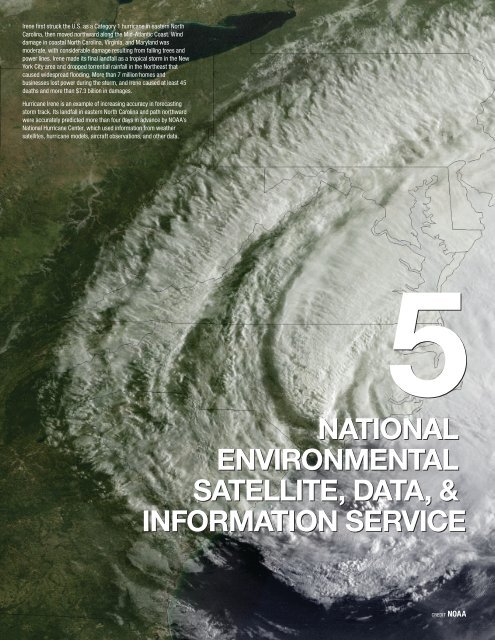
Irene first struck the U.S. as a Category 1 hurricane in eastern NorthCarolina, then moved northward along the Mid-Atlantic Coast. Winddamage in coastal North Carolina, Virginia, <strong>and</strong> Maryl<strong>and</strong> wasmoderate, with considerable damage resulting from falling trees <strong>and</strong>power lines. Irene made its final l<strong>and</strong>fall as a tropical storm in the NewYork City area <strong>and</strong> dropped torrential rainfall in the Northeast thatcaused widespread flooding. More than 7 million homes <strong>and</strong>businesses lost power during the storm, <strong>and</strong> Irene caused at least 45deaths <strong>and</strong> more than $7.3 billion in damages.Hurricane Irene is an example of increasing accuracy in forecastingstorm track. Its l<strong>and</strong>fall in eastern North Carolina <strong>and</strong> path northwardwere accurately predicted more than four days in advance by <strong>NOAA</strong>’s<strong>National</strong> Hurricane Center, which used information from weathersatellites, hurricane models, aircraft observations, <strong>and</strong> other data.NATIONALENVIRONMENTALSATELLITE, DATA, &INFORMATION SERVICECREDIT <strong>NOAA</strong>
CHAPTER 5NATIONAL ENVIRONMENTAL SATELLITE, DATA, AND INFORMATION SERVICENATIONAL ENVIRONMENTAL SATELLITE,DATA AND INFORMATION SERVICEThe <strong>National</strong> <strong>Environmental</strong> <strong>Satellite</strong>, <strong>Data</strong>, <strong>and</strong> <strong>Information</strong> <strong>Service</strong>’s(NESDIS) vision is to be the world’s most comprehensivesource <strong>and</strong> recognized authority for satellite products, environmentalinformation, <strong>and</strong> official assessments of the environment in supportof sound decision-making. NESDIS is dedicated to providingtimely access to global environmental data to enhance the Nation’seconomy, security, <strong>and</strong> quality of life. In collaboration with the <strong>National</strong>Aeronautics <strong>and</strong> Space Administration (NASA) <strong>and</strong> the U.S. AirForce, NESDIS manages <strong>and</strong> operates weather <strong>and</strong> environmentalmonitoring satellites.To fulfill its responsibilities, NESDIS acquires <strong>and</strong> operates the Nation’s operationalenvironmental satellites, manages the <strong>NOAA</strong> <strong>National</strong> <strong>Data</strong> Centers,provides data <strong>and</strong> information services, including Earth system monitoring,performs official assessments of the environment, <strong>and</strong> conducts relatedresearch. The NESDIS satellite comm<strong>and</strong> <strong>and</strong> control program acquires datafrom on-orbit U.S <strong>and</strong> international satellites 24 hours per day, 365 days peryear. This includes monitoring satellite operations, which occur at the <strong>NOAA</strong><strong>Satellite</strong> Operations Facility in Suitl<strong>and</strong>, Maryl<strong>and</strong>; satellite comm<strong>and</strong> <strong>and</strong> dataacquisition stations in Wallops, Virginia; <strong>and</strong> Fairbanks, Alaska. The Fairbanks<strong>Satellite</strong> Operations Facility (FSOF) opened in FY 2011. This state of the artfacility is farther north than any other satellite communications facility in NorthAmerica <strong>and</strong>, as a result, it receives more environmental satellite data thanany other station <strong>and</strong> is a vital link to satellites operated by <strong>NOAA</strong> <strong>and</strong> otheragencies. From these ground stations, NESDIS operates <strong>and</strong> acquires datafrom Polar-orbiting Operational <strong>Environmental</strong> <strong>Satellite</strong>s (POES), GeostationaryOperational <strong>Environmental</strong> <strong>Satellite</strong>s (GOES), the Department of Defense(DoD) Defense Meteorological <strong>Satellite</strong> Program (DMSP), <strong>and</strong> Jason-2.A Delta II rocket launches with the Suomi <strong>National</strong>Polar-orbiting Partnership (Suomi NPP) spacecraftpayload from Space Launch Complex 2 atV<strong>and</strong>enberg Air Force Base, CA. on Friday, Oct. 28,2011. Suomi NPP is the first NASA satellite missionto address the challenge of acquiring a wide rangeof l<strong>and</strong>, ocean, <strong>and</strong> atmospheric measurementsfor Earth system science while simultaneouslypreparing to address operational requirements forweather forecasting. Photo Credit: (NASA/Bill Ingalls)Using environmental satellites to observe the Earth from space is one of thekey tools in forecasting weather, analyzing climate, <strong>and</strong> monitoring hazardsworldwide. Such timely <strong>and</strong> accurate information supports the <strong>National</strong>Weather <strong>Service</strong>, Federal <strong>and</strong> state agencies, <strong>and</strong> local emergency managementagencies, enabling advance warnings of emerging severe weather suchas hurricanes, flash floods, winter storms <strong>and</strong> wild l<strong>and</strong> fires. Along with theskill of <strong>NOAA</strong> meteorologists, <strong>NOAA</strong>’s satellites are critical to the success ofour national forecasts <strong>and</strong> are the backbone of the global earth observing5-73
CHAPTER 5NATIONAL ENVIRONMENTAL SATELLITE, DATA, AND INFORMATION SERVICEFY 2012 funding support from the Consolidated <strong>and</strong> Further Continuing Appropriations Act, 2012 (P.L.112-55) provided a foundation from which <strong>NOAA</strong> could make significant progress towards developing itsnext generation polar orbiting satellite system, JPSS. Currently, there is a potential polar observational satellitedata gap from the projected end of life of the current polar mission, the Suomi <strong>National</strong> Polar-orbitingPartnership (Suomi NPP) satellite, to the beginning of the JPSS mission, <strong>and</strong> <strong>NOAA</strong> is assessing optionsto mitigate any gap in weather data.<strong>NOAA</strong> is conducting a comprehensive re-evaluation of its space-based observation requirements with agoal to maintain <strong>and</strong> acquire critical services that meet the Nation’s national environmental data needs.NESDIS will continue to pursue collaborative opportunities with other national <strong>and</strong> international agencies<strong>and</strong> organizations <strong>and</strong> partner with industry, academia, <strong>and</strong> other research <strong>and</strong> development agencies.These partnerships will bring robust information <strong>and</strong> service delivery to our customers <strong>and</strong> invest in effectiverelationships with stakeholders. In particular, NESDIS will continue participating in global partnerships,such as with the European Organisation for the Exploitation of Meteorological <strong>Satellite</strong>s (EUMETSAT), tohelp the United States <strong>and</strong> Europe provide increased capability to monitor global weather <strong>and</strong> climate.5-75
CHAPTER 5NATIONAL ENVIRONMENTAL SATELLITE, DATA, AND INFORMATION SERVICEFY 2013 ORF BUDGET SUMMARY<strong>NOAA</strong> requests a total of $191,097,000 <strong>and</strong> 669 FTEs to support NESDIS activities funded in the Operations,Research, <strong>and</strong> Facilities (ORF). This is an increase of $9,897,000 <strong>and</strong> a decrease of 9 FTEs from theFY 2012 estimate. This includes a net increase of $8,379,000 in program changes <strong>and</strong> a decrease of 9FTEs <strong>and</strong> an increase of $1,518,000 <strong>and</strong> 0 FTEs for Adjustments to Base (ATB). Adjustments include thefollowing transfers:• <strong>NOAA</strong> requests a technical adjustment to transfer the NESDIS <strong>Satellite</strong> Comm<strong>and</strong> <strong>and</strong> ControlProduct Processing <strong>and</strong> Distribution line items to the new NESDIS line item, Office of <strong>Satellite</strong> <strong>and</strong>Product Operations (OSPO). No adjustments have been made to the three PPAs, except in thealignment under this new line item.• <strong>NOAA</strong> requests a technical adjustment to rename the Regional Climate Centers PPA the RegionalClimate <strong>Service</strong>s PPA. No funding or FTE changes are associated with this request.NESDIS – ORF PROGRAM CHANGE HIGHLIGHTS FOR FY 2013:Select program changes (generally above $500,000) are highlighted below at the sub-activity level. Asummary of funding by Program, Project <strong>and</strong> Activity (PPA) is located in Chapter 9, Appendices. Detaileddescriptions of all program changes by PPA are located in the <strong>NOAA</strong> FY 2013 Congressional Justification.ENVIRONMENTAL SATELLITE OBSERVING SYSTEMS $123,199,000<strong>NOAA</strong> requests an increase of $9,679,000 <strong>and</strong> 0 FTEs for a total of $123,199,000 <strong>and</strong> 409 FTEs under the<strong>Environmental</strong> <strong>Satellite</strong> Observing Systems sub-activity.Office of <strong>Satellite</strong> <strong>and</strong> Product Operations: <strong>NOAA</strong> requests an increase of $9,586,000 <strong>and</strong> 0 FTEs. This iscomprised of three increases, two of which are below $500,000:Suomi-NPP artist renderingSuomi-NPP <strong>and</strong> Polar Continuity <strong>Data</strong> Processing <strong>and</strong> Distribution: <strong>NOAA</strong> requestsan increase of $9,435,000 <strong>and</strong> 0 FTEs to process <strong>and</strong> distribute environmental datafrom the Suomi NPP mission. The Suomi NPP satellite was successfully launched inOctober 2011. The checkout period under the <strong>National</strong> Aeronautics <strong>and</strong> Space Administration(NASA) will be completed during the seven months following the launch. The SuomiNPP satellite will provide essential continuity of polar environmental observations. TheSuomi NPP Production Environment system provides the only national link to get nearreal-time Suomi NPP data to <strong>NOAA</strong> operational centers <strong>and</strong> other <strong>NOAA</strong> partners in thecivilian user community. Funding will be used to procure a robust IT capability needed togenerate operational products on a 24 x 7 basis from Suomi-NPP that will lead to improveddaily weather forecasts <strong>and</strong> warnings, hurricane l<strong>and</strong>fall warnings, <strong>and</strong> harmful algal bloomassessments, which have the potential to mitigate economic losses.<strong>NOAA</strong>’S DATA CENTERS & INFORMATION SERVICES $67,898,000<strong>NOAA</strong> requests a decrease of $1,300,000 <strong>and</strong> 9 FTEs <strong>and</strong> a total of $67,898,000 <strong>and</strong> 260 FTEs under the<strong>Data</strong> Centers & <strong>Information</strong> <strong>Service</strong>s sub-activity.5-77
NATIONAL OCEANIC AND ATMOSPHERIC ADMINISTRATIONFY 2013 BUDGET SUMMARYArchive, Access, & Assessment: <strong>NOAA</strong> requests a decrease of $552,000 <strong>and</strong> 9 FTEs. This is comprisedof one increase <strong>and</strong> three decreases.<strong>National</strong> Climatic <strong>Data</strong> Center, <strong>Data</strong> Center Operations: <strong>NOAA</strong> requests anincrease of $5,822,000 <strong>and</strong> 0 FTEs for <strong>Data</strong> Center Operations to maintain<strong>NOAA</strong>’s ability to provide long-term preservation (safe storage) <strong>and</strong> accessto the Nation’s environmental data <strong>and</strong> information. <strong>NOAA</strong>’s <strong>Data</strong> Centershave begun the transition from their legacy archive storage systems to the newEnterprise Archive system. <strong>Data</strong> Centers are being equipped to h<strong>and</strong>le exp<strong>and</strong>ingvolumes of data from satellites, weather radars, high resolution weather, ocean,<strong>and</strong> climate models, <strong>and</strong> other large volume data sets. <strong>Data</strong> Center Operations willaccommodate the storage <strong>and</strong> retrieval of these data sets. In FY 2013, funds will beused to provide operations <strong>and</strong> maintenance of <strong>NOAA</strong>’s new Enterprise Archive <strong>and</strong> Massive tape library transitioning to new EnterpriseArchive SystemAccess system <strong>and</strong> communications b<strong>and</strong>width to deliver large data volumes. Thearchive system will accommodate data from new or improved observations plannedby <strong>NOAA</strong>: Suomi-NPP, JPSS, GOES-R, <strong>and</strong> Dual Polarization-modified weather radar.In addition, funds will support facility infrastructure <strong>and</strong> Federal IT security requirementsincluding training of systems operators <strong>and</strong> administrators.<strong>National</strong> Oceanographic <strong>Data</strong> Center: <strong>NOAA</strong> requests a decrease of$3,796,000 <strong>and</strong> 6 FTEs to reduce funding to the <strong>National</strong> Oceanographic<strong>Data</strong> Center. The <strong>National</strong> Oceanographic <strong>Data</strong> Center (NODC), located in SilverSpring, MD, with offices in Stennis, MS; Honolulu, HI; San Diego, CA; <strong>and</strong> Charleston,SC, is the Nation’s permanent archive for oceanographic data, ensuring publicaccess to <strong>and</strong> the scientific stewardship (quality control, analysis <strong>and</strong> management)of long-term observational records of the global ocean, <strong>and</strong> U.S. coastal waters <strong>and</strong>their ecosystems. In FY 2013, NODC will begin to consolidate its operations, centralizing<strong>Information</strong> Technology (IT) functions in Mississippi <strong>and</strong> administrative functions Visualization Laboratory was generated from NODC’sThis image, developed by <strong>NOAA</strong> <strong>Environmental</strong>in Maryl<strong>and</strong>. The consolidation will reduce requirements for contractor support for World Ocean Atlas. It shows the long-term average seasurface temperature.IT operations. There will be a temporary decrease in the number of data sets goingonline until the NODC archive is migrated to the Comprehensive Large Array-dataStewardship System. NODC will continue to provide a permanent archive for ocean <strong>and</strong>coastal data.5-78<strong>National</strong> Geophysical <strong>Data</strong> Center: <strong>NOAA</strong> requests a decrease of $578,000<strong>and</strong> 3 FTEs to the divisions of the <strong>National</strong> Geophysical <strong>Data</strong> Center (NGDC)responsible for space weather <strong>and</strong> natural hazard data, as well as the<strong>National</strong> Snow <strong>and</strong> Ice <strong>Data</strong> Center. In FY 2013, <strong>NOAA</strong> proposes to discontinuesupport for specific sea-ice products that are developed for the NASA funded<strong>National</strong> Snow <strong>and</strong> Ice <strong>Data</strong> Center; some of these products could potentially befunded through other sources outside of NGDC or <strong>NOAA</strong>. Two FTE will be reducedfrom the NGDC division responsible for providing scientific data stewardship forthe Nation’s operational space environmental data <strong>and</strong> information; even with thisreduction NGDC maintains the ability to provide mission critical space weather datasets to support <strong>NOAA</strong>’s forecasting <strong>and</strong> monitoring abilities. An additional FTE willbe reduced from the NGDC division responsible for archiving <strong>and</strong> assimilating naturalhazard information, since funding provided by sources outside of NGDC was alreadyscheduled to decrease.The GOES-15 spacecraft carries a sophisticated SolarX-ray Imager to monitor the Sun’s X-rays for the earlydetection of solar flares, coronal mass ejections, <strong>and</strong>other phenomena that impact the geospace environment.
CHAPTER 5NATIONAL ENVIRONMENTAL SATELLITE, DATA, AND INFORMATION SERVICEClimate <strong>Data</strong>base Modernization Program: <strong>NOAA</strong> requests a decrease of$2,000,000 <strong>and</strong> 0 FTEs to terminate the Climate <strong>Data</strong>base Modernization Program(CDMP). This program scans images <strong>and</strong> keys data from paper <strong>and</strong> microfilm of newincoming <strong>and</strong> historical records <strong>and</strong> makes the digital data available on the web to businesses<strong>and</strong> members of the climate <strong>and</strong> environmental communities. The CDMP programis a partnership with four private sector contractors, currently supporting approximately35 contractor personnel. CDMP’s goal is to preserve <strong>and</strong> make available climate datagoing back several hundred years. To date, over 57 million images have been digitizedfor on-line access. Over 14 terabytes of data have been keyed <strong>and</strong> converted to digitalformat, extending the historical climate record back to the early 1800s, <strong>and</strong> in some cases,the 1700s. <strong>Environmental</strong> publications <strong>and</strong> historical documents are now available inelectronic form <strong>and</strong> can be downloaded to a computer. NWS is in the process of digitallyconverting its remaining stations that still record <strong>and</strong> report via paper, which will reduce theimmediate operational need for CDMP supported service.Coastal <strong>Data</strong> Development: <strong>NOAA</strong> requests a decrease of $500,000 <strong>and</strong> 0 FTEs toreduce funding to the <strong>National</strong> Oceanographic <strong>Data</strong> Center/<strong>National</strong> Coastal <strong>Data</strong>Development Center (NODC/NCDDC). NCDDC is located in Stennis, MS. NODC/NCDDCsupports marine environmental <strong>and</strong> ecosystems stewardship by providing access to the nation’scoastal data resources. NCDDC uses established <strong>and</strong> emerging technologies to supportend-to-end data management for <strong>NOAA</strong> <strong>and</strong> <strong>NOAA</strong>’s partners in Federal, State, local,academic, <strong>and</strong> other organizations. NCDDC focuses on the development of products <strong>and</strong>services intended to bring together scientists <strong>and</strong> coastal managers to act as an importantsource of coastal ecological <strong>and</strong> observational data <strong>and</strong> information for the American publicat large. The FY 2013 budget will reduce NODC regional project development <strong>and</strong> sciencecontractor support at the NCDDC. With increased collaboration with existing partnershipsin other agencies, NODC will continue to identify <strong>and</strong> obtain coastal data sets for ingest intothe national ocean <strong>and</strong> coastal archive.Devils Lake water level has risen over 25 feet over thelast 20 years. Devil’s Lake, N.D., July 21, 2011 --A roadthat had lead to a farm near Devil’s Lake is underwater.Devil’s Lake has been overtaking the towns surroundingthe lake, forcing local <strong>and</strong> state officials to try <strong>and</strong> stopthe l<strong>and</strong> erosion. Photo by Patsy Lynch/FEMARegional Climate <strong>Service</strong>s: <strong>NOAA</strong> requests a decrease of $1,048,000 <strong>and</strong> 0 FTEsfor Regional Climate <strong>Service</strong>s (RCS), which includes the six Regional ClimateCenters (RCCs) <strong>and</strong> the six Regional Climate <strong>Service</strong>s Directors (RCSDs). Each RCSDis located at an NWS Regional Office. They are charged with coordinating <strong>and</strong> organizingrelationships <strong>and</strong> projects within their respective region across <strong>NOAA</strong> business units,their respective regional RCC, <strong>and</strong> other non-agencies (government, private, academic,research). The RCSDs also provide oversight <strong>and</strong> direction regarding the tasks includedin the individual contracts with each RCC. Through a competitive award process, six newRCC contracts will be awarded for FY 2013. Each RCSD will directly manage the <strong>NOAA</strong>contract for a specific RCC, thereby reducing the management overhead costs under thecontract <strong>and</strong> providing improved contract oversight regarding deliverables <strong>and</strong> performancemeasures. The intent is to better align the geographical regions <strong>and</strong> area of responsibilitiesmanaged by <strong>NOAA</strong> through the RCSDs <strong>and</strong> the NWS regions. Together, the RCSDs <strong>and</strong>RCCs will serve as trans-boundary experts identifying stakeholder needs <strong>and</strong> matchingthose needs with the emerging science <strong>and</strong> observations developed through <strong>NOAA</strong>’s <strong>Data</strong>Centers, labs <strong>and</strong> partners.5-79
CHAPTER 5NATIONAL ENVIRONMENTAL SATELLITE, DATA, AND INFORMATION SERVICEsystems, continue product development, <strong>and</strong> provide technical management, maintenancesupport <strong>and</strong> operations of the on-orbit assets. The purpose of the GOES-N Series is toprovide environmental satellite continuity of the eastern <strong>and</strong> western hemispheres until theGOES-R Program launches its first satellite in FY 2016.(BA IN THOUSANDS)FY 2013REQUEST FY 2014 FY 2015 FY 2016 FY 2017GOES-R $802,000 $950,761 $844,744 $781,653 $706,251GOES-R artist renderingGOES-R: <strong>NOAA</strong> requests an increase of $186,378,000 <strong>and</strong> 0 FTEs to providecontinued satellite engineering development <strong>and</strong> production activities for theGOES-R Series (GOES-R, -S, -T, & U) that are necessary to meet a launch readinessdate (LRD) of Q1 FY 2016 for the first GOES-R satellite. The GOES-R Series willprovide continuity of GOES data coverage after the GOES-N series <strong>and</strong> will provide criticalweather observations for severe weather events such as hurricanes, <strong>and</strong> also provide keyenhancements in observational capabilities for climate, oceans <strong>and</strong> coasts, <strong>and</strong> the spaceenvironment through 2036. The procurement of GOES-R satellites <strong>and</strong> ground systems isa cooperative venture between <strong>NOAA</strong> <strong>and</strong> NASA. While <strong>NOAA</strong> defines program requirements,provides funding, <strong>and</strong> operates the GOES satellites, NASA procures <strong>and</strong> launchesthe satellites on <strong>NOAA</strong>’s behalf. In FY 2013, this planned increase will continue spacecraft<strong>and</strong> ground system development, <strong>and</strong> support integration, testing, <strong>and</strong> delivery of initialFlight Units for five instruments. FY 2013 funding will allow a ramp up of ground systemintegration <strong>and</strong> test activities, including the new antennas, <strong>and</strong> launch vehicle acquisitionactivities. These activities are critical to meeting a first quarter 2016 launch necessary tobackup the GOES-west satellite at the end of its expected life in 2017.(BA IN THOUSANDS)FY 2013REQUEST FY 2014 FY 2015 FY 2016 FY 2017Jason-3 $30,000 $40,000 $6,000 $6,000 $6,000JASON-3 artist renderingJason-3: <strong>NOAA</strong> requests an increase of $10,300,000 <strong>and</strong> 0 FTEs to continue thedevelopment of the Jason-3 satellite in partnership with EUMETSAT <strong>and</strong> CNES.The most accurate measurements of sea surface heights are made by the Jason seriesof satellites. It is critical to our underst<strong>and</strong>ing of global <strong>and</strong> regional climate variability thatwe continue to collect, analyze <strong>and</strong> maintain a continuous record of sea surface heightdata. Jason-2 continues the systematic collection of sea level observations initiated byTOPEX/Poseidon in 1992. The Jason-3 satellite will be functionally equivalent to theJason-2 satellite. The requested funds are necessary to complete development activities onthe U.S. instruments, including a microwave radiometer <strong>and</strong> precision orbit determinationcomponents (e.g., GPS). This increase is required to meet a launch date in FY 2015 to ensurethe continuity of measuring sea surface height, which is a critical climate data recordthat has been maintained for over 20 years. Funds will also continue to support launchservices <strong>and</strong> associated engineering services for Jason-3. EUMETSAT <strong>and</strong> CNES, whohave secured their funding contributions, are providing the spacecraft, altimeter, precisionorbit components, ground system, <strong>and</strong> operations. <strong>Data</strong> from Jason-3 will also be used toassist in forecasting short-term, severe weather events, including tropical cyclones.5-81
NATIONAL OCEANIC AND ATMOSPHERIC ADMINISTRATIONFY 2013 BUDGET SUMMARY(BA IN THOUSANDS)Joint Polar <strong>Satellite</strong>System (JPSS)FY 2013REQUEST FY 2014 FY 2015 FY 2016 FY 2017$916,364 $956,000 $958,628 $943,600 $921,100Joint Polar <strong>Satellite</strong> System (JPSS): <strong>NOAA</strong> requests a decrease of$33,530,000 <strong>and</strong> 0 FTEs to continue development of the JPSS instruments,ground system, <strong>and</strong> spacecraft. The FY 2013 proposed funding profile maintainsall planned weather instruments <strong>and</strong> supports a second quarter FY 2017 LaunchReadiness Date for the first JPSS satellite to minimize any gap in weather coveragebetween the Suomi NPP satellite <strong>and</strong> the launch of the first JPSS satellite. FY 2013funding is necessary to continue development of the JPSS ground system, spacecraft<strong>and</strong> instruments, including sensors for measuring ozone, earth radiation <strong>and</strong>solar irradiance. FY 2013 funding will complete the development of the Total SolarJPSS under constructionIrradiance Sensor (TSIS)- 1 <strong>and</strong> the Clouds <strong>and</strong> Earth Radiant Energy System instrument(CERES), <strong>and</strong> continue the development of the Ozone Mapping Profiler Suite-Nadir instrument (OMPS-Nadir). CERES will fly on the JPSS-1 spacecraft sustainingthe measurement from the Suomi NPP satellite. TSIS-1 cannot be accommodated on theJPSS-1 spacecraft, <strong>and</strong> <strong>NOAA</strong> <strong>and</strong> NASA are evaluating options for flying the instrument.<strong>NOAA</strong> <strong>and</strong> the Administration continue to seek cost-effective ways of implementing satellitemissions <strong>and</strong> are evaluating options to achieve a life-cycle cost of $12.9 billion or less forthe JPSS program.(BA IN THOUSANDS)Deep Space ClimateObservatory(DSCOVR)FY 2013REQUEST FY 2014 FY 2015 FY 2016 FY 2017$22,883 $19,275 $3,200 $3,200 $2,400Deep Space Climate Observatory (DSCOVR): <strong>NOAA</strong> requests a decrease of$6,917,000 <strong>and</strong> 0 FTEs to continue the refurbishment of DSCOVR, which willprovide solar wind data for geomagnetic storm warnings. Space weather hasdemonstrated the potential to disrupt significant portions of the U.S. infrastructure,including transportation systems, power grids, telecommunications, <strong>and</strong> GPS. TheNWS Space Weather Prediction Center forecasters use information derived fromNASA’s Advanced Composition Explorer (ACE) satellite to issue forecasts <strong>and</strong> warningsfor geomagnetic storms. <strong>NOAA</strong> provides these warnings to allow key industriessuch as the commercial airline, electric power, <strong>and</strong> GPS industries to prepare for <strong>and</strong>avoid the harmful effects of space weather. DSCOVR will provide the same kinds DSCOVRof measurements that ACE currently provides after its launch in FY 2014. FY 2013funds will continue the refurbishment of the NASA <strong>Satellite</strong>, DSCOVR, by the NASA/Goddard Space Flight Center (GSFC). On behalf of <strong>NOAA</strong>, NASA is conducting this workon a reimbursable basis. The U.S. Air Force (USAF) is a partner <strong>and</strong> will provide the launchvehicle <strong>and</strong> services based on funds appropriated for the USAF in the FY 2012 ConsolidatedAppropriations Act (P.L. 112-74).5-82