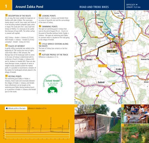
Contents & Tracks Types of difficultyKm Types of bikes Level1. Around Žabka Pond 15,5 road, trekk •2. Through the longest villages of the Hřebeč region 24,8 road, trekk •3. In Prussian artillerymen footsteps 28,2 trekk, MTB •4. In robber knights footsteps 34,4 trekk, MTB ••5. Along the Svitavy valley 36,7 road, trekk •6. The region of bishop ponds 41,3 trekk, MTB ••7. Along merchant paths 42,6 trekk, MTB ••8. Region of one-thousand-year-old history 46,1 trekk, MTB ••9. In Max Švabinský footsteps 47,6 trekk, MTB ••10. Along the region of Slavonic settlements 49,2 trekk, MTB ••11. Around ancient settlements 51,7 road, trekk ••12. To the Svojanov Watchtower 54,6 road, trekk •••13. Along old mines 57,8 trekk, MTB •••LEGEND:roadsdirt road, cart track, foot pathrailwayriver, brook, spring, water surfacerock formation, protected treeforestprotected territorychateau, castle, ruins,cultural monumentmarked cyclepaths (long distance, local), off-road bike pathbike path without markingplanned bike path14. Along Trstěnice Path 72,4 trekk, MTB •••15. Across Malá Haná 73,3 trekk, MTB •••16. To the Bystré domination 73,5 road, trekk ••••17. Around Hřebeč castles 75,4 trekk, MTB •••18. To the Barocque beauty of the Hřebeč region 97,6 trekk, MTB ••••LEVEL OF DIFFICULTYis just a point of reference• for beginner cyclists, for families with small children•• for intermediate cyclists, for families with teenagers••• for advanced cyclists, for youth groups•••• for very advanced and trained cyclistsPLACES OF INTERESTThe aim is to introduce the route from the historical point of view, to focus on places of interest andsights situated on the path or in the villages on the way. Because of easier orientation there is anumber in a bracket which belongs to sights and villages.At the end of the booklet you can find a shorthistorical annotation. Both sights and villages are lined in this appendix under appropriate numbersaccording to the alphabet. The list of villages and sights is not complete because of the lack of spacein the material.CYCLEPATHS ARE MARKED WITH YELLOW PLATESAbove mentioned tracks are suggested maximally along marked cyclepaths. In maps and altitudeprofiles these tracks are traced out with dark purple colour.Terrain cyclepaths are marked with stripe signs (see the picture). In maps and altitude profiles thetracks are marked with appropriate colours on stripe signs (red, blue, yellow)cyclepathterrain cyclepath


![ŠVP 53-41-M/01 Zdravotnický asistent [PDF] - SZŠ Svitavy](https://img.yumpu.com/36328131/1/184x260/svp-53-41-m-01-zdravotnicky-asistent-pdf-szs-svitavy.jpg?quality=85)