Vascular plant species inventory of a Philippine lowland rain forest ...
Vascular plant species inventory of a Philippine lowland rain forest ...
Vascular plant species inventory of a Philippine lowland rain forest ...

Create successful ePaper yourself
Turn your PDF publications into a flip-book with our unique Google optimized e-Paper software.
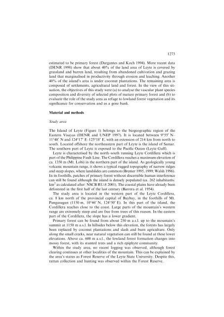
estimated to be primary <strong>forest</strong> (Dargantes and Koch 1994). More recent data(DENR 1998) show that about 40% <strong>of</strong> the land area <strong>of</strong> Leyte is covered bygrassland and barren land, resulting from abandoned cultivation and grazingland that marginalised in productivity through erosion and leaching. Another40% <strong>of</strong> the island’s area is under coconut <strong>plant</strong>ations. The remaining area iscomposed <strong>of</strong> settlements, agricultural land and <strong>forest</strong>. In the view <strong>of</strong> this situation,the objectives <strong>of</strong> this study were (a) to analyse the vascular <strong>plant</strong> <strong>species</strong>composition and diversity <strong>of</strong> selected plots <strong>of</strong> mature primary <strong>forest</strong> and (b) toevaluate the role <strong>of</strong> the study area as refuge to <strong>lowland</strong> <strong>forest</strong> vegetation and itssignificance for conservation and as a gene bank.Material and methodsStudy area1273The Island <strong>of</strong> Leyte (Figure 1) belongs to the biogeographic region <strong>of</strong> theEastern Visayas (DENR and UNEP 1997). It is located between 9°55¢ N–11°48¢ N and 124°17¢ E–125°18¢ E, with an extension <strong>of</strong> 214 km from north tosouth. Located <strong>of</strong>fshore the northeastern part <strong>of</strong> Leyte is the island <strong>of</strong> Samar.The southern part <strong>of</strong> Leyte is exposed to the Pacific Ocean (Leyte Gulf).Leyte is characterised by the north–south running Leyte Cordillera which ispart <strong>of</strong> the <strong>Philippine</strong> Fault Line. The Cordillera reaches a maximum elevation <strong>of</strong>ca. 1350 m (Mt. Lobi) in the northern part <strong>of</strong> the island. As geologically youngvolcanic mountain range, it shows a typical rugged topography <strong>of</strong> narrow ridgesand steep slopes, where landslides are common (Bremer 1995, 1999; Walsh 1996).In its foothills, patches <strong>of</strong> primary <strong>forest</strong> without discernible human interferencecan still be found although the island is densely populated (ca. 262 inhabitants/km 2 as calculated after: NSCB RU-8 2001). The coastal plains have already beende<strong>forest</strong>ed in the first half <strong>of</strong> the last century (Barrera et al. 1954).The study area is located in the western part <strong>of</strong> the Leyte Cordillera,ca. 8 km north <strong>of</strong> the provincial capital <strong>of</strong> Baybay, in the foothills <strong>of</strong> Mt.Pangasugan (1150 m, 10°46¢ N, 124°50¢ E). In this part <strong>of</strong> the island, theCordillera reaches close to the coast. Large parts <strong>of</strong> the mountain’s westernrange are extremely steep and are free from trees <strong>of</strong> this reason. In the easternpart <strong>of</strong> the Cordillera, the slope has a lower gradient.Primary <strong>forest</strong> can be found from about 250 m a.s.l. up to the mountain’ssummit at 1150 m a.s.l. In hillsides below this elevation, the <strong>forest</strong>s has largelybeen replaced by coconut <strong>plant</strong>ations and slash and burn agriculture. Onlyalong the small creeks, near natural vegetation can still be found at these lowerelevations. Above ca. 600 m a.s.l., the <strong>lowland</strong> <strong>forest</strong> formation changes intomossy <strong>forest</strong>, with its stunted trees and a rich epiphyte community.Within the study area, no recent logging was observed, although <strong>forest</strong>clearing continues at other localities <strong>of</strong> the mountain. This can be explained bythe area’s status as Forest Reserve <strong>of</strong> the Leyte State University. Despite this,rattan collection and hunting was observed within the Forest Reserve.