Assessment of flood risk in Hat Yai Municipality, Southern Thailand ...
Assessment of flood risk in Hat Yai Municipality, Southern Thailand ...
Assessment of flood risk in Hat Yai Municipality, Southern Thailand ...

You also want an ePaper? Increase the reach of your titles
YUMPU automatically turns print PDFs into web optimized ePapers that Google loves.
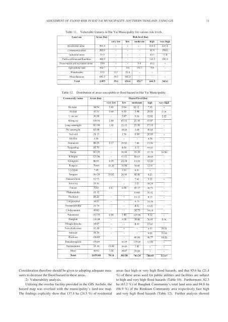
ASSESSMENT OF FLOOD RISK IN HAT YAI MUNICIPALITY, SOUTHERN THAILAND, USING GIS11Table 11.Vulnerable features <strong>in</strong> <strong>Hat</strong> <strong>Yai</strong> <strong>Municipality</strong> for various <strong>risk</strong> levels.Table 12.Distribution <strong>of</strong> areas susceptible to <strong>flood</strong> hazard <strong>in</strong> <strong>Hat</strong> <strong>Yai</strong> <strong>Municipality</strong>.Consideration therefore should be given to adopt<strong>in</strong>g adequate measuresto decrease the <strong>flood</strong> hazard <strong>in</strong> these areas.2) Vulnerability analysis.Utiliz<strong>in</strong>g the overlay facility provided <strong>in</strong> the GIS ArcInfo, thehazard map was overlaid with the municipality’s land-use map.The f<strong>in</strong>d<strong>in</strong>gs explicitly show that 137.4 ha (24.5 %) <strong>of</strong> residentialareas face high or very high <strong>flood</strong> hazards, and that 85.6 ha (21.4%) <strong>of</strong> these areas used for public utilities and facilities are subjectto high and very high <strong>flood</strong> hazards (Table 10). Furthermore, 82.3ha (63.2 %) <strong>of</strong> Banghuk Community’s total land area and 84.8 ha(66.9 %) <strong>of</strong> the Rimkuen Community area respectively face highand very high <strong>flood</strong> hazards (Table 12). Further analysis showed