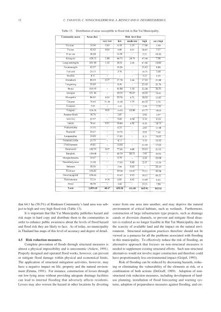
12C. TANAVUD, C. YONGCHALERMCHAI, A. BENNUI AND O. DENSREESEREKULTable 13.Distribution <strong>of</strong> areas susceptible to <strong>flood</strong> <strong>risk</strong> <strong>in</strong> <strong>Hat</strong> <strong>Yai</strong> <strong>Municipality</strong>.that 64.1 ha (50.5%) <strong>of</strong> Rimkuen Community’s land area was subjectto high and very high <strong>flood</strong> <strong>risk</strong> (Table 13).It is important that <strong>Hat</strong> <strong>Yai</strong> <strong>Municipality</strong> publishes hazard and<strong>risk</strong> maps <strong>in</strong> hard copy and distribute them to the communities <strong>in</strong>order to enhance public awareness about the levels <strong>of</strong> <strong>flood</strong> hazardand <strong>flood</strong> <strong>risk</strong> they are likely to face. As <strong>of</strong> today, no municipality<strong>in</strong> <strong>Thailand</strong> has maps <strong>of</strong> this level <strong>of</strong> accuracy and degree <strong>of</strong> detail.4.5 Risk reduction measures.Complete prevention <strong>of</strong> <strong>flood</strong>s through structural measures isalmost a physical impossibility and is uneconomic (Askew, 1991).Properly designed and operated <strong>flood</strong> works, however, can preventor mitigate <strong>flood</strong> damage with<strong>in</strong> physical and economical limits.The application <strong>of</strong> structural mitigation activities, however, mayhave a negative impact on life, property and the natural environment(Ertuna, 1991). For <strong>in</strong>stance, construction <strong>of</strong> levees throughout low-ly<strong>in</strong>g areas without provid<strong>in</strong>g adequate dra<strong>in</strong>age facilitiescan lead to <strong>in</strong>ternal <strong>flood</strong><strong>in</strong>g that adversely affects residents.Levees may also worsen the hazard <strong>in</strong> other locations by divert<strong>in</strong>gwater from one area <strong>in</strong>to another, and may deprive the naturalenvironment <strong>of</strong> critical habitats, such as wetlands. Furthermore,construction <strong>of</strong> large <strong>in</strong>frastructure type projects, such as dra<strong>in</strong>agecanals or diversion channels, to prevent and mitigate <strong>flood</strong> disastersis realized as no longer feasible <strong>in</strong> <strong>Hat</strong> <strong>Yai</strong> <strong>Municipality</strong> due tothe scarcity <strong>of</strong> available land and the impact on the natural environment.Structural mitigation practices therefore should not beviewed as a panacea for all the problems associated with <strong>flood</strong><strong>in</strong>g<strong>in</strong> this municipality. To effectively reduce the <strong>risk</strong> <strong>of</strong> <strong>flood</strong><strong>in</strong>g, analternative approach that focuses on non-structural measures isneeded to supplement exist<strong>in</strong>g structural efforts. Such non-structuralalternatives would not <strong>in</strong>volve major construction and therefore couldhave proportionately less environmental impact (Geipel, 1993).Risk <strong>of</strong> <strong>flood</strong><strong>in</strong>g can be reduced by decreas<strong>in</strong>g hazards, reduc<strong>in</strong>gor elim<strong>in</strong>at<strong>in</strong>g the vulnerability <strong>of</strong> the elements at <strong>risk</strong>, or acomb<strong>in</strong>ation <strong>of</strong> both actions (DeGraff, 1989). Adoption <strong>of</strong> nonstructural<strong>risk</strong> reduction measures, <strong>in</strong>clud<strong>in</strong>g development <strong>of</strong> landuseplann<strong>in</strong>g, <strong>in</strong>stallation <strong>of</strong> <strong>flood</strong> forecast<strong>in</strong>g and warn<strong>in</strong>g systems,adoption <strong>of</strong> preparedness measures aga<strong>in</strong>st <strong>flood</strong><strong>in</strong>g, and cre-
ASSESSMENT OF FLOOD RISK IN HAT YAI MUNICIPALITY, SOUTHERN THAILAND, USING GIS13ation <strong>of</strong> <strong>risk</strong>-transfer <strong>in</strong>struments, such as <strong>in</strong>surance, <strong>in</strong> <strong>flood</strong> <strong>risk</strong>areas can effectively reduce the effect <strong>of</strong> <strong>flood</strong><strong>in</strong>g on lives andproperty. Application <strong>of</strong> land-use plann<strong>in</strong>g can reduce <strong>flood</strong> hazardsby allocat<strong>in</strong>g less vulnerable land uses to the most hazardousareas or by avoid<strong>in</strong>g development <strong>in</strong> those locations. Relocation <strong>of</strong>the residents <strong>of</strong> high <strong>risk</strong> areas would reduce their vulnerability.Creation <strong>of</strong> a “culture <strong>of</strong> safety” <strong>in</strong> <strong>flood</strong>-prone areas also couldreduce a <strong>flood</strong>-effected community’s vulnerability by creat<strong>in</strong>g people’sawareness <strong>of</strong> possible <strong>flood</strong><strong>in</strong>g or by the build<strong>in</strong>g <strong>of</strong> saferhous<strong>in</strong>g that will withstand <strong>flood</strong><strong>in</strong>g <strong>in</strong> areas vulnerable to future<strong>flood</strong> damage. The design and <strong>in</strong>stallation <strong>of</strong> <strong>flood</strong>-forecast<strong>in</strong>g and-warn<strong>in</strong>g systems which allow people <strong>in</strong> high <strong>risk</strong> areas to move toless hazardous locations dur<strong>in</strong>g <strong>flood</strong><strong>in</strong>g can effectively reduce theelements at <strong>risk</strong>. Local preparedness to cope with potential disastersalso would effectively reduce loss <strong>of</strong> life and damage to property<strong>in</strong> high <strong>risk</strong> areas. Introduction <strong>of</strong> <strong>in</strong>surance to spread thelosses <strong>of</strong> future <strong>flood</strong>s among those directly affected also could beused to reduce <strong>risk</strong> <strong>of</strong> future <strong>flood</strong>s.Several environmental management measures could also beimplemented to reduce the <strong>flood</strong> disaster <strong>risk</strong> (United Nations,2002). For <strong>in</strong>stance, ma<strong>in</strong>tenance <strong>of</strong> the environmental and ecologicalstability <strong>of</strong> the upland watershed through the enrichment <strong>of</strong>forest cover to restore its <strong>flood</strong> protection values, prevention <strong>of</strong>encroachment by cultivators to ma<strong>in</strong>ta<strong>in</strong> a resilient environment toavert future disaster, and adoption <strong>of</strong> soil and water conservationmeasures <strong>in</strong> upland cultivation to reverse environmental degradation,can be used to reduce <strong>flood</strong> hazards. To enhance the naturalresilience to future <strong>flood</strong>s, the bas<strong>in</strong>’s headwater source areasshould be demarcated for further enhancement <strong>of</strong> the forest environment.Wetland functions, particularly water storage, should berehabilitated and conserved to absorb the impact <strong>of</strong> <strong>flood</strong><strong>in</strong>g.Prevention <strong>of</strong> dra<strong>in</strong>age congestion by remov<strong>in</strong>g soil sediment,debris, and weeds that block stream channels also is an environmentalaction that reduces vulnerability. In addition, <strong>flood</strong> <strong>risk</strong>assessment should be <strong>in</strong>corporated <strong>in</strong> the requirements <strong>of</strong> theEnvironmental Impact <strong>Assessment</strong> (EIA). An expanded EIAprocess would provide the basis to ensure that all proposed <strong>in</strong>itiativeswould <strong>in</strong>clude considerations both <strong>of</strong> vulnerability reductionand lessen<strong>in</strong>g the environmental impact. It is anticipated that theadoption <strong>of</strong> non-structural <strong>risk</strong> reduction measures and the <strong>in</strong>corporation<strong>of</strong> environmental dimensions <strong>in</strong>to <strong>risk</strong> reduction schemeswould enable <strong>Hat</strong> <strong>Yai</strong> <strong>Municipality</strong> to become more resilient to theeffects <strong>of</strong> <strong>flood</strong> hazards and support susta<strong>in</strong>able development both<strong>in</strong> the municipality and southern <strong>Thailand</strong>.5. CONCLUSIONS AND RECOMMENDATIONSDue to geographical characteristics, unplanned urbanizationand deforestation <strong>in</strong> the upland watershed, <strong>Hat</strong> <strong>Yai</strong> <strong>Municipality</strong>has a high level <strong>of</strong> <strong>flood</strong> <strong>risk</strong>. Flood<strong>in</strong>g has become a regular phenomenonand cont<strong>in</strong>ues to threaten the vulnerable social and economic<strong>in</strong>frastructure <strong>of</strong> the municipality. Extreme <strong>flood</strong> eventshave had devastat<strong>in</strong>g effects on the standard <strong>of</strong> liv<strong>in</strong>g <strong>of</strong> the populationand on development prospects. In attempts to prevent andmitigate catastrophic <strong>flood</strong><strong>in</strong>g, considerable mitigation works havebeen undertaken <strong>in</strong> <strong>Hat</strong> <strong>Yai</strong> <strong>Municipality</strong>, most <strong>of</strong> them structural.The <strong>flood</strong><strong>in</strong>g <strong>of</strong> 10 December 2003, however, demonstrated thatthese structural measures undertaken so far are not adequate towithstand <strong>flood</strong> threats. Recogniz<strong>in</strong>g the frequency and <strong>in</strong>creasedseverity <strong>of</strong> <strong>flood</strong><strong>in</strong>g <strong>in</strong> this municipality, non-structural alternativesto reduce <strong>flood</strong> <strong>risk</strong>s need to be promoted to supplement exist<strong>in</strong>gstructural <strong>in</strong>vestments. Therefore, it is recommended that <strong>Hat</strong> <strong>Yai</strong><strong>Municipality</strong> adopt the follow<strong>in</strong>g non-structural actions as a matter<strong>of</strong> priority to strengthen and improve its ability to better respond t<strong>of</strong>lood <strong>risk</strong>s:1) Set up a <strong>Hat</strong> <strong>Yai</strong> Disaster Management Authority (HYDMA).The authority, chaired by the Songkla Governor, should comprisea body made up <strong>of</strong> representatives from concerned governmentagencies, experts, academics, NGOs and local residents.The authority would propose, for approval, policies andmeasures for <strong>flood</strong> disasters. An annual meet<strong>in</strong>g <strong>of</strong> the authoritywould be held before the ra<strong>in</strong>y season to study and reviewthe progress <strong>of</strong> measures based on up-to-date <strong>in</strong>formation, tocheck operational read<strong>in</strong>ess for potential <strong>flood</strong> disasters, and toprepare proper measures and action plans. The authority wouldalso be responsible for manag<strong>in</strong>g and coord<strong>in</strong>at<strong>in</strong>g responsesand relief measures dur<strong>in</strong>g <strong>flood</strong><strong>in</strong>g.2) Raise the awareness <strong>of</strong> the municipality’s residents. They needto be aware <strong>of</strong> the natural hazards likely to be faced, what specificpreparations need to be made before an event, what to dodur<strong>in</strong>g the event, and what actions to take <strong>in</strong> its aftermath.Brochures, posters, calendars, and public service announcementson radio and television should be used to stimulate publicawareness.3) Improve the forecast<strong>in</strong>g and warn<strong>in</strong>g systems. Notice <strong>of</strong> animpend<strong>in</strong>g <strong>flood</strong> disaster issued well <strong>in</strong> advance can protectlives and property. Prediction accuracy and lead times thereforeshould be improved through the application <strong>of</strong> such state<strong>of</strong>-the-artscience and technology as radar and weather satellite<strong>in</strong>formation. Concerted effort is also needed to improve socialand organizational abilities to dissem<strong>in</strong>ate warn<strong>in</strong>gs.4) Undertake research on disaster-related topics. Even though theprediction capability for <strong>flood</strong> hazards <strong>in</strong> the Khlong U–TaphaoBas<strong>in</strong>, <strong>in</strong> which <strong>Hat</strong> <strong>Yai</strong> <strong>Municipality</strong> is located, have <strong>in</strong>creasedsignificantly, further research and modernization <strong>of</strong> weatherprediction facilities are required to provide the accuracy andlead time critical to decision makers who need to activate evacuationplans. Application <strong>of</strong> advance techniques <strong>in</strong> soilphysics, geotechnical eng<strong>in</strong>eer<strong>in</strong>g, GIS and remote sens<strong>in</strong>g for<strong>flood</strong> <strong>risk</strong> assessment and reduction also are needed. Researchshould be accelerated to determ<strong>in</strong>e what the detrimentalimpacts <strong>of</strong> <strong>flood</strong> disasters are on human health and the naturalenvironment.ACKNOWLEDGEMENTSThis work was funded by USAID as part <strong>of</strong> the <strong>Thailand</strong>Urban Disaster Mitigation Project, implemented by the ADPC.We express our s<strong>in</strong>cere thanks to <strong>Hat</strong> <strong>Yai</strong> <strong>Municipality</strong>, theDepartment <strong>of</strong> Public Works and Town and Country Plann<strong>in</strong>g, theDepartment <strong>of</strong> Land Development, and Songkla Prov<strong>in</strong>ce for theirsupport and cooperation. The constructive criticism and <strong>in</strong>sightfulcomments made on an earlier draft <strong>of</strong> this manuscript by twoanonymous referees are greatly appreciated. We hope that thisstudy will help to further the progress <strong>of</strong> disaster management <strong>in</strong>southern <strong>Thailand</strong>.