Liberty Hall - Denbighshire Countryside Service
Liberty Hall - Denbighshire Countryside Service
Liberty Hall - Denbighshire Countryside Service

Create successful ePaper yourself
Turn your PDF publications into a flip-book with our unique Google optimized e-Paper software.
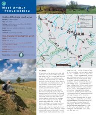
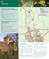
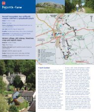
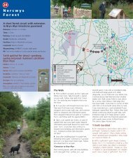
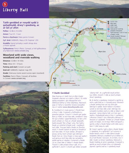
5<strong>Liberty</strong> <strong>Hall</strong>Taith gerdded ar rosydd sydd agolygfeydd, drwy'r goedwig, acar lan yr afonPellter: 12.8km / 8 milltirAmser: Tua 4.5 - 5 awrParcio a chychwyn: Maes parcio CorwenCyf. Grid: SJ080435, Map yr OS 'Explorer' 255Graddfa: Egniol (ychydig o waith dringo drosy rhostir agored)Cyfleusterau: Parry's Plaice, Cynwyd; yr holl gyfleusterauyng Nghorwen www.corwen.orgMoorland with wide views,woodland and riverside walkingDistance: 12.8km / 8 milesTime: Allow 4.5 - 5 hoursParking and start: Corwen car parkGrid ref: SJ080435, Explorer map 255Grade: Strenuous (some ascent across open moorland)Facilities: Parry's Plaice, Cynwyd; all facilitiesin Corwen www.corwen.org
<strong>Liberty</strong> <strong>Hall</strong>Dilynwch y llwybr llydan i chwarel fechan ar eichllaw dde ac i gyffordd. Cymerwch yr ail ar ychwith (peidiwch â mynd drwy'r rhwystr metalna dringo) gan ddal i ddilyn Llwybr Gogledd yBerwyn. Dilynwch y llwybr llydan ar i lawr iymuno â'r ffordd ac yna ymlaen ar y ffordd yrholl ffordd i mewn i Gynwyd. Ar y gyffordd yngnghanol y pentref, trowch i'r dde a cherddwchar y ffordd fawr.4. Ar ôl mynd heibio'r tŷ olaf ar y llaw chwith,trowch i'r chwith i lwybr troed ac arno arwyddCorwen. Ar ben y llwybr llydan, croeswch y gamfaa dilyn y llwybr sydd o'ch blaen gan gadw'r henwrych bylchog ar eich llaw chwith. Croeswchgamfa arall yn ymyl y giât ac yna trowch i'r dde acherdded ar hyd yr hen lein. Ewch drwy'r giâtsydd wrth y tŷ ac ymlaen ar hyd yr hen lein gangadw'r afon ar eich llaw chwith a chan fyndheibio eglwys Llangar ar y dde a chuddfan adar agrëwyd o hen gwt rheilffordd. Croeswch y gamfai ardd y tŷ gwyn a dilyn y llwybr dros y lawnt gangadw yn ymyl yr afon. Croeswch y gamfa yn ygornel chwith ar derfyn y lawnt gan ymuno â'rllwybr llydan o'ch blaen. Ar ôl 100m, trowch i'rchwith i lwybr ag arno arwydd, ewch drwy'r coed,dringo'r gamfa ac i'r ffordd. Croeswch y fforddfawr yn ofalus a cherdded i'r dde ar y pafin ganddilyn yr arwydd i mewn i Gorwen. Ewch iganol y dref a throi i'r chwith wrth y cerflunac i'r maes parcio.The WalkPart of this walk follows the North Berwyn Way, a24km / 15 mile waymarked route that exploresthe southern side of the Dee Valley. Pick up acopy of the booklet from Llangollen TIC ordownload from www.deevalleywalks.com1. From the car park walk to the High Street andturn right. Cross the main road at the pelicancrossing. Turn left off the High Street walking tothe left of HSBC Bank up a narrow lane. Pass thewhite Bethesda chapel. At the top of the lane,continue uphill on a grassy track, signed Pen yPigyn. Where this path meets another bear right.At path fork bear left, (note the Gorsedd stonecircle to the right) and soon after climb stonesteps. Continue climbing on this path, going upmore steps with a stonewall on the right, untilyou reach the viewpoint and monument. Take thenarrow path right and follow to a track. Turnright onto the track and go through a gateway.At T junction turn left, signed <strong>Liberty</strong> <strong>Hall</strong>. At thenext junction, after about 100m, turn right andcontinue through the forest2. At the forest edge cross the stile beside metalgate onto the moorland. Follow the clear windingpath through the heather for about 2km climbingsteadily, passing a first ruin and continuing toclimb until you reach another ruin on a higherplateau on the right. This is <strong>Liberty</strong> <strong>Hall</strong>, a disusedshooting lodge. (Wide views of Snowdonia to thewest, the Clwydian Range to the south and theBerwyns to the east and north.) Continue on thetrack ahead. After about 700m cross a stile thenfollow the track as it curves right downhill.Continue bearing right downhill towards a gate.3. Cross gate/stile and follow track into the forest.At a T junction with a wider forest track turn right,joining the North Berwyn Way (that you nowfollow all the way back to Corwen). After 50mturn right onto a narrow natural path through theforest. Follow this winding path to a stile at theforest edge. Cross stile then continue ahead acrossrough grassland to cross a second stile back intothe forest. Follow the track to a small quarry onthe right and a track junction. Take the second left(do not go uphill through metal barrier) stillfollowing the North Berwyn Way. Follow the trackdown to join a road and continue ahead on theroad all the way into Cynwyd. At the roadjunction in the village centre turn right along themain road.4. Just beyond the last houses on the left take thefootpath left, signposted Corwen. At the end ofthe track cross the stile and follow the path aheadkeeping the old hedge on the left. Cross anotherstile beside a gate then turn right and walk alongthe old railway line. Go through a gate beside ahouse and continue along the old railway line withthe river on your left, passing the white Llangarchurch on the right and a birdhide converted froman old railway hut. Cross a stile into the groundsof a riverside house and follow the path across thelawn keeping close to the river. Cross the stile inthe left corner of the fence at the end of the lawnand join the track ahead. After 50m turn left ontoa waymarked path through trees to the road.Go over stile and carefully cross the main roadand walk along the pavement, following the roadsign to Corwen. Walk into the town centre andturn left back to the car park.Grugiar goch / Red GrouseGrugieir ar y mynyddRhan o Stad y Rhug yw'r mynydd. Am dros ddwy ganrifcafodd y rhostir ei reoli ar gyfer saethu adar, a bu hynyn gymorth i gynnal y rhostir agored a'r grug sy morbwysig i'r bywyd gwyllt. Mae rhesi o guddfannau saethua wnaed o gerrig a thyweirch wedi'u cuddio o dan ygrug. Codwyd y rhain yn gysgod i'r saethwyr tra roeddy curwyr a'u cŵn yn gyrru'r grugieir tuag atynt.Adeiladwyd <strong>Liberty</strong> <strong>Hall</strong> yn gwt saethu gan yrArglwydd Newborough yn gynnar yn yr 20fed ganrif ermwyn manteisio ar y golygfeydd syfrdanol. Cludwyd yrymwelwyr o Gynwyd, ond roedd y cwt mewn lle moranghysbell ac yn anodd ei drin fel na chafodd eiddefnyddio'n hir. Defnyddiwyd yr hen adeilad gany Gwarchodlu Cartref yn ystod yr Ail Ryfel Byd i wylioam awyrennau.A Grouse MoorThe moorland is part of Rhug Estate and has beenmanaged for game shooting for over 200 years.This has helped to maintain the open heather moorlandthat is so valuable for wildlife. Hidden beneath theheather are rows of stone and turf grouse butts, built tohide and give shelter to the shooting party whilst thebeaters and their dogs drove the grouse towards them.<strong>Liberty</strong> <strong>Hall</strong> was built as a shooting lodge byLord Newborough in the early 20th century to takeadvantage of the stunning views. Guests were driven upfrom Cynwyd but the lodge was remote and difficult toservice and it was short-lived. The derelict building wasput to use as a lookout by the Home Guard duringWorld War II.23