Global Geodetic Observing System - GGOS Portal
Global Geodetic Observing System - GGOS Portal
Global Geodetic Observing System - GGOS Portal
Create successful ePaper yourself
Turn your PDF publications into a flip-book with our unique Google optimized e-Paper software.
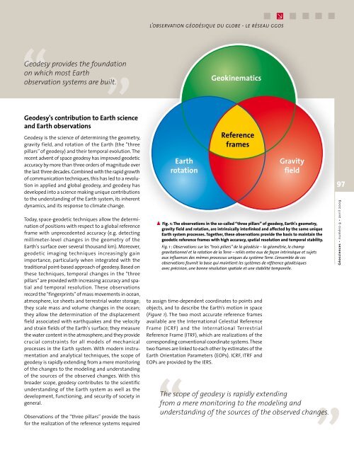
l’observation géodésique du globe - le réseau ggosGeodesy provides the foundationon which most Earthobservation systems are built.Geodesy's contribution to Earth scienceand Earth observationsGeodesy is the science of determining the geometry,gravity field, and rotation of the Earth (the “threepillars” of geodesy) and their temporal evolution. Therecent advent of space geodesy has improved geodeticaccuracy by more than three orders of magnitude overthe last three decades. Combined with the rapid growthof communication techniques, this has led to a revolutionin applied and global geodesy, and geodesy hasdeveloped into a science making unique contributionsto the understanding of the Earth system, its inherentdynamics, and its response to climate change.Today, space-geodetic techniques allow the determinationof positions with respect to a global referenceframe with unprecedented accuracy (e.g. detectingmillimeter-level changes in the geometry of theEarth's surface over several thousand km). Moreover,geodetic imaging techniques increasingly gainimportance, particularly when integrated with thetraditional point-based approach of geodesy. Based onthese techniques, temporal changes in the “threepillars” are provided with increasing accuracy and spatialand temporal resolution. These observationsrecord the “fingerprints” of mass movements in ocean,atmosphere, ice sheets and terrestrial water storage;they scale mass and volume changes in the ocean;they allow the determination of the displacementfield associated with earthquakes and the velocityand strain fields of the Earth's surface; they measurethe water content in the atmosphere; and they providecrucial constraints for all models of mechanicalprocesses in the Earth system. With modern instrumentationand analytical techniques, the scope ofgeodesy is rapidly extending from a mere monitoringof the changes to the modeling and understandingof the sources of the observed changes. With thisbroader scope, geodesy contributes to the scientificunderstanding of the Earth system as well as thedevelopment, functioning, and security of society ingeneral.Observations of the “three pillars” provide the basisfor the realization of the reference systems requiredto assign time-dependent coordinates to points andobjects, and to describe the Earth’s motion in space(Figure 1). The two most accurate reference framesavailable are the International Celestial ReferenceFrame (ICRF) and the International TerrestrialReference Frame (ITRF), which are realizations of thecorresponding conventional coordinate systems. Thesetwo frames are linked to each other by estimates of theEarth Orientation Parameters (EOPs). ICRF, ITRF andEOPs are provided by the IERS.Fig. 1: The observations in the so-called “three pillars” of geodesy, Earth's geometry,gravity field and rotation, are intrinsically interlinked and affected by the same uniqueEarth system processes. Together, these observations provide the basis to maintain thegeodetic reference frames with high accuracy, spatial resolution and temporal stability.Fig. 1 : Observations sur les “trois piliers” de la géodésie – la géométrie, le champgravitationnel et la rotation de la Terre – reliés entre eux de façon intrinsèque et sujetsaux influences des mêmes processus uniques du système Terre. L’ensemble de cesobservations fournit la base qui maintient les systèmes de référence géodésiquesavec précision, une bonne résolution spatiale et une stabilité temporelle.The scope of geodesy is rapidly extendingfrom a mere monitoring to the modeling andunderstanding of the sources of the observed changes.97Géosciences • numéro 9 • avril 2009


