Global Geodetic Observing System - GGOS Portal
Global Geodetic Observing System - GGOS Portal
Global Geodetic Observing System - GGOS Portal

Create successful ePaper yourself
Turn your PDF publications into a flip-book with our unique Google optimized e-Paper software.
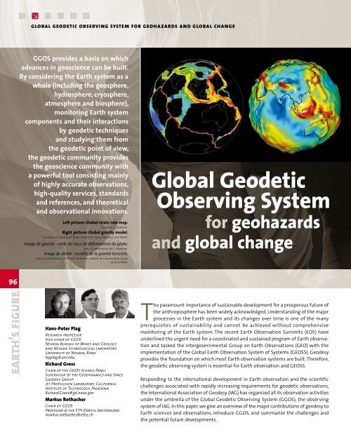
global geodetic observing system for geohazards and global change<strong>GGOS</strong> provides a basis on whichadvances in geoscience can be built.By considering the Earth system as awhole (including the geosphere,hydrosphere, cryosphere,atmosphere and biosphere),monitoring Earth systemcomponents and their interactionsby geodetic techniquesand studying them fromthe geodetic point of view,the geodetic community providesthe geoscience community witha powerful tool consisting mainlyof highly accurate observations,high-quality services, standardsand references, and theoreticaland observational innovations.Left picture: <strong>Global</strong> strain rate map.Courtesy C. Kreemer.Right picture: <strong>Global</strong> gravity model.Courtesy University of Texas Center for Space Resarch and NASA.Image de gauche : carte du taux de déformation du globe.Avec la permission de C. Kreemer.Image de droite : modèle de la gravité terrestre.Avec la permission du Centre de recherche spatiale de l’université du Texaset de la NASA.<strong>Global</strong> <strong>Geodetic</strong><strong>Observing</strong> <strong>System</strong>for geohazardsand global change96earth’s figureHans-Peter PlagResearch professorVice-chair of <strong>GGOS</strong>Nevada Bureau of Mines and Geologyand Nevada Seismological Laboratory,University of Nevada, Renohpplag@unr.eduRichard GrossChair of the <strong>GGOS</strong> Science PanelSupervisor of the Geodynamics and SpaceGeodesy GroupJet Propulsion Laboratory, CaliforniaInstitute of Technology, PasadenaRichard.Gross@jpl.nasa.govMarkus RothacherChair of <strong>GGOS</strong>Professor at the ETH Zürich, Switzerlandmarkus.rothacher@ethz.chThe paramount importance of sustainable development for a prosperous future ofthe anthroposphere has been widely acknowledged. Understanding of the majorprocesses in the Earth system and its changes over time is one of the manyprerequisites of sustainability and cannot be achieved without comprehensivemonitoring of the Earth system. The recent Earth Observation Summits (EOS) haveunderlined the urgent need for a coordinated and sustained program of Earth observationand tasked the intergovernmental Group on Earth Observations (GEO) with theimplementation of the <strong>Global</strong> Earth Observation <strong>System</strong> of <strong>System</strong>s (GEOSS). Geodesyprovides the foundation on which most Earth observation systems are built. Therefore,the geodetic observing system is essential for Earth observation and GEOSS.Responding to the international development in Earth observation and the scientificchallenges associated with rapidly increasing requirements for geodetic observations,the International Association of Geodesy (IAG) has organized all its observation activitiesunder the umbrella of the <strong>Global</strong> <strong>Geodetic</strong> <strong>Observing</strong> <strong>System</strong> (<strong>GGOS</strong>), the observingsystem of IAG. In this paper, we give an overview of the major contributions of geodesy toEarth sciences and observations, introduce <strong>GGOS</strong>, and summarize the challenges andthe potential future developments.
l’observation géodésique du globe - le réseau ggosGeodesy provides the foundationon which most Earthobservation systems are built.Geodesy's contribution to Earth scienceand Earth observationsGeodesy is the science of determining the geometry,gravity field, and rotation of the Earth (the “threepillars” of geodesy) and their temporal evolution. Therecent advent of space geodesy has improved geodeticaccuracy by more than three orders of magnitude overthe last three decades. Combined with the rapid growthof communication techniques, this has led to a revolutionin applied and global geodesy, and geodesy hasdeveloped into a science making unique contributionsto the understanding of the Earth system, its inherentdynamics, and its response to climate change.Today, space-geodetic techniques allow the determinationof positions with respect to a global referenceframe with unprecedented accuracy (e.g. detectingmillimeter-level changes in the geometry of theEarth's surface over several thousand km). Moreover,geodetic imaging techniques increasingly gainimportance, particularly when integrated with thetraditional point-based approach of geodesy. Based onthese techniques, temporal changes in the “threepillars” are provided with increasing accuracy and spatialand temporal resolution. These observationsrecord the “fingerprints” of mass movements in ocean,atmosphere, ice sheets and terrestrial water storage;they scale mass and volume changes in the ocean;they allow the determination of the displacementfield associated with earthquakes and the velocityand strain fields of the Earth's surface; they measurethe water content in the atmosphere; and they providecrucial constraints for all models of mechanicalprocesses in the Earth system. With modern instrumentationand analytical techniques, the scope ofgeodesy is rapidly extending from a mere monitoringof the changes to the modeling and understandingof the sources of the observed changes. With thisbroader scope, geodesy contributes to the scientificunderstanding of the Earth system as well as thedevelopment, functioning, and security of society ingeneral.Observations of the “three pillars” provide the basisfor the realization of the reference systems requiredto assign time-dependent coordinates to points andobjects, and to describe the Earth’s motion in space(Figure 1). The two most accurate reference framesavailable are the International Celestial ReferenceFrame (ICRF) and the International TerrestrialReference Frame (ITRF), which are realizations of thecorresponding conventional coordinate systems. Thesetwo frames are linked to each other by estimates of theEarth Orientation Parameters (EOPs). ICRF, ITRF andEOPs are provided by the IERS.Fig. 1: The observations in the so-called “three pillars” of geodesy, Earth's geometry,gravity field and rotation, are intrinsically interlinked and affected by the same uniqueEarth system processes. Together, these observations provide the basis to maintain thegeodetic reference frames with high accuracy, spatial resolution and temporal stability.Fig. 1 : Observations sur les “trois piliers” de la géodésie – la géométrie, le champgravitationnel et la rotation de la Terre – reliés entre eux de façon intrinsèque et sujetsaux influences des mêmes processus uniques du système Terre. L’ensemble de cesobservations fournit la base qui maintient les systèmes de référence géodésiquesavec précision, une bonne résolution spatiale et une stabilité temporelle.The scope of geodesy is rapidly extendingfrom a mere monitoring to the modeling andunderstanding of the sources of the observed changes.97Géosciences • numéro 9 • avril 2009
global geodetic observing system for geohazards and global change98The global geodetic networks provide continuousmonitoring of the ITRF. This well-defined, long-termstable, highly accurate and easily accessible referenceframe is the basis for all precise positioning on andnear the Earth's surface. The ITRF underpins allgeo-referenced data serving society in many ways. TheGNSS provide access to precise point coordinates inthe ITRF anytime and anywhere on the Earth's surface,with centimeter-level accuracy and without additionalmeasurements on nearby reference points. On theuser side, this technological development has stimulatednew applications demanding even greateraccuracy and better access to geodetically determinedpositions.In support of scientific applications the observationsof the global geodetic networks of the last ~15 yearshave been used to determine improved models of thesecular horizontal velocity and strain fields (Figure 2),to derive seasonal variations in the terrestrial hydrosphere,to study seasonal loading, to invert for massmotion, to improve the modeling of the seasonal termin polar motion and to detect surface deformationsassociated with volcanoes, earthquakes, fault motion, orsubsidence caused by anthropogenic activities such asgroundwater extraction (see Plag & Pearlman, 2009).Variations in Earth's rotation reflect mass transport inthe Earth system and the exchange of angularmomentum among its components. Earth rotationobservations have provided insight into many globalscaledynamic phenomena such as the El Niño/SouthernOscillation (ENSO), the most prominent feature of theclimate system on inter-annual time scales. During anENSO event, the tropical easterlies collapse causingFig. 2: Horizontalvelocity fields atthe Earth's surfacederived fromgeodeticobservations.Fig. 2 : Champsde vitesse horizontaleà la surface de la Terreobtenus à partird’observationsgéodésiques.Source : http://sideshow.jpl.nasa.gov/mbh/series.html
Fig. 3: Improvement of the Earth's gravity fieldmodels. These are (from top to bottom):a) GRIM-5S1 (best gravity field model before CHAMPand GRACE, computed from SLR data only);b) EIGEN-CHAMP03S (gravity field from CHAMP);c) EIGEN-GRACE03S (gravity field from GRACE);d) EIGEN-CG03C (gravity field fromGRACE combined with terrestrial data).Modified from Reigber et al., 2005.a99Fig. 3 : Amélioration des modèlesdes champs gravitationnels terrestres.Les modèles (de haut en bas) sont :a) GRIM-5S1 (le meilleur modèle de champgravitationnel d’avant CHAMP et GRACE,calculé à partir des seules données SLR) ;b) EIGEN-CHAMP03S (champ gravitationnelà partir de CHAMP) ;c) EIGEN-GRACE03S (champ gravitationnelà partir de GRACE) ;d) EIGEN-CG03C (champ gravitationnel à partir deGRACE cumulé avec des donnés terrestres).Modifié d’après Reigber et al., 2005.Géosciences • numéro 9 • avril 2009bthe atmospheric angular momentum to increase,which, by conservation of angular momentum, leadsto a decrease in the solid Earth's angular momentumand an increase in length-of-day of up to 0.5 millisecondsfor particularly strong ENSO events.Data from many space missions and other geodeticobservations have contributed to the determinationof Earth's gravity field models, with a significant stepforward due to the satellite missions CHAMP andGRACE, in orbit since 2000 and 2002, respectively.GRACE in particular has pushed our knowledge of thestatic gravity field to centimeter-level accuracy ingeoid determination (Figure 3), as well as providing adirect measure and unprecedented insight in themass flux in the water cycle down to spatial scalesof about 500 km and sub-monthly time scales. Theupcoming European GOCE mission will further honeprecision and resolution of the static part of thegravity field to an unprecedented level (cf. Plag &Pearlman, 2009).cThe <strong>Global</strong> <strong>Geodetic</strong> <strong>Observing</strong> <strong>System</strong>(ggos)Over the last fifteen years, technological developmentand increasingly demanding scientific requirementshave led to the establishment of a number of techniquesand product-specific IAG Services utilized by the scientificand non-scientific communities. As an umbrellafor these services, the IAG initiated <strong>GGOS</strong> as an IAGProject in 2003 and as its permanent observing systemin 2007.d