Directions - Walk London
Directions - Walk London
Directions - Walk London

You also want an ePaper? Increase the reach of your titles
YUMPU automatically turns print PDFs into web optimized ePapers that Google loves.
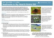
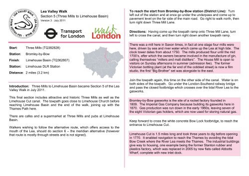
Lea Valley <strong>Walk</strong>Section 5 (Three Mills to Limehouse Basin)Version 3 : July 2011To reach the start from Bromley-by-Bow station (District Line): Turnleft out of the station and at once go under the underpass and come up topavement level on the far side of the main road. Go right to walk north, thenturn right down Three Mill Lane.<strong>Directions</strong>: Having come up the towpath ramp onto Three Mill Lane, turnleft to cross the canal, and then turn right down another towpath ramp.Start:Station:Finish:Station:Three Mills (TQ382828)Bromley-by-BowLimehouse Basin (TQ362807)Limehouse DLR StationDistance: 2 miles (3.2 km)Introduction: Three Mills to Limehouse Basin became Section 5 of the LeaValley <strong>Walk</strong> in July 2011.This final section includes attractive and historic Three Mills as well as theLimehouse Cut canal. The towpath goes close to Limehouse Church beforereaching Limehouse Basin and the end of the walk, joining up with theThames Path here.There are cafes and a supermarket at Three Mills and pubs at LimehouseBasin.<strong>Walk</strong>ers wishing to follow the alternative route, which offers access to themouth of the Lea, should do section 6 – the meridian alternative (howeverthat route is mostly through streets and is not signed).There was a mill here in Saxon times, in fact at one stage four mills werehere, driven by sea and river water which came up the Lea at high tide. Theclock tower dates from about 1750. The mills produced flour until the mid1700’s, after which the owners became involved in the manufacture of gin,calling themselves “millers and malt distillers”. The House Mill is open tovisitors on Sunday afternoons in summer (admission fee). The formerVictorian bottling plant (at the far end of the cobbled street) is now a filmstudio, the first “Big Brother” set was alongside to the east.Join the towpath again, this time on the other side of the canal. Water is onboth sides of the towpath. Go under the <strong>London</strong>-Southend railway bridgeand pass the closed footbridge which crosses over the tidal River Lea to thegasworks.Bromley-by-Bow gasworks is the site of a rocket factory founded in1809. The Imperial Gas Company because building its gasworks here in1870. Gas production was run down in the early 1960s, leaving seven ofthe eight Victorian gas holders, which are now used for storing natural gas.Keep forward to cross the white concrete Bow Lock footbridge, to reach theentrance to Limehouse Cut.Limehouse Cut is 1.5 miles long and took three years to dig before openingin 1770. It enabled navigation to reach the Thames by avoiding the tidalBow Creek where the River Lea meets the Thames. The industrial buildingsgive way to housing, one example being the former Stanton rubber andplastics factory, which was replaced in 2005 by new flats called AbbottsWharf, complete with new inlet dock.
Pass the lock houses, and just before the gates, bear right on to the floatingtowpath. Go under the Blackwall Tunnel Approach. The canal runs in astraight line in a southwest direction. It passes under the DLR and two roadbridges to go round the tiny Abbotts Wharf dock.After that, the path runs under Burdett Road. The waterway narrows atBritannia Bridge, which carries Commercial Road (A13) along the north sideof the Limehouse area. Soon after the bridge, there are gates on theleft. These give access to St Anne’s passage – an optional diversion to visitSt Anne’s Church. To reach the church, take the passage and then NewellStreet.A famous photograph was taken here in 1981 of the SDP “gang of four”launching the Limehouse Manifesto. A little further down river with theThames is the Grapes pub, some 400 years old, which was the inspirationfor the pub called “Six Jolly Fellowship Porters” in Dickens’ “Our MutualFriend”.To reach Limehouse Station (DLR): from the end of the walk turn rightacross the swing bridge at Narrow Street and go right into HorseferryRoad. At the end go ahead up the slope to the Basin and turn left at HurfordSalvi Carr. At Branch Street go right to Commercial Road. Then turn left forthe station.The Limehouse area is named after the lime kilns that were near theThames. Commercial Road was built in 1803 to link the West India Docksand the East India Docks with the City of <strong>London</strong>. This new toll road, aswas, reduced the size of St Anne’s Churchyard.Soon after Britannia Bridge, the Limehouse Cut bends to the right, to passunder a footbridge and enter Limehouse Basin itself.Limehouse Basin opened in 1812, only to be enlarged eight years later. Itwas reduced however in 1985. First it was known as Regent’s Canal Dockas it was also the entrance to Regent’s Canal (which links in turn to theGrand Union Canal). At that time the Limehouse Cut joined the Thames in adifferent place. The dock was much used by barges carrying coal inlandfrom ships coming up the Thames from Newcastle. It was only in 1864 thatthe Limehouse Cut was linked to Limehouse Basin.Keep the basin on the right-hand side. Here the towpath runs along the eastside of the Basin to pass the final lock and reach gates at NarrowStreet. Cross Narrow Street to see the Basin entrance.Limehouse Basin entrance is crossed at the swing bridge by NarrowStreet. The pub here is the former Regent’s Canal dockmaster’s house,built in 1910. Take the Thames Path down river a little way to look for theoriginal Limehouse Cut junction with the Thames, which was closed in1968.Lea Valley <strong>Walk</strong>Section 5 (Three Mills to Limehouse Basin )page 2www.walklondon.org.uk