Residential Land Availability Survey - South Gloucestershire Council
Residential Land Availability Survey - South Gloucestershire Council
Residential Land Availability Survey - South Gloucestershire Council
- No tags were found...

Create successful ePaper yourself
Turn your PDF publications into a flip-book with our unique Google optimized e-Paper software.
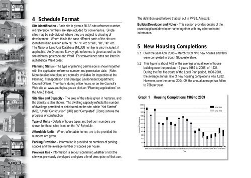
4 Schedule FormatSite identification - Each site is given a RLAS site reference number,old reference numbers are also included for convenience. Singlesites may be sub-divided, where they are subject to phasing ofdevelopment. Where this is the case different parts of the site areidentified using a letter suffix “a”, “b”, “c” etc or “aa”, “ab”, “ac” etc.The National <strong>Land</strong> Use Database (NLUD) number is also included, ifapplicable. An Ordnance <strong>Survey</strong> grid reference is given as well as thesite address, postcode and Ward. For convenience sites are listed inalphabetical Ward order.Planning Status - The type of planning permission is shown togetherwith the application reference number and permission date. (Note:More detailed site plans are normally available for inspection at thePlanning, Transportation and Strategic Environment Department,<strong>Council</strong> Offices, Thornbury, during office hours, or on the <strong>Council</strong>’sWeb site at: www.southglos.gov.uk click-on “Planning applications” onthe A to Z Index).Site Size and Capacity - The area of the site is given in hectares, andthe density is also shown. The dwelling capacity reflects the numberof dwellings permitted or anticipated on the site, while “Not Started”(NS), “Under Construction” (UC) and “Completed” (Comp) shows theprogress of construction.Type of Units - Details of house types and bedroom numbers areshown for those sites listed on the “A” Schedule.Affordable Units - Where affordable homes are to be provided thenumbers are given.Parking Provision - Information is provided on numbers of parkingspaces and the average number of spaces per house.Previous Use - Information is set out confirming whether or not thesite was previously developed and gives a brief description of that use.The definition used follows that set out in PPS3, Annex B.Builder/Developer and Notes - This section provides details of theowner/applicant/developer name together with any other relevantinformation.5 New Housing Completions5.1 Over the year April 2008 – March 2009, 916 new houses and flatswere completed in <strong>South</strong> <strong>Gloucestershire</strong>.5.2 This figure is about 74% of the average annual level of housebuilding over the previous 19 years 1989 to 2008, of 1,231.During the first five years of the Local Plan period, 1996-2001,the average annual rate of new housing completions was 1,282.However, over the period 2004-09, the annual average has fallento 758 per year.Graph 1 Housing Completions 1989 to 2009Number of Completeions2200200018001600140012001000800600400200089/90 90/91 91/92 92/93 93/94 94/95 95/96 96/97 97/98 98/99 99/00 00/01 01/02 02/03 03/04 04/05 05/06 06/07 07/08 08/09YearSmall SitesLarge Sitespage 4