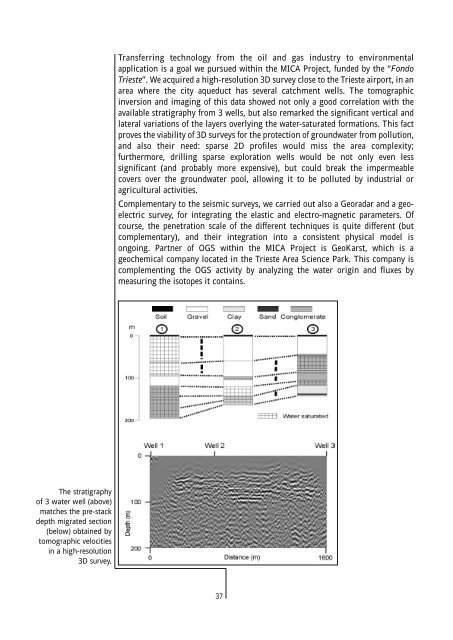
Transferring technology from the oil and gas industry to environmentalapplication is a goal we pursued within the MICA Project, funded by the “FondoTrieste”. We acquired a high-resolution 3D survey close to the Trieste airport, in anarea where the city aqueduct has several catchment wells. The tomographicinversion and imaging of this <strong>data</strong> showed not only a good correlation with theavailable stratigraphy from 3 wells, but also remarked the significant vertical andlateral variations of the layers overlying the water-saturated formations. This factproves the viability of 3D surveys for the protection of groundwater from pollution,and also their need: sparse 2D profiles would miss the area complexity;furthermore, drilling sparse exploration wells would be not only even lesssignificant (and probably more expensive), but could break the impermeablecovers over the groundwater pool, allowing it to be polluted by industrial oragricultural activities.Complementary to the seismic surveys, we carried out also a Georadar and a geoelectricsurvey, for integrating the elastic and electro-magnetic parameters. Ofcourse, the penetration scale of the different techniques is quite different (butcomplementary), and their integration into a consistent physical model isongoing. Partner of <strong>OGS</strong> within the MICA Project is GeoKarst, which is ageochemical company located in the Trieste Area Science Park. This company iscomplementing the <strong>OGS</strong> activity by analyzing the water origin and fluxes bymeasuring the isotopes it contains.The stratigraphyof 3 water well (above)matches the pre-stackdepth migrated section(below) obtained bytomographic velocitiesin a high-resolution3D survey.37
Geophisical interpretationCoordinator: Angelo CAMERLENGHIThe activity of the group in 2000 was characterised by intensive <strong>data</strong> <strong>acquisition</strong> atsea and on land. At the same time <strong>data</strong> processing and interpretation have beencarried out in the <strong>OGS</strong> headquarters. Data <strong>acquisition</strong>, focussed to theunderstanding of the geology of continental margins, was mainly in Antarctica,within the projects WEGA (Wilkes Land Glacial History), LARSEN (DeglacialHistory of the Larsen Ice Shelf - Weddell Sea), ODP Leg 188 in Prydz Bay(M. Rebesco was shipboard sedimentologist), and TESAC (Tectonic and CenozoicEvolution of the South America-Scotia Plate Boundaries) sponsored by PNRA. Inaddition, we participated in a cruise of the EU project STRATAGEM(Stratigraphical Development of the Glaciated European Margin) on the Faroe-Shetland margin. The <strong>data</strong> we collected span from single and multi channelseismic reflection, chirp sonar, core logging <strong>data</strong>, gravity at sea, to structuralgeology <strong>data</strong> and lake bathymetry on land. Of particular relevance for the groupwas the continuing activity with the recently acquired Geotek multi-sensor corelogger, and the utilisation of the Datasonic chirp sonar in Antarctica.Processing and interpretation were on seismic, gravity, magnetic <strong>data</strong>, coresamples, core logging, downhole logging, and oceanographic <strong>data</strong> collected in theprevious years within the research programs sponsored by PNRA on the PacificMargin of the Antarctic Peninsula (Projects ODP Leg 178, SEDANO, SedimentDrifts of the Antarctic Offshore, and BSR, Bottom Simulating Reflectors), in theSouth Scotia Sea (Crustal Structure and Evolution of the Powel Basin), and in theRoss Sea (Cape Roberts Drilling Project and Evolution of the West Antarctic IceSheet). Research was conducted with the highest possible level of internationalcooperation and by supporting research fellowships at other research institutionssuch as INGV, Rome, and the University of Trieste.The research activity involving the processing of Synthetic Aperture Radar (SAR)satellite images has continued with applications to areas such as Antarctica, Tierradel Fuego and the surroundings of city of Trieste. In parallel, we started a newproject as a joint venture with SOPROMAR in a contract with the ItalianGeological Survey to produce test sheets of the marine gravity maps of the coastalzones of Italy.In the field of environmental geology and geophysics, we participated in research,within broader <strong>OGS</strong> projects, on the aquifers identification and mapping in theFriuli Venezia Giulia region. Another project has involved the identification ofkarstic cavities with micro-gravimetric techniques.Research applied to petroleum exploration included one project funded by AGIP onthe kinematics of salt deformation in the Eastern Mediterranean and distal Nilecone (in cooperation with the University of Parma and IGM, Bologna), and theparticipation in the Ormen Lange Verification project sponsored by NorskHydrothrough SINTEFF on the theme of gas hydrates.38
- Page 2 and 3: Istituto Nazionaledi Oceanografia e
- Page 4: ContentsIntroduction . . . . . . .
- Page 7 and 8: Sea, close to the Antarctic Peninsu
- Page 10 and 11: Measurements while drilling (data a
- Page 12 and 13: Vallazza research well: 3D-RVSP sei
- Page 14 and 15: Therefore, having beside a high ele
- Page 16 and 17: • Standard 20’ container modifi
- Page 18 and 19: • Offshore gravimetric survey “
- Page 20 and 21: The GPR instruments.Integrated meth
- Page 22 and 23: Seismic data processingCoordinator:
- Page 24 and 25: allow for the different spatial sam
- Page 26 and 27: Results of applicationof the static
- Page 28 and 29: Measurements while drilling (R & D)
- Page 30 and 31: Wave modelingCoordinator: Géza SER
- Page 32 and 33: Phase velocitiesof the five wavemod
- Page 34 and 35: (SPEM) and the Wavenumber Integrati
- Page 36 and 37: The Marche Microzonation Project is
- Page 38 and 39: Seismic inversionCoordinator: Aldo
- Page 40 and 41: The joint inversion ofdirect, refle
- Page 44 and 45: At the end of the year, we started
- Page 46 and 47: ODP Leg 178 - Site LocationSite 109
- Page 48 and 49: Core 1165B-14HComposite diagram sho
- Page 50 and 51: Cenozoic Evolution of the South Ork
- Page 52: Magallanes-Fagnanomaster faultTWT (
- Page 55 and 56: three wells in the Blake Ridge, off
- Page 57 and 58: Backstripping modelling in the fram
- Page 59 and 60: The purpose is to merge the land an
- Page 61 and 62: AdministrationCoordinator: Dario Co
- Page 63 and 64: CARCIONE, J. M., AND HERMAN, G., AN
- Page 65 and 66: FERRACIOLI, F., COREN, F., BOZZO, E
- Page 67 and 68: Presentations at meetings and conve
- Page 69 and 70: ROSSI, G., BÖHM, G., MADRUSSANI, G
- Page 71 and 72: Book reviewsVESNAVER, A., 2000, Rev
- Page 73 and 74: Fred DAVEY (Institute of Geological
- Page 75 and 76: Trieste and scienceTrieste is also
- Page 77: 72TRIESTE