A GIS-based flow model for groundwater resources management in ...
A GIS-based flow model for groundwater resources management in ...
A GIS-based flow model for groundwater resources management in ...

You also want an ePaper? Increase the reach of your titles
YUMPU automatically turns print PDFs into web optimized ePapers that Google loves.
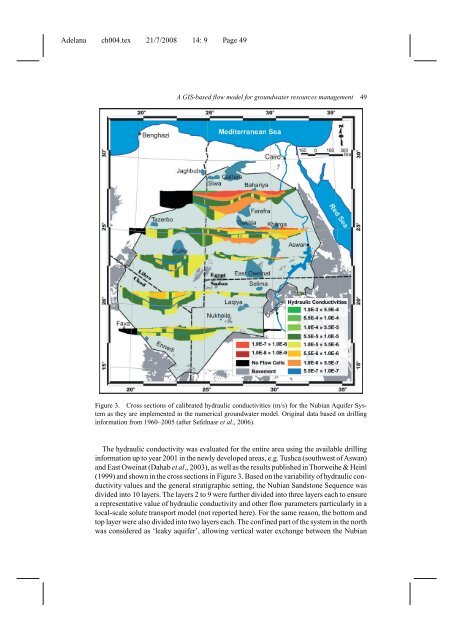
Adelana ch004.tex 21/7/2008 14: 9 Page 49A <strong>GIS</strong>-<strong>based</strong> <strong>flow</strong> <strong>model</strong> <strong>for</strong> <strong>groundwater</strong> <strong>resources</strong> <strong>management</strong> 49Figure 3. Cross sections of calibrated hydraulic conductivities (m/s) <strong>for</strong> the Nubian Aquifer Systemas they are implemented <strong>in</strong> the numerical <strong>groundwater</strong> <strong>model</strong>. Orig<strong>in</strong>al data <strong>based</strong> on drill<strong>in</strong>g<strong>in</strong><strong>for</strong>mation from 1960–2005 (after Sefelnasr et al., 2006).The hydraulic conductivity was evaluated <strong>for</strong> the entire area us<strong>in</strong>g the available drill<strong>in</strong>g<strong>in</strong><strong>for</strong>mation up to year 2001 <strong>in</strong> the newly developed areas, e.g. Tushca (southwest ofAswan)and East Owe<strong>in</strong>at (Dahab et al., 2003), as well as the results published <strong>in</strong>Thorweihe & He<strong>in</strong>l(1999) and shown <strong>in</strong> the cross sections <strong>in</strong> Figure 3. Based on the variability of hydraulic conductivityvalues and the general stratigraphic sett<strong>in</strong>g, the Nubian Sandstone Sequence wasdivided <strong>in</strong>to 10 layers. The layers 2 to 9 were further divided <strong>in</strong>to three layers each to ensurea representative value of hydraulic conductivity and other <strong>flow</strong> parameters particularly <strong>in</strong> alocal-scale solute transport <strong>model</strong> (not reported here). For the same reason, the bottom andtop layer were also divided <strong>in</strong>to two layers each. The conf<strong>in</strong>ed part of the system <strong>in</strong> the northwas considered as ‘leaky aquifer’, allow<strong>in</strong>g vertical water exchange between the Nubian