2006-07 - Kerala Forest Research Institute
2006-07 - Kerala Forest Research Institute
2006-07 - Kerala Forest Research Institute
- No tags were found...

You also want an ePaper? Increase the reach of your titles
YUMPU automatically turns print PDFs into web optimized ePapers that Google loves.
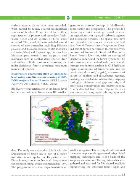
<strong>Kerala</strong> <strong>Forest</strong> <strong>Research</strong> <strong>Institute</strong>Annual report <strong>2006</strong>-<strong>07</strong>various aquatic plants have been recorded.With regard to fauna, several unidentifiedspecies of beetles, 37 species of butterflies,eight species of primary and secondary freshwaterfishes and 23 species of birds wererecorded. The faunal elements included severalspecies of rare butterflies including Phalantaphalanta and Castalius rosimon, exotic mollusks(Achatina fullica) and Vaginulus sp., birds such asMalabar grey hornbill and wagtails, andmammals such as sambar deer, spotted deerand wildcat. Of the various ecosystems, themoist deciduous forests contained maximumnumber of species.Biodiversity characterization at landscapelevel using satellite remote sensing (DBT-DOS project) Phase-II study. KFRI <strong>Research</strong>Report No. 284 (Menon, A.R.R., <strong>2006</strong>).Biodiversity characterization at landscape levelhas been carried out in <strong>Kerala</strong> using IRS satellite...................................................................................................................................................................................data. The study was undertaken jointly with theDepartment of Space and is part of a majorinitiative taken up by the Department ofBiotechnology under its Network Programmefor Bioprospecting, which commenced in 1997.The programme is a true implementation of‘gene to ecosystem’ concept in biodiversityconservation and prospecting. This project is apioneering effort to create geospatial databaseon vegetation cover types, disturbance regimesand biological richness. The spatial data havebeen linked to the species database and fielddata from different strata of vegetation. Detailedsampling was performed in comparativelyundisturbed forests of Goodrikal Reserve inRanni <strong>Forest</strong> Division, with an ecologicalinsight to understand the forest dynamics. Theinformation system evolved in the present studythrough multicriteria analysis in GIS facilitatesrapid assessment of biodiversity and itsmonitoring (loss and/or gain), assessment ofnature of habitats and disturbance regimes,evolving species-habitat relationship, mappingbiological richness and gap analysis, andprioritizing conservation and bioprospecting.A very detailed land cover map of the areawas prepared using aerial photographs andsatellite imageries. The density sliced version ofthe cover map was also generated using digitalmapping techniques and is the basis of thesampling site selection. The vegetation data weregathered and analyzed for 25 selected localitiesrepresenting the different forest types and15