Part 3 - Australian Alps National Parks
Part 3 - Australian Alps National Parks
Part 3 - Australian Alps National Parks

Create successful ePaper yourself
Turn your PDF publications into a flip-book with our unique Google optimized e-Paper software.
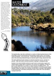
As the demand for fresh water increases, the potential for conflict over the source, yield and subsequentuse of water from mountain catchments grows. While there is no potential international conflict overwater resources in Australia, there is increasing conflict over the equitable sharing of water betweenenvironmental and commercial demands, and the sustainable use of water.In the past the grazing of domestic stock in the <strong>Australian</strong> alpine catchments resulted in extensivedisturbance and degradation of the native vegetation cover and over large areas, severe soil erosion.Grazing has now all but ceased in the alpine catchments, only occurring in several areas in the southernpart of the <strong>Alps</strong> in the State of Victoria.The grazing impacts have been replaced by the increasing development taking place within the mountaincatchments, to provide for tourism and recreational activities. This is placing a renewed pressure on thesoils, vegetation and water yields of the catchments. Management conflicts are increasing, hence carefulmanagement of mountain water resources must become a national (and global priority) in a world movingtowards a water crisis in the next century<strong>Alps</strong> catchments for water yieldThe world’s total freshwater reserves are in the order of 36 million Km 3 but the rivers and lakes ofAustralia, hold and carry only about 0.007 percent of this total fresh water ( 34.5 billion m 3 ), or less than9 percent of the annual flow of the Amazon.The high mountain catchments of southeastern Australia cover a little over 25000sq km with 5200sq kmbeing within alpine and subalpine elevations. (snow-covered for 1 to 3 months). These catchments arevery efficient in capturing and delivering to rivers and streams, over several months, up to 1000mm of theannual total precipitation of 1800 to 2500mm. The catchments yield the greater part (approx 65% or 8000to 10000 gigalitres) of the inflow to the Murray, Murrumbidgee and Snowy River systems. Of this wateryield, 3780 GL of the Murray River flows are diverted to off-river uses and 2350 GL from theMurrumbidgee River. The bulk of the water is used for irrigation (approx 95%) with the remainder beingused for stock and domestic requirements and for industrial use.The Murray River catchmentsThe Murray River has its source about 45 Kms southeast of Mt Kosciuszko. The major NSW tributaryrivers are the Swampy Plains River and the Tooma River which also arise in the <strong>Alps</strong>. The majorVictorian mountain tributaries are the Mitta Mitta River and the Kiewa River. The Hume Dam on theMurray River and Dartmouth Dam on the Mitta Mitta River above Hume Dam store and regulate thedownstream delivery of flows for irrigation, urban use and environmental purposes.The mountain catchments above Hume Reservoir cover less than 1.5% of the total Murray-Darling Basinbut yield about 38% of the total annual inflow to the Murray. About one third of the water yield is fromthe Mitta Mitta catchments in the Victoria alpine area and two thirds from the upper Murray catchmentsin the New South Wales alpine area. The total annual flow in the Murray is very low by world standards,for example the average annual flow is less than 3.5% of that of the Mississippi River and less than 0.25%of the Amazon. Approximately 66% of Murray River flows are diverted annually, providing water forirrigation over approximately 700000 ha. along the river downstream of Hume Dam.Murrumbidgee River CatchmentsThe Murrumbidgee River rises in the Snowy Mountains north of Mt Kosciuszko where the headwatersare captured by Tantangara Dam and diverted to Eucumbene Dam from which is released forhydroelectric generation through the Murray and Tumut River systems.The largest dam downstream of Tantangara Dam is Burrinjuck Dam, which stores, and regulates releasesof approximately 1026GL annually to the Murrumbidgee and Coleambally Irrigation Areas and severalsmaller adjoining irrigation areas. The major tributaries to the river above Burrinjuck Dam are theNumeralla, Bredbo Goodradigbee, Cotter, Molonglo and Yass Rivers. Below Burrinjuck Dam the major220Celebrating Mountains – An International Year of Mountains ConferenceJindabyne, New South Wales, Australia