Part 3 - Australian Alps National Parks
Part 3 - Australian Alps National Parks
Part 3 - Australian Alps National Parks

You also want an ePaper? Increase the reach of your titles
YUMPU automatically turns print PDFs into web optimized ePapers that Google loves.
200Celebrating Mountains – An International Year of Mountains ConferenceJindabyne, New South Wales, Australia
Landscape - Level Conservation For A World Heritage Site In Nepal Pralad Yonzon Resources Himalaya AbstractDespite eight natural world heritage sites in the Himalayas (India 4, China 2, and Nepal 2), manycountries including Nepal request for more. Recently, Shey Phoksundo <strong>National</strong> Park (SPNP) in westNepal, has been proposed. This study suggests that Dolpo of SPNP and Mustang of the AnnapurnaConservation Area (ACA), are similar in geology, soil, climate, rainfall and vegetation. In addition,Mustang and Dolpo form a single block of tertiary sedimentary zone in Nepal. Comparatively, Mustang ismuch richer in flora and fauna than Dolpo. Twenty-eight endemic plants are localized in ACA against the14 species of SPNP. Of 18 endemic butterflies of Nepal, 8 species of butterflies come mainly fromMustang and one from Dolpo. Rare species like argali (Ovis ammon hodgsoni), brown bear (Ursusarctos), kiang (Equus kiang) and Tibetan gazelle (Procapra picticaudata) are found only in Mustang. Insummary, the checklist overwhelms in favor of Mustang for its high endemism, species richness anddiversity. Therefore, recognizing SPNP alone for its inscription is not comprehensive. Conversely, Dolpoand Mustang, collectively called Nepal’s Tibetan marginal land which also constitute the southernmargin of the Tibetan Plateau, can be proposed as one world heritage site, to benefit many mountaincommunities through landscape-level conservation.BackgroundDespite eight natural World Heritage Sites (WHS) in the Himalayas, which are also protected areas (India4, China 2, and Nepal 2), many countries press for more. WHC site inclusion still has a great mediaappeal and tourist attraction because of significant economic benefits through volume tourism. With thesebenefits, there is also a profound responsibility to protect and manage the site, which is held in trust forthe entire world community (Hogan, 2001).Nepal contains four WHS: two cultural and two natural. Of the two natural sites in Nepal, Sagarmatha<strong>National</strong> Park (area: 1,148 km 2 ) was declared a world heritage site in 1979 in recognition of thesignificance of the world’s highest peak Mt. Everest (Sagarmatha), its associated flora and fauna, and theunique Sherpa culture. The Royal Chitwan <strong>National</strong> Park (area: 932 km 2 ), enlisted in 1984 in the WHS,has outstanding universal value as it harbors endangered rhinos and tigers.In 1999, the Ministry of Forest and Soil Conservation of Nepal proposed Shey Phoksundo <strong>National</strong> Park(SPNP, area: 3,555 km 2 ) (Figure 1) to WHC for inscription. The report entitled ‘Nomination of SheyPhoksundo <strong>National</strong> Park for Inclusion on the World Heritage List’ produced six criteria for itsinscription: three natural and three cultural. Under the natural criteria, the Park is considered to havebiological uniqueness because of climatic differences, altitudinal variation, trans-Himalayan conditions,and different zoo-geographical regionsCelebrating Mountains – An International Year of Mountains ConferenceJindabyne, New South Wales, Australia201
Cultural ContextThe southern margin of the Tibetan Plateau, constitute Mustang of ACA and Dolpo of SPNP, collectivelycalled Nepal’s Tibetan marginal land. Key areas of SPNP are Crystal Mountain, Lake Phoksumdo, andShey Gompa, collectively referred as Dolpo (also, inner Dolpo). Mustang of ACA, is epitomized by LoManthang — one of the last remaining walled cities in Asia and a frontier for mountain tourism in theHimalayas (Gurung and DeCoursey, 2000). Established in the 15 th century, the walled city (35 ha) hassome 200 households and two 15 th century gompas: Thubchen and Jhyampa (Rai, 1989).Local history suggests that the Lo Kingdom entered into cultural and political relations with Bhutan andLadhak in the 16 th century. The Dholwa (residents) of Dolpo, show close similarities in their socialstructure to the Loba (residents) of Mustang as Dolpo was once under the dominion of Lo (Rai, 1989). Lohad intensive socio-political engagement with Tibet before it came under the sovereignty of Nepal at theend of the 18 th century. Mustang was one of the 15 vassal states (Rajya) of Nepal, where the chief (Raja)was required to pay an annual tribute (Sirto) to the government and appropriate the remaining landrevenue for himself (Regmi, 1978).Physical SimilaritiesMustang and Dolpo are characterized by similar geology, soil, climate, rainfall and vegetation. Forexample, the rain shadow of the Nepal-Himalaya is an area with under 400 mm of annual rainfall, whichlies north of Kanjiroba, Dhaulagiri and the Annapurna massifs. This is where both Mustang and Dolpoform one contiguous area (8,793 km 2 ) (fig. 3). It is important to note that the Crystal Mountain, LakePhoksumdo, and Shey Gompa of SPNP and most of Mustang including Lo Manthang and DamodarKunda, lie in the rain shadow. The middle portion between Dolpo and Mustang is Tscharka Bhot.Similarly, of six geological zones in Nepal (Siwalik, Lesser Himalayan Crystalline, Lesser HimalayanSediments, Central Crystalline, Major Tertiary Granites and Tertiary Sediments), Mustang and Dolpoform a single block of Tertiary Sedimentary zone (Land Resource Mapping Project. 1986) with an area of11,843 km 2 formed between the Cambrian to Cretaceous period containing limestone, shale and quartzite(Fig. 4).Figure 3. Rain shadow in SPNP – ACAregion (Resources Himalaya, 2001)Figure 4. Teritiary sedimentary zone in SPNP – ACA region. Celebrating Mountains – An International Year of Mountains ConferenceJindabyne, New South Wales, Australia203
Similarly, the Kali Gandaki River Valley, world’s deepest valley, is an integral part of Mustang, where allsix Himalayan pheasant species are found and not in Dolpo. Regarding mammals, rare species like argali(Ovis ammon hodgsoni), brown bear (Ursus arctos), kiang (Equus kiang) and Tibetan gazelle (Procaprapicticaudata) are not found in Dolpo. But, Mustang has it all (BCD Project, 1993; Koirala and Shrestha,1997; Shah, 2001). Also, a new mouse hare (Ochotona lama) was discovered here (Mitchell, R. andPunzo, F. 1975). In summary, the list overwhelms in favor of Mustang whose importance cannot bedenied for its high endemism, species richness and diversity.Development Through ConservationHistorically, the Tibetan marginal land is recognized as one of the key physiogrpahic regions of Nepal(Hagen, 1960; Bista, 1991) . However, only High Himalaya, High Mountain, Middle Mountain, Siwalikand Terai are recognized today and such impulsive planning have had isolated Nepal’s Tibetan marginalland and its people from many forms of mainstream development. Perhaps, recognizing Dolpo andMustang together with Tscharka Bhot (area: 3,211 km 2 ) as one contiguous WHS, may bring bothconservation and development together.ConclusionThe proposal to link Dolpo of SPNP with Mustang of ACA with Tscharka Bhot as the biological corridorto conserve a contiguous landscape of the trans-Himalaya region as WHS, is of utmost importance. Aconservation effort of such nature, is not only to maintain its biodiversity but also to usher a long-ternbenefit to mountain communities by safeguarding their cultural heritage and identity.ReferencesBista, D.B. 1991.Fatalism and Development. Orient Longman. Calcutta.BCD Project. 1993. ACAP/KMTNC. Kathmandu.Gurung, C. and DeCoursey, M.A. 2000. Too much too fast: Lessons from Nepal’s lost Kingdom ofMustang. In: Tourism and development in mountain regions. eds. Godde et al. CAB International.London.Hagen, T. 1960. Nepal. Kummerly and Frey. Berne.Hogan, R. 2001. Making the grade. The IUCN Bulletin. No.2:8 - 9.Koirala, A.R. and Shrestha, R. 1997. Floristic composition of summer habitat and dietary relationshipbetween Tibetan argali and domestic goat in the Damodar Kunda. Agric. Univ. Norway.Land Resource Mapping Project. 1986. Geology Report. Kenting Earth Sciences Limited, Canada.Mitchell, R.M. and Punzo, F. 1975. Ochotona Lama sp. N. (Lagomorpha: Ochotonidae): A new pika fromthe Tibetan Highlands of Nepal. Mammalia. Vol. 39. No. 3: 419-422.Rai, N. K. 1989. World of the Loba: A study of the people of Mustang. Tribhuvan University,Kathmandu.Regmi, M. C. 1978. Land tenure and taxation in Nepal. Ratna Pustak Bhandar. Kathmandu.Shah, K. B. 2001. Press Release. KMTNC. Kathmandu.Shrestha, T. B. and Joshi, R. M. 1996. Rare, endemic and endangered plants of Nepal. WWF Nepal.Smith, C. 1994. Butterflies of Nepal. Tecpress Service, Bangkok.Yonzon, P.B. 1990. The 1990 wildlife survey in Shey-phoksumdo <strong>National</strong> Park, Dolpo, west Nepal.NCRTC/KMTNC. Kathmandu.Yonzon, P.B. 2001. The inseparable Tibetan landscape of Nepal. Habitat Himalaya,Vol. 8 (2).Celebrating Mountains – An International Year of Mountains ConferenceJindabyne, New South Wales, Australia205
206Celebrating Mountains – An International Year of Mountains ConferenceJindabyne, New South Wales, Australia
Addressing Invasive Plant Species As A Threat To The Natural Values Of The <strong>Australian</strong> <strong>Alps</strong>: English Broom As A Case StudyKate McArthurKeith Turnbull Research Institute. Department of Natural Resources and Environment. Frankston VIC 3199 SummaryEnglish broom, Cytisus scoparius, is an upright woody legumeous shrub native to western and centralEurope. Outside of its native range, English/Scotch broom (broom) is an aggressive invader of a broadrange of ecological habitats and mountainous vegetation communities. Since its introduction into the highcountry in the early 1800s, broom has naturalised over 150, 000 hectares from those first few planting’s,and has had a significant impact on invaded habitats through the formation of a chokingly denseunderstorey monoculture. Broom has reached management priority within the <strong>Australian</strong> <strong>Alps</strong> nationalparks (AAnps) due to its threat to and impact on biological diversity and its virtually unlimited potentialto spread throughout the whole biogeographical region. This paper will outline the development of astrategic response to broom within the <strong>Australian</strong> <strong>Alps</strong> and will use Victoria as a case study to illustratehow effective that response has been in affecting change.IntroductionEnglish broomBroom was introduced into Australia around 1800, after Governor King requested broom seeds fromEngland, which were to be grown and used as a substitute for hops (Hoskings et al 1996). Since itsintroduction, broom has become an aggressive invader of a wide range of ecological habitats. Broom’ssuccess as an aggressive invader rests with its ability to survive on low levels of resource availability. Awide tolerance of soil conditions, temperature and rainfall regimes, the ability to fix nitrogen in the soil,two flowering periods and the ability to set seed over a wide altitudinal range have contributed to itsspread (Williams 1981). The absence of predators has also contributed to the spread of broom in southeastern Australia.Broom is a prolific seeder with 2 flowering periods (spring and autumn). It is estimated that each matureplant produces on average 26, 000 viable seeds per year, the majority of which are stores in a soil seedbank characteristic of broom infestations. There can be up to 50, 000 seeds per square meter in the soil(CRC Weeds 2000). The latest viability figures for broom seeds stored dry stands at 80 years.Celebrating Mountains – An International Year of Mountains ConferenceJindabyne, New South Wales, Australia207
Broom In The <strong>Australian</strong> <strong>Alps</strong> Introduction of English broom to the <strong>Australian</strong> <strong>Alps</strong>Over 180 years ago an innocuous looking plant, English broom, was introduced into the <strong>Australian</strong> <strong>Alps</strong>.The early graziers, miners and timber getters who opened up the <strong>Alps</strong> nurtured in their settlementsvarious plants that held either sentimental, aesthetic or more practical value. English broom, valued for itssentimental links to the ‘old country’ and prized for its showy yellow flowers, was among these plants.Evidence also exists that English broom, with other species like willows and poplars, were used as slopestabilisation and erosion mitigation techniques throughout the goldfields of the high country (Fallavollitaand Norris 1992).In more recent times the introduction of broom seeds into the AAnps has been attributed to park users,including, bushwalkers, horse riders and 4WD enthusiasts and the use of broom infested fill material. Themovement of cattle has also been suggested as contributing to the introduction of broom into the<strong>Australian</strong> <strong>Alps</strong>.Distribution of broom within the <strong>Australian</strong> <strong>Alps</strong>The current distribution of broom within the <strong>Australian</strong> <strong>Alps</strong> reflects its symbiotic relationship with thevectors of introduction and spread. Consequently broom infestations are found at old townships; campsites, along tracks, trails and watercoursesBroom occurs throughout the Alpine <strong>National</strong> Park in Victoria, Kosciuszko <strong>National</strong> Park in NSW andNamadgi <strong>National</strong> Park in the ACT. The distribution of broom is reflected in the following table:AREA INFESTATION CHARACTERISTICS TOTAL AREA INFESTEDAlpine NPVictoriaDense and Widespread.Over 150 000 hectaresSource: Hoskings et al (1996)Kosciuszko NPNew South WalesGenerally characterised by scattered, isolatedinfestations.Over 20 000 hectaresDense infestations still persist in pockets of Source: Parsons andNamadgi NPACTthe park (eg: Tumut River).Generally characterised by scattered, isolatedinfestations.Table 1: Details of significant broom infestations in the <strong>Australian</strong> <strong>Alps</strong>.Cutherbertson (1992).Approximately 1000 hectares.5000 hectares potentialinfestationImpact of broom in the <strong>Australian</strong> <strong>Alps</strong>Broom has a significant impact on invaded habitats, primarily through the formation of dense understoreymonocultures. Broom desciminates biological diversity, out-competing most native understorey speciesand restricting the regeneration of the forest trees endemic to the area. Several species of rare andendangered flora are under threat from broom.Broom impacts on recreational pursuits in the <strong>Alps</strong> by restricting access to watercourses, tracks and trails,significantly increases fire hazard, and provides harbour for feral animals. Broom also has the potential todegrade the water quality and hence catchment values of the <strong>Australian</strong> <strong>Alps</strong>, through the displacement ofindigenous flora.208Celebrating Mountains – An International Year of Mountains ConferenceJindabyne, New South Wales, Australia
The Strategic Response To BroomThe invasive potential of broom has long been known. English broom was considered naturalised by1887, and was declared a noxious weed in 1901.To date the strategic response to broom by public land management agencies can be characterised bythree broad eras, ‘going it alone’, ‘agency support’ and the era of cooperation.Going it aloneOver the many years of management of the high country prior to the establishment of park agencies andthe AALC weeds such as English broom were controlled in an ad hoc, reactive poorly planned manner(Grenier and Good pp351). There was a lack of coordination in the control of weeds, both betweenneighbouring land managers and within the whole biogeographical region.The control programs were most often based on the application of herbicides and the effectiveness ofthese programs reflected the application technologies available. Prior to 1970s, spray technology wasantiquated and it wasn’t until the adoption of diaphragm pumps in the late 1970s early 1980s that thewidespread control of weed species became practical (Sedgman pers. com.). The limited and toxic natureof chemicals available for use against woody weeds and the increasing awareness of their detrimentalimpacts, not only on the environment, but also the health of the operators, also hampered the effectivewidespread and comprehensive control of English broom prior to 1970s. Integrated weed management,while perhaps occurring on an informal ad hoc basis, certainly hadn’t reached the vernacular of the landmanagers of the day.Agency supportThe formal declaration of the high country as national parks in each respective state and territory broughtwith it a degree of strategy towards the control of exotic plant invaders such as broom. The New SouthWales <strong>National</strong> <strong>Parks</strong> and Wildlife Service has given a strong commitment to pest plant managementsince the declaration of the Kosciuszko <strong>National</strong> Park in its current form in 1967, of which broom hasbeen identified as one of the highest priority weeds to control. Both the ACT and Victorian governmentsdeveloped management plans for their parks in the late eighties, early nineties that gave representation tothe need to manage invasive weed species. However each park agency still operated ostensiblyindependently despite facing the same challenges across the same biogeographical region.<strong>Australian</strong> alps liaison committeeThe signing of the MOU and the birth of the <strong>Australian</strong> <strong>Alps</strong> Liaison Committee (AALC) in 1986 saw thestart of a coordinated strategic approach to the management of English broom in the <strong>Australian</strong> <strong>Alps</strong>. TheBroom workshop held in the same year at Barrington Tops in northern NSW highlighted the need for bothstrategic planning and integrated management when addressing broom.Fallavollita and NorrisIn 1992, the AALC commissioned the first comprehensive study into the occurrence of broom in the<strong>Australian</strong> <strong>Alps</strong> national parks. The report by Fallavollita and Norris represented a significant turningpoint in the strategic management of broom. For the 9 years before it was reviewed, the report gavedirection and a best practice guide to park ranges in the <strong>Australian</strong> <strong>Alps</strong> national parks. The report alsoconsolidated the significant achievements of broom control in Kosciuszko and Namadgi <strong>National</strong> <strong>Parks</strong>and gave hope to those areas of the Alpine <strong>National</strong> Park in which broom appeared to be winning.Celebrating Mountains – An International Year of Mountains ConferenceJindabyne, New South Wales, Australia209
Tumut workshop The English broom workshop held at Tumut in 1997 represents another turning point in the strategicmanagement of English broom in the <strong>Australian</strong> <strong>Alps</strong>. The workshop gave land managers an opportunityto take stock of their progress in controlling broom. Two significant outcomes resulted from the Tumutworkshop which we to define the new strategic direction of broom control. The first was the perceivedneed to update the 1992 Fallavollita and Norris report and the second was to identify the need toimplement the widespread biological control of English broom in the <strong>Alps</strong>.Biological controlBiological control involves using one living species (natural enemy) to control or suppress an unwantedspecies (target). Classical biological control, or the introduction of broom’s natural enemy from Europe,was identified as an important integrated control techniques to limit the growth and spread of broom inthe <strong>Alps</strong>. CSIRO had completed comprehensive testing into the host specificity of these agents, securedpermission to release a suite of (to date) four agents and had conducted field trials in both Kosciuszko andNamadgi <strong>National</strong> <strong>Parks</strong>. Trials in the Alpine <strong>National</strong> Park were conducted by the Victorian KeithTurnbull Research Institute.Post Tumut, commitment was given by the AALC, and a strong partnership of stakeholders in Victoria tofacilitate the widespread establishment of biological control agents as part of IWM at suitable broominfestations throughout the <strong>Alps</strong>. The English broom biocontrol program forms a cornerstone of thestrategic response to broom within Victoria today.Broom Management Strategy for the <strong>Australian</strong> <strong>Alps</strong> <strong>National</strong> <strong>Parks</strong>In 1998/1999 the AALC commissioned a review of the occurrence of English broom in the <strong>Australian</strong><strong>Alps</strong> and the development of an integrated broom management strategy for use by field staff. The goal ofthe strategy was to assist land managers minimise the impact of broom within the AAnps. The strategybuilt on the earlier Fallavolita and Norris report and incorporated information and ideas on the bestpractice management of broom, gleaned from outstanding work such as the 1997 Barrington Tops broomcontrol strategy and current research findings. It was written through close consultation with past andpresent land managers and reflected the many lessons learnt the hard way in the Kosciuszko broommoprogram over the past 30 years. The strategy represented a ‘new breed’ of management plan thatendeavoured to set out the actions and resources required to implement the ‘best practice’ management ofbroom.Protecting the natural treasures of the <strong>Alps</strong>In 2000, the AALC, through the Natural Heritage Working Group, established a project to document thesignificant natural features of the <strong>Australian</strong> <strong>Alps</strong> and identify and rank the threats to them. Peter Coyne’sproject “Protecting the natural treasures of the <strong>Australian</strong> <strong>Alps</strong>” identified the significant natural features,identified threatening processes, current and potential, and ranked the magnitude of threat. Out of a list ofalmost 100 threats encompassing pest plants and animals, land degradation and habitat destructionthrough to climate change, English broom was identified as the number one most significant threat to thenatural treasures of the <strong>Australian</strong> <strong>Alps</strong>.Has Strategic Planning Made A Difference?Case study – broom control in the Alpine <strong>National</strong> Park, Victoria.The Eastern Unit of the <strong>Alps</strong> has arguably the worst infestation of broom in SE Australia, certainly in the<strong>Alps</strong>. The broom infestation, originating in the abandoned gardens and goldfields of the Glen Wills area,has spread 130 km downstream (Fallavollita and Norris 1992). It is characterised by dense, thick maturestands and approximately 45 Kilometres of this infestation borders the Alpine <strong>National</strong> Park (ANP).While the control of broom has been addressed in the area with varying degrees of commitment and210Celebrating Mountains – An International Year of Mountains ConferenceJindabyne, New South Wales, Australia
capacity for decades, in the broom season of 2000, <strong>Parks</strong> Victoria used the Broom Management Strategyfor the <strong>Australian</strong> <strong>Alps</strong> national parks (McArthur, 2000) to guide their control programs.The availability of the strategic plan has enabled <strong>Parks</strong> Victoria’s Alpine District to secure more fundsand to better direct available resources. Investment in the broom control program has increased 5 fold inthe last 3 years since the strategy was developed, and a dedicated English broom project officer for theEastern Unit of the <strong>Alps</strong> has been appointed.The strategy has facilitated a more pro-active and forward thinking approach to broom control within theANP. It has facilitated a large icon project, Protecting the Pathways to the <strong>Alps</strong>, concerned solely with theintegrated control of broom within the ANP. The program has largely removed the control of broom fromthe pressures of the normal pest plant programs. Protecting the Pathways to the <strong>Alps</strong> strongly supports theuse of biological control in strategic areas and reaffirms <strong>Parks</strong> Victoria’s commitment to long-termintegrated broom management.On the ground, the strategy has enabled a containment line to be maintained around the heart of theinfestation, and a prevention and eradication program to operate outside this area, where mainly scatteredand isolated broom plants occur.The last 3 years also seen great advances in the cooperative and cross-land tenure management of broomin areas adjacent to the ANP advocated by the broom management strategy. Industry bodies such asGoulburn-Murray Water and private landholders, united in the landcare movement, have joined forceswith <strong>Parks</strong> Victoria and the Department of Natural Resources and Environment to address English broomissues.DiscussionHistory shows that the strategic and repeated control of broom is effective in securing the progressiveeradication of broom, while the ad hoc nature of reactive management will have dire consequences. Thesuccess of the broom control program conducted in Kosciuszko <strong>National</strong> Park over the past 20 yearsindicates that the containment and eradication of broom is a manageable and achievable goal if resourceallocation is well directed and committed for long term management. Strategic planning helps to facilitatethis.At the very least, the success of our strategic response to broom lies in affecting change, empoweringnatural resource managers and increasing the understanding and awareness of both the visitors to andcommunities of Australia’s magnificent mountain landscapes.ReferencesCRC Weeds. (2000). Best Practice Management Guide for Environmental Weeds – Broom, Cytisusscoparius. Cooperative Research Centre for Weed Management Systems. Adelaide.Grenier, P., and Good. R.B. (1992). Les Alpes australiennes/The <strong>Australian</strong> <strong>Alps</strong>. Revue de GeographieAlpine. N°2-3 Tomme LXXX. Institut de Geographie Alpine France.Hosking, J.R., Smith, J.M.B. and Sheppard, A.W. (1996). The biology of <strong>Australian</strong> weeds 28. Cytisusscoparius (L.) Link subsp. scoparius. Plant Protection Quarterly, Vol. 11(3): 102-108.McArthur, K. (2000). English Broom (Cytisus scoparius) Management Stratgey for the <strong>Australian</strong> <strong>Alps</strong>national parks. <strong>Australian</strong> <strong>Alps</strong> Liaison Committee.Williams, P.A.. (1981). Aspects of the ecology of broom (Cytisus scoparius) in Canterbury, NewZealand. New Zealand Journal of Botany, Vol. 19: 31-43.Celebrating Mountains – An International Year of Mountains ConferenceJindabyne, New South Wales, Australia211
212Celebrating Mountains – An International Year of Mountains ConferenceJindabyne, New South Wales, Australia
Ecology Of Disturbance: The Effect Of Tourism Infrastructure On Weeds In The <strong>Australian</strong> <strong>Alps</strong> Catherine Pickering 1 , Wendy Hill 1 and Frances Johnston 21 School of Environmental and Applied Sciences, Griffith University, Gold Coast Campus, PMB 50 Gold Coast Mail Centre QLD 9726, Australia. 2 PO Box 192, 40 McIntosh Circuit, Murrumbateman NSW 2586, Australia. AbstractTourism is a major form of land use in the <strong>Australian</strong> <strong>Alps</strong> national parks. A range of tourisminfrastructure has been provided within the region by state and territory governments (through protectedareamanagers and traffic authorities), local governments, and tourism operators. The construction,maintenance and use of roads, tracks, picnic areas, buildings and other artificial structures often causedisturbance to natural vegetation. Such disturbances can favour the establishment and spread of weedspecies. The majority of the 175 alien plant taxa in the <strong>Australian</strong> <strong>Alps</strong> are found in disturbed areas:along roadsides/walking tracks (78% of taxa) and around resorts (58%). Around 20% of these taxa arenaturalised; that is, able to reproduce and grow in the absence of further human activities.The potential of different types of infrastructure to favour weeds over natives needs to be taken intoconsideration. This applies to the provision of walking tracks, which are long, linear disturbancesthrough natural vegetation.When upgrading or providing new tracks, the choice of track surface type may largely be influenced byinitial construction cost. However, the ongoing cost of managing impacts (e.g. weeds) associated withvarious types of surface needs to be considered during the decision-making processes. Recent research bytwo of these authors has compared weed cover and loss of natural vegetation associated with fourdifferent walking track types: gravel tracks, concrete pavers, unformed tracks and raised steel metalwalkways. Variation in the area of disturbance (weed cover and bare areas) associated with each tracktype was found. Gravel tracks were associated with the greatest area of disturbance (the Summit Roadhad 4292 sq. m of disturbance per km of track, and narrower gravel tracks had 2942 sq. m per km). Forpavers there were 2682 sq. m of disturbance per km. Unformed tracks created much less disturbed areaper km of track (266 sq. m per km), though the extensive network of unformed tracks in the alpine area(~106 km) meant that potentially 28,400 sq. m are disturbed. The raised steel metal walkway had thelowest impact on the vegetation, with only 62 sq. m of disturbance per km (47-fold less than the narrowgravel track), despite having the heaviest use of any of the track types. It is clear from this that thedisturbance associated with some track types results in green weed verges and bare areas. These requirecostly ongoing management (e.g. spraying or rehabilitation). A more effective option would involveselecting tourism infrastructure that causes minimal disturbance during construction and use.These results illustrate that more consideration needs to be given to ensuring environmentalsustainability in the provision of tourism infrastructure in the <strong>Australian</strong> <strong>Alps</strong> national parks.Celebrating Mountains – An International Year of Mountains ConferenceJindabyne, New South Wales, Australia213
Natural area tourismTourism is the most rapidly growing industry in the world (Worboys et al. 2001; Newsome et al. 2002). Itaccounts for 12% of global gross national product, or around US$4.8 trillion dollars (Newsome et al.2002). One of the fastest growing sectors of the tourism industry in Australia and overseas is tourism tonatural areas, including national parks (Newsome et al. 2002). This incorporates nature-based tourism,where viewing nature is the primary objective; adventure tourism; wildlife viewing; ecotourism; andcultural tourism, where the cultural landscape or built environment occurs within a national park. InAustralia, the primary objective of park agencies is to conserve the natural and cultural values ofprotected areas (Worboys 1997; Worboys et al. 2001; Eagles et al. 2002; Newsome et al. 2002; Worboysand Pickering 2002). However, they must also provide tourism and recreational opportunities where theyfoster the visitor's appreciation and understanding of the natural and cultural value of protected areas(Worboys 1997).Tourism and recreation activities in national parks, along with the infrastructure provided, should beenvironmentally as well as socially and economically sustainable (Eagles et al. 2002; Newsome et al.2002; Worboys and Pickering 2002). However, there is often inadequate knowledge and understanding ofthe negative impacts that tourism infrastructure can have on the natural environment (Worboys et al.2001; Eagles et al. 2002; Newsome et al. 2002). Research into environmentally sustainable tourism hasshown that there is a range of negative direct and indirect impacts of tourism (Buckley et al. 2000;Newsome et al. 2002; Buckley et al. In press). Research in the <strong>Australian</strong> <strong>Alps</strong> by the CooperativeResearch Centre for Sustainable Tourism is examining impacts of a range of tourism activities andfacilities, such as snow manipulation, camping, trampling, horse riding, resorts, track types, and thegeneration of human waste. In particular, the resilience of native vegetation to disturbance is beingquantitatively assessed. In this paper, we report on the relationship between weeds and tourisminfrastructure in the <strong>Australian</strong> <strong>Alps</strong>, and describe recent findings of research into the impacts on nativevegetation of different track surface types.Tourism infrastructure and weeds in the <strong>Australian</strong> <strong>Alps</strong>Infrastructure associated with tourism in the <strong>Australian</strong> <strong>Alps</strong> provides habitat for a wide range of nonnativeplants. In a recent review of alien plants in the <strong>Australian</strong> <strong>Alps</strong> (Johnston and Pickering 2001a),175 non-native plant taxa were recorded in the <strong>Australian</strong> <strong>Alps</strong> above 1500 m. Of these, 78% were foundalong roadsides and/or paths, and 58% in the resort areas. Some species, such as the clovers (Trifoliumarvense, T. dubium, T. pratense, T. repens, T. ambiguum, T. glomeratum, and T. hybridum) and somegrasses (Agrostis capillaris, A. stolonifera, Dactylis glomerata, Festuca rubra, Lolium perenne, Phleumpratenses, Poa annua, P. pratense and Avena sp.) were deliberately introduced for use in rehabilitation(Johnston and Pickering 2001a). Others, such as broom (Cytisus scoparius), lupins (Lupinus incanus) andattractive daisies (Chrysanthemum parthenium, Anthemis punctata, Leucanthemum spp.) have beendeliberately planted in gardens in and around resorts and other buildings (McDougall and Appleby 2000;Johnston and Pickering 2001a; Pickering et al. In press). There are also large scale weed infestationsaround some parks facilities such as Waste Point in Kosciuszko <strong>National</strong> Park (Author obs.)..In the recent biodiversity survey, 35% of the total flora recorded were 146 non-indigenous taxa found inthe 27 sq. km area from Thredbo Village to the top of Mt Kosciuszko (Pickering et al. In press). The vastmajority were associated with tourism infrastructure. Within the garden areas of Thredbo Village 103 taxathat are not indigenous to the region were recorded, mostly deliberately planted. In the disturbed areasaround the resort, again non-indigenous taxa predominated, with 49 out of the 51 taxa recorded not nativeto the area. On the ski slopes there was also a relatively high diversity of non-indigenous taxa, with 29identified (30% of the species recorded on the slopes).The presence of so many non-indigenous taxa within a national park is of concern. Among these taxa arespecies that could potentially spread from garden beds into adjacent disturbed areas, and even into thenatural vegetation, becoming environmental weeds. A high diversity of non-indigenous flora has alsobeen found for the ski resorts in Victoria, creating similar issues for the management of the adjacentnational parks (McDougall and Appleby 2000).Why are weeds a problem?214Celebrating Mountains – An International Year of Mountains ConferenceJindabyne, New South Wales, Australia
Weeds are one of the most serious threats to Australia's natural environment (COA 1999). They can havea range of negative impacts, including displacement of native species and modification of ecosystemfunctioning. Specific impacts include acceleration of soil erosion, alteration of fire regimes, limitation ofthe recruitment of native species, alteration in geomorphological process, acceleration of extinction ratesof rare and threatened flora and fauna, alteration in the hydrology of a ecosystem, alteration in the nutrientcontent of soils, and effects on herbivory rates (Carr et al. 1992; Csurches and Edwards 1998; COA 1999;Low 1999).Intact native vegetation is thought to be relatively resistant to weed invasions (Csurches and Edwards1998; COA 1999). However, once vegetation is disturbed, weeds can become established (COA 1999).The disturbance may be natural, but if weed propagules are present then weeds can become established,altering natural cycles (Csurches and Edwards 1998). Alternatively, anthropomorphic disturbance, suchas clearing of vegetation for the provision of tourism infrastructure, can alter ecological processes andfavour weeds (Csurches and Edwards 1998; COA 1999; Johnston and Pickering 2001a). In some cases,weed propagates can be deliberately or accidentally introduced during the construction and use of theinfrastructure. Problem weeds tend to have high reproductive rates, vegetative growth and tolerance to awide range of growing conditions. These characteristics make them highly competitive in the bare groundcreated by disturbance (Csurches and Edwards 1998). Continued use of an area can promote weedsbecause of repeated disturbance that results in damage to vegetation, and in some cases, because ofincreased nutrification from human waste and other materials.Examples of impacts of environmental weeds in the <strong>Australian</strong> <strong>Alps</strong> are: alteration of stream ecology(willows); displacement of native species (broom and yarrow); alteration of behaviour of native wildlife,such as feeding (willows and blackberries); alteration of the visual appearance of natural areas (ox-eyeddaises, lupins, sorrel, dandelions and yarrow); and changes in soil chemistry (introduced clovers) (AALCundated; Sainty et al. 1998; Johnston and Pickering 2001a, 2001b).Walking tracks, native vegetation and weedsWhen providing infrastructure such as walking tracks it is important to take into account environmentimpacts, as well as direct financial costs and social issues (safety, visitor preferences etc.) (Worboys et al.2001). For example, there is variation in the impact of different track types on the native vegetation,particularly in relation to the presence of weeds and bare areas. Recent research in the Kosciuszko alpinearea compared the impacts of four track types on the native vegetation: (1) unformed trails (former bridlepaths or paths formed by tourists walking off hardened tracks); (2) gravel tracks, including both sectionsof the Summit Road and Charlotte Pass to Blue Lake track; (3) concrete pavers; and (4) raised steel meshwalkway. We compared species richness, bare area and cover of weeds between quadrats locatedunder/on the track, on the verge and in the adjacent native vegetation (Hill and Pickering Draftmanuscript).Seven species of weed were associated with paved and gravel tracks: sorrel (Acetosella vulgaris),dandelion (Taraxacum officinale), flatweed (Hypochoeris radicata), white clover (Trifolium repens),browntop bent (Agrostis capillaris), Muller’s bent (Agrostis muelleriana), and swamp bent (Agrostis sp.).These weeds formed extensive cover along the verge of the concrete pavers and gravel tracks (40% ofverge of pavers were weeds, and 20% of verge of gravel track). Only one weed, the naturalised speciessorrel, was found on the verge of the raised metal walkway, (just 0.29% of the verge). However, this isthe same as in the adjacent native vegetation. No weeds were associated with the unhardened track.The total area of disturbance associated with each track type also differed. This has importantimplications for management decisions about new tracks or the upgrading of existing tracks. For eachkilometre of unhardened track there was 266 sq. m of disturbed area, mostly bare ground on the footpaditself. If the unhardened track were to be replaced by pavers, then the area of disturbance (weed cover andbare ground, including the track) would actually increase ten fold, to 2682 sq. m free of native vegetationper km of gravel track. If gravel were to be used to replace unhardened tracks, then the area ofdisturbance would be even more, 11 fold greater than the informal track (2942 sq. m free of nativevegetation per km of gravel track). For the Summit Road, the area free of non-native vegetation is evengreater, at 4292 sq. m. If, however, an unhardened track were to be replaced with a raised steel meshwalkway, then the area of disturbance would decrease by 400%, to only 62 sq. m of non-native vegetationCelebrating Mountains – An International Year of Mountains ConferenceJindabyne, New South Wales, Australia215
(bare areas and weed cover) per km of this track type. Moreover, in the sample studied, this is similar tothe amount of bare areas and sorrel cover in the adjacent native vegetation and hence does not appear tobe a consequence of disturbance caused by the walking track.If the New South Wales <strong>National</strong> <strong>Parks</strong> and Wildlife Service was to control the extensive weed coverassociated with tracks in the alpine area by rehabilitating the verges of the tracks, the cost would be$50,827 per km of paved track, $41,246 per km of narrow gravel track, and $32,078 per km for theSummit Road (using an estimate of $119 per sq. m for rehabilitation, Johnston 1998). There is no need forrehabilitation to control weeds for the raised steel mesh walkway. Clearly, if the cost of weed control(estimated as cost of revegetation) during use of the tracks is incorporated into their total cost then, eventhough the cost of construction of the raised steel mesh walkway is initially greater than that of gravel(Harrigan 2001), the total cost of this option is cheaper than that of other track types. In addition, it has farfewer negative impacts on the environment. This cost effectiveness becomes even more apparent ifestimates of future removal of any of the tracks are taken into consideration. The cost of justrehabilitating the area of disturbance associated with the surface of the gravel or concrete pavers tracks issubstantial. For the Summit Road it would be around $510,600 per km, while for a narrower gravel trackit would be around $153,900 per km. For the raised steel mesh walkway little or no rehabilitation wouldbe required, because the vegetation cover under and adjacent to the track is equivalent to the nativevegetation.What to do?Currently, much of the control of weeds in the <strong>Australian</strong> <strong>Alps</strong> is by herbicide spraying, which isexpensive, has limited success for some weeds, and may harm native vegetation (AALC undated; Formanand Alexander 1998; Sainty et al. 1998; Sanecki 1999). More recently, biological control programs havebeen introduced for weeds such as broom, St Johns Wort, Paterson’s Curse and blackberry (AALCundated). Also, parks agencies are encouraging resorts to use indigenous plantings rather than exoticplants, both on ski slopes and in the gardens (Pickering et al., In press). Active rehabilitation of previouslydisturbed areas is also critical for weed control (AALC undated; Parr-Smith and Polley 1998). While thistilts the ecological balance in favour of native vegetation, it can be expensive. In addition to thesemeasures, we feel that careful selection of tourism infrastructure options is crucial. This should be basedon a greater appreciation of the environmental and financial cost that can be incurred, in terms ofdisturbance to native vegetation and the introduction and establishment of weeds, when one form ofinfrastructure is chosen over another. .AcknowledgementsMuch of this research has been supported by the Cooperative Research Centre for Sustainable Tourism.The support of the New South Wales <strong>National</strong> <strong>Parks</strong> and Wildlife Service for the research of FrancesJohnston is also gratefully acknowledged.216Celebrating Mountains – An International Year of Mountains ConferenceJindabyne, New South Wales, Australia
ReferencesAALC See <strong>Australian</strong> <strong>Alps</strong> Liaison Committee<strong>Australian</strong> <strong>Alps</strong> Liaison Committee (Undated). Weed Management Manual for the <strong>Australian</strong> <strong>Alps</strong><strong>National</strong> <strong>Parks</strong>. AALC, Canberra.Buckley, R. C., Pickering, C. M. and Warnken, J. (2000). Environmental management for alpine tourismand resorts in Australia. In: Goode, P. M., Price, M. F. and Zimmermann, F. M. (eds) Tourism andDevelopment in Mountain Regions. CABI Publishing. New York, pp. 27-46.Buckley, R. C., Weaver, D. and Pickering, C.M. (In press). Nature Tourism and the Environment. CABIPublishing, New York.Carr, G.W. Yugovic, J.V. and Robinson, K.E. (1992). Environmental Weed Invasions in Victoria:Conservation and Management Implications. Department of Conservation and Environment,Melbourne.COA See Commonwealth of Australia.Commonwealth of Australia (1999). The <strong>National</strong> Weeds Strategy: A Strategic Approach to WeedProblems of <strong>National</strong> Significance. COA, Canberra.Csurches, S. and Edwards, R. (1998). <strong>National</strong> Weeds Program, Potential Environmental Weeds inAustralia: Candidate Species for Preventative Control. Biodiversity Group, Environment Australia,Canberra.Eagles, P.F.J., McCool, S.F. and Haynes, C.D. (2002). Sustainable Tourism in Protected Areas:Guidelines for Planning and Management. Best Practice Protected Area Guidelines Services No. 8.World Commission on Protected Areas, International Union for the Conservation of Nature, TheWorld Conservation Union, Cambridge.Forman, R.T.T. and Alexander, L.E. (1998). Roads and their major ecological effects. Annual Review ofEcology and Systematics 29:207-31.Harrigan, A. (2001). Kosciuszko summit area track techniques. In: Walking Track Management FieldForum 26-29 March 2001. <strong>Australian</strong> <strong>Alps</strong> Liaison Committee, pp. 86-89.Hill, W. and Pickering, C.M. (Draft manuscript) Management issues associated with tourisminfrastructure: the effect of different walking track types on vegetation in the Kosciuszko alpine area,Australia.Johnston S.W. (1998). Marritz Precinct Plan. Perisher Village, Kosciuszko <strong>National</strong> Park: Principles andprocedures of soil restoration and native revegetation. NSW <strong>National</strong> <strong>Parks</strong> and Wildlife Service,Jindabyne.Johnston, F.M. and Pickering, C.M. (2001a). Alien plants in the <strong>Australian</strong> <strong>Alps</strong>. Mountain Research andDevelopment. 21 (3): 284-291.Johnston, F.M. and Pickering, C.M. (2001b). Yarrow, Achillea millefolium L.: a weed threat to the floraof the <strong>Australian</strong> <strong>Alps</strong>. Victorian Naturalist 118: 230-233.Low, T. (1999). Feral Future: The Untold Story of Australia’s Exotic Invaders. Viking Penguin Books,Melbourne.Celebrating Mountains – An International Year of Mountains ConferenceJindabyne, New South Wales, Australia217
McDougall, K.L. and Appleby, ML. (2000). Plant invasions in the high mountains of north-easternVictoria. Victorian Naturalist 117: 52-59.Newsome, D., Moore, S.A., and Dowling, R.K. (2002). Natural Area Tourism: Ecology, Impacts andManagement. Channel View Publications, Sydney.Parr-Smith, G. and Polley, V. (1998). Alpine Rehabilitation Manual for Alpine and Sub-AlpineEnvironments in the <strong>Australian</strong> <strong>Alps</strong>: Working Draft. <strong>Australian</strong> <strong>Alps</strong> Liaison Committee, Melbourne.Pickering, C., Appleby, M., Good, R., Hill, W., McDougall, K., Wimbush, D. and Woods, D. (2002).Plant Diversity in Subalpine and Alpine Vegetation Recorded in the Thredbo 2002 Biodiversity Blitz.In: Green, K. Biodiversity in the Snowy Mountains. <strong>Australian</strong> Institute of Alpine Studies, Jindabyne,Australia. pp. 27-46.Sainty, G., Hosking, J. and Jacobs, S. (1998). <strong>Alps</strong> Invaders: Weeds of the <strong>Australian</strong> High Country.<strong>Australian</strong> <strong>Alps</strong> Liaison Committee, Canberra.Sanecki, G. (1999). Yarrow (milfoil) Achillea millefolium L.: Results for the monitoring of currentcontrol techniques and testing of alternative chemical control techniques. Internal Report. New SouthWales <strong>National</strong> <strong>Parks</strong> and Wildlife Service, Jindabyne.Worboys G.L. (1997). Draft Nature Tourism and Recreation Strategy. New South Wales <strong>National</strong> <strong>Parks</strong>and Wildlife Service, Sydney.Worboys, G.L., Lockwood, M. and De Lacy, T. (2001). Protected Area Management: Principles andPractice. Oxford University Press, Melbourne.Worboys G. L. and Pickering, C.M. (In press). Tourism and recreation values of Kosciuszko <strong>National</strong>Park. In: An Assessment of the Values of Kosciuszko <strong>National</strong> Park. Report by the IndependentScientific Committee for the Plan of Management for Kosciuszko <strong>National</strong> Park. New South Wales<strong>National</strong> <strong>Parks</strong> and Wildlife Service, Queanbeyan.218Celebrating Mountains – An International Year of Mountains ConferenceJindabyne, New South Wales, Australia
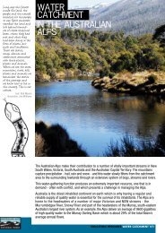
The Significance Of Mountain Catchments To Society The <strong>Australian</strong> <strong>Alps</strong> Catchments Roger Good<strong>National</strong> <strong>Parks</strong> and Wildlife Service, P.O.Box 2115, Queanbeyan NSW. 2620AbstractThe <strong>Australian</strong> <strong>Alps</strong> and high mountain ranges yield relatively small total amounts of water to ourstreams and rivers but as the driest inhabited continent on earth this small yield contributes much to thequality of life of almost all <strong>Australian</strong>s. As well as being the headwaters of the largest permanent flowingrivers in south-eastern Australia the catchments of the <strong>Alps</strong> and high mountains are also the catchmentfor thousands of tourists, bushwalkers and backpackers, and people seeking recreational, educationaland inspirational pursuits.As with other major continental mountain catchments around the world, the <strong>Alps</strong> and high mountaincatchments of south-eastern Australia (and Tasmania) are also ‘catchments’ for biological diversity andcentres of endemism, particularly that of the alpine plants. These mountains have also been the‘catchment’ for thousands of years for the ceremonial activities of Aboriginal people, and for the past 180years, European people, utilising the natural resources abundant in the high mountain and alpineenvironments. The mountain catchments play a very significant role in the social and economic wellbeingof <strong>Australian</strong> society.IntroductionMountain areas make up 24 percent of the earth’s land surface and support approximately 28 percent ofthe world’s closed forests. Some 550 million people live in high mountain areas around the world, beingan integral part of mountain environments. A further two billion people have a close affinity with orattribute some form of deity to high mountain peaks, or have some reliance upon mountains, particularlythe mountain catchments for drinking and irrigation water, hydro-electricity, recreation and education,and their physical well-being. Mountain areas around the world are usually considered in terms of beingthe headwaters of major rivers and the water yield they provide – the water towers of the world.But mountain catchments are more than water catchments, as they are ‘catchments’ for biologicaldiversity, plant and animal endemism, and significant ecosystem functions and environmental services.Mountains are also catchments for other cultural, recreational, spiritual, social and economic values.These values are a response to the very geographical features that define mountains – ruggedness,remoteness, extreme climates, soil and vegetation zonation and plant species diversity in both form andadaptation to the ecological extremes under which they have evolved.Mountain areas around the world usually constitute a relatively small proportion of river basins, yet theyprovide the greater part of rivers flows downstream. Like other continents this is also the situation inAustralia.Celebrating Mountains – An International Year of Mountains ConferenceJindabyne, New South Wales, Australia219
As the demand for fresh water increases, the potential for conflict over the source, yield and subsequentuse of water from mountain catchments grows. While there is no potential international conflict overwater resources in Australia, there is increasing conflict over the equitable sharing of water betweenenvironmental and commercial demands, and the sustainable use of water.In the past the grazing of domestic stock in the <strong>Australian</strong> alpine catchments resulted in extensivedisturbance and degradation of the native vegetation cover and over large areas, severe soil erosion.Grazing has now all but ceased in the alpine catchments, only occurring in several areas in the southernpart of the <strong>Alps</strong> in the State of Victoria.The grazing impacts have been replaced by the increasing development taking place within the mountaincatchments, to provide for tourism and recreational activities. This is placing a renewed pressure on thesoils, vegetation and water yields of the catchments. Management conflicts are increasing, hence carefulmanagement of mountain water resources must become a national (and global priority) in a world movingtowards a water crisis in the next century<strong>Alps</strong> catchments for water yieldThe world’s total freshwater reserves are in the order of 36 million Km 3 but the rivers and lakes ofAustralia, hold and carry only about 0.007 percent of this total fresh water ( 34.5 billion m 3 ), or less than9 percent of the annual flow of the Amazon.The high mountain catchments of southeastern Australia cover a little over 25000sq km with 5200sq kmbeing within alpine and subalpine elevations. (snow-covered for 1 to 3 months). These catchments arevery efficient in capturing and delivering to rivers and streams, over several months, up to 1000mm of theannual total precipitation of 1800 to 2500mm. The catchments yield the greater part (approx 65% or 8000to 10000 gigalitres) of the inflow to the Murray, Murrumbidgee and Snowy River systems. Of this wateryield, 3780 GL of the Murray River flows are diverted to off-river uses and 2350 GL from theMurrumbidgee River. The bulk of the water is used for irrigation (approx 95%) with the remainder beingused for stock and domestic requirements and for industrial use.The Murray River catchmentsThe Murray River has its source about 45 Kms southeast of Mt Kosciuszko. The major NSW tributaryrivers are the Swampy Plains River and the Tooma River which also arise in the <strong>Alps</strong>. The majorVictorian mountain tributaries are the Mitta Mitta River and the Kiewa River. The Hume Dam on theMurray River and Dartmouth Dam on the Mitta Mitta River above Hume Dam store and regulate thedownstream delivery of flows for irrigation, urban use and environmental purposes.The mountain catchments above Hume Reservoir cover less than 1.5% of the total Murray-Darling Basinbut yield about 38% of the total annual inflow to the Murray. About one third of the water yield is fromthe Mitta Mitta catchments in the Victoria alpine area and two thirds from the upper Murray catchmentsin the New South Wales alpine area. The total annual flow in the Murray is very low by world standards,for example the average annual flow is less than 3.5% of that of the Mississippi River and less than 0.25%of the Amazon. Approximately 66% of Murray River flows are diverted annually, providing water forirrigation over approximately 700000 ha. along the river downstream of Hume Dam.Murrumbidgee River CatchmentsThe Murrumbidgee River rises in the Snowy Mountains north of Mt Kosciuszko where the headwatersare captured by Tantangara Dam and diverted to Eucumbene Dam from which is released forhydroelectric generation through the Murray and Tumut River systems.The largest dam downstream of Tantangara Dam is Burrinjuck Dam, which stores, and regulates releasesof approximately 1026GL annually to the Murrumbidgee and Coleambally Irrigation Areas and severalsmaller adjoining irrigation areas. The major tributaries to the river above Burrinjuck Dam are theNumeralla, Bredbo Goodradigbee, Cotter, Molonglo and Yass Rivers. Below Burrinjuck Dam the major220Celebrating Mountains – An International Year of Mountains ConferenceJindabyne, New South Wales, Australia
tributary is the Tumut River which contributes natural flows and that diverted through the SnowyMountains Hydroelectric Scheme from the upper Murrumbidgee and Snowy Rivers, into Blowering Dam.This Dam stores 1628GL of natural river flows, and additional waters released from the Snowy-Tumutsection of the Snowy Mountains Hydroelectric Scheme.The irrigation agriculture industry is the greatest user of water from the regulated Murrumbidgee Riverwith the annual volume of water diverted for consumptive use being in the order of 2350gigolitres orapproximately 50% of natural flows. Approximately 2800 ‘irrigation’ farms, covering some 561000hectares occur within these irrigation areas, with around 150000 hectares being irrigated each year.At the lower end of the Murrumbidgee River the Lowbidgee Irrigation District covers an area of some400000 ha. encompassing a floodplain area in excess of 160000 hectares, including large areas ofsignificant riverine wetlands.Catchments for Hydro-electricity generationThe <strong>Alps</strong> and high mountain catchments provide water to two hydroelectric schemes, the SnowyMountains Hydroelectric Scheme in New South Wales and a smaller scheme, the Kiewa HydroelectricScheme in Victoria.The much larger Snowy Scheme has an installed capacity of 3740000 kilowatts with an annual output of5000 million kilowatt hours. It utilises almost 2500GL of water annually which is then stored andregulated for irrigation use.Social and Economic benefits of water diversionA very large and significant economic benefit accrues for the community from power generation and theagricultural production from the irrigation industries. The annual farm-gate returns from irrigationfarming in the Murray and Murrumbidgee Valleys are in the order of $1.8 to $2.5 billion annually. Theirrigation industries also contribute greatly to the quality of life and well-being of the rural and urbanpopulations (almost 300000 people) along the rivers, as well as those of Sydney, Melbourne andAdelaide, through the provision of many everyday food products.More than two million people depend directly on the Murray and Murrumbidgee Rivers for domesticwater supplies with a further 250000 dependent on the major tributaries for water supplies. SouthAustralia as the driest State is almost totally dependent on the Murray River for its further economicdevelopment.Over 50% of South Australia’s water is diverted from the Murray, and piped to Adelaide, Port Pirie, PortAugusta, Whyalla, the Yorke Peninsula and towns as distant from the river as Woomera and Keith. Indrought years up to 90% of South Australia’s water demands are met by diversion from the MurrayRiver.Hydro-electicity generated from waters captured in the <strong>Alps</strong> catchments contributes a small but verysignificant amount (approx 5000000 kilowatts) to the national electricity grid, this being valued atapproximately $175 to $250 million annually. The significance of the hydroelectric schemes lies not inthe dollar value of the electricity generated but the ready contribution the schemes make to peak loaddemands.The mountain catchments as such contribute greatly to the economic well-being of society but thecatchments are more than water catchments, being ‘catchments’ of significant biomes, native plantspecies diversity and endemism. They are also catchments of some unique plant and animal adaptations toextreme environmental conditions.Celebrating Mountains – An International Year of Mountains ConferenceJindabyne, New South Wales, Australia221
Mountain Catchment Biomes As with mountain areas around the world the <strong>Australian</strong> <strong>Alps</strong> biomes are unique – the combined effect ofrapid changes in altitude, climate, soil and vegetation over very short distances make them different fromother biomes. An indication of the extreme climatic variation exhibited in all mountainous areas is that arise in elevation of 100 metres is comparable to about 100 kilometres change in latitude. The rapid risein elevation is sufficient to produce altitudinal zonation in the vegetation communities, particularly thatevident in the zonation of the dominant Eucalypts, with different species occurring in defined elevationranges and aspects.Catchment biological diversityMountains are biologically diverse and of the 187 world centres of biological diversity more than halfoccur in mountain regions (Davis et al, 1995). The <strong>Australian</strong> <strong>Alps</strong> are identified as one of these centreswith more than 500 plant species occurring within the <strong>Alps</strong> catchments of which 380 occur in the alpineand subalpine zones.Plant endemism is high in all mountain regions around the world, (about 5%). but plant endemism in the<strong>Australian</strong> <strong>Alps</strong> at approximately 11% (Good 1992), is of particular note in comparison to othercontinental mountain regions. The <strong>Alps</strong> flora, particularly the alpine zone flora is unique on a world scaleas it differs greatly in botanical composition, the level of differentiation, species richness and internalbotanical zonation. Below the very diverse alpine zone the flora is dominated by a single genus(Eucalyptus), which has adapted to conditions from the highest elevations of the subalpine zone (thetreeline) to the coast; this adaptation to the full elevation range and environmental conditions by a singlegenus is unique in the world floras.The eucalypt woodlands, particularly at the higher elevations play a very significant role in the capture ofprecipitation and hence water yield, and in the stability of much of the mountain catchments.While the number of native fauna species is low, which contrasts with other continental mountain areas,eight fauna species are endemic to the alpine and subalpine zones. Several of these species have restricteddistribution ranges in the <strong>Alps</strong> catchments. eg Mountain Pygmy Possum Burramy parvus, CorroboreeFrog Pseudophryne corroboree and Broad-toothed Rat Mastacomys fuscus. The <strong>Alps</strong> catchments as suchcapture, protect and maintain a unique genetic resource, but mountain catchments are more than waterand biodiversity catchments; they are catchments for human enjoyment, recreational and educational use,and inspiration.Educational and recreational – catchment opportunitiesThe diversity of the mountain landscapes provide for a wide range of recreational, educational, culturaland inspirational opportunities. The <strong>Alps</strong> attract and capture some 3 to 4 million visitors each year inpursuit of these opportunities.The <strong>Alps</strong> have also been a catchment for much scientific research over the past 100 years and are nowarguably, the most researched natural area in Australia. Over 2500 scientific and technical papers havebeen written on research undertaken within the <strong>Alps</strong> and this research has contributed greatly toecological understanding and the establishment of principles for ecological sustainability in Australia.Environmental resources and benefitsThe natural systems of the <strong>Alps</strong> catchments are very significant and in many ways unique in the contextof world mountain areas. A defining feature of the <strong>Alps</strong> catchments is the well developed soil coverwhich exists over almost all areas, to the highest peaks. This deep organic soil cover of the alpine andsubalpine zones plays an important role in catchment hydrology.The groundwater communities, the fen and bog areas where deep organic peatbeds have developed, areparticularly significant in the storage and slow release of snowmelt waters to the streams and rivers and222Celebrating Mountains – An International Year of Mountains ConferenceJindabyne, New South Wales, Australia
ultimately to the hydroelectric schemes. The catchments are very stable under this complete soil andvegetative cover, but very minor impacts from external influences can lead to rapid deterioration of theecosystem services that they provide. In the lower mountain catchment areas where eucalypt forests andwoodlands dominate the landscape, the heavy ground litter layer provides a similar ecosystem service interms of water yield and water quality. The water yield from the catchments provides for thousands ofhectares of wetland watering and floodplain inundation downstream on the riverine plains. Theenvironmental services / benefits provided by functional natural wetlands have been estimated to bevalued at up to $1500 to $2000 per hectare or an estimated total economic benefit to society of up to $400million.Catchment managementCatchment stability and functionality are very sensitive to disturbance from factors, particularly wherethese are continuous or concentrated eg grazing, recreational activities, development sites, and changedfire regimes. Fire, due to the extensive nature of occurrence, poses the greatest threat to mountaincatchment stability and the natural ecosystem services they provide.Grazing has almost gone from the high mountain catchments but the increasing pressure of visitation andrecreational activities has replaced grazing as a major detrimental impact influencing the long-termfunctionality of catchments and the ecosystem services they provide.Several notable catchment rehabilitation and ecological restoration programs have been achieved over thepast 40 years (Good 1992, 1999) and the rehabilitated catchments must not be allowed to degrade againunder the pressure of human use. While the catchments are ‘catchments’, for water and human use themanagement of both without detriment to the natural catchment values is essential if society is to continueto benefit from the mountain catchments.Many lessons have been learnt from past inappropriate management and the successful rehabilitation /management programs and these must continually be addressed in future mountain catchmentmanagementSummary - mountain catchment valuesMountain catchments have many recognisable values and provide or contribute to many ecosystemservices of economic and social benefit to society. The value of maintaining and protecting mountaincatchments can therefore be recognised in a number of ways: through the natural physical features and biota, and the cultural history which provide for recreational,educational and inspirational opportunities. Mountain recreation and tourism is estimated to be valued at upto $750 million annually. in terms of the value of the water yield - water is now a tradeable commodity and at an average figure ofbetween $40 and $120 per megalitre, the catchments can be valued at a minimum of $400 to $500 millionannually, for water yield alone. in terms of the value of health and well-being of a large proportion of the community that utilise themountains, which is estimated to be in the order of $100 to $200 million annually. in terms of the value of hydroelectricity generated (up to $250 million annually) in terms of agricultural production from irrigation farming, valued at up to $2.5 billion annually in terms of ecosystem services - functional wetlands provided for by discharges from mountain catchmentsalone are valued at about $400 million annually in terms of the total economic and social benefits estimated to be in the order of $4.5 to $5 billion dollarsannually.Celebrating Mountains – An International Year of Mountains ConferenceJindabyne, New South Wales, Australia223
ReferenceDavis, S.D., Heywood, V.H. and Hamilton, A.C. (1995) (Eds). Centres of Plant Diversity. A guide andstrategy for their conservation. 3 volumes. IUCN Publications Unit Cambridge UK.Good, R.B. (1992) Kosciusko Heritage – The conservation significance of Kosciusko <strong>National</strong> Park.<strong>National</strong> <strong>Parks</strong> and Wildlife Service and Surrey Beatty and Sons, Sydney. 195ppGood, R.B. (1999) Rehabilitation and Revegetation of the Kosciuszko Summit Area: An historic review.In: Proceedings of 1998 <strong>National</strong> Conference of <strong>Australian</strong> Network for Plant Conservation.224Celebrating Mountains – An International Year of Mountains ConferenceJindabyne, New South Wales, Australia
Snowy Mountains Hydro-Electric Scheme: Corporatisation and the Way Ahead Nicole Shotter and Carol Bruce Nicole Shotter, Principal Snowy Hydro Liaison Officer, NSW <strong>National</strong> <strong>Parks</strong> and Wildlife ServiceCarol Bruce – EMP Project Manager, Snowy Hydro LimitedAbstractThe Snowy Mountains Hydro-electric Authority (SMHEA) was established as a Commonwealth statutoryauthority in 1949 to construct, operate and maintain the Snowy Mountains Hydro-electric Scheme, muchof which is located in the Kosciuszko <strong>National</strong> Park (KNP). From 1949 to 28 th June 2002, the schemeremained under Commonwealth control and was not subject to NSW legislation.As part of the national electricity market reform, in 1993 the Council of <strong>Australian</strong> Governments (COAG)thagreed to corporatise the SMHEA. On 28 June 2002 corporatisation was achieved, creating thecompany Snowy Hydro Limited (SHL).The activities of SHL have been subject to NSW legislation since 28 June 2002. With this in mind, aseries of agreements between the NSW <strong>National</strong> <strong>Parks</strong> and Wildlife Service (NPWS) and SHL weredeveloped through the corporatisation process of the past few years. These agreements, known as theKNP Package, are designed to provide a framework for the on-going management and operation of thescheme.The ongoing and future relationship between NPWS and SHL is firmly focused on managing the iconic<strong>Australian</strong> resource that is the Scheme in the equally iconic fragile mountain environment of KNP.thSnowy Mountains Hydro-Electric Authority And CorporatisationThe Snowy Mountains Hydro-electric Authority (SMHEA) was established as a Commonwealth statutoryauthority in 1949 to construct, operate and maintain the Snowy Mountains Hydro-electric Scheme, muchof which is located in the Kosciuszko <strong>National</strong> Park. From 1949 to 28 th June 2002, the scheme remainedunder Commonwealth control and was not subject to NSW legislation.As part of the national electricity market reform, in 1993 the Council of <strong>Australian</strong> Governments (COAG)agreed to corporatise the SMHEA. On 28 th June 2002 corporatisation was achieved, creating thecompany Snowy Hydro Limited (SHL).The activities of SHL have been subject to NSW legislation since 28 th June 2002. With this in mind, aseries of agreements between the NSW <strong>National</strong> <strong>Parks</strong> and Wildlife Service (NPWS) and SHL weredeveloped through the corporatisation process of the past few years. These agreements, known as theCelebrating Mountains – An International Year of Mountains ConferenceJindabyne, New South Wales, Australia225
KNP Package, are designed to provide a framework for the on-going management and operation of thescheme.The KNP Package includes: Snowy Park Lease and Schedule of Existing Developments (administered by Planning NSW); Snowy Roads Maintenance Agreement; Snowy Management Plan; Minor Former Scheme Sites Deed; and Major Former Scheme Sites Management DeedIn addition to the KNP Package, approximately 35 documents were developed as part of thecorporatisation process in various other packages: Corporate Package Water Package Debt Package Tax Package Transfer Orders Transmission Undertaking Package Blowering Package Miscellaneous PackageOf particular interest is the Water Package, which includes the Snowy Water Inquiry Outcomes. TheSnowy Water Inquiry Outcomes include the return of environmental flows to the Snowy River belowJindabyne Dam and montane streams within KNP. The Department of Land and Water Conservation isthe NSW agency responsible for administration of the water agreements.Of the KNP Package, the Snowy Park Lease and Roads Maintenance Agreement are principallycommercial documents.The Snowy Park Lease provides tenure for SHL’s operations and in association with a Schedule ofExisting Developments (SED) details all of the scheme’s current developments and activities. Allactivities listed within the SED are ‘deemed’ by the Snowy Hydro Corporatisation Act 1997 (NSW) tohave complied with <strong>Part</strong> 5 of the Environmental Planning and Assessment Act 1979 (NSW). SHLtherefore do not require approval from the NPWS to undertake the activities listed within the SED.The Roads Maintenance Agreement provides for the maintenance arrangements of those roads used bySHL within the park, whether they may be public, park management or snowy exclusive roads. Theagreement includes a set of road maintenance guidelines which detail how both organisations mustundertake road maintenance works on roads listed in the agreement.The remainder of the documents in the KNP Package, the Snowy Management Plan and two formerscheme site deeds, are the focus of this paper and are presented in detail below.Each of the day to day operational documents between NPWS and SHL (Lease, Roads Agreement andSnowy Management Plan) has an associated committee, comprised of NPWS and SHL personnel. Therole of each of the committees is to guide the ongoing relationship between NPWS and SHL and manageany issues as they may arise. The committees aim to continue the cooperative working relationship thathas been established between NPWS and SHL in past years.226Celebrating Mountains – An International Year of Mountains ConferenceJindabyne, New South Wales, Australia
Snowy Management PlanThe Snowy Management Plan (SMP) is a plan of management under <strong>Part</strong> 5 of the <strong>National</strong> <strong>Parks</strong> andWildlife Act 1974 (NSW) and recognises that the current Kosciuszko <strong>National</strong> Park Plan Of Management(KNP POM) did not adequately provide for the existence and operation of the scheme within the park.The SMP and KNP PoM are related documents and reviews of either must recognise the content of theother. The SMP however, deals exclusively with the operation of SHL in the park.The SMP places general obligations (with respect to maintenance of developments and fire response) onSHL as well as the obligation to develop an environmental management plan (EMP). The purpose of theEMP is to address how SHL will environmentally undertake the activities listed within the SED ie thoseactivities ‘deemed’ to comply with <strong>Part</strong> 5 of the EPandA Act, commensurate with the location of theactivities within a national park.The EMP must: contain clear accountability for its implementation; demonstrate that an environmental assessment identifying environmental risks has been undertaken and asubsequent programme for risk reduction has been implemented; and demonstrate that a performance monitoring programme is in place.In addition, SHL must: base the EMP on sound and credible information; improve the EMP; and with NPWS, monitor the effectiveness of the EMP. The EMP is to be a 15 chapter plan which will be developed by SHL and reviewed and approved by NPWS. Development is to be staggered over the next three years, with all chapters completed and implemented by June 2005. The EMP requires SHL to detail how it will meet environmental obligations and responsibilities for the 15 chapter issues. The NPWS will be able to enforce the approved EMP through an associated regulation. The existing <strong>National</strong> <strong>Parks</strong> Regulation 2002 (NSW) may also be applied to SHL activities within the park. The 15 chapter headings of the EMP are: Aboriginal Heritage Aircraft Management Emergency Management (including fire management) Exotic Species (flora and fauna) Historic Heritage Public Health Water Quality Threatened Species and Significant Features Tourism, Recreation and Public Use Cabramurra Tunnel/aqueduct maintenance including desilting Road Maintenance Operational spoil dumps and quarries Landscape (including soil and vegetation management)Celebrating Mountains – An International Year of Mountains ConferenceJindabyne, New South Wales, Australia227
General environmental managementFor each EMP chapter, the SMP details the NPWS management objectives for the scheme and theminimum content required in the first draft of the chapter (refer to Figure 1). Where possible, thechapters focus on NPWS and SHL cooperative activities. These activities are generally aimed atimplementing Park wide strategies for the various issues.This approach is highlighted in the exotic species chapter with the requirements for SHL to develop: a strategy to manage noxious and environmental weeds in accordance with NPWS priorities and strategies; a statement of NPWS and SHL cooperation with respect to exotic species management; and notification procedures between NPWS and SHL.To ensure the final content of the chapters provides the maximum benefit to both NPWS and SHL,development of the chapters is being undertaken in a cooperative manner. Both organisations havedeveloped small dedicated teams for each individual chapter and these teams meet and communicate asrequired.As adoption of the EMP is to be staggered over the first three years of corporatisation, the SMP alsoplaces interim obligations upon SHL with respect to ‘deemed’ activities. These obligations stipulate thatfrom the date of corporatisation until approval of the relevant EMP chapter, SHL must comply with alllaws and accepted current practices.To ensure that the EMP remains relevant, the SMP stipulates a time frame and process for the subsequentreviews of each chapter. The timing of the review process varies based upon the subject matter of theindividual chapter. For example, the chapters on emergency management, public health and water qualitymust be reviewed every second year. In comparison, the chapters on operational spoil dumps andquarries, and general environmental management need only be reviewed every ten years. Provision hasalso been made for chapters to be amended more frequently should both NPWS and SHL agree that suchan action is required.All new activities proposed by SHL, ie any activity that is not listed within the SED, must be the subjectof an application for approval in accordance with the requirements of any applicable law.228Celebrating Mountains – An International Year of Mountains ConferenceJindabyne, New South Wales, Australia
Figure 1: Exotic species (flora and fauna) EMP chapter outlineChapter4:ExoticSpecies(FloraandFauna)General1. To control and contain the spreadof exotic species within the Areas.2. To prevent the replacement ofnative species by exotic specieswithin the Areas.Fauna3. To reduce the impact of pestanimals on native animals and theirhabitat, and native flora in the Areas.4. To minimise disturbance,destruction and displacement ofnative fauna by exotic fauna in theAreas.Flora5. To contain and control the spreadof weed species in the Areas.6. To minimise loss of habitat forfauna species within Areas.1. A summary of:a) the Laws applicable to the containment and control ofexotic species, pest animals and weeds species within theAreas; andb) the noxious and environmental weed species within theAreas.2. A strategy to control and manage noxious andenvironmental weed species in the Areas developed inaccordance with NPWS weed management priorities andstrategies within the relevant management units.3. A strategy to minimise and control the planned andaccidental introduction of exotic flora species into theKNP that:a) Specifies procedures to minimise disturbance to thenatural environment within the Areas when the Companycarries out operations including road works, quarrying,construction and maintenance;b) Includes an appropriate revegetation policy for theAreas; andc) Includes procedures for minimising chanceintroductions of plant materials or pathogens, includingprocedures for machinery wash down and the use of seedfree materials.4. A plan for the control of exotic fauna within the Areasthat specifies:a) the procedures the Company will adopt to identify,minimise and control exotic fauna species includingrabbits, starlings, goats, deer, non-native rats, house mice,foxes, cats and oriental weather loach; andb) the Company’s participation in co-operativemanagement of trout in any conservation streamsspecified by NPWS.5. A statement as to how NPWS and the Company willcooperate in relation to the management of exotic species.6. Notification procedures between NPWS and theCompany with respect to all the matters above.Celebrating Mountains – An International Year of Mountains Conference 229Jindabyne, New South Wales, Australia
Former Snowy Scheme Sites The corporatisation project identified numerous former scheme sites within the park. These sites haveresulted from the construction period of the scheme and the majority still require some form ofrehabilitation. Required rehabilitation ranges from the need to remove a snow pole to extensivegeotechnical rehabilitation of large spoil dumps and quarries.Of the 400 or so former sites, 36 have been designated as ‘major’ sites requiring extensive rehabilitation.The remainder are designated ‘minor’ sites and require rehabilitation to a lesser degree. A major site isgenerally one that may potentially breach NSW legislation. Minor sites are not thought to breach NSWlegislation.During the corporatisation process, the three corporatisation governments (State of New South Wales,State of Victoria and the Commonwealth of Australia) agreed that NSW and more specifically NPWSwere responsible for managing the land and any rehabilitation works required, and for any liability arisingfrom either major or minor former sites. The exception is any liability arising under the ContaminatedLand Management Act 1997 (NSW) due to the scheme’s occupation of the site, for which SHL retainsresponsibility.The minor sites category includes areas such as snow courses, weather stations, passive reflectors, radiostations, communication cables, roads, transmission lines, former works centres/depots, formertownships/camps/construction sites, sandblasting areas, waste disposal areas, borrow pits, quarries andspoil dumps.The predominant issue on minor sites is weed invasion, however other issues such as waste removal,erosion and native revegetation will need to be addressed on many sites. NPWS operational staff andcontractors will undertake the rehabilitation of minor sites.The major sites category includes areas such as spoil dumps, quarries, a former township and a wastedisposal area. An independent investigation designated the major sites as potentially breaching NSWlegislation. Issues identified include stability, erosion and sediment transport, hydrology, watercourse,water quality, flora and fauna, noxious and environmental weeds, solid waste, heritage, visual amenity,access during rehabilitation works, safety during rehabilitation and disposal/importation of material.The investigation suggested an initial estimate of $78 million as the cost to rehabilitate the major sites toan agreed level based on what rehabilitation could potentially be undertaken in a practical sense. TheNSW and Commonwealth agencies involved in the investigation acknowledged at the time that it wouldbe extremely difficult and require an extensive financial input to rehabilitate the sites back to a standardcommensurate with the surrounding national park.As part of the corporatisation process, SHL is required to pay the NPWS $32 million towards therehabilitation works for both major and minor sites; $25 million for major sites and $7 million for minorsites.The difference between the potential original rehabilitation costs and the funding actually received posesa significant challenge for NPWS. The challenge will be to develop a program for the major sites thatwill achieve the best environmental outcome possible for the park within the funding available. It isproposed to meet this challenge by undertaking a risk assessment of the major sites as an overall projectand basing any rehabilitation works on the results of that assessment.Due to the size and complexity of the major sites, a dedicated project team will most likely be establishedto manage the project. In addition to NPWS, other relevant NSW agencies such as Department of Landand Water Conservation, Department of Fisheries, Environment Protection Authority will be involved asrequired.Both the minor and major site rehabilitation projects will focus on long term rehabilitation, endeavouringto achieve the best environmental outcome possible across the full range of sites, on the funding provided.230Celebrating Mountains – An International Year of Mountains ConferenceJindabyne, New South Wales, Australia
A case study of both minor and major sites, and the range of issues and potential rehabilitation worksrequired, is provided by the Happy Jacks group of sites. The Happy Jacks area is located approximatelyin the centre of KNP, approximately 2.5 km north of the Jagungal Wilderness area. Five major sites andfour minor sites are located immediately adjacent to the Happy Jacks management trail.The major sites include four spoil dumps and one quarry. Each of the spoil dumps contains materialexcavated during construction of the Happy Jacks Shaft and Eucumbene-Tumut Tunnel between 1954and 1959. The spoil dumps range from a vertical height of approximately 30m to approximately 70m.The largest spoil dump has an estimated spoil volume of 300,000 m 3 . The Happy Jacks Quarry, with anarea of approximately 3 hectares, was used to manufacture aggregate for Tumut Ponds Dam, theEucumbene-Tumut Tunnel, and the Tumut 1 Pressure Tunnel, also between 1954 and 1959.Issues identified on the four major spoil dumps and single quarry include geotechnical stability, erosionand material transport, on-site hydrology, lack of native revegetation, lack of appropriate material topromote revegetation, weed invasion, watercourses obstruction, potential water quality issues, solidwaste, heritage. In addition, associated issues such as access to sites, safety during rehabilitation, materialrequirements/disposal and data limitations will need to be addressed.The minor sites include one spoil dump also formerly used as a crusher site by NPWS, a former townshipand two borrow pits. Issues identified include erosion and surface water run-off (spoil dump), lack ofnative vegetation growth (spoil dump and borrow pits) and weed invasion (all sites).Rehabilitation of the major sites and any non-weed issues on the minor sites will likely be undertaken as asingle project. The first stage in the planning of the major sites rehabilitation project will be for a riskassessment of all sites to be undertaken. The rehabilitation strategy that is ultimately implemented mustbe based on a risk assessment approach. Based on such a strategy, there is a potential that largegeotechnical works will not be undertaken on the majority of the larger spoil dumps and quarries.Rehabilitation may instead be required to focus on ensuring long term stability of the site, weedmanagement and encouragement of vegetation growth. A large component of the project will likely belong term monitoring of the sites.The Way AheadThe relationship between NPWS and SHL is two tiered with NPWS playing the role of both lessor andregulator. To ensure that this relationship works and produces the best environmental outcomes for thepark at the same time as the best possible outcomes for the business of SHL, open communicationbetween the two organisations is vitally important at all levels. Both organisations recognise theimportance of ensuring the long term viability of the park and the scheme within the park.The ongoing and future relationship between NPWS and SHL is firmly focused on managing the iconic<strong>Australian</strong> resource that is the Scheme in the equally iconic fragile mountain environment of Kosciuszko<strong>National</strong> Park.Celebrating Mountains – An International Year of Mountains ConferenceJindabyne, New South Wales, Australia231
232Celebrating Mountains – An International Year of Mountains ConferenceJindabyne, New South Wales, Australia
Thatching The Roof Of Australia: Landscape Manipulation And History Dr Michael PearsonHeritage Management ConsultantsAbstractThe conservation of the Main Range area in what is now the Kosciuszko <strong>National</strong> Park had its genesis, inthe large part, in the movement to protect the catchments arising in the NSW <strong>Alps</strong>. The interests of theNSW Soil Conservation Commission, the nature conservation movement and the Snowy MountainsAuthority converged to drive the moves towards grazing restrictions, erosion control and rehabilitation,and national park gazettal over a thirty year period.The ways in which the history of this long process is recorded and interpreted to visitors to the park, andhow the physical evidence of the process are conserved and interpreted, are issues of interest whenconsidering the assessment and management of cultural heritage values of the <strong>Alps</strong>. The manipulation ofthe landscape to achieve stable catchments is a matter of fact—the manipulation of the history of thatprocess to hide the role of the human hand in the creation of the current landscape is an ongoing threat.BackgroundThis paper, which concentrates on the Main Range within Kosciuszko <strong>National</strong> Park, is based on workundertaken for the <strong>Australian</strong> Heritage Commission to develop a nomination for the Snowy MountainsScheme for the Register of the <strong>National</strong> Estate 1 . The generosity of Roger Good in sharing his greatknowledge and memory is gratefully acknowledged.1Pearson, M and Marshall, D. 2000. ‘Snowy Mountains Scheme: Scoping study of the European cultural heritage’, unpublished reportfor the <strong>Australian</strong> Heritage Commission. Pearson, M. and Marshall, D. 2001. ‘Snowy Mountains Scheme: Nomination report: Registerof the <strong>National</strong> Estate and <strong>National</strong> List’, report for the <strong>Australian</strong> Heritage Commission.Celebrating Mountains – An International Year of Mountains ConferenceJindabyne, New South Wales, Australia233
Map 1 - The Main Range showing the location of the treeline (roughly equating with area of soil conservation work)234Celebrating Mountains – An International Year of Mountains ConferenceJindabyne, New South Wales, Australia
Snow Lease Paddock To Protected CatchmentGraziers were sending stock into the Snowy Mountains from at least the mid-1830s. Dr Gibson lost astockman and cattle to a blizzard in the Kiandra area in 1834, and in 1839 T.A. Murray moved cattle fromhis Yarralumla property through the Brindabellas to the high plains around Coolamine 2 . Summer grazingin the higher snow country became desirable from the mid-1860s, as stock numbers in the surroundingdistricts grew. By the mid-1880s the mountains could be described by one observer during a dry summeras ‘overcrowded with sheep’. Cattle were increasingly taken into the mountains, able to be run on steepercountry than the sheep, and it was mainly cattle that were responsible for the degradation of the MainRange. The grazing was not officially regulated until the passing of the 1889 Crown Lands (Amendment)Act, in which snow leases were established. By 1893 some 81,000 acres of country adjacent to MountKosciuszko was divided into 22 snow leases 3 .The Main Range land surface is commonly covered with loose soil and stones. The soil, thicker than inmany other alpine environments, is derived from decomposed granitic rocks and is highly erodable. Theelevated exposed location slows and limits plant growth, so that any disturbance of vegetation tends totake a very long time to recuperate. These factors, combined with the considerable slope of much of theland and the prevalence of summer rainfall delivered in heavy downpours, means that exposed soil israpidly eroded. Once freed of its insulating blanket of vegetation, the soil is far more prone to frost-heavewhich in turn accelerates erosion.Map 2 - Scale of cattle movements in 1954-55 season23Hancock, W.K. 1972. Discovering Monaro: a study of man’s impact on his environment, Cambridge University Press, London: 132.Hancock 1972: 136Celebrating Mountains – An International Year of Mountains ConferenceJindabyne, New South Wales, Australia235
The freeze-thaw cycle also disturbs seedlings, making it very difficult for bare areas to revegetatenaturally. 4The impact of grazing on the environment of the Main Range was enormous, with stock grazing thenative vegetation, trampling and causing drying and erosion of the moss beds and bogs, introducingexotic weeds, and through all this enabling the substantial loss of topsoil through erosion. By the 1940sthe high country had large areas of grazed land marked by sheet erosion, and with deep erosion gulliesmarking the habitual routes of stock movement and of tracks cut by the stockmen’s horses.A number of converging interests combined to promote the conservation and landscape rehabilitation ofthe Main Range area. Myles Dunphy had been leading a campaign since the 1930s to have a ‘Snowy-Indi<strong>National</strong> Park’ created, based on the nature conservation and wilderness values of the area. Schemes toutilise the rivers of the regions for hydro-electric power generation and irrigation purposes went back tothe nineteenth century, and were gathering strong support during the early 1940s. The creation of theHume Weir and reservoir on the Murray River in 1936 led to the first direct moves to protect the uppercatchments of the river through their reservation as state forests. 5Utilisation of the upper Snowy River became a policy platform for the NSW Parliament opposition in1941, and when William McKell became Premier later that year the protection of the Snowy Mountainscatchments became a government priority. The head of the Soil Conservation Commission, E.S. (Sam)Clayton, was instrumental in formalising the direction of this policy. Clayton took McKell and theMinister of Lands, J. M. Tully, for a two-week ride through the Snowy Plain area on the Gungarlin River,to stress to them the damage that would be done if a closer settlement proposal then being promotedshould go ahead. Clayton argued for the cessation of grazing leases and the transfer of the area to a Boardunder the Department of Lands administration.McKell’s immediate response was to instruct Clayton to use the forthcoming review of leases (in June1943) to achieve a two-thirds reduction in the stocking rate in the high country and to decide a safecarrying capacity for each lease and permissive occupancy 6 . A Bill for the creation of a State Parkfollowed shortly afterwards. The park idea has been credited in part to the influence of the Director ofPhysical Education, Gordon Young, who saw it as an opportunity to create a protected playgroundcomparable with Jasper <strong>National</strong> Park in Canada, but the genesis of the idea leads back to MylesDunphy’s campaign 7 .On introducing the Bill in 1944, Minister Tully emphasised three principles:the permanent preservation of all water catchments in the Park;the permanent reservation and development of the Park for recreation and the enjoyment of the people; andthe controlled use of the park for pastoral purposes, consistent with the first two principles.From 1944 onwards the battle to remove grazing from the park was fought mainly from a catchmentprotection perspective, though strongly supported by the nature conservation objective. Ironically, theState Park Trust argued for the continuation of the high altitude snow leases in the face of mountingopposition, because lease fees was one of the few sources of revenue available to it through theDepartment of Lands.A key factor reinforcing the need for catchment protection and rehabilitation was the advent of the SnowyMountains Scheme, and of the Snowy Mountains Authority which had the political clout and financialresources to implement its objectives. The long history of plans for hydro-electricity and irrigation water4 see for example: Kosciusko State Park Trust, 1963. Preservation of vegetation and prevention of soil erosion within Kosciusko StatePark, Kosciusko State Park Handbook no. 1, Kosciusko State Park Trust, Sydney. Bryant, W.G. 1971. ‘Deterioration of vegetation anderosion in the catchment area, Snowy Mountains, NSW’, Journal of the Soil Conservation Service of NSW, 27 (1): 62-81. Durham,L.J. 1959. ‘Indicators of land deterioration in the Snowy Mountans catchments’, Journal of the Soil Conservation Service of NSW, 15 (3and 4). (reprinted by the Soil Conservation Service of NSW, 1960).5 see Mosley, G. 1992. ‘Conservers of the <strong>Australian</strong> <strong>Alps</strong>’, in Scougall, B. (ed) Cultural heritage of the <strong>Australian</strong> <strong>Alps</strong>—proceedings ofthe symposium held at Jindabyne, New South Wales, 16-18 October 1991, <strong>Australian</strong> <strong>Alps</strong> Liaison Committee, Canberra: 19-35.Wigmore, L. 1968. The struggle for the Snowy: The background of the Snowy Mountains Scheme, Oxford University Press,Melbourne.6 Mosley 1992; 23-24.7 Mosley 1992; 24.Celebrating Mountains – An International Year of Mountains Conference236Jindabyne, New South Wales, Australia
systems in the Snowys resonated in the context of planning for post-WWII reconstruction. TheCommonwealth Government in 1946 directed officers of the Departments of Works and Housing andPost-War Reconstruction to investigate the proposal put forward by O.T. Olsen of the State ElectricityCommission of Victoria. The recommendations of that investigation led to the setting up in late 1947 ofthe Commonwealth / States Technical Committee to pursue the proposals for utilising the waters of theSnowy and Murrumbidgee for power generation and irrigation. The key aspects of post-warreconstruction, of which the Snowy Scheme was to be a major component, were to include: the maintenance of full employment by judicious use of public works, of which the Snowy Scheme was tobe the prime example; the promotion of economically viable agriculture (while placing 9,000 ex-servicemen on the land), of whichthe Snowy-fed irrigation schemes were a part; bolstering manufacturing by tariff barriers, but also by facilitating the required infrastructure, such as aguaranteed power supply substantially augmented by the Snowy Scheme; and the use of immigration to stimulate overall development, targeting continental Europeans, many of whomwent straight to the Snowy Scheme. 8After much debate and political posturing by the states about the various options for the extent of thescheme, a plan was finally adopted by the Committee in November 1948, and the recommendations of itsreport were approved by the relevant Governments in July 1949. 9 .. The Commonwealth’s SnowyMountains Hydro-Electric Power Act came into force on 7 July 1949, bringing into being the SnowyMountains Hydro-Electric Authority (SMHEA) 10 .William (later Sir William) Hudson and the other Commissioners of the new Authority were keenlyaware of the risk to the Scheme from siltation of its dams, and took action to reduce erosion fromconstruction sites by cleaning them up after use.Sam Clayton worked closely with the Authority, and Hudson, to broaden their understanding of theerosion issue, and it is this prompting that led to Hudson’s strong support for the cessation of grazing inthe high country. The two men combined in the campaign to stop renewal of leases in the high altitudeareas (above 1370 m) in 1958. The SMHEA overcame the State Park Trust’s reluctance to forgo therevenue from snow leases by making up the cash shortfall, though in a clever twist it was agreed that theAuthority’s contribution would be transferred from the State Park to the Soil Conservation Commissionto do erosion control and rehabilitation work in the Park. 11The success over the snow lease issue, however, was not the end of grazing—the State Park did not havethe staff to patrol the park, and the ban was virtually ignored by many graziers. It was not until 1969 thatgrazing was finally made illegal within the Park, when the new <strong>National</strong> <strong>Parks</strong> and Wildlife Act, withstronger land management teeth, came into force, 12 and the last leases were not terminated until 1972.Erosion Control and RevegetationThe history of rehabilitation and revegetation of the high country has been one of trial and error 13 . Workby the Soil Conservation Commission (SCC) started in a small way in 1959, and increased considerablyby 1962, funded by the SMHEA contribution to the State Park coffers, which were transferred to the SCCprograms. Initial surveys found that some 5,560 hectares of minor to severe sheet erosion occurred along8 Sheridan, T. 1998. ‘Postwar reconstruction’, in Davison, G. Hirst, J, and Macintyre, S. (ed) 1998. The Oxford Companion to <strong>Australian</strong>History, Oxford University Press, Melbourne: 521-522; Pearson and Marshall 2001.9 see Wigmore, L. 1968. The struggle for the Snowy: The background of the Snowy Mountains Scheme, Oxford University Press,Melbourne; Seddon 1995: 32-33.10 Collis, B. 1998. Snowy: The making of modern Australia, Tabletop press, Canberra 37.11 Hancock 1972: 164-181.12 Seddon, G. 1995. Searching for the Snowy: an environmental history, Allen and Unwin, Sydney: 38. also see Hancock 1972: 165.Good R. 1996. ‘History of the Soil Conservation Service summit area works program—Kosciusko <strong>National</strong> Park’, in Proceedings of theConference of Soil and Water Conservation Association of Australia, Cooma, 1996. (revised in 2000 for the ANPC Conference,Lismore)13 based on Good 1996 and personal communication 29/9/00.Celebrating Mountains – An International Year of Mountains ConferenceJindabyne, New South Wales, Australia237
the Main Range between Dead Horse Gap and the Schlink Pass Road, the worst areas being between MtKosciuszko and Mt Twynam. 14Initial attempts utilised standard soil conservation solutions developed for agricultural lands, involvingcontour banks and drains, rock-paved drains, and the sowing of European exotic grasses and clovers. Therehabilitated area was fertilised, and mulched with sterilised hay, which was held down with galvanisedwire netting pegged into place. The first area worked on, and most effected by this technique, was aroundCarruthers Peak, where evidence of the approach can still be seen on many slopes. It was found that thehigh fertiliser rate inhibited the growth of native species adapted to low-nutrient levels, and actuallycaused native species to die back from the revegetation areas. The mulch, if applied too early in theseason, insulated the soil and prevented its warming, inhibiting germination of seed, and the highhumidity in the mulch contributed to fungal growth which attacked native seed. It was later found thatanother problem with the method was the release into the soil of zinc from the galvanised wire netting,causing zinc toxicity in soils with normally a very low level of the element 15 . Early experiments on theslopes of Mt Carruthers also investigated the potential of tree propagation. A plot of Pinus mugo wasplanted, stunted specimens of which survived for 30 years before their removal.Figure 1 - Stone-lined contour bank and drain on Main Range walking track, Carruthers Peak, 200214 Irwin, F. 1991. Above the treeline: how the high country was rescued, Soil Conservation Service of NSW, Sydney.15 Good 1996Celebrating Mountains – An International Year of Mountains Conference238Jindabyne, New South Wales, Australia
By the late 1960s it was recognised that the use of exotic species was not a viable long-term solution inthe high country, neither practically nor philosophically. Native plant propagation trials started in 1967,and between 1969 and 1972 some 500,000 peat pots of montia (Neopaxia spp) were over-planted onstabilised areas. It was then found that direct planting of small amounts of sod was just as successful asplanting propagated stock, and later still that seeded mulch also worked.Figure 2 - Contour banks and stone-lined channel on an eroded area of Carruthers Peak, 2002Improved techniques were introduced as the soil conservation and revegetation work moved slowly northalong the Main Range in the period between 1959 and 1973. The overall area needing such workextended from Mt Kosciuszko to the Bulls Peak area 35 km to the north, and 10 km east to the Ramsheadand Perisher Ranges. New methods of holding down the mulch were tried, including black steel mesh,paper netting, plastic polymers, biodegradable nylon netting and water soluble anionic bitumen. Thelatter proved to be the best solution, consolidating the mulch long enough for the enclosed seed togerminate and become established, then breaking down over two or three years. The use of rock drainsand dams in eroded water courses was replaced where feasible with jute mesh and sod laying 16 .The Carruthers Peak area was revisited late in the program, and some areas of wire mesh were removed,and native species over-planted. Most exotics have now disappeared and been replaced by natives,though some white clover and exotic fescues survive, and Caucasian clover has become a pest species 17 .The mark of successful soil conservation and revegetation work is that it is not noticed, and this isgenerally the case with the high country rehabilitation works. Apart from rock-work in erosion gullies(most of which is now buried by siltation), most rehabilitation work is invisible to the casual observer.However, the evidence is still there to be seen in the landscape if the right information is provided to theobserver.In a number of areas, but on Carruthers Peak in particular, can be found areas with decaying wire andlater fabric netting, revegetated contour drainage banks, some stone lined, still visible on the slopes, andthe many steel stakes used as monitoring reference points. These features are clearly seen, for example,from the Main Range track above Blue Lake and across Carruthers Peak.16 Roger Good, pers comm 29/9/0017 Roger Good, pers comm 29/9/00Celebrating Mountains – An International Year of Mountains ConferenceJindabyne, New South Wales, Australia239
The landscape has been stabilised, but, as Roger Good points out:‘…it will be many years before the full diversity of native species is to be found ineach rehabilitated vegetation community. In a number of sites, such as the erosionfeldmark areas, stable feldmark-like communities have replaced tall alpine herbfieldcommunities. Thus these changes have led to the creation of a mosaic of vegetationcommunities somewhat different to the pre-grazing communities. While a stablenative vegetation does exist in the restored fen and bog communities it will bedecades before these bogs and fens recover their functional capacity in terms ofgroundwater storage and slow release of water to the streams and rivers. 18Good also points out that maintenance of the rehabilitation work, necessary for the long-term recovery ofthe alpine areas, has lapsed over the last five to ten years, leading to decline in the native vegetationcover, and the start of active erosion in a few locations.Acknowledging the history of conservation on the Main RangeFrom the heritage assessment viewpoint, the substantial erosion control and revegetation work along theMain Range has considerable historical significance. It represents a major shift in soil conservationthinking in coming to grips with an <strong>Australian</strong> environment and conserving it rather than manipulating itwith exotic species. The work is an important part of the overall Snowy Mountains Scheme, and indicatesthe degree of concern for catchment protection associated with the Scheme’s development. It also isindicative of shifting public and, more importantly, political attitudes to the protection and appropriateuse of natural environment areas of high heritage value.The soil conservation work has had a major impact on the alpine landscape, though most observers wouldnot be aware of it without access to the historical information that makes the signs visible. The work hasput a bandaid on the wounds inflicted by grazing, but the underlying scar will take much longer to heal.The simplistic interpretation of the program is that it has returned the Main Range to its natural state.However, this is clearly not the case. The area will never be in the state it was in before grazing, though itwill eventually develop the species diversity and ecological and hydrological processes that replicate thatstate to varying degrees.In a manner similar to the often blinkered interpretation of wilderness, there is a risk that the Main Rangemay be interpreted to the public as a ‘natural’ area, and the history of degradation and rehabilitation willbe ignored or glossed over. The Main Range is not part of a gazetted wilderness area, but the parallels inthinking are worth considering. The identification of an area as ‘wilderness’ often results in a conceptualand management position that defines an area of land as being devoid of human history and havingevolved in the absence human processes, regardless of the demonstrated facts about the human use of thearea. Aboriginal landuse practices are simply regarded as part of the ‘natural’ state, regardless of theextent of ecological impact it may have had. Evidence of ‘modern’ human landuse is either ignored oractively removed. Tom Griffiths has argued that the definitions of ‘wilderness’ rely at their core on thelook and feel of an area, and that ‘ … “wilderness” need not be actually ancient, pristine and timeless; itjust needs to seem so.’ 19In the case of the Main Range, the undoubted scenic beauty and high natural values of the high countrydominate the conceptualisation and interpretation of the area. In that context the historical processes thathave led to the present character of the Main Range could be overlooked as irrelevant distractions, orworse, could be actively suppressed in the interpretation of the area to visitors. This tension betweennatural history and cultural history, and natural conservation and cultural conservation, has been exploredby others 20 .18 Good 1996; see also Chapter 7 of Good, R. 1992. Kosciusko Heritage: the conservation significance of Kosciusko <strong>National</strong> Park,<strong>National</strong> <strong>Parks</strong> and Wildlife Service of New South Wales, Sydney.19 Griffiths, T. 1996. Hunters and Collectors—The antiquarian imagination in Australia, Cambridge University Press, Melbourne: 260.20 Griffiths 1996: 255-277. Mulvaney, J. 1992. ‘The alpine cultural heritage in perspective’, in Scougall, B. (ed) Cultural heritage of the<strong>Australian</strong> <strong>Alps</strong>—proceedings of the symposium held at Jindabyne, New South Wales, 16-18 October 1991, <strong>Australian</strong> <strong>Alps</strong> LiaisonCommittee, Canberra: 9-17. Lennon, J. 1989. ‘Timeless Wilderness? The use of historical source material in understandingenvironmental change in Gippsland Victoria’, in Frawley, K.J. and Semple, N. (eds), Australia’s ever changing forests: Proceedings ofthe First <strong>National</strong> Conference on Forest History, <strong>Australian</strong> Defence Force Academy, Campbell: 419-440.240Celebrating Mountains – An International Year of Mountains ConferenceJindabyne, New South Wales, Australia
In trying to see how NPWS is dealing with this tension, I looked at what information about the landusehistory and rehabilitation of the Main Range was readily available to the visitor at the NPWS Jindabyneheadquarters visitor display, at the Charlotte Pass car park, and on the Main Range Track. Theinterpretation panels at the Jindabyne Visitors Centre included information about the history and impactsof grazing, but nothing about the post-grazing soil conservation rehabilitation work. Similarly, the NPWSleaflets and brochures available there contained no information about the post-grazing rehabilitationwork. 21 Upon asking the very helpful counter staff if anything on the Main Range soil conservation workexisted, I was given a very informative and well illustrated brochure put out by the Soil ConservationService of NSW, 22 but this came from the inside storeroom, and was not available to the passing visitor.At the information shelter at Charlotte Pass, where the track to the Main Range starts, one panel had someinformation and one photograph about the soil conservation work, but nothing to link this informationwith what the walker would see on the track. On the track itself there was no information that mentionedthe thirty-year rehabilitation program, even where the evidence of that work was most visible and easilyinterpreted.While NPWS is clearly not suppressing the history of degradation and rehabilitation, it equally does notappear to rank this part of the history of the area as a very important aspect to impart to visitors. I wouldargue that a fuller knowledge of the human history and impacts on the Main Range should enrich theunderstanding of the visitors to Kosciuszko. The history of the recent (150 year +) degradation caused bygrazing can be used as a powerful educational message about the fragility of the environments of the <strong>Alps</strong>(and indeed elsewhere in Australia), and the history of the development of appropriate soil conservationresponses can equally be used to demonstrate that good conservation-oriented and research-orientedmanagement is essential if these fragile environments are to survive. The history of the Main Range, iffully told, would highlight for the visitor the need to be continuously alert to future environmental threatsto Australia’s mountain heritage.BibliographyBryant, W.G. 1971. ‘Deterioration of vegetation and erosion in the catchment area, Snowy Mountains,NSW’, Journal of the Soil Conservation Service of NSW, 27 (1): 62-81.Collis, B. 1998. Snowy: The making of modern Australia, Tabletop press, Canberra.Durham, L.J. 1959. ‘Indicators of land deterioration in the Snowy Mountains catchments’, Journal of theSoil Conservation Service of NSW, 15 (3 and 4). (reprinted by the Soil Conservation Service of NSW,1960).Good, R. 1992. Kosciusko Heritage: the conservation significance of Kosciusko <strong>National</strong> Park, <strong>National</strong><strong>Parks</strong> and Wildlife Service of New South Wales, Sydney.Good, R. 1996. ‘History of the Soil Conservation Service summit area works program—Kosciuszko<strong>National</strong> Park’, in Proceedings of the Conference of Soil and Water Conservation Association ofAustralia, Cooma, 1996.Griffiths, T. 1996. Hunters and Collectors—The antiquarian imagination in Australia, CambridgeUniversity Press, Melbourne.Hancock, W.K. 1972. Discovering Monaro: a study of man’s impact on his environment, CambridgeUniversity Press, London.Irwin, F. 1991. Above the treeline: how the high country was rescued, Soil Conservation Service of NSW,Sydney.21 For example, <strong>National</strong> <strong>Parks</strong> and Wildlife Service of NSW, 1991. Kosciusko Grazing: a history, <strong>National</strong> <strong>Parks</strong> and Wildlife Service ofNSW, Snowy Mountains Region, Jindabyne, a the purchased brochure, contained no reference to post-grazing rehabilitation.22 Irwin 1991.Celebrating Mountains – An International Year of Mountains ConferenceJindabyne, New South Wales, Australia241
Kosciusko State Park Trust, 1963. Preservation of vegetation and prevention of soil erosion withinKosciusko State Park, Kosciusko State park Handbook no. 1, Kosciusko State Park Trust, Sydney.Lennon, J. 1989. ‘Timeless Wilderness? The use of historical source material in understandingenvironmental change in Gippsland Victoria’, in Frawley, K.J. and Semple, N. (eds), Australia’s everchanging forests: Proceedings of the First <strong>National</strong> Conference on Forest History, <strong>Australian</strong> DefenceForce Academy, Campbell: 419-440.Mosley, G. 1992. ‘Conservers of the <strong>Australian</strong> <strong>Alps</strong>’, in Scougall, B. (ed) Cultural heritage of the<strong>Australian</strong> <strong>Alps</strong>—proceedings of the symposium held at Jindabyne, New South Wales, 16-18 October1991, <strong>Australian</strong> <strong>Alps</strong> Liaison Committee, Canberra: 19-35.Mulvaney, J. 1992. ‘The alpine cultural heritage in perspective’, in Scougall, B. (ed) Cultural heritage ofthe <strong>Australian</strong> <strong>Alps</strong>—proceedings of the symposium held at Jindabyne, New South Wales, 16-18October 1991, <strong>Australian</strong> <strong>Alps</strong> Liaison Committee, Canberra: 9-17.<strong>National</strong> <strong>Parks</strong> and Wildlife Service of NSW, 1991. Kosciusko Grazing: a history, <strong>National</strong> <strong>Parks</strong> andWildlife Service of NSW, Snowy ountains Region, Jindabyne.Pearson, M and Marshall, D. 2000. ‘Snowy Mountains Scheme: Scoping study of the European culturalheritage’, unpublished report for the <strong>Australian</strong> Heritage Commission.Pearson, M. and Marshall, D. 2001. ‘Snowy Mountains Scheme: Nomination report: Register of the<strong>National</strong> Estate and <strong>National</strong> List’, report for the <strong>Australian</strong> Heritage Commission.Scougall, B. (ed) 1992. Cultural heritage of the <strong>Australian</strong> <strong>Alps</strong>—proceedings of the symposium held atJindabyne, New South Wales, 16-18 October 1991, <strong>Australian</strong> <strong>Alps</strong> Liaison Committee, CanberraSeddon, G. 1995. Searching for the Snowy: an environmental history, Allen and Unwin, Sydney.Sheridan, T. 1998. ‘Postwar reconstruction’, in Davison, G. Hirst, J, and Macintyre, S. (ed) 1998. TheOxford Companion to <strong>Australian</strong> History, Oxford University Press, Melbourne: 521-522.Wigmore, L. 1968. The struggle for the Snowy: The background of the Snowy Mountains Scheme,Oxford University Press, Melbourne.242Celebrating Mountains – An International Year of Mountains ConferenceJindabyne, New South Wales, Australia
Day Two – Mountains For Tourism Celebrating Mountains – An International Year of Mountains ConferenceJindabyne, New South Wales, Australia243
244Celebrating Mountains – An International Year of Mountains ConferenceJindabyne, New South Wales, Australia
No Dogs in the <strong>Parks</strong>!Anne-Marie TenniFalls Creek Alpine ResortAbstractManaging land in a Resort surrounded by the Alpine <strong>National</strong> Park has many social and environmentalchallenges for both Falls Creek Alpine Resort, the land manager, and <strong>Parks</strong> Victoria, managers of the<strong>National</strong> Park. The key to success is alignment of basic principles, philosophies and ideals both betweenthe Resort and the Park and also within the leaseholders of the Resort. Dog sled rides, weeds, gardens,recreational pursuits, pets, a nature-based or eco-tourism experience, a hot spa, a gourmet meal, a cosytent and an MSR meal – this paper explores it all with a view to creating good Karma all round.The land management system in Victoria is principally governed by the Planning Scheme. Much of therecommendations for reserves and parks that we see today resulted from the work of the LandConservation Council throughout the 1950s and 1980s. These detailed reports looked at attributes ofdifferent parcels of land and in particular the flora, fauna and geological values of an area.This situation is different to NSW where the Resorts lie clearly within the <strong>National</strong> Park and thus aresubject to the provisions of the <strong>National</strong> <strong>Parks</strong> Act. However, in Victoria, there are two other “resorts”that do lie within <strong>National</strong> Park ie: Mt Buffalo and St Gwinnear. In Victoria the Resorts have had variousdevelopment histories, however this talk will focus on the Falls Creek experience.The land comprising the Falls Creek Resort was originally managed through the Lands Department (nowincorporated into the Department of Natural Resources and Environment) who provided the StateElectricity Commission (SEC) with a permissive occupancy permit. In 1959 the Falls Creek Tourist AreaManagement Committee was established and the licensing function was transferred from the LandsDepartment to the SEC through provision of a Crown Grant to the SEC. In 1984 the Alpine ResortsCommission (ARC) was established. The ARC managed the six ski resorts that we have today. Duringthis time the mandate was for developing the skiing industry and creating year round Resorts whereappropriate. In 1998 the ARC was disbanded and replaced with six Alpine Resort Management Boards.This system is in place today where the Falls Creek Resort Management Board is the land manager forthe Falls Creek Alpine Resort. Minister for Environment and Conservation appoints Board membersdirectly and also signs off on all site leases. In 1989 the Alpine <strong>National</strong> Park was declared and thisresulted in Falls Creek becoming entirely surrounded by <strong>National</strong> Park.Under the Catchment and Land Protection Act, 1984 the Kiewa catchment area is designated as being forthe purposes of hydro-electric power generation and water supply. This purpose statement has influencedthe way in which the land in and around Falls Creek has been developed.The SEC had a social conscience in its management of the land resource as evidenced by the guided bustours of the dam (and hence a desire to maintain a certain water level). Inadvertently there was a tripleCelebrating Mountains – An International Year of Mountains ConferenceJindabyne, New South Wales, Australia245
ottom line approach whereby social, financial and environmental aspects were all included in decisionmaking; although the environmental decisions were a product of the times and not terribly environmentalby today’s standards. A primary example of this was the way in which emigrant workers wereencouraged to plant a wide range of exotic species that were reminiscent of their European homelands.The planting and subsequent proliferation of these exotic species has left a legacy of weed control fortoday’s land managers. The hubs of these exotic plantings lie around the power stations and villagescreated for workers ie: Bogong Village, Falls Creek Village and Clover Power Station.Another major impact on the landscape of the Bogong High Plains has been that of the agriculturalindustry in the form cattle and sheep grazing. Sheep grazing ceased in Victoria during the 1940’s asreports of soil erosion problems were documented by the then Soil Conservation Authority and reportedin Parliament. The increased disturbance due to grazing has created further niches for weedestablishment.Today there is an increasing emphasis on environmental management in Resorts. In recognition of thismany Boards have created an environmental position. At Falls Creek, a Manager Environmental Serviceswas employed and at Mt Buller an Environmental Officer. Other Resorts have incorporatedenvironmental management into the role of the senior operations person. At Falls Creek the creation of amanagement position is an indication of the emphasis the Falls Creek Board has placed on environmentalmanagement.Falls Creek has the greatest number of permanent residents of all Resorts – a legacy of the SEC. TheVillage is nestled in the sheltered valley of Rocky Valley Creek and provides a pleasant livingenvironment. Many residents are long term and own lodges that have been operating for over 20 years.There are very divergent views within the community as to what constitutes good environmentalmanagement. The main issue challenging Falls Creek’s Resort Management Board is that of creating analignment of views amongst the many stakeholders involved in the Resort.Environmental change is being encouraged through the Board’s desire to attain Green Globe certification.Green Globe is an international certification program specifically designed for the travel and tourismsector. In Australia, Green Globe has focused on creating measurable environmental improvementswithin the travel and tourism sector. The science behind their activities is provided through thepartnership with the Co-operative Research Centre for Sustainable Tourism associated with GriffithUniversity.Falls Creek is unique among the Alpine Resorts in that it is entirely surrounded by <strong>National</strong> Park. In thepast this asset has not been recognized to the fullest extent for the tourism potential it attracts.Traditionally Resorts have targeted the downhill winter skiers and not really promoted the obviousconnection with the Park and its natural assets nor made much of an attempt to smooth the transitionbetween Park and Resort. As the Resort moves towards developing into a true all-year round tourismdestination greater links between the Resort and the Park are being forged.Falls Creek is working co-operatively with the Alpine <strong>National</strong> Park on a number of initiatives. I shallnow elaborate on the co-operative programs undertaken so far.a) Weed controlThe history of European settlement in the Resort and the legacy of the hydro-scheme workers havecreated a landscape of bright, colourful exotic species. In 2000 the Resort engaged Ecology Australia,Geoff Carr and Andrew McMahon, to undertake a survey of the Resort and develop an exotic flora code.The survey revealed around 250 exotic species and divided these into three schedules: Environmentalweeds with a known ability to invade (46 species), potential environmental weeds that may becomeinvasive in the alpine environment (47 species) and non-invasive weed species (157).The Resort has now begun a weed control program that concentrates on the control and possibleeradication of the environmental and potential environmental weed species. The non-invasive species area lower priority for control.Over the last two years the Resort has been steadily building co-operative links with <strong>Parks</strong> Victoria asboth agencies develop an integrated weed control program across their borders. There are instances now246Celebrating Mountains – An International Year of Mountains ConferenceJindabyne, New South Wales, Australia
where contractors employed by the Resort have been asked to undertake some of the control works in<strong>Parks</strong> eg: willows in Rocky Valley Creek below the dam wall.The Resort’s approach has been to initiate weed control works along all boundaries and then to targetsome of the more obvious infestations on land that is not specifically leased. The program will thenprogress into the Village proper and work co-operatively with lodge site holders and the lift company.This year site holders with specific weeds have been approached for their consent to have the Boardremove these weeds and then these people have been offered a plant voucher for replacement withindigenous plant species. To date around 15 site-holders have taken the Resort up on this offer with someof the sites being high profile.b) Predator controlTwo years ago <strong>Parks</strong> Victoria co-ordinated a predator control program across the Bogong High Plainsincorporating both Falls Creek and Mt Hotham. Since then Falls Creek has drawn up a three-yearcontract with the contractor and this year will again work co-operatively with <strong>Parks</strong> in delivering a coordinatedcampaign. The challenge here is to develop a program with measurable results. The aim of thepredator control program at Falls Creek is three-fold: to protect populations of threatened species such as the Mountain Pygmy Possum, Broad-toothed rat andAlpine Bog Skink; to protect vegetation and in particular revegetation sites from hare and rabbit damage and to improve amenity within the Resort by controlling feral cats and dogs.The aim of course is to have no (feral) dogs in the Park or the Resort!c) Development of tracks (walking and mountain biking) that link the Resort and the <strong>National</strong> Park and a Master Planfor Rocky Valley Dam.<strong>Parks</strong> Victoria in the <strong>Alps</strong> has always appeared under-resourced for the task at hand. This has caused anarrowing and focusing of works to high profile areas where there is a definite need to manage theimpacts of tourism in this fragile environment.This year, Falls Creek Resort Management was able to secure $40,000 from the Minister for Environmentand Conservation. These funds are for the development of walking tracks and trails that specifically linkthe Resort with the Park and also to develop a masterplan for Rocky Valley dam. The dam is animportant asset to the Resort but lies completely within <strong>Parks</strong> land. The Resort is providing a further$40,000 for the project. All the background work to obtain this grant and the project administration isbeing undertaken by the Resort while the majority of the works will be within the Park.d) Provision of Cross-Country skiing facilities<strong>Parks</strong> Victoria and the Resort work closely together to provide a good cross-country skiing experience forour visitors. The groomed cross-country trail network extends into the Park, provided snow conditionsare suitable. Grooming is undertaken by the Resort under guidance from <strong>Parks</strong> Victoria. Currently both<strong>Parks</strong> and the Resort are working on the development of a partnership agreement that clearly outlines theexpectations of both land managers and provides some operational guidance.e) Improved information forumsAlong with cross-promotion of products is the need to better exchange information about particularvisitor and land management approaches. Forums such as this are one opportunity but more regularinvolvement of Resorts with <strong>Parks</strong> is needed. The Department of Natural Resources and Environment(NRE) convenes a Biodiversity Network that has in more recent times split to form an alpine sub-set. Ithas been interesting to watch how the alps are leading to cross-regional co-operative programs. Not onlywithin NRE, but also EPA and the waste management groups. It is better to manage land according totype rather than management boundary.f) MarketingCelebrating Mountains – An International Year of Mountains ConferenceJindabyne, New South Wales, Australia247
<strong>Parks</strong> Victoria have a general “Healthy <strong>Parks</strong> Healthy People” marketing campaign. The efforts in theNorth East have not previously integrated well with the Resort marketing campaigns. Both organizationshave focused on their own areas. This is a peculiarly Victorian (no pun intended) approach that is notevident in NSW where the Resorts are an integral part of the Park.Recently however, the Resort is better recognizing, acknowledging and promoting the asset offered by thesurrounding <strong>National</strong> Park (see Falls Creek Summer brochure 2002). There is no doubt that more cooperativemarketing efforts will occur in the future as <strong>Parks</strong> Victoria has recently joined the Legends,Wine and High Country Campaign Committee that co-ordinates tourism marketing program in North EastVictoria for Tourism Victoria. The marketing campaigns for the North East will have a strong focus onnature based and adventure tourism with particular emphasis on promoting the region’s tracks and trails.One of the keys to achieving a high level of co-operation has been the development of close personalworking relationships between Resort and <strong>Parks</strong> officers resulting in a greater understanding of what eachland manager is trying to achieve. A good working relationship also means that mutually agreeablesolutions are likely to be found rather than meeting an impenetrable barrier. Another key to successfulco-operative programs is the sourcing of appropriate funds to undertake works. The Falls Creek Boardhas been successful in this area over the last 18 months.Future Co-operative EffortsThere has often been two types of visitors to the <strong>Alps</strong> – those who want a national park experience –roughing it, at one with nature, wide open spaces and little evidence of human impact - and those whowant a Resort experience – good food, restaurants, hot showers and comfy beds. These two types haveoften been treated as two completely separate markets. Falls Creek is developing strategies to breakdown the divisions between these groups of people. For example, it is not unheard of for a group ofbushwalkers to want a hot shower and sauna after being out in the elements for a few days! The focus forfuture visitor marketing is to provide an experience that integrates the experience of the Park with theResort.a) Development of adventure/nature based and eco-tourism opportunitiesFalls Creek is working hard to develop soft adventure tourism opportunities and further expand thenature-based tourism product. The aim is to provide a range of adventure products combined with a littleluxury while seeking to appeal to the socially-aware and family-oriented market segments. Falls Creekhas limited eco-tourism products available, however this is an area that we would also like to build.Some of the work in this area has involved running a weekend titled “Adventure in the High Country”where the different activities available were showcased to the public. The key issues are product densityand product supply.Many operators do not have an on mountain outlet and travel from Bright and Mt Beauty to provide theirservice. This circumstance is no different for <strong>Parks</strong> Victoria that has offices in Bright and Mt Beauty butno outlet on the mountain. Currently the <strong>Parks</strong> interpretations program is limited to summer ie: Christmasto the Australia Day weekend in January and then four days over Easter. The interpretations officer hasno base on the mountain yet many of the clients for walks, slide nights and the like are mountain visitors.There is a need for <strong>Parks</strong> and the Resort to work more co-operatively in providing an interpretationsservice to visitors. There is much scope for cross-promotion of the different products offered by the Parkand the Resort.b) Visitor managementVisitor management within the Park and the Resort has a similar goal in that both organizations hope toprovide their visitors with a good memorable experience. However there is some room for discussion asto what constitutes a memorable experience!I would like to explore a couple of instances where conflict has the potential to arise due to the differentmanagement focus of the two organizations. Falls Creek is surrounded by <strong>National</strong> Park and has limitedarea on which to operate tours and the like hence there is a desire to extend services into the Park.There is a need to improve the tourism experience on offer at the Resort by providing a greater range ofactivities and opportunities for connecting with nature. However, these activities should not be offered at248Celebrating Mountains – An International Year of Mountains ConferenceJindabyne, New South Wales, Australia
the expense of the environment but rather in a manner that recognizes the values of the alpineenvironment and its ecological limitations.In a <strong>National</strong> Park where a primary objective is to preserve the biodiversity of the area, the environmentalimpact of an activity is a key driver. In the Resort, where the provision of a recreational experience is akey driver, the environmental values of the area have been somewhat compromised in the past. Themanagement challenge is to find a way to achieve a range of recreational experiences while minimising oreliminating any adverse environmental impacts.The Resort is seeking to assess all recreational activities in this context. This is leading to managementchanges in many areas including the development of tracks and trails, downhill ski slope management andthe offering of attractions such as skidoo and dog sled rides. A point of difference with <strong>National</strong> <strong>Parks</strong> isthe governing legislation that mandates rules rather than an approach that uses ecological assessmentcriteria.A tourism/recreational activity should be assessed within a framework that identifies its ecologicalimpact. Those activities with adverse ecological impacts should be re-evaluated for their suitability in thealpine area while those activities with minimal or short-term impact can be continued with appropriatemanagement practices.Falls Creek is keen to improve its visitor numbers over both summer and winter periods. One way is tooffer a wide-ranging customer experience that incorporates not only skiing but also other activitiesdesigned to cater for the non-skier or the skier who wants a day to rest up the knees. Falls Creekcurrently offers dog sled and skidoo rides to increase the opportunities available to the visitor. Howeverdue to the limitations of the snow within the Resort there are times when the extension of these activitiesinto the Park would create a more consistent and improved customer experience. The ecological impactof such activities within the Park would be transitory ie: noise and could be managed effectively tominimize disturbance to Park users.It is interesting to note that dog sled rides cannot be extended into the Park however cattle grazing isallowed to continue and the use of dogs as a part of this business operation is acceptable. The allowanceof a dog sled operation in the Park is not acceptable yet there would be no ongoing maintenance costssuch as those associated with the need to rehabilitate areas that have been damaged by cattle – inparticular walking trails. Resorts have always had a policy of excluding cattle because of the potentialenvironmental damage and conflict with visitors.There is a need to find some common ground for some of these seemingly intractable issues. Theoffering of an activity in these sensitive alpine areas should be guided in the main by its impact on theenvironment. The use of an ecological framework to assess the impact of an activity is one means ofbringing together the different land use objectives of <strong>Parks</strong> and Resorts. It may well be possible for bothland managers to achieve their objectives – do we remember the moral of the children and the orange?Both wanted the orange however upon closer investigation, one wanted the peel and the other the pith –both were satisfied with this different way of dividing the resource.There is no doubt that summer tourism to the High Country must increase – just look at the success beingexperienced by Thredbo-Kosciusko in this endeavour. Resort and Park managers can either wait forincreased tourists to arrive before taking action or else manage the tourism growth in a sustainable way. Ialways look to Uluru as a classic example of how good management can mitigate adverse visitor impacts.Uluru today takes over a million visitors annually and its surrounding environment is in a much betterstate now than it was in 1978 when I first visited and the concept of tourism management, within aframework of environmental sustainability, was not yet on the agenda.The <strong>Alps</strong> too can potentially be the chosen destination for thousands of people in the years to comeparticularly if the impact of global warming is to take hold. It is up to us as land managers in the alps towork co-operatively bring our management philosophies into alignment to provide an overall betterexperience for the people who visit our region while enhancing the environmental sustainability of thismost fragile part of Australia.Celebrating Mountains – An International Year of Mountains ConferenceJindabyne, New South Wales, Australia249
ReferencesConservation and Environment (1992). Alpine <strong>National</strong> Park, Bogong Unit Management Plan.Department ConservationEcology Australia (2001) Weed Strategy for Falls Creek.Falls Creek Resort Management (2002) Draft Environment Improvement Plan.Resource Management Act 1991. New Zealand250Celebrating Mountains – An International Year of Mountains ConferenceJindabyne, New South Wales, Australia
High Quality Wastewater Reclamation for Use in Snow-Making – Resource Rather than Waste Zlatko Tonkovic 1 , Jim Atteridge 2 and Sandie Jeffcoat 31Environmental Solutions International Ltd, 6/28 Young Street, Moonee Ponds, Victoria 3039 2 Mt Hotham Resort Management Board, P.O. Box 188, Bright, Victoria 3741 3Mt Buller Resort Management Board, Summit Road, Mt Buller, Victoria 3723 AbstractAll alpine resorts in Australia face the constraints of climate variability and unpredictable snow fall.Often the timing and quantity of natural snow falls vary significantly creating unpredictability for theindustry. Snow-making is a vital enterprise to the survival of the ski industry in Australia. Snow making atboth Mt Buller and Mt Hotham Alpine Resorts has demonstrated an excellent adaptation to the shortageof natural snow.The Victorian Resorts also have a requirement based on the State Environment Protection Policy Waters of Victoria, to manage effluent discharge from the respective treatment plants in a manner thatreduces impact on aquatic ecosystems and water quality.The Resorts have recognised that these circumstances present a unique opportunity to utilise reclaimedwater for increased snow making capacity. It is one of the unique opportunities where the wastewater isvalued as a resource rather than merely viewed as a waste problem. The proposed water reclamationschemes at both the Resorts are considered to be the first application in the world in this direction.IntroductionThe Victorian <strong>Alps</strong> are a Victorian, national and international winter tourism destination. Over 1.3 millionvisitors are attracted to the Victorian <strong>Alps</strong> each year, adding $99.5 million to the Victorian economy andsupporting 3181 full time equivalent jobs. Mt Buller, Mt Hotham and Falls Creek are the most popularResorts, as they have been able to use snowmaking technologies in recent years to assure visitors ofquality snow cover.Mt Buller Alpine Resort is approximately 2300 hectares of natural bushland with approximately 400hectares developed for snowfields, the Resort village and environs. It is adjacent to the Alpine <strong>National</strong>Park and State Forests and caters for year-round recreational activities. The Mt Hotham Alpine Resort isapproximately 3,450 hectares in area, of which 245 hectares is developed for snowfields.Scientists around the world acknowledge that global climate change is occurring and will produce variedlocal effects. Many aspects of climate change are agreed; there has been an increase in greenhouse gasesCelebrating Mountains – An International Year of Mountains ConferenceJindabyne, New South Wales, Australia251
over the past 200 years and a measurable increase in average global temperaure has been observed. Theimplications of climate change are far reaching. Governments and organisations are beginning to developadaptive strategies.Snow-making is a vital enterprise to the survival of the ski industry in Australia. This situation hasalready been recognised by the State Government in the release of the recent Alpine Resorts 2020,Discussion Paper (DNRE, 2002). Snow making at both Mt Buller and Mt Hotham has demonstrated anexcellent adaptation to the shortage of natural snow. Further enhancement to the infrastructure will allowadditional areas to operate when natural snow is low. Plans to expand snow making capacity to increasethe viability of skiing have been developed, but due to water constraints have not been implemented.Concurrent with this water shortage, the Resorts have a requirement based on the State EnvironmentProtection Policy (SEPP) – Waters of Victoria 1988, to manage effluent discharge from the treatmentplant in a manner that reduces impact on aquatic ecosystems and water quality within the highlandcatchments.The Resorts have recognised that these circumstances present a unique opportunity to utilise reclaimedwater for increased snow making capacity. Reclaiming wastewater to supplement water supply for snowmaking is an initiative of both of the Resort Management Boards’ policies intended to enhance theenvironment. It demonstrates clear and measurable efforts to close the use and re-use loop; to achieve thepurposes for which the Resort was established; while eliminating potential impacts to local waterways;and increasing the efficiency of use of water.Wastewater Treatment In Alpine EnvironmentsThe Resort Managers at both resorts are responsible for the operation and maintenance of the watersupply and sewage treatment facilities. Both resorts have invested significantly in the development ofsewage treatment infrastructure, each which produces a very high quality secondary effluent, low innutrients and pathogens, complying with EPA licence conditions.The Mt Buller Resort generates approximately 195 ML of treated effluent per year with approximately70% of effluent produced during winter. Presently, the treated effluent flows overland via a naturalwetland, and eventually flows into the Howqua River. The river water quality is also closely monitored,with satisfactory results from testing agencies.Approximately 90 ML per annum of treated effluent is generated from the Mt Hotham Resort. Presently,the treated effluent is discharged overland through a natural wetland, which then joins No-name Creek,before flowing into the Dargo River.The Victorian state policy for wastewater management specifically promotes beneficial reuse of treatedeffluent, with an emphasis of land irrigation where environmentally sustainable. There is very limitedscope for agricultural reuse in alpine resorts, particularly considering the fact that most of the wastewaterload is generated during the winter. Effluent reuse in supplementing water supply for snowmaking is theonly viable solution to maximising compliance with the State Environment Protection Policy.Proposed Wastewater Reclamation SchemesMt Buller ResortSince 1993 Buller Ski Lifts (BSL), Mt Buller’s chairlift operator, has been producing additional snowcover through snowmaking technology. This helps extend the duration of Mt Buller’s snow season byimproving the natural skiing surface and maintaining safety conditions. Snowmaking technology, intandem with nature, extends economic benefits to the Resort. The process requires a series of snowguns, areliable water supply, power supply and suitable atmospheric conditions to manufacture artificial snow.Water is blasted into the air, to settle on the slopes as crystallised snowflakes.The Resort is committed to minimise its impact on flows in the watercourses. The current pumpinginfrastructure makes insufficient water available to the snow-making reservoir to keep up with snowmakingneed after domestic water supply needs are met. While increasing the pump capacity is feasible, itis not an environmentally desirable option.252Celebrating Mountains – An International Year of Mountains ConferenceJindabyne, New South Wales, Australia
Given the limited number of days/hours suitable for snow-making – one night in four, or approximately700 hours per season (compared to more than 2000 hours in the northern hemisphere) - pumping capacityand availability of water supply are critical. In an average season BSL will use 190 ML of potable waterpumped up from Boggy Creek to the Sun Valley Dam, which has a storage capacity of 75 ML. BSL canpump 20 ML/d through its system, so Sun Valley Dam stores no more than 3 to 4 days supply. The damcan only be re-supplied at up to 4 ML/d. Thus it takes a week to pump one day’s snow-making supply.The full scale implementation of effluent re-use for snow-making will approximately double the availablesupply of water for snow-making without taking any more water from the environment.Storage Tank – 0.8 MLReclaimed water 1.0ML/dayUltrafiltration; UV;ozonationSun Valley DamSnowmakingVillage reticulation systemWaste water treatment1.0ML/day3.0ML/dayBurnt Hut Reservoir4.0ML/day pumped to villagereservoirBoggy CreekSmall dam on creekClosing the loop: a system that allows reclaimed water to be usedfsnow-making.Figure 1 – Schematic of Mt Buller Resort Water Reclamation SchemeMt Hotham ResortSnow making at the Mt Hotham Resort is currently managed by Mt Hotham Ski Lift Company (MHSC)Pty Ltd. The water supply for snowmaking is sourced from Swindlers Creek, via a 1 ML storage weirconstructed downstream of the existing resort water supply weir. Goulburn Murray Water is responsiblefor the supply of water to MHSC, administered under a diversion licence, which allows MHSC to abstracta maximum of 1.6 ML per day.MHSC obtain water supply from the 1 ML storage weir downstream of the water supply weir. Theapproximate quantity of water used for snowmaking can be as high as 1.6 ML overnight. The averagesnowmaking potential is dependent on the prevailing weather conditions. Based on the records over thelast 5 years, the average snowmaking window of opportunity is 40 hours per week over an 18 weekseason, i.e. 720 hours available for snow making during the winter season.Celebrating Mountains – An International Year of Mountains ConferenceJindabyne, New South Wales, Australia253
During the 2000 ski season, approximately 100 ML of water was used for snowmaking. MHSC plans toincrease snowmaking capacity within the next two years and therefore there will be a demand for morewater, approximately doubling current requirements. The additional 0.55 ML/d of reclaimed water(averaged over the winter period) would provide a significant supply for snow making expansion andwould reduce the additional demand for water supply from Swindler’s Creek. This would have the benefitof maintaining higher environmental flows in Swindler’s Creek. The total yearly wastewater generated(90 ML) could theoretically be used for snowmaking, thus significantly reducing the quantity of treatedwastewater discharged directly to Swindler’s Creek.The proposal to pipe the reclaimed water to the Swindler’s Creek catchment has the added advantage oftaking effluent flows out of No-name Creek, which runs dry during the summer months, and ultimatelyout of the Dargo River catchment, which is a more sensitive water supply catchment.Figure 2 – Schematic of Mt Hotham Alpine Resort Water Reclamation SchemeSnow-Making Using Reclaimed WaterThere are several examples of effluent disposal via snow making, particularly in North America. Theprimary objective of many of these schemes is to store wastewater as snow during the severe wintermonths. During the winter, biological treatment is not very effective and this can potentially result in thedischarge of untreated wastewater or the need to store large quantities of wastewater, awaiting treatmentin the warmer months. In some instances, the process is used as the primary method of sewage treatment.As the snow mounds melt in the spring nutrients are released and absorbed into the soil, while anyresidual nutrients are diluted by the overall snow-melt in the catchment. Examples also exist of reuse oftreated effluent for snow-making, such as at Snowmass Resort in Colorado, USA, as an alternativedisposal route.Under the U.S. Environmental Protection Agency’s guidelines of water reuse (U.S. EnvironmentalProtection Agency, 1992), reuse of treated effluent for snow making is permitted for unrestrictedrecreational use, provided the treated effluent quality meets the following standards:254Celebrating Mountains – An International Year of Mountains ConferenceJindabyne, New South Wales, Australia
Treatment standard: secondary, filtration, disinfection; BOD 5 < 10 mg/L Turbidity < 2 NTU Faecal coliforms: not detected Chlorine residual: 1 mg/L pH : 6 to 9To the best of the authors’ knowledge, there are currently no schemes around the world that use reclaimedeffluent for snowmaking on areas with human contact. Therefore, the proposed water reclamationschemes at both the Mt Buller and Mt Hotham Resorts is considered to be the first application in theworld in this direction.Water Quality Requirements For Snow-MakingThe conditions at both Resorts present a unique opportunity to utilise reclaimed wastewater to allowincreased snow-making capacity. It is one of the unique opportunities where the wastewater is valued as aresource rather than merely viewed as a waste problem.Wastewater reclamation for snow-making will require additional treatment for pathogen removal, due tothe potential for exposure to humans (secondary contact). An investigation of alternative technologieswas undertaken with the proposed recommendation that following the existing level of nutrient removaland UV disinfection treatment technology, the effluent will require further treatment with membraneultrafiltration and ozonation and/or chlorination. The proposed treatment system will offer four to fivebarriers for pathogen removal.Currently, the quality of the treated effluent is of a high standard, as would be expected from an advancednutrient removal treatment system. The treated effluent quality complies with the U.S. EnvironmentalProtection Agency’s standards for unrestricted recreational reuse, including snow making, except for thefact that the effluent is not treated by filtration.Membrane systems including microfiltration (0.2 micron) and ultrafiltration (0.01 micron) are typicallyconsidered in effluent reuse applications (Jacangelo et al, 1995; Kamp, 1995; Pangllisch et al, 1998). Themajor technical factor influencing the choice of membranes for effluent reuse is the need to establish amultilevel barrier against pathogens. As an indication of the likely effectiveness of microfiltration versusultrafiltration in terms of pathogen removal, the various sizes of typical pathogens are listed in Table 1.Table 1 – Pathogen Size ComparisonPathogenGiardia murisCryptosporidium parvumE. coliPseudomonas dim.MS2 virusMembrane Filtration SystemMicrofiltrationUltrafiltrationSize (microns)7 to 144 to 610.30.0250.20.01Celebrating Mountains – An International Year of Mountains ConferenceJindabyne, New South Wales, Australia255
Several studies have been undertaken recently assessing the removal of pathogens with ultrafiltation andmicrofiltration in water and wastewater (Jacangelo et al, 1995; Kamp, 1995; Pangllisch et al, 1998). It canbe concluded that while, in general, all membrane systems gave very good removal of parasites, theremoval of viruses was much higher with ultrafiltration membranes. This is understandable when the poresize of these materials is investigated.Due to the individual nature of each treated effluent, it was considered prudent to undertake piloting of anultrafiltration system at both Mt Buller and Mt Hotham so as to demonstrate filtration and recovery ratesas well as pathogen removal. At Mt Buller, the pilot trials commenced in June 2000 and continued untilOctober 2001. The pilot plant has continued to operate at Mt Buller until the present time. At MtHotham, pilot trials were conducted between June and October 2002.Pilot Plant Wastewater Reclamation TrialsMt Buller ResortThe pilot plant at Mt Buller consisted of a fully skid-mounted, PLC controlled filtration system, with acapacity to treat up to 1 L/s, i.e. about one-tenth of the full-scale plant. The system consisted of 2 No.127mm diameter X 1220mm long polysulphone hollow fibre cartridges, supplied by Koch MembraneSystems. Bundles of hollow fibres are contained within cartridges as shown in Figure 3. A typical crosssection of a hollow fibre is shown in Figure 4.The filtration cycle has been 30 minutes between backwashes, with chlorine backwashing on every thirdcycle. The rejection rate during filtration has been between 5% and 15%. The temperature of the effluentbeing filtered has been as low as 7qC during the winter months. This low temperature operation has notsignificantly affected the operating regime of the filtration system. Figure 5 shows the arrangement of themembrane ultrafiltration pilot plant at Mt Buller, housed within a container.Inner Diameter = 0.8 mmFigure 3 – Hollow Fibre CartridgesFigure 4 – Hollow Fibre Cross Section256Celebrating Mountains – An International Year of Mountains ConferenceJindabyne, New South Wales, Australia
Figure 5 – Membrane Ultrafiltration Pilot Plant at Mt Buller Resort,August 2000Figure 6 – Snow-making in action at the Mt Buller Resort usingultrafiltered reclaimed effluent, August 2000The pilot plant commenced operation in June 2000 and has been operating intermittently over the lastyear. The filtration trials were completed in October 2001, although the pilot plant has continued tooperate during 2002. Independent water quality analysis was undertaken to test the effectiveness of theultrafiltration system at Mt Buller. A summary of the filtration results are shown in Table 2.The pilot plant included a 20 m 3 treated water storage tank and snow gun to demonstrate snow-makingpotential and assess the quality of the manufactured snow from treated effluent. Mt Buller AlpineResort’s core business in winter is providing high quality snow for hundreds of thousands of visitorstaking to our slopes for skiing and snowplay. Figure 6 shows the snow gun in operation making artificicalsnow using ultrafiltered reclaimed water. The snow-making trial was considered a success by the MtBuller community and paves the way for full implementation.Table 2 – Summary of Effluent Ultrafiltration Pilot Plant TrialsParameter Raw Water (Secondary UF Treated WaterEffluent)Total Organic Carbon (mg/L) 8.5 6.5Total Nitrogen (mg/L) 4.5 3.2Total Phosphorus (mg/L) 0.5 0.03Apparent Colour (PCU) 100 < 10Turbidity (NTU) 30 0.1Cryptosporidium (ocysts/50 L) 265 < 1Giardia (ocysts/50 L) 320 < 1Reovirus (orgs/50 L) 130 < 1Adenovirus (orgs/50 L) 310 < 1Enterovirus (orgs/50 L) 1600 < 1Clostridium perfringens (orgs/100 mL) 1500 N.D.Campylobacter spp (orgs/1000 mL) N.D. N.D.Salmonella spp (orgs/1000 mL) N.D. N.D.E. coli (orgs/100 mL) 9000 < 2Total coliforms (orgs/100 mL) 61000 < 2Notes: UF = Ultrafiltered; orgs = organisms; N.D. = Not DetectedCelebrating Mountains – An International Year of Mountains Conference 257Jindabyne, New South Wales, Australia
Mt Hotham ResortA pilot ultrafiltration plant has been operating at the Mt Hotham wastewater treatment plant site sinceJune 2002 and will continue to operate until early 2003. The pilot plant consisted of a fully skid-mounted,PLC controlled filtration system, with a capacity to treat up to 1 L/s, i.e. about one-tenth of the full-scaleplant. The system consisted of a 50 micron pre-filter, and 1 No. 200mm diameter X 1800mm longpolysulphone hollow fibre cartridges, supplied by Koch Membrane Systems. Figures 7 (a) and (b) showthe arrangement of the membrane ultrafiltration pilot plant at Mt Hotham, housed within a container.Figures 7 (a) and (b) - Mt Hotham Ultrafiltration Pilot Plant, June 2002The filtration cycle has been 30 minutes between backwashes, with chlorine backwashing on every thirdcycle. The rejection rate during filtration has been between 5% and 15%. The existing wastewatertreatment plant does not have facilities for chemical dosing for phosphorus removal. Alum dosing wasundertaken as part of the pilot plant trials. Alum was dosed into the pilot plant raw effluent feed tank tosimulate alum dosing in the ultimate uprgaded plant.Independent water quality analysis was undertaken to test the effectiveness of the ultrafiltration system atMt Hohtam. A summary of the filtration results are shown in Table 3.The pilot plant also included a 20 m 3 treated water storage tank and snow gun to demonstrate snowmakingpotential and assess the quality of the manufactured snow from treated effluent. The snowmakingtrial was considered a success by Mt Hotham RMB and paves the way for full implementation.258Celebrating Mountains – An International Year of Mountains ConferenceJindabyne, New South Wales, Australia
Table 3 – Summary of Effluent Ultrafiltration Pilot Plant TrialsRaw WaterUF Treated WaterParameter (Secondary Effluent) RangeRangeTotal Organic Carbon (mg/L) 5.5 – 10 4.6 – 7.7Total Phosphorus (mg/L) 1.0 – 4.9 0.04 – 3.0True Colour (Pt/Co units) 35 – 75 18 – 60Turbidity (NTU) 2.2 – 3.6 < 0.1Cryptosporidium (ocysts/50 L)
REFERENCESJacangelo, J., Adham, S. and Laine, J-M. (1995). “Mechanism of Cryptosporidium, Giardia and MS2virus removal by MF and UF.” Journal of the AWWA, September 1995, pp. 107-121.Kamp, P.C. (1995). “Combined use of ultrafiltration and microfiltration for direct treatment of surfacewater.” Proceedings of the 20 th IWSA Conference, Durban, South Africa. Special subject number 11.Pangllisch, S., Dautezenberg, W., Kiepke, O., Gimbel, R., Gebel, J., Kirsch, A. and Exner, M. (1998).“Ultra and microfiltration pilot plant investigations to treat reservoir water.” Desalination, Vol. 119,pp. 277-288.U.S. Environmental Protection Agency (1992). “Guidelines for Water Reuse Manual.” No. EPA/625/R92/004, Washington, D.C.260Celebrating Mountains – An International Year of Mountains ConferenceJindabyne, New South Wales, Australia
Perisher Range Resorts Environmental Management SystemAlistair Henchman and Cathlin CollinsAlistair Henchman, Project Director, NSW <strong>National</strong> <strong>Parks</strong> and Wildlife Service Cathlin Collins, Project Environmental Engineer, URS Australia Pty Limited SummaryDuring 2001, NSW <strong>National</strong> <strong>Parks</strong> and Wildlife Service, with the assistance of URS Australia PtyLimited, developed an improved framework for environmental management in the Perisher Range Resortsin Kosciuszko <strong>National</strong> Park: a place-based environmental management system known as the ‘PerisherRange Resorts EMS’. The Perisher Range Resorts EMS is based on the international standard forenvironmental management (ISO 14001), and represents a systematic approach to managing theenvironmental impacts and risks associated with the operation of a ski resort in one of Australia’s mostsensitive environments.This place-based EMS applies to NPWS and all tourism operators within the Perisher Range. The EMSdefines the mechanisms through which environmental impacts and enhancements due to futuredevelopment and operations will be managed in a sustainable manner. Through the development of theEMS, resort managers, commercial operators, ski lodges and NPWS share the vision of becoming arecognised leader in ecologically sustainable mountain tourism.This paper summarises the purpose and benefits of an EMS, the triggers for developing an EMS as a toolto help manage the Perisher Range Resorts, and the involvement of stakeholders in the development andon-going implementation of the EMS. It also discusses the tools developed to help ski lodges improvetheir environmental performance.BackgroundThe need for the Perisher Range Resorts EMSThe Perisher Range Resorts is an area of 1250 hectares within Kosciuszko <strong>National</strong> Park in New SouthWales. The Perisher Range Resorts are made up of the ski areas and villages of Perisher Valley, SmigginHoles and Guthega, as well as the Blue Cow ski area.The NSW <strong>National</strong> <strong>Parks</strong> and Wildlife Service is the state government authority responsible for themanagement of the resorts in their national park context. All businesses which operate in the PerisherRange lease their land from NPWS. As well as the major ski field operator, Perisher Blue Pty Limited,there are 87 club lodges and 34 commercial lodges and accommodation facilities.Combined, the resorts have 52 lifts and over 100 km of cross-country ski trails, making the Perisherregion a major winter snow sports destination. In summer the area is also popular; its proximity to MtKosciuszko being a major attraction.Celebrating Mountains – An International Year of Mountains ConferenceJindabyne, New South Wales, Australia261
Kosciuszko <strong>National</strong> Park attracts around 3 million visitors per year, with a 60/40 percent split betweenwinter and summer. In total, an estimated 600,000 visits are made to the Perisher Range Resorts eachyear. In the peak periods of the winter ski season, as many as 20,000 people visit the resorts in a day,with around 3,600 people being accommodated overnight.In May 1999, approval was granted by the NSW Government to extend the Perisher Range Resorts by1,320 beds, improve infrastructure and access, and to create a village centre in Perisher Valley. Inaddition, the ski area operator, Perisher Blue Pty Limited, has proposed a major expansion of ski slopecapacity.These developments will certainly attract more visitors to Perisher each year, increasing the potential riskto the environment. Some of these environmental risks include: Vegetation loss and habitat degradation resulting from clearing for ski run and resort facilities; Introduction and spread of feral weed and pest species; Water quality and aquatic ecology health degradation from pollution; Soil erosion and instability resulting from vegetation removal and alterations to hydrological regimes; Local air pollution resulting from particulate and gaseous emissions, transportation and fuel use; Noise pollution from day and night recreational activities and the operation of heavy equipment; Use of non-renewable resources; Impacts resulting from poor waste management practices, including littering by park visitors, and poorcollection, storage and disposal of domestic and building wastes; and Impacts on visual amenity and sense of place.One of the recognised approaches to mitigating environmental impacts and risks posed by development isto adopt an environmental management system or plan. The development of an EMS was thereforemade a key condition of consent for the expansion of the resorts. The development of an EMS is also partof the long-term strategic vision of NPWS to facilitate the holistic management of Kosciuszko <strong>National</strong>Park.What is an EMS?An EMS is essentially a framework to help organisation reduce their impact on the environment throughtargeted, continuous improvement in environmental management. EMS are defined by ISO14001 – theinternational standard for environmental management – as “that part of the overall management systemwhich includes an organisation structure, planning activities, responsibilities, practices, procedures,processes and resources for developing, implementing, achieving, reviewing and maintaining theenvironmental policy”.Environmental management systems are usually developed for a single corporate entity, operating at oneor multiple sites, and ISO 14001 is commonly applied to manufacturing and processing industries.However the Perisher Range Resorts are operated by over 120 organisations, varying from large,corporate entities, to government agencies and utility providers, to small, volunteer organisations.Due to the high number and variability of operators involved in the Perisher Range Resorts, a place-basedEMS was developed to provide a framework for these organisations to work together to improveenvironmental performance throughout the resort.To ensure that the EMS would be a practical and equitable tool for all parties, it was developed in closeconsultation with all key stakeholders in the Perisher Range. Stakeholder involvement in the EMSdevelopment process is discussed further below.262Celebrating Mountains – An International Year of Mountains ConferenceJindabyne, New South Wales, Australia
Stakeholder InvolvementReference CommitteeA ‘Reference Committee’ of stakeholders was established to oversee the EMS development process. TheReference Committee comprised representatives from the following organisations: <strong>National</strong> <strong>Parks</strong> and Wildlife Service Resorts Division Perisher Blue Pty Limited Kosciusko Chamber of Commerce (representing commercial operators) SLOPES (representing Club Lodges) Elgas Telstra Nature Conservation Council <strong>National</strong> <strong>Parks</strong> Association PlanningNSWThe Reference Committee worked together for more than 12 months, contributing extensively to thedevelopment of the EMS. The establishment and operation of the Reference Committee helped to ensurethe system was practical and was accepted by all stakeholder groups.Some of the key outcomes and achievements of the committee include: Development of a shared Environmental Vision and an Environmental Policy statement in which eachorganisation has agreed to work cooperatively to achieve better environmental outcomes; Identification of the environmental risks, and development of strategies to mitigate these risks under theEMS; Establishment of a series of common environmental objectives coupled with targets and key performanceindicators that all resort stakeholders are required to work towards. The environmental objectives arepresented in Section 4.1 below; and Agreement on the EMS Framework – this being an overarching structure and set of requirements whichgives stakeholders the flexibility to develop their own systems or use the tools and procedures provided forthem. The structure of the EMS is discussed further in Section 4.2.The establishment, operation and agreed outcomes of the Reference Committee are a positive example ofcommunity, business and government working together to ensure a sustainable future.Gap analysisNPWS also undertook a gap analysis of the current systems which it and other stakeholders were using tomanage the environmental impacts of their operations to make sure that the Perisher EMS could beconsistent with these existing systems. This included a review of existing manuals, policies andprocedures.This analysis showed that various stakeholders had quite different understanding of and progress in theimplementation of environmental management. This reinforced the need for the EMS to provide for thewide range of organisations operating in the Perisher Range.The Perisher Range Resorts EMSThe key components of the Perisher Range EMS are the agreed Policy and environmental objectives, theoverarching structure – made up of procedures, registers and forms – that direct the requirements of allparties, and the reporting requirements that provide essential feedback to ensure environmentalCelebrating Mountains – An International Year of Mountains ConferenceJindabyne, New South Wales, Australia263
improvements are ongoing. An EMS Operational Committee has been established to oversee the systemin the long term.The Lodge Workbook – a tool to assist smaller operators meet their obligations under the system – is animportant component of the system.Common Environmental ObjectivesThe Perisher Range EMS establishes a process for setting and achieving targeted environmentalperformance goals, not only for NPWS, but for each of the operators in the resort.The EMS requires all stakeholders to measure and report on their progress towards achieving the common environmental objectives which were agreed to by the Reference Committee. The common environmental objectives comprise: To achieve a high quality environment for indigenous flora and fauna in the Perisher region and to preservethe biodiversity of the area. To improve the quality of aquatic ecosystems through improvement of water quality, maintenance ofenvironmental flows and control of sedimentation and erosion. To identify and remediate all soil and groundwater contamination and to prevent future contamination ofsoils or groundwater. To improve local air quality, reduce greenhouse gas emissions, and reduce the use of ozone depletingsubstances. To reduce the consumption of renewable and non-renewable resources through water, waste, energy andmaterials management. To conserve the cultural heritage values of the Perisher region and archaeological sites in the <strong>National</strong> Parkthrough increased site assessment and visitor education. To ensure that existing and future development and activities do not compromise the visual amenity andsense of place of the surrounding <strong>National</strong> Park. To ensure that the ski, summer and other recreational facilities are provided sustainably and to a world-classstandard within the ecological carrying capacity of the region. To ensure that all persons working within, and visitors to, the <strong>National</strong> Park are well educated about theregion’s natural and cultural environment. To increase the proportion of staff and Park visitors who use sustainable transport systems to and within theregion. To have effective environmental management in the Perisher Range Resorts. To ensure ongoing communication and cooperation amongst stakeholders on the environmentalmanagement of the Perisher Range Resorts.All stakeholders are required to work towards the achievement of these objectives, and must report theirprogress towards the objectives to NPWS periodically. This is discussed further below.Perisher Range Resorts EMS ProceduresThe Reference Committee helped to define the final structure of the EMS framework for the Resorts.This framework is based on the principles of ISO 14001, and follows the ‘Plan, Do, Check, Improve’management cycle.NPWS has developed a series of procedures which direct the requirements of all stakeholders under thePerisher Range Resorts EMS. These procedures are listed in Table 1.NPWS will use these procedures as tools to manage their own activities on a daily basis, and to managestakeholders and assets. Other stakeholders can adopt these tools directly, or can develop their ownsystem as long as it is in compliance with the overarching framework.264Celebrating Mountains – An International Year of Mountains ConferenceJindabyne, New South Wales, Australia
The ‘Lodge Workbook’ was developed for small scale accommodation operators, to help them meet therequirements of the Perisher Range EMS without the need to follow each of the procedures. The LodgeWorkbook is discussed further in Section 5, below).Regardless of whether stakeholders choose to directly adopt the overarching procedures to develop theirown systems, all stakeholders are required to report their progress towards the set of commonenvironmental objectives and targets.The Perisher Range EMS is a structured and coordinated way for each organisation to demonstrate itsenvironmental performance and to meet, and continue to meet, its legal and policy requirements.Table 1 – Perisher Range Resorts EMS ProceduresProcedureEnvironmental AspectsLegal and Other RequirementsObjectives and TargetsTrainingCommunicationDocument Control and RecordsManagementOperational ControlEmergency Preparedness andResponseMonitoringNonconformance and ActionEMS AuditManagement ReviewPurposeTo identify, assess and prioritise the impacts and aspects of every existing or new activity which occurswithin the resorts area.To identify all legal obligations that apply to the activities of each stakeholder, and ensure ongoingcompliance with these obligationsTo establish goals which will ensure continual environmental improvement.To ensure that all personnel whose work in the resorts area may create an impact on the environmentreceive appropriate training.To ensure efficient and effective communication within and between NPWS and stakeholderorganisations on environmental mattersTo ensure that only correct and current versions of relevant documents are being used in themanagement of the EMS, decision making, and to manage environmental records.To ensure that all significant environmental issues that relate to a particular operation or activity arebeing appropriately managed by each operator.To establish appropriate processes for preparing for and responding to environmental incidents andemergencies in the resorts.To prescribe the monitoring, measuring and reporting of the environmental impact of activities withinthe Perisher Range area, in order to demonstrate compliance with regulatory requirements andoperational control procedures, and to measure and record performance so that this can influence futuredecision making.To prescribe how actual and potential non-conformances will be managed, and for taking corrective andpreventive action for responding to these non-conformances.To conduct a systematic and defendable assessment of the implementation of the EMS by NPWS andstakeholders.To describe the methodology to be employed by NPWS and the EMS Operational Committee for theperiodic review by management of the EMS.Reporting RequirementsTo capture data relating to each of the common objectives, and allow performance to be tracked, a seriesof common key performance indicators have been developed. These include: The amount of energy consumed by facilities in the resort (including electricity, heating oil, gas and woodfires), and the amount of greenhouse gas generated; The proportion of energy used from renewable sources; The number of woodburning appliances and fireplaces in compliance with AS 4013; The amount of water consumed at facilities in the resort, covering human consumption, hygiene,landscaping, maintenance and snow making; The amount of waste produced from facilities in the Resort that is disposed to landfill; The amount of non-biodegradable cleaning chemicals used; The amount of ozone depleting substances used; The number of releases of chemicals (eg spills) to land and/or water; The proportion of positive feedback from visitor surveys; The proportion of visitors using environmental interpretation / education services; and The proportion of staff trained with respect to environmental management.Celebrating Mountains – An International Year of Mountains Conference 265Jindabyne, New South Wales, Australia
All stakeholders are responsible for collecting environmental data for each of these performanceindicators to track their performance against the objectives and targets. While small operators can use theworkbook, NPWS and larger commercial operators are required to develop and follow procedures forcollecting relevant environmental data specific to their operations, in addition to the commonrequirements.In addition to the common key performance indicators, NPWS has identified the need to measure a widerset of parameters to monitor the condition of the Perisher Range environment. These include the diversityof fauna habitat, status of threatened species and their supporting ecosystems, visual amenity, protectionof cultural heritage sites, and abundance of weeds and pests.Perisher Blue Pty Limited are currently identifying the environmental aspects relevant to their ownactivities, especially on-mountain activities such as slope and snow grooming.NPWS will compile data and provide statistics on environmental performance and achievements of theResorts as a whole. Improvements made by individual organisations can also be tracked from year toyear.The EMS will ensure that the data collected is meaningful, transparent and targeted, and provides a realindication of environmental performance. Compilation of the data twice per year (summer and winter)will allow NPWS and other stakeholders to set research priorities, develop education packages, invest ininfrastructure or personnel, and make informed decisions for future planning.EMS Operational CommitteeAn environmental sustainable future in Kosciuszko <strong>National</strong> Park’s delicately balanced environmentneeds a strong level of commitment from all stakeholders beyond the EMS development stage. ThePerisher Range EMS therefore includes processes for ensuring ongoing consultation and cooperation intothe future.The EMS includes an ongoing “EMS Operational Committee” made up of representatives from eachstakeholder organisation. The role of the Committee is to review and advise on the ongoingimplementation and cooperative operation of the EMS. The Committee will also review theenvironmental performance of the Resort against the environmental objectives and targets, and will helpdefine new environmental goals into the future.The Perisher Range EMS also establishes a defined process for stakeholder and NPWS communicationon environmental matters, ensuring that it is regular, transparent and proactive.Tools Developed for Ski Lodges - the ‘Lodge Workbook’While the Perisher Range EMS is based on the International Standard for Environmental Management(ISO 14001), certain changes were made so that the EMS could adapt to the differing organisationalstructures operating in the resort.One such adaptation was the development of the ‘Lodge Workbook’ to help ski lodges manage theirenvironmental impacts and report against the common objectives and targets.While individual ski lodges may not have a major impact on the environment, the cumulative impact fromlodges is potentially a significant risk to the environment. Because of this the operations of individuallodges needs to be captured under the system.It was not realistic to expect ski lodges to invest time and resources into developing unique environmentalmanagement systems and procedures given the voluntary and small scale nature of their organisations, orto expect them to follow the overarching Perisher Range EMS procedures.The Lodge Workbook was developed to combine environmental education with information aboutenvironmental obligations and EMS reporting requirements. The Lodge Workbook allows clubs and266Celebrating Mountains – An International Year of Mountains ConferenceJindabyne, New South Wales, Australia
small commercial lodges to work towards environmental improvements without needing to investresources in the development of individual systems or procedures.The Lodge Workbook is a creative way of helping lodges recognise areas where they may be causingenvironmental impacts, and has been designed to change the behaviour of stakeholders in the resort sothat the way they do business presents less risk to the environment.The Lodge Workbook includes a separate chapter for each of the 12 environmental objectives. It hasspaces for lodges to identify how they control environmental issues, and provides useful prompts andideas for lodges that do not have a good understanding of the environmental risks posed by theiroperations. In this way, lodges can either use the workbook to demonstrate to NPWS that they are takingresponsibility for the environment, and they can use it as a tool to help them become more sustainable.By filling out the workbook and undertaking the activities as directed, lodges will be able to plan,document, measure and evaluate their environmental performance. In future years, lodges will be able tocompare their performance to the environmental performance of the resort as a whole.The workbook will also help lodges identify and manage some of the environmental risks associated withtheir business, and achieve and maintain compliance with relevant environmental requirements.The Lodge Workbook is an innovative and practical solution for managing the cumulative environmentalimpacts of small businesses and organisations in the Resort.ConclusionThe Perisher Range Resorts place-based EMS is an example of how all stakeholders at a single tourismdestination have worked together to produce an innovative and comprehensive system for managing theirenvironmental impacts. NPWS and URS are confident that the EMS will greatly benefit both the healthof the tourism industry in the area as well as Kosciuszko <strong>National</strong> Park.The Perisher Range EMS will help NPWS and stakeholder meet the following goals: Reduced environmental impacts, and protection of the resources upon which the long-term viability of thetourism industry depends; Increased efficiency and reduced operating costs through conservation of resources; Clear setting of priorities and allocation of resources; Identification and prioritisation of environmental issues, based on a risk assessment approach. Competitive advantage through the ability to market products as sustainable. For instance the PerisherRange EMS is consistent with certification systems such as Green Globe; Achievement of a significant development consent condition; and Improved relationship between government and stakeholders.We believe the development of place-based management systems for tourism destinations is potentiallyan excellent way forward for the tourism industry. Many tourism destinations may profit both financiallyand environmentally from the implementation of comprehensive and tailored environmental managementsystems.The commitment made by the tourism industry and government to move forward sustainably is embodiedin the Perisher Range Resorts common environmental Vision Statement, which concludes this paper:‘The Perisher Range Resorts will be widely recognised for the exemplaryenvironmental management of the area’s natural, cultural, aesthetic and socialvalues in the national park setting, and for sustainable, recreation-relateddevelopment that respects, conserves, enhances and restores those values’.Celebrating Mountains – An International Year of Mountains ConferenceJindabyne, New South Wales, Australia267
268Celebrating Mountains – An International Year of Mountains ConferenceJindabyne, New South Wales, Australia
Alpine Networks Development Project "jobs creation in remote and rural communities through travel and tourism"Bill JacksonAlpine Networks Development Projectwww.maffra.net.au/alpine1.htmThe small communities of remote and rural centres in south-eastern Australia share a common affinitywith the mountains. Their brief history and cultural heritage is built on the pioneering spirit and legendarystories of hardships endured as European settlers sought grazing land, mineral wealth and timberresources as they pushed out from the coast into the mountains. In contemporary times these communitiesare again facing hardships as world economies and conservation values impact on traditional lifestylesand their ability to sustain economic viability. These changes are forcing communities to embrace newchallenges and re-evaluate the potential of their common asset, the mountains, to provide economicstability and growth in lieu of decline and decay.This project has engaged communities in practical demonstrations through participation, to explore thepotential for economic sustainability through co-operative asset utilisation and partnership building.These partnerships include stakeholders from all sectors including managers of public and private assetsin the region. A key feature of this project is the application of information technology to engage a widerange of people across traditional boundaries, encompassing four local government areas and two tourismregions. All discussion and exercise planning has been done with minimal need for meetings, using emailand web publishing as the key information distribution mediums.Through email discussion, the backpacker market was identified as providing great potential foreconomic growth with relative low levels of new investment and manageable impacts on the totalenvironment. This market segment matches the available asset very well, recent survey (August 2001TNT Magazine and USIT World) identifies the top four activities sought as: 73% camping 72% scuba diving 68% bush walking 62% 4X4 safarisThe mountain region of south-eastern Australia is well place to provide visitors with unique experiencesin three of these top four activities.The key stakeholders needed awareness of this potential market, and an understanding of what thismarket is seeking and how best to position the region to cater for the market. The project engaged thelocal communities to collectively invite a group of backpackers from around the world to experience afree tour of the region. The prime objective being to expose the local communities to the needs of theCelebrating Mountains – An International Year of Mountains ConferenceJindabyne, New South Wales, Australia269
market and invite feedback from the visitors on the suitability of the region, the quality of the productsprovided and the perceived value for money.With financial support from local government and in-kind contributions from operators ten backpackerswere treated to a 2-day tour through the high country between Licola and Dargo. Following the success ofthis exercise a second was arrange for eleven backpackers on a three day tour beginning at Bairnsdale,travelling via Ensay, Swifts Creek, Cassilis, Omeo and Anglers Rest to Glen Wills at the foot of theBogong High Plains. In each case the visitors were taken to the attractions which locals considered to betheir main drawcards.The emphasis was to identify and utilise existing infrastructure to provide unique experiences for thevisitors, and ensure that the market potential was exposed to as wide a cross section of the communities aspossible. Examples of the range of experiences offered to the visitors were: Camp oven cooking and interaction with locals at Wallaby Rise Purebred dingo’s at Licola Lions Village Visit to thunder egg geological site Visit to mountain cattleman’s hut Fire lookout station on the Pinnacles 4X4 drive on the Billy Goat Bluff Track Social evening in the Dargo Hotel Visit to Grant Historical area Wonnongatta River barbecue Town barbecue at the Omeo Historic Precinct <strong>Australian</strong> Stockman whip-cracking demonstration Visit to Glen Wills gold mining ruins Bush walk to Wombat Falls Lunch at the Blue Duck Inn, Anglers Rest Visit the Omeo Historic Precinct and Courthouse Visit Mt Markey Winery Cassilis Clay Target shooting at the Tambo Valley Gun Club Mountain Bike ride from Swifts Creek to Ensay with students from the Alpine School, Dinner Plain Country Pub lunch at the Little River Inn, EnsayFor each activity/product encountered the visitors were surveyed with three basic questions, a) productsuitability to the backpacker market, b) hospitality experienced, c) value for money. The visitor responseto the surveys were comprehensive, a total of 670 individual questions answered providing excellentfeedback to the product providers. The overall responses to the three questions for each exercise arerecorded in Table 1.Table 1.Suitable Product Excellent Good Fair BadLicola - Dargo 49% 35% 12% 4%Ensay- Omeo region 28% 48% 24% 0%Hospitality Excellent Good Fair BadLicola - Dargo 55% 33% 6% 6%Ensay- Omeo region 62% 32% 6% 0%Value for Money Excellent Good Fair BadLicola - Dargo 15% 65% 10% 10%Ensay- Omeo region 27% 48% 22% 3%270Celebrating Mountains – An International Year of Mountains ConferenceJindabyne, New South Wales, Australia
The exercises confirmed the belief that the region has much to offer the backpacker market, but alsoemphasised the need for communities to work together to become “product ready” for the market. Themarket requires the “total package” of the three critical components to be successful: Accommodation Transport ActivitiesAccommodation needs to be under $20/day, be in a secure homely environment with other backpackers,provide cooking and laundry services and be close to socialising opportunities.Transport is a real issue for regional areas, 80% of backpacker rely on public transport, and often theselinks are not available to remote communities. The Alpine project is currently working with local andstate governments to develop “passengers on mail-runs” as a possible solution to public transportinfrastructure.Activities need to be easily accessed, priced to meet the market expectations and be unique to the regionin order to become a “must see/do” experience for the backpacker market. Often communities canprovide these activities with minimal infrastructure investment requirements, as demonstrated by theSwifts Creek community. Backpackers were treated to a unique experience, clay target shooting at thelocal gun club which proved to be very popular, allowing the visitors to interact with the local communityin an activity which is a part of everyday life here, but unique to the visitors.Marit, backpacker from HollandThese exercises involving partnerships between remote communities have demonstrated a potential toutilise the mountain region in attracting visitors aware of environmental issues, interested in heritage anddesiring interaction with locals in the region.Full details of this project are published on the Maffra Community Resource Centre web site at,www.maffra.net.au/alpine.Celebrating Mountains – An International Year of Mountains ConferenceJindabyne, New South Wales, Australia271
272Celebrating Mountains – An International Year of Mountains ConferenceJindabyne, New South Wales, Australia
Tourism in Protected Areas: Continuing Challenges and Emerging Issues for Sustaining Visitor ExperiencesStephen F McCoolSchool of Forestry, The University of Montana USAMountains and Visitor ExperiencesThe high levels of growth in nature-based tourism in mountain landscapes continue to challenge landmanagers to sustain the experiences that parks and other protected areas were established to provide.Mountain protected areas provide valuable opportunities for tourists to be tested, to learn about andappreciate nature, to strengthen family togetherness and build lifetime friendships, to find solitude, toattain escape from the pressures of an increasingly chaotic and frenzied urban culture, to seek spiritualinsight, to become physically fit, and to develop and reinforce outdoor recreation skills.The ability of mountains to provide such opportunities is no accident. Their topography, climate andvegetation have often made extensive development difficult, so that they have remained as remotevestiges of a more primitive and earlier landscape. The absence of continuous development andagriculture leaves their meanings and opportunities to the human imagination. While we can arguewhether these benefits of mountains are solely dependent on their largely undeveloped status, thesebenefits are often sought in mountain landscapes.The emergence of mountains in the 20 th century as havens for recreational opportunities has lead toimportant questions for managers of the protected areas that lie within them, the small communities thatwere once established to exploit mineral and timber resources found in mountains, the touriststhemselves, and the private sector entrepreneurs that seek to capitalize on a growing market for theseopportunities. What experiences do visitors seek? What do they find acceptable and what is preferred?Which of these experiences is appropriate in mountain landscapes? How do we manage landscapes toprovide for these appropriate experiences? How do we decide on what is appropriate? Who gets todecide? How do we listen to those visitors who are excluded from study? What types of areas provide forwhat kinds of opportunities? How do we, as managers, both think and act regionally? How do wereconcile competing objectives and conflicting experiences? How do we transition from one economy toanother? What capacities do communities have for a tourism economy? What role does the private sectorhave in providing experience opportunities in publicly administered areas? The challenge to sustainvisitor experiences in protected areas encompasses these questions and many others.In addition, the developing expectations that parks provide a variety of ecosystem goods and services,serve as refuges for endangered species of fish, wildlife and vegetation, and function as centers forlearning about the effects of development and other human endeavors act as a complex overlay upon thetraditional roles of parks in providing opportunities for nature and culture based recreation. These newerexpectations in combination with growing desires that parks and protected areas also provide theCelebrating Mountains – An International Year of Mountains ConferenceJindabyne, New South Wales, Australia273
foundation for a variety of income producing recreation activities serve to test even the most perceptiveand competent manager.Mingled with an ever more conservative political agenda that increasingly replaces a publicly fundedmodel of management with a market driven one, it would be easy to abandon a principled, conceptuallysound and socially acceptable method of management for one that relies solely on market tendencies andfancies. This is the natural propensity when adopting a private sector model for managing publiclyadministered resources. Yet, such resources are driven by mandates that go well beyond the marketresponsive desires of private sector business.Managers, visitors, communities and business leaders have somewhat different interests in sustainingvisitor experiences, and as a result these interests may at times collide, at others reinforce each other. Thechallenges and issues emerging from the intersections of these interests with protected area mandates areusually complex, frequently contentious, and filled with uncertainty. Within a social and politicalenvironment that is increasingly turbulent and volatile, sustaining visitor experiences has become, ifnothing else, a messy job. In this paper, I review the significant challenges and emergent issues thatconfront the four interests as they seek to sustain visitor experiences.Continuing ChallengesSustaining visitor experiences over the time scales necessary to build a business, to protect a park, tomake available quality tourist opportunities or to assist a community requires vigorous engagement ofbusiness leaders, community activists, visitors and park managers. The ability to provide high qualityopportunities over long time frames is fundamental to being competitive in the global arena thatcharacterizes 21 st century tourism.There are three significant challenges that confront those for whom providing high quality recreation andtourism opportunities is important. First, mapping and measuring the experiences visitors desire persistsas a major challenge, not only for researchers, but also for the park managers mandated to provideopportunities and businesses seeking to find a profitable market. Second, linking these desiredexperiences to the attributes that are needed to provide for them remains problematic. And, third, therelationship between the natural environment, which serves as the foundation for these desiredexperiences and the tourism industry that often exploits them is often poorly understood, yet isfundamental to sustainability.Mapping and Measuring Visitor ExperiencesAt the heart of sustaining visitor experiences is a significant research task that involves understandingwhat outcomes tourists seek when visiting mountain landscapes. In one sense, the technology formapping and measuring visitor experiences is well advanced, but evolving, broadening the repertoire ofmethodologies available. In the US, a strong research tradition built upon the work of Driver, Brown,Knopf and associates (e.g., Driver, Tinsley and Manfredo 1991; Driver, Brown and Peterson 1991) hasinformed many a park and protected area manager of the experiences, outcomes and benefits that touristsseek during a visit. This approach to identifying visitor experiences is based on the proposition that asatisfying experience is determined by the extent to which the actual outcomes sought compare to thoseexperienced. This approach largely attempts to identify the specific social-psychological outcomes soughtby visitors, thus being specific about what it is that visitors seek.I offer up two examples of this approach in which I was involved. In the first study (McCool and Reilly1994), we examined visitors to three state parks in Montana. The purpose of the study was to provideinformation about what outcomes visitors seek when they visit a state park and how those may be used indetermining how managers might deal with specific attributes of the park. In this study, we assessed theimportance of a number of expected outcomes by asking sampled visitors to complete a mail returnquestionnaire: nature appreciation, solitude, activity participation, escape and family togetherness 1 .Among these motivations, we found that nature appreciation was the most important was as shown inTable 1, a significant finding in itself. However, we know that visitors often bring with them expectations1Complete details about the methodology are found in McCool and Reilly (1994).274Celebrating Mountains – An International Year of Mountains ConferenceJindabyne, New South Wales, Australia
for a variety of outcomes: it is this package or cluster of outcomes that more appropriately describes theexperience people seek in a recreational engagement.However, visitors to a recreation site or protected area are not all the same: there are likely to be a varietyof visitors seeking somewhat different outcomes (Shafer 1969): what benefits or outcomes that areimportant for one subgroup of visitors may be unimportant for another. To identify the potentialsubgroups visiting these parks, cluster analysis was used to group visitors together based on thesimilarities in their pattern of scoring on the outcome domains identified, as shown in Figure 1. Fourtypes of visitors, based on how they viewed the importance of various outcomes or benefits of visitingthese parks were developed in this cluster analysis. This analysis developed essentially four marketsegments.The second example deals with visitors on a day hiking trip in several areas in Glacier <strong>National</strong> Park(Miller, McCool and Freimund 1997) in Montana. This study used a similar approach as the state parkone: we asked visitors to complete a questionnaire that included their ratings of the importance of severaloutcomes, including solitude, security, appreciating wildlife, introspection, and personal control. Theresults of clustering visitors on these different dimensions of the experience are shown in Figure 2.Both studies identified the experiences people seek, and indicated that visitors to these parks arecomposed of a series of minorities (each cluster in the two studies is around 25% of the populationsampled) based on the cluster of outcomes they seek. Each of the experience minorities shares with theothers some similarities, but is differentiated from the others by the importance to which certain outcomesare held. The presence of several minorities thus advances the notion that there is diversity in the types ofexperiences people seek. One particular mountain landscape may thus provide the setting for differentopportunities. In a sense, a setting is several settings, as it evokes different meanings for differentvisitors.Borrie and Birzell (2001) discuss several other approaches to identifying the experiences visitors seekwhen entering a protected area. These include meaning-based approaches (where scientists attempt tounderstand the role of wilderness or other protected areas within the larger context of the visitor’s life),experience-sampling methods (where researchers, through the use of a beeper or other means ask studyrespondents to describe moods and other feelings about wilderness at specific points in time) andimportance performance analysis (which calls upon visitors to rate the importance of certain settingattributes to their experience and how well those attributes functioned during their visit). Each of theseapproaches has certain advantages and has varying utility for how a specific mountain setting would bemanaged.Linking Site Attributes to Desired ExperiencesMapping the outcomes that visitors expect to attain from a recreational engagement is important, butunderstanding how to manage settings so that they may achieve these outcomes is critical to sensitivestewardship. In terms of visitor experiences, all managers can do is provide the opportunity for visitors toachieve the experiences they seek; visitors create experiences by interacting with the attributes orconditions they encounter at a recreation site. Recreation sites contain many attributes, biophysical, socialand managerial (Clark and Stankey 1979). Only some of which may be relevant to particular experiences,others may be salient to all experiences. When recreationists visit a site they essentially “pick and choose”the salient attributes and from those “produce” a recreational experience.Recreationists may have norms or standards by which they judge the acceptability of the salient attributesor conditions they encounter, thus leading to a favorable or unfavorable evaluation of those attributes.However, these norms will be related to the importance of the outcomes sought. Thus, for example, abackcountry hiker for whom solitude is an important dimension of the experience would likely havestronger and more well-defined norms for encountering others on a trail than another recreationist who isnot expecting solitude. The former would evaluate encounters with others more negatively than the latter.Yet, there is a subtle issue here. Managers can only provide opportunities for people to achieve certaindesired outcomes. The visitors themselves produce the experience. Managers manipulate setting attributesand conditions in order to increase the probability that a certain set of experiences can be produced, but asCelebrating Mountains – An International Year of Mountains ConferenceJindabyne, New South Wales, Australia275
noted above, often visitors will realize experiences not necessarily intended by managers. Thus, in orderfor managers to increase the probability of certain experiences, objectives for a protected area must bestated in order to clearly define the intended experience.If our objective is to sustain experiences, then we need to understand how setting attributes are related tothese experiences. Figure 3 show how this may occur using some of the data from the study of Glacier<strong>National</strong> Park visitors. We asked visitors to what extent the conditions and attributes they encounteredduring their hike “threatened” the reasons for visiting the park. The figure shows that different types ofvisitors had, in some cases, different reactions to conditions, and in other cases, their reactions weresimilar.The data suggest that how a park or other protected area is managed will affect the ability of a visitor toachieve the outcomes sought. For example, if management decides that too many people are visiting thepark, and implement a use limit policy, people who are sensitive to high use levels and encounters will befavored. If managers provide lots of development, those visitors seeking experiences related toappreciating nature or scenery would be negatively impacted.Linking Experiences Dependent on Natural Environments to theTourism and Recreation IndustryThe third challenge concerns how the tourism and recreation industry views stewardship of mountainlandscapes. Much of the tourism and recreation industry in mountain landscapes is directly linked to thequality of the natural environment that exists there. In the State of Montana, one study reported that about50% of the state’s tourism industry, measured as gross retail expenditures of non-resident visitors, wasdirectly linked to activities occurring on wildlands (Yuan and Moisey 1992). A marketing study by theAngus-Reid Group of California travelers observed that “a place that takes care of its environment” is avery important consideration in selecting out of state destinations. Further, “a chance to see wildlife andundisturbed nature” was ranked as very important by 44% of the respondents. Menning and McCool(1993) reported that where there was congruence in visitor attitudes between an environmental motivationand an image of a destination as “natural”, respondents were more likely to visit an area than othertourists.This data suggests that good stewardship of the natural environment lies at the foundation of a successfultourism and recreation industry, particularly in mountain landscapes that are sensitive to impacts. Goodstewardship requires active, competent managers, a socially acceptable plan to identify a future and howto get there, and the funding resources (and in some cases policy) to ensure that the actions designed tosecure a desired future indeed are implemented as scheduled. Fundamental to these requirementsthemselves is the political activism needed to draw attention to management challenges and to allocate themoney required to deal with them. Here the interests of managers, visitors, communities and businessesconverge, for without good stewardship, the recreational and tourism values underlying and important toeach interest may be threatened or even lost.Of all these groups, the tourism industry generally wields the most influential political power. Itscomments and input into the political process are important in determining policy, allocating funds, and inimplementing management actions. Yet, I have detected reluctance, particularly in the US, to engage inlobbying for stewardship of mountain protected areas. Often we see industry lobbying against certainproposed actions, but rarely do I see tourism organizations lobbying for increased park budgets,pressuring for new management plans, and advocating for protection over utilization.There may be systemic reasons for this. It may be difficult for a motel owner, a restaurant proprietor, aservice station manager, or even a transportation vendor to see the connections between a business andthe quality of a nearby park. It may be that the management of the park is viewed with disdain or nottrusted. The tourism industry may not possess much ownership in the park or a management plan.Regardless, of the reason, visitor experiences are destined to decline in quality or become more exclusivewithout the active political engagement of all interests, but particularly tourism dependent business andtrade organizations.276Celebrating Mountains – An International Year of Mountains ConferenceJindabyne, New South Wales, Australia
Emerging IssuesThe above challenges have confronted the managers of mountain protected areas for a long time. Againstthis backdrop of continuing challenges, three issues are emerging that will confront stakeholdersinterested in these areas. What experiences are to be provided has become a major developing issue asrecreational interests have diversified. Second, we are increasing confronted with the challenge ofmanaging within the context of a region. And, third, how do we manage to be adaptable in a world ofchange, uncertainty and competitiveness?For Whom do We Manage?Looking back on the two examples of park visitors, we observed that each of the studies demonstratedthat there were several clusters of visitor types. And, we observed that each type had somewhat differentperceptions of preferred setting attributes. A major implication of these findings is the question of who (interms of clusters of visitor types) should the park be managed for.Not all visitor types may be expecting outcomes that are consistent with park objectives. It would beinappropriate to manage setting attributes and conditions consistent with these expected outcomes. Theremay be several visitor types that can be accommodated within park objectives, but their preferences forsetting conditions may be substantially different. Attempting to satisfy all visitor types may lead to asituation where none are really satisfied, and where each conflicts with the other. Thus, the recreationalbenefits flowing from the park will not be maximized.By choosing one group to manage for, planners can increase the flow of benefits for that group, but, bymanaging setting attributes for one group managers may meet the needs of other groups. Carefulexamination of outcomes expected and how those are related to setting attributes can help managers betterunderstand the consequences to visitor experiences, and thus ultimately the flow of benefits arising fromsatisfactory recreational engagements.Making decisions about for which group to manage may be an uncomfortable one. <strong>Parks</strong> are foreverybody, after all. Yet, quality is best assured through diversity of settings. Over a variety ofjurisdictions, managing for different groups will actually maximize this flow of benefits (Wagar 1966).To do this will require regional level venues for discussion and allocation.Managing Within a Regional ContextOne of the fundamental tasks of protected area managers is to make tradeoffs between environmentalprotection and recreational access. Managers do this to ensure that the biophysical attributes serving asthe foundation for recreation are not unacceptably impacted and reasonable, unrestricted access isprovided for recreationists. But in making these decisions, managers often deal only with the area undertheir specific jurisdiction, attempting to reduce impacts and optimize recreation opportunities. Yet asingle protected area exists within a regional system of areas, that is parks and other reserves that, whilepotentially managed by different agencies, are linked together in an informal system, such thatmanagement actions in one area affect management and recreation opportunities in another.Sustaining high quality visitor experiences requires that we provide diversity of opportunity, generallywithin a region. Yet, there are few mechanisms and venues for managers to consider how to think and actat a regional level with respect to visitor experiences. Lessons from conservation biology, where corridorsand reserves are being designed at large scales to provide habitats may be useful here.The one area at a time approach has the potential negative impact of homogenization of recreationopportunities as each manager listens to the visitors currently entering the area. Visitors who aredissatisfied with current site attributes and conditions no longer visit and thus will not be consulted indetermining visitor experiences. But since only those visitors entering the park are consulted, it is theiropinions for which managers may be attempting to respond. Over a series of areas, we can end up in asituation where each area caters to approximately the same type of visitor, and thus the range ofCelebrating Mountains – An International Year of Mountains ConferenceJindabyne, New South Wales, Australia277
experiences that are provided are reduced, ultimately to a point of homogenization (McCool and Cole2001).Becoming AdaptableFor 98 years, ending in 1969, a large bonfire would be lit every evening on the edge of Glacier Point inYosemite <strong>National</strong> Park. At 9 PM, down on the valley floor, someone would call out “Let the Fire Fall”,and someone else 3,000 feet above would slowly push the burning coals and embers over the cliff withthe words “The Fire is Falling”. For these 98 years, the Firefall was a component of a preeminent nationalpark experience. But things change. What once was acceptable is no longer. The last Firefall occurred in1969 because this activity, this experience was no longer acceptable.While most of us would probably agree that being adaptable in the face of global change is a desirablecharacteristic, we face threats to experiences first, by being too adaptable and second, by havinginstitutional designs that restrict adaptation in the face of overwhelming evidence that change needs tohappen. The first threat is that of fads. . Preferences shift; values and beliefs fluctuate, change occurs; butwill the institutions respond?Thus an emerging challenge to sustaining visitor experiences is adapting to changing visitor needs, butdoing so consistently with the social mandate that established the protected area.ConclusionSustaining visitor experiences remains one of the most challenging tasks of protected area managers forthey must integrate sociology, psychology, political science and biology into a set of decisions that canonly provide opportunity, not determine quality. Visitor experience decisions remain challenging becausethey also require integration of science and planning to develop opportunities that are difficult to tangiblydescribe. In addition, because managers of protected areas are generally rewarded for the stewardshipthey provide their area, there are distinct possibilities that gaps in the spectrum of opportunities mayoccur, opportunities may be homogenized, and duplication may occur.The science of managing visitor opportunities within a systems context is not particularly well developed(McCool and Cole 2001). The science of identifying the experiences visitors seek has a strong conceptualfoundation and is evolving to be more inclusive of different approaches and paradigms. We understandhow to differentiate different types of experiences, we understand somewhat less how to manage toprovide opportunities for people to experience these opportunities, we understand least, and areuncomfortable most with, how to make decisions about for whom—in the sense of experiences—a parkshould be managedTable 1. Mean scores and ANOVA significance levels on scales for respondents visiting each of the parks included inMontana State Park study (source: McCool and Reilly, 1994)Benefit ScaleParkNatureAppreciation Solitude Escape AffiliationActivity<strong>Part</strong>icipationFlathead Lake 4.2 4.6 4.7 3.7 2.6Lewis and Clark 4.6 3.2 3.8 3.5 2.3Makoshika 4.5 4.4 3.7 3.2 2.4AVERAGE 4.4 4.1 4.1 3.5 2.4F Significance .002
Importance of Benefits by Segment65Importance432E n th usi astsP a ssi ve Pl aye r sE s capi stsGroup N a ture10Nature AppreciationSolitudeEscapeAffiliationActivitySegmentFigure 1. Results of cluster analysis that shows importance of various expected experience benefits by segment.Celebrating Mountains – An International Year of Mountains ConferenceJindabyne, New South Wales, Australia279
Importance of Benefits by SegmentImportance10. 80. 60. 40. 20-0. 2-0. 4-0. 6-0. 8ScenerySolitudeIntrospectionSecurityWildlifeControlExpected BenefitEsca p i sts Nat ural i s t s Pa r k i s t s S e c u ri t y S eek ersFigure 2. This figure shows the benefit segmentation of Glacier <strong>National</strong> Park day hikers (source: Miller and others 1997).280Celebrating Mountains – An International Year of Mountains ConferenceJindabyne, New South Wales, Australia
Info. AccessWildlifeFreedomQuietSolitude0 5 10 15 20 25 30 35 40Percent of RespondentsEscapists Naturalists Parkists Secure SolitudFigure 3. Figure showing how different experience or benefit segments felt that the conditions they encountered during theirvisit to Glacier <strong>National</strong> Park "threatened" the reasons (vertical access) for visiting the Park (source: Miller and others 1997).Celebrating Mountains – An International Year of Mountains ConferenceJindabyne, New South Wales, Australia281
Literature CitedBorrie, W. T. and R. M. Birzell (2001). Approaches to measuring quality of the wilderness experience.Visitor use density and wilderness experience: Proceedings. W. A. Freimund and D. N. Cole. Ogden,UT, USDA Forest Service, Rocky Mountain Research Station. RMRS-P-20: 29-38.Clark, R. N. and G. Stankey (1979). The recreation opportunity spectrum: A framework for planning,management and research. Portland, OR, USDA Forest Service, Pacific Northwest Forest and RangeExperiment Station.Driver, B. L., P. J. Brown and G. L. Peterson (1991). Benefits of leisure. State College, PA, VenturePublishing, Inc. 483 pp.Driver, B. L., H. E. A. Tinsley and M. J. Manfredo (1991). The paragraphs about leisure and recreationexperience preference scales: Results from two inventories designed to assess the breadth of perceivedpsychological benefits of leisure. Benefits of Leisure. B. L. Driver, P. J. Brown and G. L. Peterson.State College, PA, Venture Publishing: 263-286.McCool, S. F. and D. N. Cole (2001). “Thinking and Acting Regionally: Toward Better Decisions AboutAppropriate Conditions, Standards and Restrictions on Recreation Use.” George Wright Forum 18(3):85-98.McCool, S. F. and M. Reilly (1994). “Benefit segmentation analysis of state park visitor preferences andbehavior.” Journal of Park and Recreation Administration 11(4): 1-14.Menning, N. L. and S. F. McCool (1993). The environment as tourism product. ExpandingResponsibilities: A Blueprint for the Tourism Industry. 24th Annual Conference. Whistler, B.C/, TheTravel and Tourism Research Association: 220-229.Miller, T. A., S. F. McCool and W. A. Freimund (1997). 1996 Glacier <strong>National</strong> Park Visitor Study, FinalReport. Missoula, MT, The University of Montana: 58.Muir, J. (1901). Our national parks. Boston, MA, Houghton, Mifflin and Co. 370 pp.Shafer, E. (1969). The average camper who doesn't exist. Upper Darby, PA, USDA Forest Service 10 pp.Wagar, J. A. (1966). “Quality in outdoor recreation.” Trends 3(3): 9-12.Yuan, M. and R. N. Moisey (1992). “The characteristics and economic significance of visitors attracted toMontana wildlands.” Western Wildlands 18(3): 20-24.282Celebrating Mountains – An International Year of Mountains ConferenceJindabyne, New South Wales, Australia
Communicating Minimal Impact Messages In The <strong>Australian</strong> <strong>Alps</strong> <strong>National</strong> <strong>Parks</strong> Dr Elizabeth A BeckmannPrincipal Research Consultant, Beckmann and Associates PO Box 204, Hawker, ACT 2614 Email rbeb@ozemail.com.au AbstractMillions of visitor-days are spent in the <strong>Australian</strong> <strong>Alps</strong> national parks (AAnp) each year, so the potentialfor environmental impact is great. By making visitors aware of why and how they can modify theirbehaviour to lessen that impact, interpretation provides cost-effective resource and visitor management.In the 1990s, the AAnp developed ‘Minimal Impact Code’ leaflets for different recreational pursuits.Evaluation in 1998/99—through extensive stakeholder consultation—showed the leaflets were reasonablyeffective at communicating, but had design deficiencies and were poorly distributed. To meet theidentified need for a generic code of minimal impact (MI) behaviour across audiences, new MI messageswere developed in 2001. Using an innovative research-based and consultative approach, a four-tierhierarchy of texts was created under the overarching slogan ‘Care for the <strong>Alps</strong>—Leave No Trace’. Thispaper summarises the processes and outcomes of that redevelopment.Minimal Impact Education In The <strong>Australian</strong> <strong>Alps</strong>With large numbers of people bushwalking, camping, canoeing, horse-riding, skiing, mountain biking orclimbing—often in fragile habitats—there is significant potential for environmental impact in the<strong>Australian</strong> <strong>Alps</strong> national parks (AAnp). To minimise this, managers apply the three ‘Es’—engineering(site hardening at ‘honey-pot’ areas), enforcement (regulation of group sizes, ‘fuel-stove only’ zones) andeducation, showing visitors how and why to modify their behaviour to lessen their impact while stillenjoying their recreational activities. Spurred on by Tasmanian successes (O’Loughlin, 1989, 1996), in the1990s the AAnp introduced a leaflet series of ‘Minimal Impact Codes’ (Bushwalking, Car-based Camping,Mountain Bike, Horse-Riding, River Users, Snow-camping and Huts Codes).Evaluating The Minimal Impact CodesIn 1998/99, these Codes were evaluated through extensive stakeholder consultation (interviews withvisitors in Kosciuszko, Namadgi and Mt Buffalo <strong>National</strong> <strong>Parks</strong>; surveys and interviews with specialinterestuser groups; interviews with rangers and tourist/visitor centre staff—Beckmann, 1999a, 1999b).While the Codes did communicate MI information, specific deficiencies in content, design, amount oftext and graphics decreased their effectiveness. Stakeholder feedback was comprehensive, including theidentification of subtle and unintended messages, such as the bushwalker ‘looking miserable’ on theBushwalking Code, or the illustration of young riders, but older bushwalkers, in the Mountain Bike Code.Overall, distribution was the main weakness: many <strong>Alps</strong> backcountry visitors and user groups wereCelebrating Mountains – An International Year of Mountains ConferenceJindabyne, New South Wales, Australia283
simply not receiving the leaflets. User groups received moderate to high levels of MI messages throughtheir own material, but these messages sometimes conflicted with management policy. There waswidespread support for additional MI media, especially signage, face-to-face ranger contact, leaflets andfeature articles in user-group/specialist magazines (Beckmann 1999a, b).Redeveloping The Minimal Impact Messages—The TaskOn the basis of the evaluation’s findings and recommendations, it was decided to redevelop the <strong>Alps</strong> MImessages to apply to all <strong>Alps</strong> visitors across a variety of settings and media using extensive formativeevaluation (the developmental testing of material for its suitability for its intended purpose with itsintended audience) 1 . The process involved literature research; development and testing of messagesthrough stakeholder consultation; consideration of delivery media; and development of a medium-termmonitoring framework.Minimal Impact Education—The TheoryModifying Behaviour Through Persuasive CommunicationMinimal impact education aims to encourage visitors to adopt types of behaviour that reduce the level, orrisk, of environmental impact. When the desired behaviour is already practised, MI messages act asreinforcement. When the desired behaviour is relatively novel (e.g. as with MI toileting), the objective isbehaviour modification, and effectiveness depends on how well the visitor is persuaded to behave in thedesired manner. Effectiveness of ‘persuasive communication’ is influenced by many factors—how theaudience receives messages and relates them to underlying beliefs and attitudes; the relevancy and detailof information provided; the format and channel of presentation; and the timing of message delivery(Finn, 1985; Ajzen, 1992; Petty and Wegener, 1998; Beckmann, 1999c; S. Ham, pers. comm., 2002).Developing effective persuasive communication thus requires an understanding of how verbal and nonverbalmessages influence human attitudes and behaviour, as suggested, for example, by the Theory ofPlanned Behaviour (Ajzen, 1991), the Elaboration Likelihood Model (Petty, McMichael and Brannon,1992) and the Activation Theory of Information Exposure (Donohew, Palmgreen, and Duncan, 1980).Principles of behaviour psychology—the relevance of audience beliefs and attitudes—have long beenapplied by health communication professionals (Hochbaum, Sorenson and Lorig, 1992), and are nowbeing addressed in road safety (Parker and Stradling, 2001) and wildlife-related visitor safety (Beckmann,2001; S. Ham, pers. comm., 2002).Research Findings From The LiteratureRelatively little empirical research specifically relates to the communication of MI messages, but five keyfindings emerged.1. Information conveyed through simple brochures disperses wilderness users, enhances opportunities forsolitude, and reduces site impacts, with personalised information contacts more successful (Roggenbuckand Watson, 1986).1Without formative evaluation, unexpected communication problems may arise. For example, one river safety poster was less effectivethan expected largely because the slogan ‘Don’t Croak in the River’ and its accompanying graphic of a frog clinging to a reed simplydid not convey the intended message ‘Don’t die in the river’. Audience feedback showed that many people associated frogs withconservation rather than safety, and did not know the colloquial phrase: this lack of immediate understanding made it more likely thatthe whole interpretation would be dismissed, despite the safety messages elsewhere on the poster (Beckmann, 1994). Whereresources permit, formative evaluation is becoming more common (Moscardo, 1999).284Celebrating Mountains – An International Year of Mountains ConferenceJindabyne, New South Wales, Australia
Figure 1 USA Leave No Trace Principles (LNT Educational Review Committee, 1999) Plan ahead and prepare Travel and camp on durable surfaces Dispose of waste properly Leave what you find Minimize campfire impacts Respect wildlife (new in 1999) Be considerate of other visitors (new in 1999)These principles (each with several sub-headings) were chosen to reflect the most important visitorimpacts and to communicate broadly.2. In the mid-1970s, US Forest Service wilderness managers introduced face-to-face ‘no trace’ education(Marion and Reid, 2001). By the 1980s, a more formal program emphasised wilderness ethics and moresustainable travel/camping practices. In 1987, a ‘Leave No Trace Land Ethics’ leaflet (developed by theUS Forest Service, <strong>National</strong> <strong>Parks</strong> Service and Bureau of Land Management) complemented the national‘Tread Lightly’ program geared to motorised visitors (Marion and Reid, 2001). By 1990 the ‘Leave NoTrace’ message was adopted nationally, with the principles revised in 2000 (Figure 1; Watts, 2000).3. The Tasmanian MI Bushwalking campaign (O’Loughlin, 1996) showed the importance of: knowing the audience (e.g. origin, motivations, MI attitudes); using eye-catching messages, preferably humorous, sharp and short; aiming and disseminating the messages to stakeholders; and monitoring effectiveness (especially biophysical impacts and attitude changes).4. Phrases used to focus MI education are reasonably familiar to visitors in <strong>Australian</strong> national parks—54% of 204 visitors to Bunya Mountains <strong>National</strong> Park (Queensland) knew the phrase ‘minimal impactbushwalking’ or ‘no trace camping’ (Parkin, 1997), while many <strong>Alps</strong> backcountry visitors knew allcommon MI phrases (Beckmann, 1999a; Table 1).Table 1 Awareness and Perceptions of Common MI Phrases Among Visitors to <strong>Australian</strong> <strong>Alps</strong> national parks (adaptedfrom Beckmann, 1999a)Phrase used in minimal impact education inAustraliaProportion of allinterviewees whoknew this phrase(n=109)Proportion of allinterviewees whothought this the mostmeaningful phrase(n=109)Minimal impact bushwalking 76% 20%Take nothing but photographs, leave nothing but footprints 74% 49%Minimal impact camping 61% 10%Tread lightly 61% 4%Walk softly 51% 0%No trace camping 32% 7%Celebrating Mountains – An International Year of Mountains ConferenceJindabyne, New South Wales, Australia285
5. American researchers had examined the effectiveness of presenting up to eight MI messages on trailsidebulletin boards in wilderness areas (Cole, Hammond and McCool, 1997; Cole, 1998). Reading themessages did increase visitors' knowledge about appropriate practices, but very few actually read them,with ‘the attention devoted to each message and the ability to retain the message content’ declining as thenumber of messages increased, although using a simple ‘appeal’ increased attention time significantly.Hikers exposed to eight messages could not identify more of the recommended practices than thoseexposed to only two messages. Attention per message was greatest with just four messages, with the mostretention of message content occurring with only two messages present.Planning The New MessagesTrying to apply these empirical findings where possible, the project sought to define target audiences,identify content to be addressed in key messages, and develop a message structure.Intended target audiences included independent visitors; special-interest recreation groups; commercialguides leading recreational/educational groups; young people participating in outdoor learning; and <strong>Alps</strong>residents, especially those involved commercially (e.g. tour operators, information centres, gearsuppliers). Relevant experiences, beliefs, attitudes and behavioural norms vary across these audiences, sothe new messages could make few assumptions.Stakeholder consultation—with AAnp staff, special-interest groups and other visitors—was crucial.Consultation aimed to canvass ideas on proposed messages, to collect detailed feedback on draft wording(e.g. Did it patronise experienced visitors, or deter inexperienced ones?), to suggest supporting graphics,and to consider distribution.An overarching and consistent slogan was essential. The messages themselves—limited to just six—needed to focus on communicating specific behaviours, not just concepts. Wording had to conveycomplex information clearly but with some language ‘play’ to enhance memorability, with each messagesupported by a visual element for sight learning and recognition.At a February 2001 workshop, AAnp staff discussed slogans, branding, content, wording preferences,message structures and dissemination. The most important MI messages—i.e. relating to behaviours thatcover the widest range of AAnp audiences and impacts—were identified as trip planning, use of tracks,use of fires, toileting, waste (litter) management and multiple-user recreation. Additional content areas—such as washing, health issues, interaction with wildlife and group size—were to be addressed within thedetail of the six key areas.The new messages were constructed in a four-tier hierarchy (Figure 2). Level 1—Slogan—a single phrase to communicate the overall MI message through a simple directive (i.e.telling people what to do), and to provide continuity and cohesion across all MI materials; Level 2—Key Message (KM) —short, memorable phrase to summarise the specific behavioural directivein each of the six key areas of MI impacts/practices; suitable for use on almost all media, and supported byeasily recognisable graphics (Message Icons) to provide a visual reminder/reinforcement; Level 3—Key Message Support (KMS)—additional phrase to extend and interpret each Key Message,useable across most media; Level 4—Extended Sub-Text (EST)—more extensive (though concise and readable) text to expand onspecific behaviours and their rationale, to be used in media/circumstances where visitors are receptive interms of time/interest, or in situations when managers/interpreters want to target one or two messages indepth.286Celebrating Mountains – An International Year of Mountains ConferenceJindabyne, New South Wales, Australia
Figure 2 Hierarchical Message Structure for New <strong>Alps</strong> Minimal Impact MessagesLevel 1SLOGANpLevel 2KEY MESSAGE (KM)pLevel 3KEY MESSAGE SUPPORT (KMS)pLevel 4EXTENDED SUB-TEXT (EST)This hierarchical structure was designed to facilitate the overall communication process. Each level hasdifferent characteristics and content, with each successive level providing more information on therecommended behaviour and its rationale. Each level thus has different relevance to potential media anddissemination—a leaflet may use all four levels while an accessory could carry just Slogan and MessageIcons. Not all KMs need be used in every situation, nor in the same order: where the main issues arebehaviour on tracks and toileting, for example, these two KMs may be given priority. Conversely, on awell-used track three small signs at spaced intervals, each with two KMs, may be more effective than justone trackhead sign with all six messages.Celebrating Mountains – An International Year of Mountains ConferenceJindabyne, New South Wales, Australia287
Formative EvaluationBetween February and May 2001, the message structure and draft texts were developed in closecollaboration with AAnp staff, then formative evaluation occurred from May to August 2001. First,students from the University of Canberra’s Cultural Heritage Management stream—representinginexperienced but supportive visitors—provided feedback on proposed group-work processes and drafttext. Next, some 50 ACT- or NSW-based special-interest user groups (e.g. bushwalking/camping,vehicle-based touring, skiing, climbing, canoeing, cycling, outdoor education, Scouts, tour operators, gearsuppliers) and independent recreationists—including contributors to the earlier evaluation—were invitedto a workshop in Canberra. About 25 people attended, overall widely representative of target audiences.Discussions were focused but wide-ranging. Consideration of the proposed slogan centred on the pros andcons of known MI ‘umbrella’ phrases. ‘Take nothing but photographs, leave nothing but footprints’ waspopular in terms of awareness and memorability, but was considered inappropriate for fragileenvironments (where even footprints constitute an impact) and too strongly directed at walkers.<strong>Part</strong>icipants discussed three alternatives of the first three levels of each message. Having alternativesstimulated debate and identified audience perspectives (although individual written feedback ensured thatverbal consensus was not dominated by a few). For example, participants felt that many campers areconvinced they make safe campfires, so that it was better to emphasise fuel stoves being quicker andeasier rather than safer.After AAnp staff had checked revised wording/content for relevance across jurisdictions, 50 additionalgroups based in Victoria, NSW and ACT were invited to provide on-line (web-based) feedback. About 20people responded (representative of <strong>Alps</strong> users both in activities and locations). Wording of all levels oftext was then finalised and Message Icons commissioned by the AALC (Figure 3).Message Structure—The PracticeWhile the final text at each message level appears simple, careful semantic analysis has been involved.For example, the Slogan Care for the <strong>Alps</strong>—Leave No Trace is to be used on all media both as a standalonesummary/reinforcement element and as an introduction/summary of the key messages.288Celebrating Mountains – An International Year of Mountains ConferenceJindabyne, New South Wales, Australia
Figure 3 New Minimal Impact Messages for <strong>Australian</strong> <strong>Alps</strong> national parks Slogan, Message Icons, Key Messages (bold)and Key Message SupportCare For The <strong>Alps</strong>—Leave No TracePlan ahead. Think before your trip—about weather, equipmentand safety.bush.Use a fuel stove —quicker and cleaner for you, better for theCarry it in, carry it out. Don’t burn, bury or leave anything.Got to ‘go’? Use a toilet or take a walk—at least 100 paces fromwater and campsites. Dig 15 cm deep and cover well.Stay on track —even if it’s muddy or dusty. Don’t widen tracksor take shortcuts.Leave no trace. Walking, driving, camping, skiing, riding,climbing, paddling—whatever you do, aim to leave no trace.Celebrating Mountains – An International Year of Mountains ConferenceJindabyne, New South Wales, Australia289
The two-part directive is short, all-encompassing and acceptable across age/interest groups, andreinforces/expands the ‘no trace’ phrase used in the <strong>Alps</strong> Codes. ‘Care’ is a positive directive, wellassociated with environmental protection (e.g. LandCare). Direct mention of the <strong>Alps</strong> provides a clear'branding' element. Linking the word ‘care’ to Leave No Trace 2 identifies the nature of the care requiredwhile still retaining the wider interpretation of environmental protection in its broadest sense. Each of thesix KMs addresses behaviours relevant to important impacts, with the final KM having both summary andappeal elements. The ESTs communicate the ‘official’ view of AAnp managers simply and concisely, butcan be shortened, expanded or rewritten as needed. All wording is positive, simple and straightforward—only the toileting message has a potentially culturally- or linguistically-restrictive element (i.e. anunderstanding of the colloquialism ‘got to go’), but this adds a humorous element, explained by the KMSand Message Icon.Relating the Message Structure to Media Selection andDisseminationEach level has different relevance to potential media and dissemination (Figure 4). Thus a water bottlemay convey just the Slogan, Key Messages and Icons, while all four levels are appropriate in mediaexpected to be read in full. Individual KMs and associated KMS can stand alone where just one impactneeds highlighting. Visitors pay more attention to information in smaller ‘chunks’ and prefer informationthat is stimulating as well as informative (Donohew et al., 1980; Finn 1985), so changing the number andcombination of messages on different media at different sites may encourage greater attention.The broader design context is important too: the effectiveness of written media, for example, is influencedby typeface, colour and graphic design (Moscardo, 1999). Though outside the scope of this project, thesedesign aspects will be crucial to the success of the strategy and each individual product. The aim is topresent the Slogan and KMs sufficiently often to promote familiarity and reinforcement, but maintaininginterest through different presentations. Formal monitoring (developed as part of the project) will dependon funding availability, but community awareness of the new Slogan and KMs could be assessed as partof the broader-focus <strong>Alps</strong> Benchmark Awareness Surveys.Figure 4 Sample Media-Selection Matrix—Interpretive Media for <strong>Alps</strong> MI MessagesInterpretiveMediumFlier, mini-poster(DL/A5)Leaflet(tri-fold A4)Sign / displayshelterAccessory e.g.water bottleLevel 1SloganLevel 2KMLevel 3KMSLevel 4ESTAppropriate Placement/Distribution+ + + — Major distribution sites (visitor centresetc.)+ + + + Major distribution sites; as insert intogroup magazines; commercial touroperators+ + + (+) ‘Honey-pot’ visitor congregation sitese.g. trackheads, chair-lifts+ (+) (+) — Gear suppliers, visitor centres2Widespread US use of ‘Leave No Trace’ for branded MI education (Marion and Reid, 2001) provides potential for externalreinforcement. Not unexpectedly, similarities occurred between the principles/wording of Leave No Trace Inc. and the AAnp (Figures 1and 3 respectively), but there are distinguishing cultural, linguistic and management perspectives.290Celebrating Mountains – An International Year of Mountains ConferenceJindabyne, New South Wales, Australia
ConclusionsEver-increasing visitation in the AAnp make awareness, knowledge and implementation of MI practicesessential. Using formative evaluation to develop the new messages provided relevant and cost-effectivefeedback, with consultation also providing positive promotional outcomes. Dissemination of MI messagesis as important as wording or media (Beckmann, 1999a, b), so consistent effort and funding will be needed.The new messages are already being used—in an International Year of Mountains feature (280,000 copiesdistributed via information centres and regional newspapers, January 2002); in an educational insert (TheCanberra Times, 45,000 copies provided to readers and in class sets to schools, February 2002); andtowards the end of 2002 in a new AAnp icon brochure, a revised Huts Code, a water bottle, an avantcard, a new <strong>Alps</strong> Walking Track brochure, and the website (C. Renwick, pers. comm., 2002; AAnp2002). Informal staff and audience feedback is very positive. The research-based perspective has given<strong>Alps</strong> managers confidence in the likely effectiveness of the new messages, as well as continuing theprocess of engaging AAnp users and managers in co-operative MI education.AcknowledgementsThis work was commissioned by the <strong>Australian</strong> <strong>Alps</strong> Liaison Committee. Very special thanks to theProject Team—Cath Renwick, Simon Allender, Karen Civil and Virginia Logan—for enthusiasticsupport and feedback; to Dr Linda Young, University of Canberra; and to the many people participatingin the consultation.Celebrating Mountains – An International Year of Mountains ConferenceJindabyne, New South Wales, Australia291
ReferencesAjzen, I., 1991, The Theory of Planned Behavior. Organizational Behavior and Human DecisionProcesses, 50, 179-211.Ajzen, I., 1992, Persuasive Communication Theory in Social Psychology: a Historical Perspective, in:Manfredo, M. (ed.), Influencing Human Behavior, Champaign, Illinois: Sagamore.<strong>Australian</strong> <strong>Alps</strong> national parks, 2002, Care for the <strong>Alps</strong>—Leave No Trace! Athttp://www.australianalps.ea.gov.au/codes/careforthealps.html, accessed February 2002.Beckmann, E.A., 1994, Study of Public Awareness of River Safety in the Murrumbidgee River Corridor:Report on Stage 2—Preliminary (Off-Site) Survey, Report to ACT <strong>Parks</strong> and Conservation Service,Canberra, Australia.Beckmann, E.A., 1999a, The <strong>Alps</strong> Minimal Impact Codes: An Evaluation. Canberra: <strong>Australian</strong> <strong>Alps</strong>Liaison Committee (publication AA49).Beckmann, E.A., 1999b, Minimising the Human Factor—Changing Visitor Impacts ThroughInterpretation. pp. 22-29. In: The Human Factor in Interpretation. Proceedings of 8th AnnualConference of Interpretation Australia Association, Hobart, September 1999. Hobart, Tasmania: IAA.Beckmann, E.A., 1999c, Evaluating Visitors’ Reactions to Interpretation in <strong>Australian</strong> <strong>National</strong> <strong>Parks</strong>.Journal of Interpretation Research, 4 (1): 5-19.Beckmann, E.A., 2001, ‘Be Dingo-Smart!’—Managing Visitors to Manage Dingoes. In: Proceedings of 9thAnnual Conference of Interpretation Australia Association, Alice Springs, September 2001. AliceSprings, Northern Territory: IAA, also athttp://www.interpretationaustralia.asn.au/confproceedings/25-38.pdf.Cole, D.N., 1998, Leave No Trace Messages on Bulletin Boards: Are They Effective? Master Network(LNT newsletter) 17, also athttp://www.lnt.org/Newsletter/MasterNetworkpdffiles/MasterNetworkNo.17.pdf, accessed March 2001.Cole, D.N., T.P. Hammond and S. F. McCool, 1997, Information Quantity and CommunicationEffectiveness: Low-Impact Messages on Wilderness Trail Bulletin Boards. Leisure Sciences 19: 5972.Donohew, L., P. Palmgreen and J. Duncan, 1980, An Activation Model of InformationExposure. Communication Monographs, 47, 295-303.Finn, S., 1985, Information-Theoretic Measures of Reader Enjoyment, Written Communication,2, 358-376.Fishbein, M. and I. Azjen, 1975, Belief, Attitude, Intention and Behavior: An Introduction toTheory and Research, Reading, MA: Addison-Wesley.Hochbaum, G.M., J.R. Sorenson and K. Lorig, 1992, Theory in Health Education Practice, HealthEducation Quarterly, 19(3), 293-313.Leave No Trace Inc. Educational Review Committee, 1999, Tell Everyone! New LNT Principles areHere! Master Network (LNT newsletter) 18, also athttp://www.lnt.org/Newsletter/MasterNetworkpdffiles/MasterNetworkNo.18.pdf, accessed August2001.292Celebrating Mountains – An International Year of Mountains ConferenceJindabyne, New South Wales, Australia
O’Loughlin, T., 1989, Walk Softly—but Carry a Big Education Campaign, <strong>Australian</strong> RangerBulletin 5 (3): 4-7.O’Loughlin, T., 1996, ‘Walk Softly’: The Effectiveness of Tasmania’s Minimal impactBushwalking Campaign, pp. 170-178, in: C.M. Hall and S. McArthur (eds.), HeritageManagement in Australia and New Zealand: The Human Dimension, Melbourne: OUP.Marion, J.L. and S.E. Reid. 2001, Development of the US Leave No Trace Program: An HistoricalPerspective. http://www.lnt.org/ (In Depth History of Leave No Trace), accessed August 2001.Moscardo, G., 1999, Communicating with Two Million Visitors: A Formative Evaluation of anInterpretive Brochure, Journal of Interpretation Research, 4 (1): 21-37.Parker, D. and S. Stradling, 2001, Influencing Driver Attitudes and Behaviour, Road Safety ResearchReport No. 17, UK Department of the Environment, Transport and the Regions, athttp://www.roads.dtlr.gov.uk/roadsafety/dbrgroup/01.htm, accessed April 2002.Parkin, D., 1997, Walk Softly, Tread Lightly: What’s All the Fuss About? <strong>Australian</strong> <strong>Parks</strong> andRecreation, 33 (3): 21-28 and 46.Petty, R., S. McMichael and L. Brannon, 1992, The Elaboration Likelihood Model of Persuasion:Applications in Recreation and Tourism, pp. 77-101, in: M. Manfredo (ed.), Influencing HumanBehavior: Theory and Applications in Recreation, Tourism and Natural Resources Management.Champaign: Sagamore Press.Petty, R.E. and D.T. Wegener, 1998, Attitude Change: Multiple roles for Persuasion Variables,in: Gilbert, D.T, S.T. Fiske and G. Lindzey, G. (eds.), The Handbook of Social Psychology,Vol.1, New York: McGraw-Hill.Roggenbuck, J.W. and A.E. Watson, 1986, Providing Information for Management Purposes, pp. 236242, in: Kulhavy, D.L. and R.N. Conner (eds.), A Symposium. Wilderness and Natural Areas in theEastern United States: a Management Challenge, Nacogdoches, TX: Stephen F. Austin University,School of Forestry.Watts, D., 2000, Guidelines Put LNT Efforts Under One Roof, Master Network (LNT Newsletter) 19, athttp://www.lnt.org/Newsletter/MasterNetworkpdffiles/MasterNetworkNo.19.pdf, accessed August 2001Celebrating Mountains – An International Year of Mountains ConferenceJindabyne, New South Wales, Australia293
.294Celebrating Mountains – An International Year of Mountains ConferenceJindabyne, New South Wales, Australia
The Cooperative Research Centre for Sustainable Tourism, Mountain Tourism Subprogram Dr Catherine PickeringSenior Lecture in Environmental Sciences, School of Environmental and Applied Sciences, Griffith University, Australia Director, Mountain Tourism Subprogram, Cooperative Research Centre for Sustainable Tourism. AbstractThe Mountain Tourism Subprogram of the Cooperative Research Centre (CRC) for Sustainable Tourismwas established in 1999, to enhance the economic, social and environmental sustainability of tourism inAustralia’s high country. In its first four years, the subprogram has been involved in research into visitormonitoring in the Kosciuszko alpine area and at Mt Buffalo; environmental education and interpretation;the economic benefits of the <strong>Australian</strong> <strong>Alps</strong> <strong>National</strong> <strong>Parks</strong>; impacts of human waste on alpineecosystems; impacts of snow manipulation on vegetation; the role of tourism in the spread of weeds in the<strong>Australian</strong> <strong>Alps</strong>; national parks staff perceptions of the environmental impacts of tourism; environmentalissues associated with the provision of walking tracks; climate change and tourism; and environmentalmanagement of mountain tourism and resorts. Within the program, at the School of Environment andApplied Sciences at Griffith University alone, we have produced four scientific papers, with a further fiveunder review; four refereed book chapters; three CRC research reports, with another two under reviewby refereed publications; and 34-plus conference presentations. We have also provided support for threehonours theses and three PhD projects.What are Cooperative Research Centres?The Cooperative Research Centres and Development Initiative was set up by the CommonwealthGovernment in 1990. The program was established to strengthen collaborative links between industry,research organisations, educational institutions and relevant government agencies. It aims to bringresearch providers and industry together to focus on outcomes for business and the community.What is the Cooperative Research Centre for Sustainable Tourism?The Cooperative Research Centre for Sustainable Tourism (CRC ST) was established under the<strong>Australian</strong> Government's Cooperative Research Centre (CRC) program, to underpin the development of adynamic, internationally competitive and sustainable tourism industry. Its goal is to deliver innovations tobusiness, community and government, in order to enhance the environmental, economic and socialsustainability of tourism. <strong>Part</strong>ners in the CRC ST include 14 universities; the peak government tourismbodies in each state and territory; and 20 industry partners, including Qantas, KPMG, American ExpressTravel Related Services, and the Bureau of Tourism Research.Celebrating Mountains – An International Year of Mountains ConferenceJindabyne, New South Wales, Australia295
Within the CRC ST there are seven programs: 1) Tourism, conservation and environmental managementresearch, 2) Tourism engineering design and eco-technology research, 3) Tourism policy, events andbusiness management research, 4) Tourism information technology and infomatics research, 5) Postgraduate education, 6) the Centre for tourism and risk management and 7) the Centre for regional tourismresearch. Within 1), the Tourism, conservation and environmental management research program, thereare four subprograms: 1) Adventure tourism, 2) Wildlife Tourism, 3) Nature tourism and 4) MountainTourism.What is the Mountain Tourism Subprogram?The Mountain Tourism Subprogram is a research partnership established between ski resorts, universities,national parks, and local tourism organisations, in the Snowy Mountains, the Victorian High Country,Tasmania and the <strong>Australian</strong> Capital Territory. Our goal is to enhance the environmental, economic andsocial sustainability of mountain tourism in Australia.Why do we need research into mountain tourism?Mountain tourism is a large, important and distinctive area for tourism in Australia (Hill and Pickering2002; Worboys and Pickering 2002). As with other sectors of the tourism industry, there is a vital needfor research to ensure sustainability. Key aspects of mountain tourism in Australia include ski resorts,summer tourism, backcountry tourism, the potential impact of climate change, economics and visitormonitoring.Ski resorts are one of the most intensive forms of tourism development in mountain areas (Buckley et al.2000). They have large capital and operating costs, significant reserves and potential profitability, andoften operate in very sensitive natural environments. As industry members compete for clients, they areincreasingly seeking to expand visitation by broadening their range of activities. They are evolving from"ski resorts" into "winter resorts" and, by lengthening their operating season, from "winter resorts" into"mountain resorts" (Konig 1998; Buckley et al. 2000).Mountain tourism is not all resort based. In winter it also includes wilderness touring on cross-country ortelemark skis, or snowboards and snowshoes; guided commercial backcountry tours; visits to huts; andthe use of rope tows, small club skifields, larger commercial skifields without accommodation, andskifields with lodge accommodation only (Buckley et al. 2000; Pickering and Hill In press).Summer mountain tourism includes car touring, guided walks, horse riding, paragliding, mountain biking,camping in organised camp sites, backcountry camping, hiking on trails, hiking off trails, sightseeing,wildflower viewing, rock climbing, hang gliding, fishing, and golf (Good 1992; Hill and Pickering 2002;Worboys and Pickering 2002). Some of these activities make use of resorts and associated facilities.Others use facilities such as roads, trails, and organised campsites away from resorts (Arkle 2000; Hilland Pickering 2002). A growing number of these activities occur in remote wilderness areas with highconservation requirements (Worboys and Pickering 2002).Dramatic changes in the climate of alpine areas in Australia have been predicted to occur within the next70 years (Whetton 1998). These changes involve a reduction in snow cover, increased temperatures andpossible lower precipitation. The models indicate fairly substantial changes in the total area covered bysnow, and a substantial change in the duration of snow cover for specific locations.Such alterations to snow cover are likely to have significant effects on ski resorts and mountain tourism inAustralia (Buckley et al. 2000). Poor snow seasons in the past have resulted in dramatic declines inincome for resorts and their associated commercial activities. Surveys of people currently visiting resortsto ski or snowboard indicate that the majority would either give up skiing, ski overseas, or ski in Australialess often, if snow cover declines (König 1998). Non snow based tourism could act as a buffer for anysuch changes, as well as enhancing the economic viability of the industry in the current environment.Resorts and local regional centers need to start focusing more on year round tourism, includingconference, educational and health tourism, as well as increasing educational and activity holidays andadventure sports (König 1998; Worboys and Pickering 2002).296Celebrating Mountains – An International Year of Mountains ConferenceJindabyne, New South Wales, Australia
These types of changes in tourism activities and in their timing and intensity result in changes in theeconomics, demography and environmental sustainability of the industry (Worboys and Pickering 2002;Mules 2002). Therefore a better understanding and monitoring of visitors to resorts and national parks,both in summer and winter, will assist with effective planning for all those involved in mountain tourism(AALC 1999; Triandos 2000; McMasters 2000). Effective use of visitor data can enhance the economicsustainability of the industry. It can also assist with effective planning for maintaining the environmentalvalues that are a vital component of the attractiveness of the region to tourists.The sustainability of mountain tourism in Australia requires effective management, based on accurateresearch, of all aspects of mountain tourism at the national, regional and local levels. This research isbeing provided by an innovative and interdisciplinary team that addresses the needs of: the tourismindustry; regional economies that are dependent on mountain tourism; specific resorts and tour operators;the public; and national parks. That’s what the CRC ST Mountain Tourism Subprogram is here to do.The Mountain Tourism Subprogram at a glanceObjectives Summarise patterns and trends in <strong>Australian</strong> mountain tourism. Review environmental management issues for mountain tourism in <strong>National</strong> <strong>Parks</strong>. Assess likely effects of climate change on mountain tourism. Establish economic importance of mountain tourism. Facilitate management of ski resorts in mountain tourism. Facilitate the development of sustainable backcountry and summer tourism in the mountains. Outcomes Assistance to stakeholders in strategic planning for sustainable mountain tourism, in the light of tourismtrends, climate change and environmental management issues. Diversification of mountain tourism, including environmentally sustainable summer tourism. Improved market and financial viability for mountain resorts and tour operators. Improved environmental sustainability of mountain tourism in protected areas. Integration of mountain tourism into regional tourism development. Implementation of policies, strategies, legislation and other institutional instruments to facilitate sustainabledevelopment of mountain tourism. Enhanced co-operation between natural resource managers and resorts and other tourism operators in themanagement of mountain tourism.Deliverables CRC Research Reports in Mountain Tourism (four published, two under review). Papers in refereed international scientific journals (nine published or under review). Chapters in academic books (four published, two more in draft). Academic books (two published). Factsheets (four produced so far). Conference presentations (34-plus at international and national conferences). Workshops (four jointly with the <strong>Australian</strong> Institute of Alpine Studies, two with the <strong>Australian</strong> <strong>Alps</strong> Liaison Committee). Research theses (three current PhD students and three completed honours students). Sponsor of the International Year of the Mountains conference “Celebrating Mountains”. Contribution to new Kosciuszko <strong>National</strong> Park Plan of Management.Celebrating Mountains – An International Year of Mountains ConferenceJindabyne, New South Wales, Australia297
SummerTourismSummerVisitor UsageAlpine FloraCamping andBushwalkingVisitor MonitoringVisitor trends in<strong>Parks</strong> and ResortsEducation andInterpretationEconomics ofMountain TourismClimateChange &TourismIntroducedPlantsManagementof Ski SlopesClimateChangeBackcountryPlanning andManagementEventBasedTourismBPEM ofresortsResortsFigure 1 - Scope of subprogram research projects298Celebrating Mountains – An International Year of Mountains ConferenceJindabyne, New South Wales, Australia
Research projectsTitle Principle university researchers Stakeholders involvedMountain Tourism Subprogram Dr C. Pickering, School of Environmental and Applied Sciences Griffith consultation with industry and government.UniversityTourism in Kosciuszko <strong>National</strong> Park: planning for change Dr C. Pickering, P. Scherrer School of Environmental and Applied Griffith UniversitySciences Griffith University New South Wales <strong>National</strong> <strong>Parks</strong> and Wildlife Service (NSW NPWS)Visitor monitoring in mountain parks and resorts Dr R. Russell, Formally Faculty of Law and Management School of <strong>Parks</strong> VictoriaTourism and Hospitality La Trobe University Mt Buffalo ChaletMt Hotham Resort ManagementMt Buller ResortLa Trobe UniversitySustainability of mountain tourism Dr C. Pickering, W. Hill, F. Johnston, and A. Growcock School of <strong>Australian</strong> <strong>Alps</strong> Liaison CommitteeEnvironmental and Applied Sciences Griffith University NSW NPWSGriffith UniversityEvents and festivals: ensuring economic sustainability in Prof. T. Mules, Tourism Program, University of Canberra Thredbo Chamber of Commercemountain areas University of CanberraVisitor monitoring for regional areas: a case study of tourism Prof. T. Mules, Tourism Program, University of Canberra Tourism Snowy Mountainsin the Snowy Mountains region University of CanberraCharacteristics and expectations of alpine backcountry Lorne Kriwoken, Centre for Environmental Studies, University of University of Tasmaniabushwalkers in Tasmania Tasmania <strong>Parks</strong> and Wildlife Service of TasmaniaThe economic value of tourism to the <strong>Australian</strong> <strong>Alps</strong> Prof. T. Mules, Tourism Program, University of Canberra University of Canberraprotected areas <strong>Australian</strong> <strong>Alps</strong> Liaison CommitteeNSW NPWSEnvironment ACT<strong>Parks</strong> VictoriaInternational Year of the Mountains in 2002: promoting Dr C. Pickering, W. Hill, School of Environmental and Applied Sciences <strong>Australian</strong> <strong>Alps</strong> Liaison Committeesustainable mountain tourism in Australia Griffith University <strong>Australian</strong> Institute of Alpine StudiesGriffith UniversityDetermining the presence and source of faecal contamination Prof. J. Kirkpatrick and Dr K. Bridle University of Tasmaniaat high altitude huts and campsites in the backcountry of Geography and Environmental Studies, University of Tasmania <strong>Parks</strong> and Wildlife Service of TasmaniaTasmaniaCelebrating Mountains – An International Year of Mountains ConferenceJindabyne, New South Wales, Australia299
References AALC See <strong>Australian</strong> <strong>Alps</strong> Liaison Committee.<strong>Australian</strong> <strong>Alps</strong> Liaison Committee (1999). Proceedings of the Best Practice Visitor MonitoringWorkshop. <strong>Australian</strong> <strong>Alps</strong> Liaison Committee, Canberra.Arkle, P. (2000) Tourism in the summit area of Mt Kosciuszko: an assessment of tourist interaction andimpact. Honours thesis. Department of Geography, <strong>Australian</strong> <strong>National</strong> University, Canberra.Buckley, R.C., Pickering, C.M. and Warnken, J., (2000). Environmental management for alpine tourismand resorts in Australia. In: Goode, P. M., Price, M. F. and Zimmerman, F. M. (eds) Tourism andDevelopment in Mountain Regions. CABI Publishing, New York, pp. 27-46.Good, R. B. (1992). Kosciusko Heritage: The Conservation Significance of the Kosciusko <strong>National</strong> Park.New South Wales <strong>National</strong> <strong>Parks</strong> and Wildlife Service, Sydney.Hill, W. and Pickering, C.M. (2002). Regulation of summer tourism in mountain conservation reserves inAustralia. Mountain Tourism Research Report No. 2 Cooperative Research Centre for SustainableTourism, p. 43.König, U. (1998). Climate change and the <strong>Australian</strong> ski industry. In: Green, K. (ed.) Snow: A naturalhistory: An uncertain future. ralian <strong>Alps</strong> Liaison Committee, Canberra, pp. 207-223.McMasters, K. (2000). Interpretation for summer recreation in the Kosciuszko alpine area. Honoursthesis. Department of Geography, School of Resource and Environmental Management, <strong>Australian</strong><strong>National</strong> University, Canberra.Mules, T. (2002). Economic value of tourism in Kosciuszko <strong>National</strong> Park. In: Interim Report of theIndependent Scientific Committee for the New Plan of Management for Kosciuszko <strong>National</strong> Park.New South Wales <strong>National</strong> <strong>Parks</strong> and Wildlife Service, Queanbeyan.Pickering, C.M. and Hill, W. (In press). Ecological change as a result of winter tourism: snowmanipulation in the <strong>Australian</strong> <strong>Alps</strong>. In: Buckley, R. Weaver, D. and Pickering, C.M.(eds) NatureTourism and the Environment. CABI Publishing, New York.Triandos, P. (2000). Summer Mountain Tourism at Mount Buffalo <strong>National</strong> Park: A visitor profile.Honours Thesis. Faculty of Law and Management, La Trobe University.Whetton, P. (1998). Climate change impacts and the spatial extent of snow cover in the <strong>Australian</strong> <strong>Alps</strong>.In: Green, K. (ed.) Snow: A natural history: An uncertain future. <strong>Australian</strong> <strong>Alps</strong> Liaison Committee,Canberra, pp. 207-223.Worboys G. L.. and Pickering, C.M. (2002). Tourism and recreation values of Kosciuszko <strong>National</strong> Park.In: An Assessment of the Values of Kosciuszko <strong>National</strong> Park. Report by the Independent ScientificCommittee for the Plan of Management for Kosciuszko <strong>National</strong> Park. New South Wales <strong>National</strong><strong>Parks</strong> and Wildlife Service, Queanbeyan. In Press.300Celebrating Mountains – An International Year of Mountains ConferenceJindabyne, New South Wales, Australia
Improving Planning For Sustainable Mountain Tourism – ConsiderationOf Cumulative ImpactsLisa TestoniDepartment of Environment and Heritage, lisa.testoni@ea.gov.auAbstractThe acknowledgment of the relationship between tourism and cumulative impacts is not new, and isincreasingly important considering the global concept of sustainability. This is further emphasized by thefact that tourism often occurs in environmentally sensitive environments, including many of the worldsmountainous regions. The question of how effectively cumulative impacts are considered in mountaintourism in Australia and Canada forms the broad research context for this paper. Key literature identifieslinks between cumulative impacts and tourism (Wight 1994) with the view that it is in the interest of thetourism industry that cumulative environmental impacts be managed, since these impacts can destroy theindustry's commercial viability very rapidly (Butler and Waldbrook 1991).Research has involved investigation of a completed study process, incorporating cumulative impactassessment, in Banff <strong>National</strong> Park, Canada and application of a approach to cumulative impactassessment in consultation with Resort Management and Government Regulators in the Victorian <strong>Alps</strong>,Australia. This paper will consider some of the opportunities and limitations involved in translatingcumulative impact assessment into improved planning for tourism in mountain regions.IntroductionThe primary thesis of this dissertation is that “planning for sustainable tourism regions can be improvedthrough consideration of cumulative impacts”. Applying a theoretical model (incorporating research andplanning) demonstrates how cumulative impacts could be considered and managed within currentplanning frameworks. This is explored with reference to the Banff Bow-Valley in Canada and theVictorian <strong>Alps</strong>, Australia.According to the literature review, planning for tourism has principally been development based andhence has not been integrated with broader planning processes. Combined with the lack of considerationof cumulative impacts (as a result of limited research and planning) the achievement of sustainabletourism is limited. While tourism is an important activity it does operate within a system of other landuses, human needs and desires, ecological capacity etc. Various activities are inextricably linked, andignoring the integrated nature of activities and impacts and their combined, synergistic and cumulativeeffects can result in negative consequences.Celebrating Mountains – An International Year of Mountains ConferenceJindabyne, New South Wales, Australia301
LiteratureCumulative impacts (CI) are the effects on valued environmental component(s) that are additive in time,space and/or interact together (Cameron 2000 and Hegmann et al. 1998). Cumulative impact assessmentaims to take the longer and broader view to identify the possible total effect of decisions about a numberof seemingly isolated projects (Thomas 1998).A holistic or systems view of all elements (human and natural) is increasingly recognised as necessary fora sustainable approach to development generally (Odum 1982; Suzuki 1999), and in relation to tourismdevelopment (Carlsen 1998; Getz 1983; Gunn 1979). Systems theory was adapted to urban and regionalplanning (Chadwick 1971), and has been used to inform various models in relation to tourism planning(Getz 1983).Cumulative impacts have been recognised as an important issue in planning for sustainable tourism(Butler 2000; Buckley 1994; Court et al. 1994; Dowling 1993; Pearce et al. 1993; Wight 1994). Reviewof current practice reveals that there is considerable room for improvement in planning for tourism, theindustry with perhaps the most to lose from inadequate consideration of sustainability issues (Butler andWaldbrook 1991; Dredge 1997; Ecologically Sustainable Working Groups 1991; Hall, Jenkins andKearsley 1997; Hall and Lew 1998; Prosser 1991). The cumulative impacts of individual tourismdevelopments frequently threaten the ecological, economic and social “carrying capacity” of tourismareas and undermine the natural and social values that attract tourists. In many cases the planning andimpact assessment methods and processes currently in use are not effective in managing the cumulativeimpacts of all tourist enterprises to ensure the sustainability of the tourism resource (Buckley 1991; Butler2000; Harvey 1998; Hunter and Green 1995; McDonald 1999; Orians 1995; Rees 1988; Theobald 1994).Many tourism/recreation impacts take place in uncontrolled settings, posing problems for the traditionalscientific approach (of control population or site). Cause and effects can often only be surmised ratherthan proven. It is difficult or impossible to separate effects of tourism from those of other activities andprocesses of change (Butler 2000: 343).Impacts research needs to be more frequently incorporated into the management of tourism and recreationareas to minimise adverse consequences (Butler, in Pearce and Butler (eds.) 1993 and Butler 2000).Literature indicated that there is limited acknowledgement of cumulative impacts as being particularlycritical in tourism as well as very little research or method application in this area (Dredge 1998; Sun andWalsh 1998). Cumulative impact assessment (CIA) can play a role in management of current projects,allowing for future development, while also considering regional carrying capacity (Glasson, Theriveland Chadwick 1999; Rees 1988; Tollefson and Wipond 1999).ResearchResearch aimed to consider the relationship between tourism regions and cumulative impacts, as well ashow this knowledge can be included in planning so as to improve the sustainability of tourismdevelopment. Consideration of how cumulative impacts can be considered to achieve sustainable tourismwas investigated, through review of international cases, the Banff-Bow Valley Study, Canada (Greenet.al.1996) and application of a network approach to CIA in Mt Hotham Alpine Resort/Alpine <strong>National</strong>Park, Victoria, Australia. This involved information collation and investigation of research questionsusing a theoretical model framework (Getz 1986) and a combination of document analysis, case study,interviews, observations, and a questionnaire. This variety of methods was used to achieve reliability andvalidity of research results, in using qualitative methods (Leedy 1993; Minichiello et al. 1995).Getz (1986) proposed the “Integrative systems model of tourism theory and planning” be applied to theassessment of an areas capacity to absorb tourism. Central to the model is that the planner or decisionmakershould integrate understanding of the tourism system with control of the system. The incorporationof cumulative impacts in improving system understanding and planning is investigated throughapplication and adaption of the model.302Celebrating Mountains – An International Year of Mountains ConferenceJindabyne, New South Wales, Australia
The Banff-Bow Valley Study (1996) was selected as a case study due to their being a substantial amountof research and writing on cumulative effects assessment in Canada, and the study was an application ofCIA to a regional tourism situation, with sufficient time elapsed to enable analysis of whether this hasinformed planning. In Banff <strong>National</strong> Park (and region), it became clear that various projects over timewere in combination detrimentally affecting the Banff Bow Valley ecosystem. The Task Force agreed thatcomplete and naturally functioning ecosystems, a healthy environment upon which a viable, regionaltourism industry depends, and a clean and abundant water supply for the large population centres alongthe Bow River were too valuable to risk (Page et al. 1996). The objective of the Cumulative EffectsAssessment (CEA) was "to quantitatively assess the cumulative effects of land use, development, humanpresence and activities on aquatic and terrestrial ecosystems, the physical environment and socioeconomicsystems by evaluating the changes to key representative species or indicators in the past,present and the reasonably foreseeable future" (Page, et. al. 1996:367). This case demonstrates that thecumulative impacts of tourism and associated development became recognised as a threat to the values ofthe region and to future sustainable tourism development in the <strong>National</strong> Park.The <strong>Australian</strong> Case Study research applied a network approach for cumulative impact assessmentdeveloped by Lane et al. (1988) from Canadian research (largely supported by CEARC), usedconceptually in an <strong>Australian</strong> Commonwealth Review of CIA (Court et al. (1994)). This networkrepresents causes, actions, primary impacts, secondary impacts and tertiary impacts. Networks have valueas a means of identifying cumulative impacts and can be used to pinpoint cause and effect relationshipsand identify priority impact issues, tracing their base causes to enable effective management (Dixon andMontz 1995). Further, networks can be developed using expert judgement (Lane et al. 1988 andMacDonald 1998), in the absence of other data. The nature of cumulative impacts study, and the relativeunavailability of quantitative data means that "…qualitative methods are used to a greater extent "(Cooper and Canter 1997: 26).Document review was collated in combination with interviews to identify valued resource components,activities and impact issues. This information was used to construct the network diagrams in relation totourism use of the Victorian <strong>Alps</strong> and more specifically in relation to the Horsehair Plain Airportdevelopment for Mt Hotham Alpine Resort. A questionnaire was distributed to consolidate the network,prioritise issues as well as to assess the usefulness of the network diagram in communicating cumulativeimpacts in a given area to decision makers. This presented one samples’ view and would require greaterinput and iterative workshopping to make the results more robust.Opportunities and Challenges in managing cumulative impacts forsustainable tourismObstacles or challenges in this context can be identified for (a) cumulative impact assessment generally,(b) the Banff case, (c) the <strong>Australian</strong> Case Study CIA, and (d) the network analysis approach. This sectionwill consider opportunities and obstacles with particular reference to the lessons from Banff and Victoriancase studies.OpportunitiesThe Banff study focused on the research component, with an ecological bias but did not adequatelyinclude the management component to successfully consider cumulative impacts. Planning has since beenimplemented (with varying success) and would appear to at least have increased knowledge of the affectsof tourism in the natural ecosystems.The Banff-Bow Valley Study and associated activity did create a reaction and increased awareness ofcumulative impacts in a region of high visitor use (Ross pers.comm. 1999, Creasey 1999, Pagepers.comm.1999, McDonald and Aumonier 1998). It has also prompted the development of formalisedapproaches to cumulative impact assessment in <strong>Parks</strong> Canada management. Cumulative effects/impactsare now explicitly considered in <strong>Parks</strong> planning, tourism operations have been changed (and in somecases limited) and a tourism strategy (appropriate to the nature of the setting and knowledge ofcumulative impacts over time) has been developed and is being implemented.Celebrating Mountains – An International Year of Mountains ConferenceJindabyne, New South Wales, Australia303
There are still conflicts in relation to legislation requirements and the setting of limits in tourismdevelopment (although this provides some certainty in development planning). It has provided animportant step in the application of cumulative impact assessment, but also points to the constraints interms of resources.Incremental growth in the Victorian alpine areas, was recognised. Combined with the fact that theenvironment is very sensitive to damage and there is a push for year round utilisation of resorts, betterunderstanding of capacities and a longer-term view could allow Victorian Alpine resorts to remaincompetitive in changing circumstances over the longer term. Environmentally sensitive approaches toresort development, such as that used by Mount Hotham Resort Management in the Mary’s Slide/ TheOrchard lift development (Arup 2000 and Keenan 2000) has the potential to reduce the individual impactsof various development projects while also making a contribution to reduction of future cumulativeimpacts.Experts, in the Victorian case study indicated that the most important issues relating to development ofalpine tourism infrastructure was topographic and environmental changes and their secondary and tertiaryimpacts. Identifying cumulative impacts can provide the policy maker with a clear indication of the areathat may have to be more closely monitored in the future to manage impacts. This could also indicatewhich impacts should be subject to scientific quantitative analysis and evaluation (Hunter and Green1995).Priority issues can be identified from the network method allowing strategic planning and managementefforts to focus on these. This also allows achievement targets to be set. There is the potential to applysignificance weightings to issues and branches of the network to potentially address some of theacknowledged limitations of the network method. Hence, the results of the CIA exercise in the Victorian<strong>Alps</strong> could be used to inform the current strategic planning process, highlighting issues for managementand flagging impacts on particular valued ecosystem components that may require monitoring.It was found through the Victorian Case Study that the tourism industry and resource managers have awealth of knowledge that can be used to define a qualitative regional context for assessment ofcumulative impacts (without the need for complicated methods or quantitative analysis). The biasesinvolved with using expert opinion should be kept in mind and minimized where possible. Wherequantified data is available this can be used to inform decision-making.ChallengesSome of the challenges inherent in cumulative impact management also apply to impact assessment andplanning generally. These include limited jurisdictional authority, the role of public perceptions, multistakeholderrequirements, issues of scale (spatial and temporal), availability of information, political will,ability to undertake assessment, uncertainty in prediction, a reluctance in tourism development toundertake impact assessment and the dilemma of financing additional analysis and management activities.There is limited administrative authority between jurisdictions, responsibility for different activities andlack of coordination between different levels and types of resource management (Ross and Duinker2001). Jurisdiction is often unclear, and linked to the number of stakeholders involved. This is a challengein the Victorian <strong>Alps</strong>, with various authorities involved in regional planning and management.Public perceptions of a problem may or may not warrant funds for mitigation and management. The Banffprocess highlighted that the general public had little understanding of the seriousness of ecologicaldegradation in the Banff-Bow Valley. Studies and research has demonstrated to policy makers andresource managers that there is a problem (Ritchie 1999a: 109). Similarly, "The problem is that whilecumulative impacts are an issue, if they can't be seen then it is hard to justify resources to address theseissues. Incremental damage and impacts is all about perceptions as much as it is anything else" (Rosepers. comm.1999). With environmental change taking some time to become evident, visitors willgenerally not notice the impacts they are causing, or that these require remedial management. It may bedifficult to justify additional research and assessment required for CIA as well as management activitieswhen the public do not see that there is a problem (or potential for adverse cumulative impacts). This wasevident in both Case Studies, with incremental damage to alpine environments subject to publicperceptions.304Celebrating Mountains – An International Year of Mountains ConferenceJindabyne, New South Wales, Australia
CIA and planning are multi-disciplinary tasks. Coordinating all interests in management of impacts willbe challenging. Even when the impacts and interactions are identified and appropriate managementoutlined, there is still the problem of who will finance these measures. The Banff study clearly identifiedthe fact that the financing of environmental protection in the <strong>National</strong> <strong>Parks</strong> System is going to be a majorchallenge. “Everyone said the right thing when it came to protecting the environment, but when it came toputting their money on the line, everyone (including the environmental movement) scurried for cover”(Ritchie 1999a). <strong>Parks</strong> Victoria and other government authorities in Victorian are limited by budgets, andhave many issues to deal with. This is a major obstacle, however considering cumulative impacts inplanning can result in a more holistic view of the situation, potentially avoiding cumulative impacts andhence the need for rehabilitation or management works.The uncertainty of future activities is also one of the major challenges in CIA. Environmental change cantake some time to emerge in some environments and many tourism impacts take place in uncontrolledsettings, making it difficult to separate effects of tourism from those of other activities and processes ofchange. This poses problems for the traditional scientific approach. Cause and effects can often only besurmised rather than proven (Butler 2000).The scale of a CIA is often a barrier to them being carried out. Some studies (particularly on a regionalscale) have required teams of experts, financial support and lots of time. "The Banff-Bow Valley Studywas one of the most comprehensive and most expensive studies of its type ever carried out in Canada"(Ritchie 1999a: 33).The administrative situation can make access to best available information difficult, or information maysimply not be in existence. Existing information may be biased (Stone pers.comm. 2001). Methodologiesfor CIA are available but not applied due to limited resources for comprehensive studies and dataavailability (Court et al. 1994).The continuing fear of master planning and commitment to actions (Creasey 2001) makes CIA integrationinto planning processes more difficult as there is resistance to even the basic planning that occurs in manysituations currently. Planning in the <strong>Australian</strong> Case Study has been limited and some stakeholders arereluctant to encourage the current planning process. There is some awareness of regional capacity andcumulative impacts in relation to tourism development but this needs to be applied in strategic planningThe ecological focus taken in the Banff Bow Valley study, appears to have pleased some interests, butmany others are not in agreement with the recommended actions as a result of this process. The Banffcase could be seen as a step forwards in terms of recognition of cumulative impacts on the naturalenvironment. While an improved understanding of cumulative impacts contributes to a theoretical modelfor sustainable tourism, there are many other factors that will require far more improvement for tourism tobe sustainable in the Banff-Bow Valley, including greater integration of socio-economic interests andrecognition of political/managerial realities. There has been some court action in relation to the limits ontourism activity as a result of the study and CIA (Christie pers. comm.1999). This may reflect a lack ofsocio-economic consideration in the process.ConclusionsThis paper has discussed some of the opportunities and challenges to including cumulative impactconsideration in planning for sustainable tourism. There is nothing new, and many of these arecharacteristic of current planning and impact assessment. CIA can prompt investigation intounderstanding the system in which tourism operates beyond a project or strategic plan. The resultantinformation would improve and complement strategic planning. The difficulty or inability to predict inmodelling systems (Jafari in Getz 1986: 32) should not prevent research and planning that attempts toimprove our knowledge of the inputs and outputs of tourism. Systems are complex, and degrees ofsimplification are necessary for analysis and decision making, but the detail is integral to ourunderstanding. Improved understanding of the system with continual evaluation and reassessment ofgoals will assist the planning process in being more adaptable as well as an improved ability (over time)to predict changes or consequences. Therefore, improving not only planning, but also the sustainability oftourism development.Celebrating Mountains – An International Year of Mountains ConferenceJindabyne, New South Wales, Australia305
Some of the challenges inherent in cumulative impact management have been presented, including issuesof limited jurisdictional authority, the role of public perceptions, the multidisciplinary, multistakeholderrequirements and the dilemma of financing additional analysis and management activities. Whetherincorporation of cumulative impacts into planning of tourism regions results in improved sustainabilityoutcomes, is difficult to determine, despite being possible theoretically.Theoretically, it has been shown that CIs have relevance to tourism and can be included in planning.Controlling the tourism system through planning requires an understanding of the system. The region hasbeen proposed as the best scale for this to occur. The in-depth examination of International examples, theBanff Case and <strong>Australian</strong> Case Study illustrated that cumulative impacts are an issue in tourismdestinations and can be considered (with varying degrees of success). However, incorporating thisknowledge in planning and implementation is the real challenge. Analysis and planning are subject topolitics and the value-laden sphere of decision-making.Analysis of the research using the theoretical model has shown that there is a general lack ofunderstanding of the integrated tourism system (environmental, social and economic), includingcumulative impacts. Cumulative impacts are often not considered in planning for tourism, despite beingcharacteristic of much tourism activity and development. The ability of planning to successfully achievesustainable tourism is complicated by the nature of sustainability, natural ecosystems, communities andpolitical influence. Understanding of the nature of tourism and its impacts could improve planning anddecision making for long term sustainable development.ReferencesArup, J. (2000). ARUP Environmental and Planning. Personal Interview. Melbourne March 28.Buckley, R. (1991). "Environmental Planning and Policy for Green Tourism". Perspectives inEnvironmental Management. Berlin, Springer - Verlag: 226-241.Buckley, R. (1994). “Cumulative Environmental Impacts: Problems, Policy and Planning Law.”Environmental and Planning Law Journal 11(4): 344-347.Butler, R. W. (2000). “Tourism and the environment: a geographical perspective.” Tourism Geographies2(3): 337-358.Butler, R. W. and L. A. Waldbrook (1991). "A New Planning Tool: The Tourism Opportunity Spectrum".The Journal of Tourism Studies 2(1): 2-13.Cameron, C. (2002). “Cooperative Initiatives for Managing Cumulative Impacts, Hunter Valley,Australia”, in Cumulative Environmental Effects Management Symposium (November 2000),Calgary, Alberta, Canada, Alberta Association of Professional Biologists.Christie, R. (1999). Director Alberta Region, Canadian Environmental Assessment Agency. PersonalInterview. May.Cooper, T. A. and L. W. Canter (1997) "Substantive Issues in Cumulative Impact Assessment: A Stateof-PracticeSurvey". Impact Assessment 15: 15-31.Court, J. D., Wright, C.J. and Guthrie, A.C. (1994). Assessment of Cumulative Impacts and StrategicAssessment in Environmental Impact Assessment. Canberra, Commonwealth Environment ProtectionAgency.Creasey, R. (1999). Alberta Energy and Utilities Board. Personal Interview. April.Creasey, R.J. (2002). “Moving from Project-Based Cumulative Effects Assessment to RegionalEnvironmental Management”, in Cumulative Environmental Effects Management Symposium(November 2000), Calgary, Alberta, Canada, Alberta Association of Professional Biologists.306Celebrating Mountains – An International Year of Mountains ConferenceJindabyne, New South Wales, Australia
Dixon, J. and B. E. Montz (1995). “From Concept to Practice: Implementing Cumulative ImpactAssessment in New Zealand.” Environmental Management 19(3): 445-456.Dowling, R. K. (1993). “Tourism Planning, people and the environment in Western Australia.” Journal ofTravel Research 31(4): 52-58.Dredge, D. (1998). "Tourism trends: Implications and Challenges for Destination Planning" in Royal<strong>Australian</strong> Planning Institute 1998 <strong>National</strong> Congress - "Embracing Change", Brisbane, RAPI.Dredge, D. (1997). "Local Government Planning Policy and Destination Place Management: A case studyof Douglas Shire, North Queensland" in Bushell, R (ed.) <strong>Australian</strong> Tourism and Hospitality ResearchConference, 1997. Sydney: Bureau of Tourism Research.Duinker, P. (1994). "Cumulative Effects Assessment: What's the Big Deal?" in Cumulative EffectsAssessment in Canada - from Concept to Practice (Papers from the Fifteenth Symposium Held by theAlberta Society of Professional Biologists), Calgary, Alberta Society of Professional Biologists.Ecologically Sustainable Development Working Groups. (1991). Final Report – Tourism. Canberra:<strong>Australian</strong> Government Publishing Service.Getz, D. (1986). “Models in Tourism Planning”. Tourism Management 7(1): 21-32.Glasson, J., R. Therivel, and A. Chadwick. (1999). Introduction to Environmental Impact Assessment -principles and procedures, process, practice and prospects. London, UCL Press.Green, J., Pacas, C., Cornwell, L. and Bayley, S.(eds.) (1996). Ecological Outlooks Project: CumulativeEffects Assessment and Futures Outlook, Final Report. Banff, Banff-Bow Valley Study.Hall, C. M. and A. A. Lew, (eds.). (1998). Sustainable Tourism - A Geographical Perspective. New York,Addison Wesley Longman Ltd.Hall, M., Jenkins, J. and G. Kearsley. (1997). Tourism planning and policy in Australia and New Zealand:cases, issues and practice. Sydney: Irwin.Harvey, N. (1998). Environmental Impact Assessment: Procedures, Practice, and Prospects in Australia.Melbourne, Oxford University Press.Hunter, C. and H. Green (1995). Tourism and the Environment (Issues in Tourism Series)London:Routledge.Keenan, J. (2000). Achieving sustainability in ski field development within the Victorian planning andenvironmental assessment framework. MA Environmental Studies, Department of Geography.Melbourne, University of Melbourne.Lane P., Wallace R., Johnson R. andBernard D. (1988). A Reference Guide to Cumulative EffectsAssessment in Canada (Volume 1). Prepared for the Canadian Environmental Assessment ResearchCouncil, Halifax. NS.Leedy, P. D. (1993). Practical Research Planning and Design. Englewood Cliffs (USA), MacmillanPublishing Company.MacDonald, N. and S. Aumonier (1998). “Planning for the Deluge: <strong>National</strong> parks' communities andtourism.” Plan Canada (January): 19-23.McDonald, G.T. (1999). Introduction to Environmental Impact Assessment. GN 211 ResourceManagement and Planning Lecture 3 (Semester 1, 1999). Brisbane: The Department of GeographicalSciences and Planning, The University of Queensland, Australia.Celebrating Mountains – An International Year of Mountains ConferenceJindabyne, New South Wales, Australia307
Minichiello V, A. R., Timewell E, and Alexander L (1995). In-Depth Inteviewing: principles, techniques,analysis (2 nd Edition). Melbourne, Longman Australia PtyLtd.Mount Hotham Skiing Company Pty Ltd 2000 Take Off 2000 Mt Hotham, CD of photos.Orians, G.H. (1995). "Thought for the Morrow: Cumulative Threats to the Environment", Environment37 (7): 7- 35.Page, B. (1999). Vice President - Sustainable Development, TransAlta Corporation - Chair of the BanffBow Valley Study. Personal Interview. May 1999.Page, R., Bayley, S., Cook, D.J., Green, J.E. and J.R. Brent Ritchie (Banff-Bow Valley Task Force)(1996). Banff-Bow Valley: At the Crossroads Technical Report. Ottawa, ON, Canadian Heritage.Pearce, D., G. and R. Butler, (eds.). (1993). Tourism Research - critiques and challenges. Issues inTourism series. London and New York: Routledge.Prosser, G. (1991) "Community Tourism Planning: Economic and Environmental Imperatives" in <strong>Parks</strong>,Recreation and Tourism - RAIPR <strong>National</strong> Conference, Melbourne.Rees, W. E. (1988). "A Role for Environmental Assessment in Achieving Sustainable Development".Environmental Impact Assessment Review 8: 273-291.Ritchie, J., R, Brent (1999a). Policy Formulation at the Tourism/Environment Interface - insights andrecommendations from the Banff-Bow Valley Study. Calgary, Faculty of Management, University ofCalgary.Rose, C. (1999). Chief Ranger Alpine District, <strong>Parks</strong> Victoria. Personal Interview. November 6 1999.Ross, B. (1999). Faculty of Environmental Design, The University of Calgary. Personal Interview. April1999.Ross, W.A. and Duinker,P. (2001). Building Better Cumulative Effects Assessments (EnvironmentalLeadership Program at the Banff Centre for Management) March 18-23, 2001. Banff: Canada.Stone, Y. (2001). NSW Department of Urban Affairs and Planning, Phone Interview January 20.Sun, D. and D. Walsh (1998). “Review studies on environmental impacts of recreation and tourism inAustralia.” Journal of Environmental Management 53: 323-338.Theobald, W. F. (ed.) (1994). Global Tourism - the next decade. Oxford, Butterworth Heinemann Ltd.Thomas, I. (1998). Environmental Impact Assessment in Australia: theory and practice. Leichhardt,NSW, The Federation Press.Tollefson, C. and K. Wipond (1998). "Cumulative Environmental Impacts and Aboriginal Rights".Environmental Impact Assessment Review 18: 371-390.Wight, P.A. (1994). “Limits of Acceptable Change: A Recreational Tourism Tool for Cumulative EffectsAssessment”, Kennedy, A.J. (ed). Cumulative Effects Assessment in Canada: from concept topractice, Papers from the Fifteenth Symposium Held by the Alberta Society of ProfessionalBiologists, Calgary.308Celebrating Mountains – An International Year of Mountains ConferenceJindabyne, New South Wales, Australia