

sligo - county geological site report - Geological Survey of Ireland
sligo - county geological site report - Geological Survey of Ireland
sligo - county geological site report - Geological Survey of Ireland
- No tags were found...

Create successful ePaper yourself
Turn your PDF publications into a flip-book with our unique Google optimized e-Paper software.
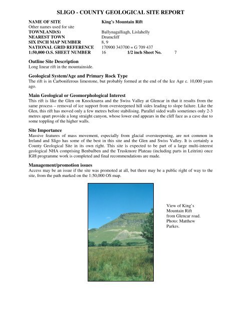
SLIGO - COUNTY GEOLOGICAL SITE REPORTNAME OF SITEKing’s Mountain RiftOther names used for <strong>site</strong>TOWNLAND(S)Ballynagalliagh, LislahellyNEAREST TOWNDrumcliffSIX INCH MAP NUMBER 8, 9NATIONAL GRID REFERENCE 170900 343700 = G 709 4371:50,000 O.S. SHEET NUMBER 16 1/2 inch Sheet No. 7Outline Site DescriptionLong linear rift in the mountainside.<strong>Geological</strong> System/Age and Primary Rock TypeThe rift is in Carboniferous limestone, but probably formed at the end <strong>of</strong> the Ice Age c. 10,000 yearsago.Main <strong>Geological</strong> or Geomorphological InterestThis rift is like the Glen on Knocknarea and the Swiss Valley at Glencar in that it results from thesame process – removal <strong>of</strong> ice support from oversteepened hill sides leading to slope failure. Like theGlen, this rift has moved only a few metres before stabilising. Parallel sided walls sometimes only 2-3metres apart provide a long straight canyon, whose lower end appears in the cliff face as a cave due tosome toppling <strong>of</strong> the higher walls.Site ImportanceMassive features <strong>of</strong> mass movement, especially from glacial oversteepening, are not common in<strong>Ireland</strong> and Sligo has some <strong>of</strong> the best in this <strong>site</strong> and the Glen and Swiss Valley. It is certainly aCounty <strong>Geological</strong> Site in its own right. This <strong>site</strong> is expected to be part <strong>of</strong> a large multi-interest<strong>geological</strong> NHA comprising Benbulben and the Truskmore Plateau (including parts in Leitrim) onceIGH programme work is completed and final recommendations are made.Management/promotion issuesAccess may be an issue if the <strong>site</strong> was promoted at all, but there may be a public right <strong>of</strong> way to the<strong>site</strong>, from the path marked on the 1:50,000 OS map.View <strong>of</strong> King’sMountain Riftfrom Glencar road.Photo: MatthewParkes.


