

sligo - county geological site report - Geological Survey of Ireland
sligo - county geological site report - Geological Survey of Ireland
sligo - county geological site report - Geological Survey of Ireland
- No tags were found...

You also want an ePaper? Increase the reach of your titles
YUMPU automatically turns print PDFs into web optimized ePapers that Google loves.
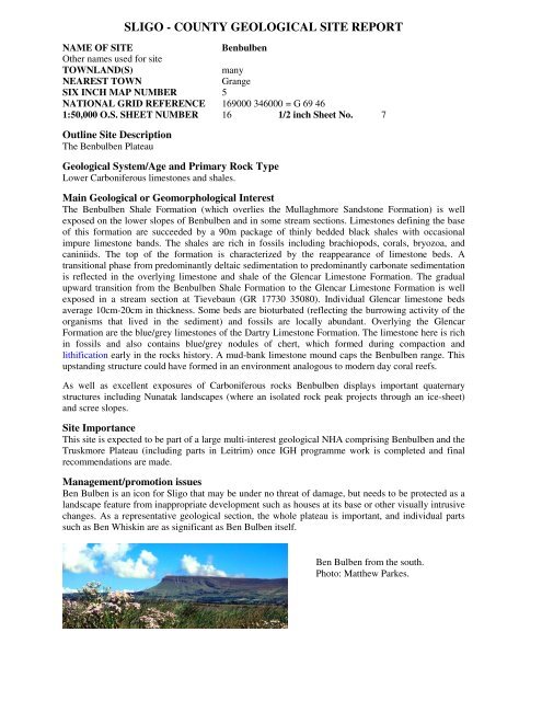
SLIGO - COUNTY GEOLOGICAL SITE REPORTNAME OF SITEBenbulbenOther names used for <strong>site</strong>TOWNLAND(S)manyNEAREST TOWNGrangeSIX INCH MAP NUMBER 5NATIONAL GRID REFERENCE 169000 346000 = G 69 461:50,000 O.S. SHEET NUMBER 16 1/2 inch Sheet No. 7Outline Site DescriptionThe Benbulben Plateau<strong>Geological</strong> System/Age and Primary Rock TypeLower Carboniferous limestones and shales.Main <strong>Geological</strong> or Geomorphological InterestThe Benbulben Shale Formation (which overlies the Mullaghmore Sandstone Formation) is wellexposed on the lower slopes <strong>of</strong> Benbulben and in some stream sections. Limestones defining the base<strong>of</strong> this formation are succeeded by a 90m package <strong>of</strong> thinly bedded black shales with occasionalimpure limestone bands. The shales are rich in fossils including brachiopods, corals, bryozoa, andcaniniids. The top <strong>of</strong> the formation is characterized by the reappearance <strong>of</strong> limestone beds. Atransitional phase from predominantly deltaic sedimentation to predominantly carbonate sedimentationis reflected in the overlying limestone and shale <strong>of</strong> the Glencar Limestone Formation. The gradualupward transition from the Benbulben Shale Formation to the Glencar Limestone Formation is wellexposed in a stream section at Tievebaun (GR 17730 35080). Individual Glencar limestone bedsaverage 10cm-20cm in thickness. Some beds are bioturbated (reflecting the burrowing activity <strong>of</strong> theorganisms that lived in the sediment) and fossils are locally abundant. Overlying the GlencarFormation are the blue/grey limestones <strong>of</strong> the Dartry Limestone Formation. The limestone here is richin fossils and also contains blue/grey nodules <strong>of</strong> chert, which formed during compaction andlithification early in the rocks history. A mud-bank limestone mound caps the Benbulben range. Thisupstanding structure could have formed in an environment analogous to modern day coral reefs.As well as excellent exposures <strong>of</strong> Carboniferous rocks Benbulben displays important quaternarystructures including Nunatak landscapes (where an isolated rock peak projects through an ice-sheet)and scree slopes.Site ImportanceThis <strong>site</strong> is expected to be part <strong>of</strong> a large multi-interest <strong>geological</strong> NHA comprising Benbulben and theTruskmore Plateau (including parts in Leitrim) once IGH programme work is completed and finalrecommendations are made.Management/promotion issuesBen Bulben is an icon for Sligo that may be under no threat <strong>of</strong> damage, but needs to be protected as alandscape feature from inappropriate development such as houses at its base or other visually intrusivechanges. As a representative <strong>geological</strong> section, the whole plateau is important, and individual partssuch as Ben Whiskin are as significant as Ben Bulben itself.Ben Bulben from the south.Photo: Matthew Parkes.
Benbulben
SLIGO - COUNTY GEOLOGICAL SITE REPORTNAME OF SITETruskmoreOther names used for <strong>site</strong>TOWNLAND(S)MoodogeNEAREST TOWNCliffonySIX INCH MAP NUMBER 6NATIONAL GRID REFERENCE 176000 347400 = G 76 4741:50,000 O.S. SHEET NUMBER 16 1/2 inch Sheet No. 7Outline Site DescriptionExposures <strong>of</strong> rock weathering features adjacent to summit <strong>of</strong> Truskmore.<strong>Geological</strong> System/Age and Primary Rock TypeRemnant periglacial features which formed during the later stages <strong>of</strong> the last glaciation (theMidlandian Glaciation) approximately 10,000 years ago.Main <strong>Geological</strong> or Geomorphological InterestA thin layer <strong>of</strong> horizontally bedded, lower Carboniferous Glenade Sandstone caps the summit <strong>of</strong>Truskmore producing a flat plateau area above the less resistant Meenymore evaporites and DartryLimestone. Remnant periglacial features flank the sandstone plateau including sorted nets, stonebanked terraces, stone stripes and a bedrock terrace with associated debris fan. Sorted nets displaying afish-net-tights-pattern are exposed close to the summit <strong>of</strong> Truskmore. The nets occur as vegetatedcentres with stone borders and exhibit varying diameter sizes from approximately 1m-5m. Theyprobably formed due to frost sorting and heave. The stone borders, consisting <strong>of</strong> Glenade sandstoneclasts ranging in size from pebble to boulder, are quite angular indicating that they have not travelledfar from their source. The northeastern side <strong>of</strong> the plateau hosts a 120m long bedrock terrace that hasbeen cut into the Glenade sandstone as a result <strong>of</strong> frost shattering. A large debris fan associated withthe terrace covers the slope below. Mass movement <strong>of</strong> weathered Glenade sandstone has producedstone stripes (up to 4m wide and 100m long) and stone banked terraces on the southeastern side <strong>of</strong>Truskmore. These features formed as seasonally thawed material moved slowly downslope under theinfluence <strong>of</strong> gravity. It is believed that the summit <strong>of</strong> Truskmore remained ice-free during the lastglaciation allowing for the many freeze-thaw cycles required to shatter and move the local bedrock.Site ImportanceThis <strong>site</strong> is expected to be part <strong>of</strong> a large multi-interest <strong>geological</strong> NHA comprising Benbulben and theTruskmore Plateau (including parts in Leitrim) once IGH programme work is completed and finalrecommendations are made.Management/promotion issuesAny disturbance will damage the scientific value <strong>of</strong> the patterned ground, including roads ortrackways, windfarm development, use <strong>of</strong> <strong>of</strong>f-road vehicles over these features.
SLIGO - COUNTY GEOLOGICAL SITE REPORTNAME OF SITEKing’s Mountain RiftOther names used for <strong>site</strong>TOWNLAND(S)Ballynagalliagh, LislahellyNEAREST TOWNDrumcliffSIX INCH MAP NUMBER 8, 9NATIONAL GRID REFERENCE 170900 343700 = G 709 4371:50,000 O.S. SHEET NUMBER 16 1/2 inch Sheet No. 7Outline Site DescriptionLong linear rift in the mountainside.<strong>Geological</strong> System/Age and Primary Rock TypeThe rift is in Carboniferous limestone, but probably formed at the end <strong>of</strong> the Ice Age c. 10,000 yearsago.Main <strong>Geological</strong> or Geomorphological InterestThis rift is like the Glen on Knocknarea and the Swiss Valley at Glencar in that it results from thesame process – removal <strong>of</strong> ice support from oversteepened hill sides leading to slope failure. Like theGlen, this rift has moved only a few metres before stabilising. Parallel sided walls sometimes only 2-3metres apart provide a long straight canyon, whose lower end appears in the cliff face as a cave due tosome toppling <strong>of</strong> the higher walls.Site ImportanceMassive features <strong>of</strong> mass movement, especially from glacial oversteepening, are not common in<strong>Ireland</strong> and Sligo has some <strong>of</strong> the best in this <strong>site</strong> and the Glen and Swiss Valley. It is certainly aCounty <strong>Geological</strong> Site in its own right. This <strong>site</strong> is expected to be part <strong>of</strong> a large multi-interest<strong>geological</strong> NHA comprising Benbulben and the Truskmore Plateau (including parts in Leitrim) onceIGH programme work is completed and final recommendations are made.Management/promotion issuesAccess may be an issue if the <strong>site</strong> was promoted at all, but there may be a public right <strong>of</strong> way to the<strong>site</strong>, from the path marked on the 1:50,000 OS map.View <strong>of</strong> King’sMountain Riftfrom Glencar road.Photo: MatthewParkes.
King’s Mountain Rift
SLIGO - COUNTY GEOLOGICAL SITE REPORTNAME OF SITESwiss ValleyOther names used for <strong>site</strong>GlencarTOWNLAND(S)TormoreNEAREST TOWNDrumcliffSIX INCH MAP NUMBER 9NATIONAL GRID REFERENCE 174000 344000 = G 74 441:50,000 O.S. SHEET NUMBER 16 1/2 inch Sheet No. 7Outline Site DescriptionMass movement landscapes.<strong>Geological</strong> System/Age and Primary Rock Type10,000-year-old ice-sculpted valley side with landslips.Main <strong>Geological</strong> or Geomorphological InterestThe Swiss Valley is situated at the base <strong>of</strong> the Dartry limestone cliffs <strong>of</strong> Glencar. Towards the end <strong>of</strong>the last glaciation (approximately 10,000 years ago) as the ice grew thinner, ice flow was channelledaround higher mountains accentuating glaciated valleys such as that at Glencar. As the ice meltedlarge-scale landslips occurred where unstable, oversteepened valley walls lost the support <strong>of</strong> the iceand slid downwards in enormous slices on spoon shaped fractures. These landslips now take the form<strong>of</strong> huge steps ascending the valley walls.Site ImportanceThis <strong>site</strong> is expected to be part <strong>of</strong> a large multi-interest <strong>geological</strong> NHA comprising Benbulben and theTruskmore Plateau (including parts in Leitrim) once IGH programme work is completed and finalrecommendations are made.Management/promotion issuesNew house building could detract from the integrity <strong>of</strong> these features if permitted. They could bepromoted as interesting landscape features if access is not problematicTwo landslippedblocks visiblelooking west fromthe plateau edgeon the Leitrim side<strong>of</strong> the borderwhere the SwissValley boreenreaches the plateauedge.
Swiss Valley
Glencarbury Barite Mine


