

Tallow GWB - Geological Survey of Ireland
Tallow GWB - Geological Survey of Ireland
Tallow GWB - Geological Survey of Ireland

You also want an ePaper? Increase the reach of your titles
YUMPU automatically turns print PDFs into web optimized ePapers that Google loves.
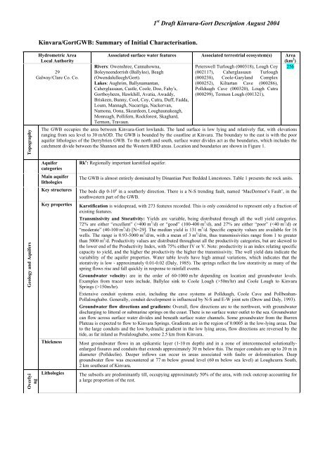
1 st Draft Kinvara-Gort Description August 2004Kinvara/Gort<strong>GWB</strong>: Summary <strong>of</strong> Initial Characterisation.TopographyHydrometric AreaLocal Authority29Galway/Clare Co. Co.Associated surface water features Associated terrestrial ecosystem(s) Area(km 2 )Rivers: Owenshree, Cannahowna,Peterswell Turlough (000318), Lough Coy 256Boleyneendorrish (Ballylee), Beagh(002117), Caherglassaun Turlough(Owendalulleegh/Gort).(000238), Coole-Garyland ComplexLakes: Aughrim, Ballynamantan,(000252), Kiltartan Cave (000286),Caherglassaun, Castle, Coole, Doo, Fahy's, Pollduagh Cave (000320), Lough CutraGortboyheen, Hawkhill, Avatia, Awaddy, (000299), Termon Lough (001321),Briskeen, Bunny, Cool, Coy, Cutra, Duff, Fadda,Loum, Mannagh, Nacarriga, Nackervan,Namona, Oona, Skeardeen, Loughaunakeagh,Monreagh, Pollifern, Rockforest, Skaghard,Termon, Travaun.The <strong>GWB</strong> occupies the area between Kinvara-Gort lowlands. The land surface is low lying and relatively flat, with elevationsranging from sea level to 30 mAOD. The <strong>GWB</strong> is bounded by the coastline at Kinvara. The boundary to the east is with the pooraquifer lithologies <strong>of</strong> the Derrybrien <strong>GWB</strong>. To the north and south, surface water divides act as the boundaries, which includes thecatchment divide between the Shannon and the Western RBD areas. Location and boundaries are shown in Figure 1.Geology and AquifersOverlyingAquifercategoriesMain aquiferlithologiesKey structuresKey propertiesThicknessLithologiesRk c : Regionally important karstified aquifer.The <strong>GWB</strong> is almost entirely dominated by Dinantian Pure Bedded Limestones. Table 1 presents the rock units.The beds dip 0-10 o in a southerly direction. There is a N-S trending fault, named ‘MacDermot’s Fault’, in thesouthwestern part <strong>of</strong> the <strong>GWB</strong>.Karstification is widespread, with 273 features recorded. This is only considered to represent only a fraction <strong>of</strong>existing features.Transmissivity and Storativity: Yields are variable, being distributed through all the well yield categories.72% are either “excellent” (>400 m 3 /d) or “good” (100-400 m 3 /d), and 27% are either “poor” (50m/hr) and Coole Lough to KinvaraSprings (>150m/hr).Extensive conduit systems exist, including the cave systems at Pollduagh, Coole Cave and Pollbeahan-Pollaloughabo. Generally, conduit development is influenced by N-S and E-W joint sets (Drew and Daly, 1993).Groundwater flow directions and gradients: Overall, flow directions are to the northwest, with groundwaterdischarging to littoral or submarine springs on the coast. There is no surface water outlet to the sea. Groundwatercan flow across surface water divides and beneath surface water channels. Some groundwater from the BurrenPlateau is expected to flow to Kinvara Springs. Gradients are in the region <strong>of</strong> 0.0005 in the low-lying areas. Dueto the large conduits and the low hydraulic gradient in the low lying areas, flow directions are reversed by thetide, as far inland as Poulaloughabo, some 2.5 km from Kinvara.Most groundwater flows in an epikarstic layer (1-10 m depth) and in a zone <strong>of</strong> interconnected solutionallyenlargedfissures and conduits that extends approximately 30 m below this. The major conduits are up to 20 m indiameter (Polldeelin). Deeper inflows can occur in areas associated with faults or dolomitisation. Deepgroundwater flow was encountered at 77 m below ground level (60 m below sea level) at Loughcurra South,2 km southeast <strong>of</strong> Kinvara.The subsoils are predominantly till, occupying approximately 50% <strong>of</strong> the area, with rock outcrop accounting fora large proportion <strong>of</strong> the rest.
1 st Draft Kinvara-Gort Description August 2004RechargeDischargeThickness% area aquifernear surfaceVulnerabilityMain rechargemechanismsEst. rechargeratesLarge springsand highyielding wells(m 3 /d)Main dischargemechanismsHydrochemicalSignatureGroundwater FlowPathsThe thickness is generally less than 3 m (N=41). However, there are areas <strong>of</strong> greater depths, for example, to theeast <strong>of</strong> Ardrahan, in the northeasternmost corner <strong>of</strong> the <strong>GWB</strong>, the thickness varies from 0-6 m, with 2 instances<strong>of</strong> greater than 10 m.[Information to be added at a later date][Information to be added at a later date]Both point and diffuse recharge occur. Diffuse recharge occurs via rainfall percolating through the permeablesubsoil and rock outcrops. Point recharge occurs by means <strong>of</strong> swallow holes, collapse features/dolines, andwhere flow is concentrated in the epikarst. Streams flowing <strong>of</strong>f the non-limestone rocks sink on meeting thelimestone, thus the majority <strong>of</strong> the swallow holes are located near the inland boundaries <strong>of</strong> the <strong>GWB</strong>. Rechargealso occurs along ‘losing’ sections <strong>of</strong> streams, for example along a well defined 2 km stretch <strong>of</strong> the OwenshreeRiver (Daly, 1985; Drew and Daly, 1993).[Information to be added at a later date]Excellent wells : Loughcurra South – 1,400 m 3 /d (2).Springs: Kinvara 40,000 m 3 /d.Kinvara Springs are the main outlet for the entire Kinvara-Gort Lowlands and the western uplands <strong>of</strong> SlieveAughty. Three main rivers drain the Slieve Aughty uplands (Owenshree, Boleyneendorrish and Beagh). Onreaching the limestone they tend to flow to the southwest for a short distance before sinking. Most <strong>of</strong> thegroundwater that sinks focuses on the Coole Lough area, and from there water flows entirely underground in anorthwesterly direction, via a single major conduit system, up to 25 m in diameter, discharging to a group <strong>of</strong>large springs located in the intertidal zone at Kinvara, some 10-15 km distant (Drew, 2001; Drew and Daly,1993). Flooding is a serious issue in the area. There is no surface outlet to Galway Bay and the dimensions <strong>of</strong> themajor conduits are fixed therefore there is a limit to what the underground system can take. Thus, during periods<strong>of</strong> heavy rainfall, the water backs up and floods the area upstream <strong>of</strong> the swallow holes (Drew and Daly, 1993).There is some degree <strong>of</strong> flooding each year.The groundwater has a calcium bicarbonate signature which is illustrated using an expanded Durov plot,presented in Figure 2. The springs at Kinvara have a daily variability in chemistry, as saline conditions survivefor up to 4 hours after high tide, for example, Naughton (1975) describes how chloride levels decrease fromapproximately 3,500 mg/l to 50 mg/l as the tide drops. Brackish water occurs up to 5 kilometers inland due tothe large conduits and the low hydraulic gradient. The range and median values for selected parameters forKinvara and Roo (Gort) are given below.Kinvara (N=14) Roo (Gort) (N=6)Alkalinity (mg/lCaCO3) 140-228, 186 264-324, 314Hardness (mg/lCaCO3) 168-372, 226 332-348, 344Conductivity (microsiemens/cm) 262-574, 460 676-691, 687These rocks are generally devoid <strong>of</strong> intergranular permeability. Groundwater flows through conduits, fissures,faults, joints and bedding planes. In pure bedded limestones these openings are enlarged by karstification whichsignificantly enhances the permeability <strong>of</strong> the rock. Karstification can be accentuated along structural featuressuch as fold axes and faults. Groundwater flow through karst areas is extremely complex and difficult to predict.As flow pathways are <strong>of</strong>ten determined by discrete conduits, actual flow directions will not necessarily beperpendicular to the assumed water table contours, as shown by several tracing studies (Drew and Daly, 1993).The tracer tests show that groundwater can flow across surface water catchment divides and beneath surfacewater channels. A proportion <strong>of</strong> the groundwater from the eastern side <strong>of</strong> the Ballyvaughan area is considered t<strong>of</strong>low to Kinvara. Flow velocities can be rapid and variable, both spatially and temporally. Rapid groundwaterflow velocities indicate that a large proportion <strong>of</strong> groundwater flow occurs in enlarged conduit systems.Groundwater flow in highly permeable karstified limestones is <strong>of</strong> a regional scale. Flow path lengths are up toten kilometres. Overall, groundwater flow will be towards sea, but the highly karstified nature <strong>of</strong> the bedrockmeans that locally groundwater flow directions can be highly variable.Groundwater flow is trimodal:(1) flow via the epikarst (1-10m depth).(2) flow via solutionally enlarged conduits and cave systems, up to 40 m below ground.(3) flow via smaller fractures and joints linked to the main conduit systems.From Caherglassaun Lough to the sea a single large conduit up to 25 m diameter carries all <strong>of</strong> the undergrounddrainage to Kinvara, though at high stage conditions water discharges to Corranroo, an ancient outlet fordischarge from this major conduit. (Drew, 2001). Figure 3 shows the groundwater flow directions in theKinvara-Gort lowlands.There is evidence for a deeper groundwater flow system. A borehole 2 km southeast <strong>of</strong> Kinvara encounteredwater at 60 m below sea level, the chemistry <strong>of</strong> which is distinct and is possible that it is derived from theeastern area <strong>of</strong> the Burren uplands (Drew and Daly, 1993).
1 st Draft Kinvara-Gort Description August 2004Conceptual modelGroundwater &Surface waterinteractionsThere is a high degree <strong>of</strong> interconnection between groundwater and surface water, particularly in the areabetween Caherglassaun Lough and the sinking rivers, where the drainage alternates from being on the surface tobeing underground. For example the Owendullagh/Beagh/Gort river sinks and re-appears six times over adistance <strong>of</strong> less than 10 kilometres. Coole Lough is a permanent water body but also functions as a swallowhole. Between Caherglassaun Lough and the sea there is virtually no surface drainage. There are encloseddepressions into the underground environment which extend along a NW/W trending line from CaherglassaunLough to Kinvara. This is illustrated in Figure 4. Collapse features in these areas provide a direct connectionbetween the surface and the groundwater systems. The close interaction between surface water and groundwaterin karstified aquifers is reflected in their closely linked water quality. Any contamination <strong>of</strong> surface water israpidly transported into the groundwater system, and vice versa. Furthermore, there are a number <strong>of</strong> terrestrialecosystems within this <strong>GWB</strong> with varying dependence on groundwater. The drainage system has not undergonethe same level <strong>of</strong> change from major arterial drainage works as found in the other major karst <strong>GWB</strong>’s, such asthe Clare-Corrib and the Cong-Robe <strong>GWB</strong>’s. Thus the hydrological system in place in the Kinvara-Gort areamay be representative <strong>of</strong> conditions that were more widespread throughout the karst systems <strong>of</strong> Clare-Corrib andthe Cong-Robe <strong>GWB</strong>’s (Drew and Daly, 1993).• The <strong>GWB</strong> occupies the area between Gort, Kinvara, and Ardrahan. It is bounded by the coastline along Kinvara. Theeastern boundary is with the poor aquifer lithologies <strong>of</strong> the Derrybrien <strong>GWB</strong>. The northern and southern boundaries aresurface water divides.• A large number <strong>of</strong> karst features occur, including turloughs, caves, dolines, swallow holes and springs.• The <strong>GWB</strong> is composed primarily <strong>of</strong> high transmissivity karstified limestone (Rk c ). Transmissivity and well yields arevariable. Storativity is low. Gradients are typically 0.0005 in the low lying areas.• Groundwater flow is trimodal:(1) flow via the epikarst (1-10m depth).(2) flow via solutionally enlarged conduits and cave systems, up to 40 m below ground.(3) flow via smaller fractures and joints linked to the main conduit systems.• Rapid groundwater flow velocities have been recorded through groundwater tracing.• Recharge occurs via losing streams, point and diffuse mechanisms.• In general, the degree <strong>of</strong> interconnection in karstic systems is high and they support regional scale flow systems. Flowpaths are up to 10 kilometres in length.• Surface water catchments are <strong>of</strong>ten bypassed by groundwater flowing beneath surface water channels and across surfacewater catchment divides. A proportion <strong>of</strong> groundwater from the Burren Uplands is considered to discharge to Kinvara.• Some areas are <strong>of</strong> extreme vulnerability due to the thin nature <strong>of</strong> the subsoil, as well as the frequency <strong>of</strong> karst features,allowing point recharge. Storativity is low and the potential for contaminant attenuation in such aquifers is limited.• Kinvara Springs are the main outlet for the entire Kinvara-Gort Lowlands and the western uplands <strong>of</strong> Slieve Aughty.Rivers draining the Slieve Aughty uplands sink on reaching the limestone. Most <strong>of</strong> the groundwater that sinks focuses onthe Coole Lough area, and from there water flows entirely underground in a northwesterly direction via a major cavesystem, discharging to a group <strong>of</strong> large springs located in the intertidal zone at Kinvara.• There is a high degree <strong>of</strong> interaction between surface water and groundwater. In the eastern area water frequently sinksand rises before being transmitted underground mostly to Kinvara.• The groundwater has a calcium bicarbonate signature. The water is saline up to several kilometers inland.Attachments Table 1 and Figure 1, 2, 3, 4.InstrumentationInformationSourcesDisclaimerStream gauges:EPA Water Level Monitoring boreholes: (GAL 283)EPA Representative Monitoring points: (GAL 062), (GAL 293).Daly, D. (1995) A report on the Flooding in the Glenamaddy area. Groundwater Section Report File 2.2.7. 34pp.Daly, D. (1985) Groundwater in County Galway with particular reference to its Protection from Pollution. <strong>Geological</strong><strong>Survey</strong> <strong>of</strong> <strong>Ireland</strong> report for Galway County Council. 98pp.Deakin, J., Daly D. (2000) County Clare Groundwater Protection Scheme. Main Report. Clare County Council &<strong>Geological</strong> <strong>Survey</strong> <strong>of</strong> <strong>Ireland</strong>.Drew, D. (2001) The Burren and the Gort-Kinvara Lowland, Groundwater Flow Systems in Karstified Limestones.Irish Group. Karst Field Trip October 2001. Unpublished IAH Report.Drew D.P. and Daly D. (1993) Groundwater and Karstification in Mid-Galway, South Mayo and North Clare. A JointReport: Department <strong>of</strong> Geography, Trinity College Dublin and Groundwater Section, <strong>Geological</strong> <strong>Survey</strong> <strong>of</strong> <strong>Ireland</strong>.<strong>Geological</strong> <strong>Survey</strong> <strong>of</strong> <strong>Ireland</strong> Report Series 93/3 (Groundwater), 86 ppHickey, C., Lee, M., Drew, D., Meehan, R. and Daly D. (2002) Lowland Karst <strong>of</strong> North Roscommon and Westmeath.International Association <strong>of</strong> Hydrogeologists Irish Group. Karst Field Trip October 2002. Unpublished IAH Report.Naughton, M. (1975) Groundwater and related features in a temperate limestone area. B.A. (Mod) Dissertation,(unpublished). Geography Department, Trinity College Dublin.Note that all calculation and interpretations presented in this report represent estimations based on the informationsources described above and established hydrogeological formulae.
1 st Draft Kinvara-Gort Description August 2004Table 1. List <strong>of</strong> Rock unitsRock unit name and code Description Rock unit groupAquiferClassificationAillwee member (lower) (BUal) bedded & massive fossiliferous limestone Dinantian Pure Bedded Limestones RkcBalliny Member (SLbi) cyclical crinoidal limestone Dinantian Pure Bedded Limestones RkcBallyelly Member (SLbe) nodular & crinoidal limestone with chert Dinantian Pure Bedded Limestones RkcBlack Head Member (BUbh) limestone & dolomite with corals Dinantian Pure Bedded Limestones RkcCastlequarter Member (TUcq) monotonous limestone and dolomite Dinantian Pure Bedded Limestones RkcCoranellistrum Formation (CT) Medium to thick-bedded pure limestone Dinantian Pure Bedded Limestones RkcFahee North Member (SLfh) fossiliferous limestone with chert Dinantian Pure Bedded Limestones RkcFanore Member (BUfn) dolomitised limestone with shale Dinantian Pure Bedded Limestones RkcFinavarra Member (TUfv) bioturbated limestone with dolomite Dinantian Pure Bedded Limestones RkcHawkhill Member (BUhh) peloidal limestone with chert Dinantian Pure Bedded Limestones RkcMaumcaha Member (BUmc) massive limestone sparsely fossiliferous Dinantian Pure Bedded Limestones RkcNewtown Member (TUnt) cherty limestone Dinantian Pure Bedded Limestones RkcTubber Formation (TU) Crinoidal & cherty limestone & dolomite Dinantian Pure Bedded Limestones RkcFigure 1 Location and Boundaries <strong>of</strong> <strong>GWB</strong>Figure 2Chemical Signature <strong>of</strong> Relatively Uncontaminated Waters (expanded Durov Plot)75Samples withbicarbonate/nitrate signatureSamples with calcium signature Samples with magnesium signature Samples with sodium/potassium signatureSignature Boundarieskinvaragortballyvaughanbellharbour5025Samples withchloride signatureSamples withsulphate signature00 25 50 75
1 st Draft Kinvara-Gort Description August 2004Figure 3 Groundwater flow systems in Gort-Kinvara Lowlands (after Drew, 2001)Figure 4 Hydrology <strong>of</strong> the Gort-Kinvara area (after Drew, 2001)


