Draft Helmsley Plan (June 2013) - North York Moors National Park
Draft Helmsley Plan (June 2013) - North York Moors National Park
Draft Helmsley Plan (June 2013) - North York Moors National Park

You also want an ePaper? Increase the reach of your titles
YUMPU automatically turns print PDFs into web optimized ePapers that Google loves.
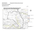
IntroductionThe <strong>Helmsley</strong> <strong>Plan</strong> will comprise part of the statutory planning decision framework ofboth Ryedale District Council and the <strong>North</strong> <strong>York</strong> <strong>Moors</strong> <strong>National</strong> <strong>Park</strong> Authority. As aLocal <strong>Plan</strong> it will be used as the basis for decisions on planning matters which takeplace in <strong>Helmsley</strong>. It has been jointly produced as the boundary of the <strong>North</strong> <strong>York</strong><strong>Moors</strong> <strong>National</strong> <strong>Park</strong> runs through the middle of the town. Approximately half of thetown lies within the <strong>National</strong> <strong>Park</strong> which means it has the highest status of protectionin relation to landscape and scenic beauty with statutory purposes to conserve andenhance the natural beauty and promote understanding of the <strong>North</strong> <strong>York</strong> <strong>Moors</strong>.However the two authorities recognise that as an important local service centre forthe wider rural hinterland, it is important that development in <strong>Helmsley</strong> is carefully,proactively and jointly planned.The plan includes:-A Vision for <strong>Helmsley</strong>An overview of how the <strong>Helmsley</strong> <strong>Plan</strong> fits in with <strong>National</strong> <strong>Plan</strong>ning Policyincluding <strong>National</strong> <strong>Park</strong> designationWhere future development will take place and what this should look likeThe allocation of sites in the <strong>Helmsley</strong> <strong>Plan</strong> provides certainty to developers, localpeople and infrastructure providers as to what development is likely to happen in thetown. It will also ensure that the town has sufficient housing and employment land tomeet its economic growth and increased population.Decisions on other elements of planning such as residential extensions will continueto be considered against the policies contained in the relevant development plan forRyedale District Council or the <strong>National</strong> <strong>Park</strong> Authority depending on the location ofthe property.A Description Of <strong>Helmsley</strong><strong>Helmsley</strong> is a small market town situated on the southern boundary of the <strong>North</strong> <strong>York</strong><strong>Moors</strong> <strong>National</strong> <strong>Park</strong> nestling in a hollow 24 miles away from <strong>York</strong> and 32 miles fromScarborough. The town sits at the junction of the A170, which runs from Pickering toThirsk, and the B1257 road, which runs south over the moors from Stokesley. Thearea to the north of the A170 and west of the Market Place are located within the<strong>North</strong> <strong>York</strong> <strong>Moors</strong> <strong>National</strong> <strong>Park</strong>. Entry into the town from the south is over the late18th century Scheduled bridge which crosses the river Rye forming a natural barrierto the south of the town. The town is flanked by heather moor to the north, risingwooded land to the west and rolling farmland to the South.<strong>Helmsley</strong> lies within the <strong>North</strong> <strong>York</strong> <strong>Moors</strong> and Cleveland Hills <strong>National</strong> CharacterArea but is bounded to the south by the Vale of Pickering <strong>National</strong> Character Areaand therefore is probably transitional between the two. In the <strong>North</strong> <strong>York</strong>shireLandscape Character Assessment the site falls within the classification of LimestoneFoothills and Valleys. Within this assessment the landscape is noted as being of highvisual sensitivity as a result of its panoramic views across the Vale of Pickering andstrong intervisibility with adjacent landscapesThe town was first settled in around 3000 BC and by the time it was mentioned in theDomesday Book had become a modest village with the distinctive features whichmake up today’s street plan. <strong>Helmsley</strong> Castle was constructed around the 12 thCentury in order to control the river crossing.5