WB3: Risk Management
WB3: Risk Management
WB3: Risk Management
- No tags were found...

Create successful ePaper yourself
Turn your PDF publications into a flip-book with our unique Google optimized e-Paper software.
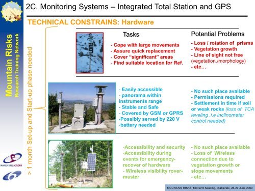
2C. Monitoring Systems – Integrated Total Station and GPSMountain <strong>Risk</strong>sResearch Training NetworkTECHNICAL CONSTRAINS: Hardware> 1 month Set-up and Start-up phase neededTasks- Cope with large movements- Assure quick replacement- Cover “significant” areas- Find suitable location for Ref.- Easily accessible- panorama withininstruments range- Stable and Safe- Covered by GSM or GPRS-Possibly served by 220 V-battery needed-Accessibility and security-Accessibility duringevents for emergencyrecoverof hardware- Wireless visibility rovermasterPotential Problems- Loss / rotation of prisms- Vegetation growth- Line of sight not free(vegetation./morphology)- etc…- No such place available- Permissions required- Settlement in time if soilor weak rocks (loss of TCAleveling .i.e inclinometercontrol needed)- No such place available- Loss of Wirelessconnection due tovegetation growth orslope movements- etc…MOUNTAIN RISKS: Mid-term Meeting, Diablerets, 26-27 June 2009