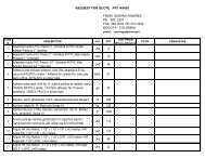
W913FT-11-R-0020MIDNIGHT EXPRESS NAVIGATION EQUIPMENTPRICING SPREADSHEET<strong>ITEM</strong> <strong>DESCRIPTION</strong> <strong>QTY</strong> <strong>UNIT</strong> <strong>PRICE</strong> <strong>TOTAL</strong> <strong>PRICE</strong>Electronic Bearing Lines: 2 x EBL’s, floating if required,resolution 1°, Bearing Scale: 360° graduated at 10° intervals 2°small ticks 10° large ticks, Minimum Range: 23m (25 yds), RangeDiscrimination: 23m (25 yds), Presentation Modes: Head up,Course up or North up (selectable True or Mag-netic) Relative orTrue Motion, Scanner Control: Interference rejection,standby/transmit modes, pulse selection, Tune, Rain, FTC and Seacontrols, with selection of manual or automatic control of gain, seaclutter and tune (Auto GST), Compass Input: NMEA 0183(required for fast heading data, suitable for MARPA), or SeaTalk,Waypoint Display: Create waypoints and target waypoint displayedwith User control of symbols and groups, MARPA: Manualacquisition of up to 25 targets (dependent upon scanner type),automatic tracking, dangerous target alarms, safe zone, targethistory, true or relative vectors, CPA graphics and indication oftarget speed/ course, bearing/ range, CPA and TCPA, Guard ZoneAlarm: 2 guard zones, selectable sensitivity level, audible alarm,Automatic Tuning: Auto control of gain, sea clutter and tune, OffCenter Function: In Relative Motion, 1/3 or 2/3, Wakes: 10s, 30s,1 min, 5 min & 10 min options, Target Expansion: Operatorselectable with 2 levels available, Timed TX: Rotation periods: 10,Instrument and Engine Data: Data Pages: 5 pages pg available. Pre-defined (Navigation, Waypoint, Route, Fishing or Sailing) or userconfigured,Data Available: Vessel position, active waypoint,TTG, VMG - Waypoint, depth, COG, SOG, heading, speed,set/drift, trip, log, ground log, ground trip, rudder, local time anddate, sea temperature, app wind, true wind, VMG wind, groundwind XTE, compass, locked heading, Engine Pages: 5 pagesavailable, Pre-defined (engine, engine and fuel, fuel resources,engine and resources, twin engines or triple engine support) or userconfigured,Engine Data: Tacho, boost pressure, alternator, oilpressure, coolant temperature, engine hours, fuel level (tanks 1 &2), fuel rate, total fuel, load.AIS: AIS Support: For class B AIS, Supports silent mode, TargetSymbols: Sleeping, activated, selected, dangerous and lost, TargetInformation: AIS vectors, buddy tracking, safety critical data andfull AIS data, Collision Avoidance: Safe zones and safetymessages, Alarms: Local alarm messages, lost targets.NAVTEX: Alerts: Incoming messageMessage List: Sorting.(selectable categories),Page 4
W913FT-11-R-0020MIDNIGHT EXPRESS NAVIGATION EQUIPMENTPRICING SPREADSHEET<strong>ITEM</strong> <strong>DESCRIPTION</strong> <strong>QTY</strong> <strong>UNIT</strong> <strong>PRICE</strong> <strong>TOTAL</strong> <strong>PRICE</strong>Weather: Type: SIRIUS Marine Weather, Weather Elements:Storm cast, waves, Canadian radar, lightning, wind, sea surfacetemperature, observations stations, city weather, NOWRad, stormtracks, surface pressure, Animated Weather Graphics: Weatherforecast, weather radar history, Weather Reports: Tropicalstatements, marine warnings, marine zone forecasts, marinematchbox.General: Storage Temperature: -4°F to 149°F (-20°C to +65°C)ambient air at 95% RH.3 Seaflir III – Flir or Equivalent26 EAThermal Imager: Sensor type: 320 x 240 InSb focal plane array(640x480 option), Wavelength: 3-5 μm response, FOVs: 21.7° to1.2° (w/1.8x optical extender) Zoom range: 25 mm to 450 mm(w/1.8x optical extender).Color CCD-TV Camera: Format: NTSC or PAL, Type: SuperHAD CCD, ¼” Format, FOVs: 48° to 1.2°, Sensitivity: 0.7 Lux @F1.4.Laser Payloads: Rangefinder Type Erbium-glass, 1.54 μm,Max.range 20 km +/-5 m, Classification Class 1 (eyesafe), (y Pointer:Wavelength 830 nm,Power 135 mW, Classification Class IIIb.Stabilized Gimbal Assembly (SGA): System type: 2-axisstabilization, Az. Coverage: 360° continuous, El. Coverage: 360°continuous, Slew Rate: 0° to 140°/sec.System Interfaces: Analog video: NTSC or PAL, Digital video:Yes, Control: Ergonomic Laptop or Hand-held, Data: RS-232, RS-422.Environmental: Standards: MIL-STD-810 & RTCA DO-160D,Operating temperature: -40°C to +55°C.Power Requirements: Voltage: 18-32 VDC.Dimensions & Weight: SGA Size: 9.0” x 13.8” (22.9 cm x 35.0cm), Weight: 32 lbs (14.5 kg).Other Options & Accessories: Target Geo-Location,Navigation/Radar/Moving Map/Searchlight Interfaces, Mounts,4Monitors, Recorders, Power Supplies, Training and InstallationSupport.GPS – Raytamarine or Equivalent24 EAPage 5