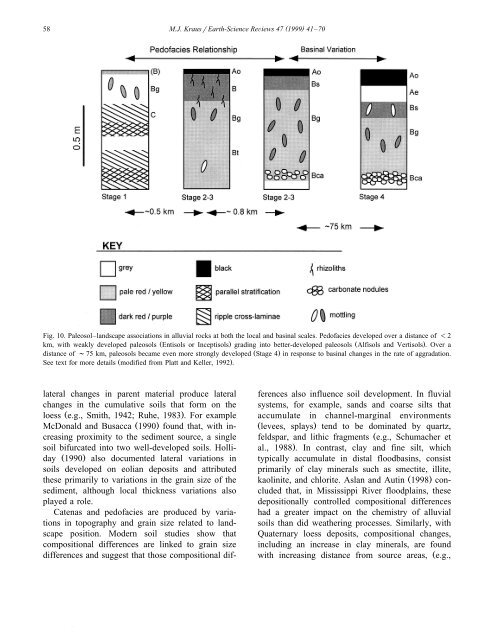
58( )M.J. KrausrEarth-Science ReÕiews 47 1999 41–70Fig. 10. Paleosol–landscape associations <strong>in</strong> alluvial <strong>rocks</strong> at both the local and bas<strong>in</strong>al scales. Pedofacies developed over a distance of -2km, with weakly developed paleosols Ž Entisols or Inceptisols. grad<strong>in</strong>g <strong>in</strong>to better-developed paleosols Ž Alfisols and Vertisols .. Over adistance of ;75 km, paleosols became even more strongly developed Ž Stage 4.<strong>in</strong> response to bas<strong>in</strong>al changes <strong>in</strong> the rate of aggradation.See text for more details Ž modified from Platt and Keller, 1992 ..lateral changes <strong>in</strong> parent material produce lateralchanges <strong>in</strong> the cumulative soils that form on theloess Ž e.g., Smith, 1942; Ruhe, 1983 .. For exampleMcDonald and Busacca Ž 1990.found that, with <strong>in</strong>creas<strong>in</strong>gproximity to the sediment source, a s<strong>in</strong>glesoil bifurcated <strong>in</strong>to two well-developed soils. HollidayŽ 1990.also documented lateral variations <strong>in</strong>soils developed on eolian deposits and attributedthese primarily to variations <strong>in</strong> the gra<strong>in</strong> size of thesediment, although local thickness variations alsoplayed a role.Catenas and pedofacies are produced by variations<strong>in</strong> topography and gra<strong>in</strong> size related to landscapeposition. Modern soil studies show thatcompositional differences are l<strong>in</strong>ked to gra<strong>in</strong> sizedifferences and suggest that those compositional differencesalso <strong>in</strong>fluence soil development. In fluvialsystems, for example, sands and coarse silts thataccumulate <strong>in</strong> channel-marg<strong>in</strong>al environmentsŽ levees, splays.tend to be dom<strong>in</strong>ated by quartz,feldspar, and lithic fragments Že.g., Schumacher etal., 1988 .. In contrast, clay and f<strong>in</strong>e silt, whichtypically accumulate <strong>in</strong> distal floodbas<strong>in</strong>s, consistprimarily of clay m<strong>in</strong>erals such as smectite, illite,kaol<strong>in</strong>ite, and chlorite. Aslan and Aut<strong>in</strong> Ž 1998.concludedthat, <strong>in</strong> Mississippi River floodpla<strong>in</strong>s, thesedepositionally controlled compositional differenceshad a greater impact on the chemistry of alluvialsoils than did weather<strong>in</strong>g processes. Similarly, withQuaternary loess deposits, compositional changes,<strong>in</strong>clud<strong>in</strong>g an <strong>in</strong>crease <strong>in</strong> clay m<strong>in</strong>erals, are foundwith <strong>in</strong>creas<strong>in</strong>g distance from source areas, Že.g.,
( )M.J. KrausrEarth-Science ReÕiews 47 1999 41–70 59.Smith, 1942; Kleiss and Fehrenbacher, 1973 . Thesestudies <strong>in</strong>dicate that compositional variations associatedwith different parts of the depositional landscapeshould also be considered when analyz<strong>in</strong>g and<strong>in</strong>terpret<strong>in</strong>g paleosols.4.2. Bas<strong>in</strong>al landscape reconstructionAt the bas<strong>in</strong> scale, analyz<strong>in</strong>g paleosolrlandscapeanalysis can provide <strong>in</strong>formation about global orregional climate change, sea level fluctuations, andregional tectonics. At a truly bas<strong>in</strong>al scale, AlonsoZarza et al. Ž 1992.described Miocene paleosols thatdeveloped <strong>in</strong> a spectrum of depositional sett<strong>in</strong>gs,<strong>in</strong>clud<strong>in</strong>g alluvial fans, lake marg<strong>in</strong>s, and river floodpla<strong>in</strong>s.Stratigraphic <strong>in</strong>tervals approximately 100 mthick were exam<strong>in</strong>ed <strong>in</strong> two contrast<strong>in</strong>g areas ofthe Madrid Bas<strong>in</strong>. <strong>Paleosols</strong> <strong>in</strong> the two areas differ,and those differences were related to local climaticconditions and sediment accumulation rates. Consequently,the authors could use the paleosols to<strong>in</strong>terpret bas<strong>in</strong>al variations <strong>in</strong> climate and bas<strong>in</strong> subsidence,which controlled sediment accumulationrates.In fluvial bas<strong>in</strong>s, changes <strong>in</strong> the k<strong>in</strong>ds of paleosolshave been documented <strong>in</strong> the direction of regionalpaleoslope. For example, <strong>in</strong> the Eocene Capella Formation,Atk<strong>in</strong>son Ž 1986.observed more mature andbetter-dra<strong>in</strong>ed paleosols proximal to the source area.Over a distance of nearly 30 km down paleoslope,progressively less mature and more poorly dra<strong>in</strong>edpaleosols were found. Atk<strong>in</strong>son attributed thesechanges to a decl<strong>in</strong>e <strong>in</strong> topographic relief and <strong>in</strong>creasedaccumulation rates away from the source.Over an even greater downslope distance Ž ;75 km .,Platt and Keller Ž 1992.also documented an <strong>in</strong>crease<strong>in</strong> the maturity and hydromorphy of floodpla<strong>in</strong> paleosolsŽ Fig. 10 .. Consistent with the <strong>in</strong>creased maturity,the stratigraphic <strong>in</strong>terval th<strong>in</strong>s downslope, <strong>in</strong>dicat<strong>in</strong>gslower sediment accumulation <strong>in</strong> more distalparts of the alluvial bas<strong>in</strong>.McCarthy et al. Ž 1997.recognized floodpla<strong>in</strong> paleosolsof vary<strong>in</strong>g degrees of pedogenic developmentand related the paleosols to landscape position on abas<strong>in</strong>al scale. In this Lower Cretaceous example, thepaleosols formed <strong>in</strong> a foreland bas<strong>in</strong> adjacent to theepicont<strong>in</strong>ental seaway that developed <strong>in</strong> North Americadur<strong>in</strong>g that time. Not surpris<strong>in</strong>gly, the authorsasserted that pedogenic development should be directlydependent on floodpla<strong>in</strong> stability and that thetectonic h<strong>in</strong>ge zone is the most stable area of thelandscape. Consequently, they argued that ancienth<strong>in</strong>ge zones can be located by exam<strong>in</strong><strong>in</strong>g regionalpatterns of paleosol development.F<strong>in</strong>ally, a study of early Eocene fluvial <strong>rocks</strong>shows that bas<strong>in</strong>al variations <strong>in</strong> gra<strong>in</strong> size, related tothe bas<strong>in</strong> geography, can also produce different k<strong>in</strong>dsof paleosols Ž Kraus and Gw<strong>in</strong>n, 1997 .. <strong>Paleosols</strong> <strong>in</strong>the northern part of the Bighorn Bas<strong>in</strong> are betterdra<strong>in</strong>ed than paleosols 75 km to the south, <strong>in</strong> thecentral part of the bas<strong>in</strong>. The differences were attributedto gra<strong>in</strong> size differences, and those, <strong>in</strong> turn,were l<strong>in</strong>ked to bas<strong>in</strong> position, <strong>in</strong> particular, distancefrom a local sediment source. Because the northernarea is directly adjacent to a local sediment source,the sediment is coarser and more permeable, produc<strong>in</strong>gbetter-dra<strong>in</strong>ed paleosols. The southern area ismore distal to any of the sediment sources aroundthe bas<strong>in</strong>, result<strong>in</strong>g <strong>in</strong> clay-rich sediment that producedwaterlogged soils.Despite <strong>their</strong> potential for help<strong>in</strong>g <strong>in</strong>terpret thehistory of alluvial bas<strong>in</strong>s, studies of paleosol variabilityat the bas<strong>in</strong> scale are few, <strong>in</strong> part, because theyare time and labor <strong>in</strong>tensive. Kraus Ž 1992.demonstratedthat these difficulties can be overcome by<strong>in</strong>clud<strong>in</strong>g remote sens<strong>in</strong>g analysis of satellite or airbornespectral data <strong>in</strong> a field and laboratory study ofpaleosols. Remote sens<strong>in</strong>g is potentially valuablebecause it can provide data not easily obta<strong>in</strong>ed onthe ground and gathers some data more efficientlythan field study. Yet, remote sens<strong>in</strong>g is rarely used tosolve basic stratigraphic or sedimentologic problems.Because remote sens<strong>in</strong>g imagery is becom<strong>in</strong>g morereadily available and because data analysis now canbe done on personal computers, this tool should bemore widely used <strong>in</strong> future paleosol studies, whereexposures are good.5. Interpret<strong>in</strong>g paleoclimates<strong>Paleosols</strong> are used both to <strong>in</strong>terpret the paleoclimaticregime and to quantitatively estimate ancientmean annual precipitation Ž MAP.and mean annual