48( )M.J. KrausrEarth-Science ReÕiews 47 1999 41–70
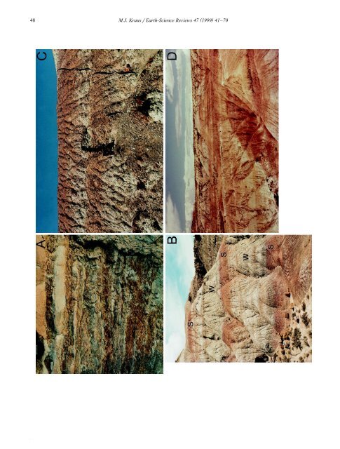
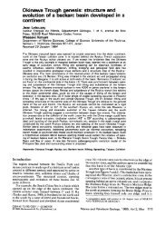
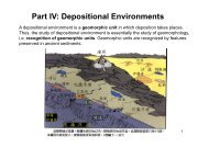
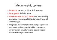
( )M.J. KrausrEarth-Science ReÕiews 47 1999 41–70 49floodpla<strong>in</strong> that underwent slow but relatively cont<strong>in</strong>uousdeposition. The other section had an unstablefloodpla<strong>in</strong> subject to periods of erosion, which mighthave been triggered by changes <strong>in</strong> climatic conditionsor vegetation cover.In fluvial systems, climatic change can also causefloodpla<strong>in</strong> <strong>in</strong>cision and terrace development. Althoughcommon <strong>in</strong> Quaternary fluvial systems, pre-Quaternary <strong>in</strong>cised floodpla<strong>in</strong>s and terraces are often<strong>in</strong>ferred, rather than directly observed Že.g., Wright,1992b .. This is presumably a problem of scale.Many outcrops are probably too laterally restrictedto allow large cut-and-fill features to be recognized.<strong>Paleosols</strong> may be especially useful for recogniz<strong>in</strong>gancient episodes of <strong>in</strong>cision and terrac<strong>in</strong>gŽ Figs. 1C and 3D .. For example, <strong>in</strong> a study ofEocene–Oligocene alluvial paleosols, BestlandŽ 1997.recognized several episodes of terrace formation,because each is marked by a strongly developedpaleosol <strong>in</strong>dicat<strong>in</strong>g lengthy pauses <strong>in</strong> sedimentation.As discussed <strong>in</strong> a later section, paleosols are also ofvalue for recogniz<strong>in</strong>g <strong>in</strong>cised valleys and terracesthat resulted from eustatic changes.F<strong>in</strong>ally, Retallack Ž 1998.has recognized sawtoothpatterns of development <strong>in</strong> sequences of paleosols.The paleosols <strong>in</strong> the sequence show a gradual upward<strong>in</strong>crease <strong>in</strong> <strong>their</strong> degree of development until amajor decl<strong>in</strong>e <strong>in</strong> development occurs. He provides anexcellent discussion of the mechanisms that couldproduce this k<strong>in</strong>d of pattern <strong>in</strong>clud<strong>in</strong>g: tectonic activity,sea-level fluctuations, and climatic changes.3.2. <strong>Paleosols</strong> associated with unconformitiesUnconformities usually represent significant hiatusesthat may last millions or even tens of millionsof years. They form when a period of landscapedegradation andror an episode of landscape stabilityis followed by sediment deposition. At least someperiod of landscape stability is needed for a soil todevelop on the unconformable surface. In some examples,paleosols mark<strong>in</strong>g regional unconformitiesare exceptionally thick and well developed, <strong>in</strong>dicat<strong>in</strong>glengthy periods of soil development and landscapestability Ž Fig. 1A .. For example, a PaleogeneOxisol described by Abbott et al. Ž 1976.is 30 mthick and this profile thickness was regarded as am<strong>in</strong>imum because the upper contact is an erosionalsurface.The formation of unconformities is controlled byallogenic factors such as sea level fluctuations, globalor regional climate change, and regional tectonics,processes that <strong>in</strong>fluence geomorphic systems over5 7time <strong>in</strong>tervals of 10 –10 years Že.g., Summerfield,1991 .. For example, the thick Paleogene paleosoldescribed above formed on a tectonically-generatedunconformable surface Ž Abbott et al., 1976 ., andDriese et al. Ž 1994. and Webb Ž 1994.documentedpaleosols that mark unconformities developed onlimestones exposed dur<strong>in</strong>g regressions <strong>in</strong> the LatePaleozoic. Although Driese et al. found that thesubsequent transgression partially eroded the soilthat developed, enough was preserved to dist<strong>in</strong>guishthe unconformity. As described <strong>in</strong> a later section,paleosols are be<strong>in</strong>g <strong>in</strong>creas<strong>in</strong>gly used to identifysequence boundaries and to subdivide a particularstratigraphic succession <strong>in</strong>to sequences.Unconformities are commonly regional <strong>in</strong> scale,and they can be highly irregular surfaces along whichthe amount of miss<strong>in</strong>g time varies considerably Že.g.,Wheeler, 1958 .. Consequently, the paleosol associatedwith an unconformity can show lateral changeson a regional scale, and those changes can be used to<strong>in</strong>terpret lateral variations <strong>in</strong> topography and miss<strong>in</strong>gFig. 3. Ž A.Levee deposits with weakly developed paleosols. Although the rock shows redden<strong>in</strong>g and root traces, relict bedd<strong>in</strong>g is apparentand <strong>in</strong>dicates that sedimentation was so rapid that the parent material did not undergo mix<strong>in</strong>g or homogenization. Lens cap at top of photo is6 cm <strong>in</strong> diameter. Ž B. Alternations of strongly developed cumulative paleosols Ž S. and weakly developed compound paleosols Ž W .. Thecumulative paleosols are dist<strong>in</strong>guished by gray A horizons overly<strong>in</strong>g thick red B horizons; they formed on floodbas<strong>in</strong> deposits. The weakpaleosols have pale colors and formed on what Kraus Ž 1996.<strong>in</strong>terpreted to be avulsion deposits. Ridge conta<strong>in</strong><strong>in</strong>g the paleosols is 18 mhigh. Ž C.Two vertically stacked compound paleosols formed on what are <strong>in</strong>terpreted as distal crevasse splay deposits. The paleosols showredden<strong>in</strong>g but are separated by rock that shows little pedogenic modification and is represented by white bands. The upper compoundpaleosol Ž orange and underly<strong>in</strong>g white band. is 47 cm thick and the lower is 50 cm thick. Ž D.Floodpla<strong>in</strong> <strong>in</strong>cision. Well-developed redpaleosols have been scoured and the scour filled with more weakly developed grayish paleosols. The scour cuts approximately 10 m down<strong>in</strong>to the red paleosols. All examples from the lower Eocene Willwood Formation, Bighorn Bas<strong>in</strong>, Wyom<strong>in</strong>g.