International Geoid Service (IGeS)
International Geoid Service (IGeS)
International Geoid Service (IGeS)
- No tags were found...

Create successful ePaper yourself
Turn your PDF publications into a flip-book with our unique Google optimized e-Paper software.
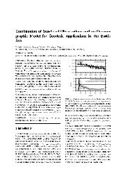
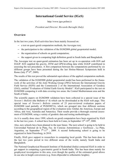
Report of the <strong>International</strong> Association of Geodesy 2007-2009 ─ Travaux de l’Association <strong>International</strong>e de Géodésie 2007-2009Thursday, September 18 th9:00 – 12:30 The Collocation Method in Geodesy (C.C. Tscherning)14:00 – 15:00 ExercisesFriday, September 19 th9:00 – 12:30 The FFT Methods in Geodesy (M. Sideris)14:00 – 15:00 ExercisesThe school was attended by 23 participants coming from 12 countries.Morning theoretical lessons were given at Palazzo Natta in the historical center of Comowhile afternoon computer exercise sessions were held in the computer center at the Politecnicodi Milano Campus in Como.The computer room is provided with 40 computers working with O.S. WinXP S.P.3, onwhich Fortran compilers and Phyton interface have been installed to use FORTRANprograms that usually run under Unix systems.As in previous geoid schools, students have been given Lecture Notes, with some upgradingas addendum, <strong>IGeS</strong> CD with software and data for exercises, the GRAVSOFT manual, and auser guide for FFT exercises. Moreover a final CD has been supplied with all the lecturespresented during the week.This school is going to be followed by two new schools in the near future. The first one willbe held at Universidad National de la Plata, Fac. de Ciencias Astronómicas y Geofísicas , LaPlata, Argentina, on September 7 th -11 th , 2009. Furthermore, a second has been planned inSaint Petersburg (Russia) and will be organized in 2010.4. Supporting geodetic activities in South India and BangladeshContacts have been established with the National Geophysical Research Institute of Hyderabad(India) and the Survey of Bangladesh. In both cases, a support was requested for geoidcomputation.In the South India area, a gravimetric quasi-geoid has been estimated in co-operation with theNational Geophysical Research Institute of Hyderabad that supplied 16013 gravity data (D.Carrion et al., Gravity and geoid estimate in South India and their comparison withEGM2008, Newton’s Bulletin, n°4 ,2009). Data over the surrounding seas were derived fromaltimetry (Andersen et al., Improved High Resolution AltimetricGravity Field Mapping(KMS2002 Global Marine Gravity Field) - A window on the Future of Geodesy, IAG symposium,128, 2005). The final global gravity data base consists of 63968 values.The standard “remove-restore” procedure was adopted to estimate this quasi-geoid; theresidual component was computed via Fast-collocation. The estimated quasi-geoid is plottedin Figure 4.Unfortunately, no GPS/leveling data were available and thus no tests on its accuracy werepossible. However, this can be considered a reliable estimate which will be used mainly ingeophysical investigation over the South India region.The co-operation with Survey of Bangladesh led to a geoid estimate based on GPS/levellingpoints used to refine the EGM2008 geopotential implied undulation. Survey of Bangladeshsupplied 155 GPS/leveling points: 110 were used in the computation while the remaining 45were considered as control points. The geoid residuals computed asΔNi= N ( GPS / lev)− N ( EGM 2008)ii
Report of the <strong>International</strong> Association of Geodesy 2007-2009 ─ Travaux de l’Association <strong>International</strong>e de Géodésie 2007-2009were interpolated on a regular 5’ grid covering Bangladesh. The final geoid estimate has beenobtained by adding, on the same grid points, the geopotential model component thus obtaining:Nˆgrid= Ngrid( EGM 2008) + ΔNˆgridΔNˆgrid= Collo(ΔN)iFigure 4. – The South India quasi-geoidThis geoid estimate improved the EGM2008 geoid estimate in this area. This has been provedby comparing the refined geoid estimate and EGM2008 on the 45 GPS/leveling controlpoints. The statistics of this comparison are shown in Table 7.
Report of the <strong>International</strong> Association of Geodesy 2007-2009 ─ Travaux de l’Association <strong>International</strong>e de Géodésie 2007-2009Table 7. – The statistics of the residual undulation over the 45 control pointsEGM2008N gridCheck points 45 45Mean (m) 0.010 0.018Standard dev. (m) 0.152 0.089Minimum (m) -0.292 -0.199Maximum (m) 0.358 0.237As one can see, a remarkable improvement in st. dev. is obtained using N grid . Contact withSurvey of Bangladesh will continue in the future with the aim of improving the geoid estimatein this area, also including gravity data that are going to be measured.