KOR TNO RK CDA ALM SVD KV RK KOR TNO CDA NOA ODN KAS
KOR TNO RK CDA ALM SVD KV RK KOR TNO CDA NOA ODN KAS
KOR TNO RK CDA ALM SVD KV RK KOR TNO CDA NOA ODN KAS
- No tags were found...

Create successful ePaper yourself
Turn your PDF publications into a flip-book with our unique Google optimized e-Paper software.
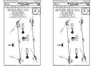
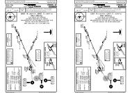
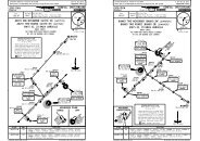
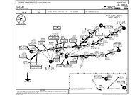
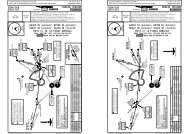
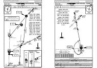
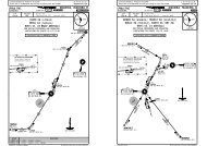
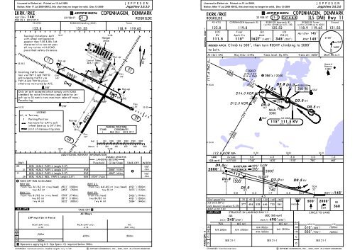
Licensed to Elefant air. Printed on 15 Jul 2009.Notice: After 17 Jul 2009 0901Z, this chart may no longer be valid. Disc 13-2009EK<strong>RK</strong>/<strong>RK</strong>EJEPPESENApt Elev 146'23 FEB 07 21-1N55 35.1 E012 07.9*D-ATISROSKILDE Handling (GND)Taxiing limitations: Acft 12-07 12-08with wheel configurationgreater than F-50 & BA-146HangarAreacharacteristics can not passHall twy curves with ICAOHprescribed safety distances.11115^03030^AElev127'JEPPESENJeppView 3.6.3.0J HRun-upRun-upControl Tower H55-35.5AIS + METB1D AA5B2BIncoming traffic shallE 1Elevtaxi via TWY C and TWY D ElevG A4146'and outgoing traffic via 145'CDTWY A and TWY B unlessB3FBotherwise instructed by ATC.B258'AB Run-upOnly jet acft accepted which comply with ICAOstandard for noise limitations (applicable for jetacft up to 34 metric tons maximum take-off mass).B4 B5Parachuting.A3 ARPElev55-35 299'138' 55-35LEGENDA1, A Taxiway1 Parking PositionTaxiroute for CAT C acft(wheel base up to 59'/18m)5902' 1799mRun-upA2A14921' 1500mCOPENHAGEN, DENMA<strong>RK</strong>ROSKILDEMeters 0 200 400 600 800 100012-07 12-08ADDITIONAL RUNWAY INFORMATIONUSABLE LENGTHSLANDING BEYONDRWYThreshold Glide Slope TAKE-OFF WIDTH03 HIRL HIALS PAPI-L (angle 3.0^)105'21 HIRL HIALS PAPI-L (angle 3.0^)RVR3888'1185m32m111 HIRL HIALS PAPI-L (angle 3.0^) RVR4869' 1484m105'29 HIRL HIALS REIL PAPI-L (angle 3.0^) RVR 5709'1740m32m1 TAKE-OFF RUN AVAILABLERWY 03:RWY 21:From twy A1/A2 int (rwy head) 4921' (1500m) From twy A4/A5 int (rwy head) 4921' (1500m)twy A3 int2493' (760m)twy B int3675' (1120m)RWY 11:RWY 29:From twy B1/B2 int (rwy head) 5709' (1740m) From rwy head5902' (1799m)twy B3 int3871' (1180m) twy B4/B5 int4921' (1500m)twy A int2625' (800m)twy A int3084' (940m).JAR-OPS.123.8 131.55118.9 119.65Limit of manoeuvring area.LVP must be in Force1All RwysTAKE-OFFTower21210^PA<strong>RK</strong>ING POSITIONSSTAND COORDINATES1 N55 35.4 E012 07.7RCLM (DAY only)or RLRCLM (DAY only)or RLNIL(DAY only)AB250mC400m500mD300m1 Operators applying U.S. Ops Specs: CL required below 300m.CHANGES: Communications. Usable lengths rwy 11/29.| JEPPESEN SANDERSON, INC., 2000, 2007. ALL RIGHTS RESERVED.Feet029295^500 1000 1500 2000 250001^E3000Licensed to Elefant air. Printed on 15 Jul 2009.Notice: After 17 Jul 2009 0901Z, this chart may no longer be valid. Disc 13-2009BRIEFING STRIP TMPANS OPS 4EK<strong>RK</strong>/<strong>RK</strong>ED5.8 LOCD3.0 <strong>KV</strong><strong>KV</strong>LOC<strong>KV</strong>740'0.8 0.31.7 2.5 0.34.5Gnd speed-Kts70 90 100 120 140 160HIALSILS GS 3.00^orLOC Descent Gradient 5.2%377 484 538 646 753 861PAPIMAP at D0.5 <strong>KV</strong>STRAIGHT-IN LANDING RWY 11ILSLOC (GS out)DA(H) 345' (200')MDA(H) 490'(345')MaxABCDFULL ALS out ALS out Kts MDA(H)RVR 900m100 610' (464')RVR 550m RVR 1000mRVR 1500mRVR 1000m135 850' (704')JEPPESENJeppView 3.6.3.0COPENHAGEN, DENMA<strong>RK</strong>ILS DME Rwy 11JEPPESENROSKILDE23 FEB 07 21-2 CAT A & B*D-ATIS COPENHAGEN Approach (R) ROSKILDE Approach (R)(within 40 NM up to FL 100)123.8119.8125.52LOCFinalGSILSApt Elev 146'<strong>KV</strong>Apch CrsLctrDA(H)111.5 115^ 1627'(1482') 345'(200') RWY 145'MISSED APCH: Climb to 500', then turn RIGHT climbing to 2000'to Lctr.Alt Set: hPa117.4 <strong>TNO</strong><strong>TNO</strong>55-4055-3012.6300012.03000112.8 <strong>KOR</strong><strong>KOR</strong>LOC<strong>KV</strong> DME(GS out) ALTITUDE2000'.JAR-OPS.D9.0<strong>KV</strong>CHANGES: Communications.Rwy Elev: 5 hPa029^BASETURNRACETRACKFISKOD13.0 <strong>KV</strong>D12.6 <strong>TNO</strong>115^7.22000D14.0 <strong>KOR</strong>D12.0 <strong>KOR</strong>115^2.01500'D5.02000275^295^1 086^4.7 20001115^562'MHA2000275^295^500' 2000'CIRCLE-TO-LANDCSEE 21-1 SEE 21-1 SEE 21-1D269^359^1600'MSA <strong>RK</strong> Lctr11-50 12-00 12-105.0 4.0 3.0 2.0 1.01740' 1420' 1100' 780'460'LctrGS1627'Trans level: By ATCD9.0<strong>KV</strong>D5.8 D5.0<strong>KV</strong><strong>KV</strong>ILS DME115^ 111.5 <strong>KV</strong>2000'K VROSKILDE TowerGround(within 25 NM up to 4000')118.9 119.65 131.55ROSKILDER 368 K<strong>RK</strong>D3.0D0.5Trans alt: 5000'<strong>KV</strong><strong>KV</strong>554'D0.5TCH52'HazardBeacon1083'RT<strong>RK</strong>368VIS1500m1600m| JEPPESEN SANDERSON, INC., 2000, 2007. ALL RIGHTS RESERVED.0<strong>KV</strong>2100'RWY 11145'