(dipterocarps & non dipterocarps). - Sabah Forestry Department
(dipterocarps & non dipterocarps). - Sabah Forestry Department
(dipterocarps & non dipterocarps). - Sabah Forestry Department
- No tags were found...

Create successful ePaper yourself
Turn your PDF publications into a flip-book with our unique Google optimized e-Paper software.
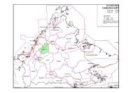
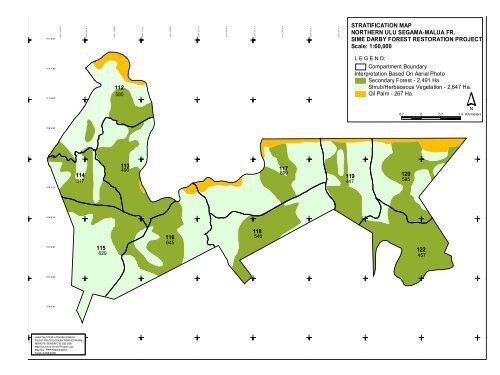
5° 05' 54.93"92 20 0 092 4 00 092 60 0 092 8 00 093 0 00 093 2 00 093 4 00 093 6 00 093 8 00 05 7 6 0 0 05° 11' 20.51"11 8° 00 ' 0 7. 4 8"11 8° 00 ' 3 9. 9 4"11 8° 01 ' 1 2. 4 0"11 8° 01 ' 4 4. 8 6"11 8° 02 ' 1 7. 3 3"11 8° 02 ' 4 9. 7 9"11 8° 03 ' 2 2. 2 5"11 8° 03 ' 5 4. 7 2"11 8° 04 ' 2 7. 1 8"11 8° 04 ' 5 9. 6 4"11 8° 05 ' 3 2. 1 0"STRATIFICATION MAPNORTHERN ULU SEGAMA-MALUA FR.SIME DARBY FOREST RESTORATION PROJECTScale: 1:60,00011 8° 06 ' 0 4. 5 7"11 8° 06 ' 3 7. 0 3"11 8° 07 ' 0 9. 4 9"11 8° 07 ' 4 1. 9 5"11 8° 08 ' 1 4. 4 1"5 7 6 0 0 05 7 4 0 0 05° 10' 47.95"5° 10' 15.39"112580L E G E N D:Compartment BoundaryInterpretation Based On Aerial PhotoSecondary Forest - 2,491 Ha.Shrub/Herbaceous Vegetation - 2,647 Ha.Oil Palm - 267 Ha.N0.7 0 0.7 1.4 Kilometers5 7 4 0 0 05° 09' 42.84"5 7 2 0 0 05° 09' 10.28"1143171134901176991194471205955 7 2 0 0 05° 08' 37.72"5 7 0 0 0 05° 08' 05.16"5 7 0 0 0 05° 07' 32.60"1156291166451185461224575 6 8 0 0 05° 07' 00.05"5 6 8 0 0 05° 06' 27.49"5 6 6 0 0 0JABATAN PERHUTANAN SABAHPUSAT PENYELIDIKAN PERHUTANANREMOTE SENSING & GIS LABMap Source:d:\frc\AVProject\.aprMap No.: PPP\RSGIS\0816Tarikh:03/06/20085 6 6 0 0 092 20 0 092 4 00 092 60 0 092 8 00 093 0 00 093 2 00 093 4 00 093 6 00 093 8 00 0