Forest Management Plan - Sabah Forestry Department
Forest Management Plan - Sabah Forestry Department
Forest Management Plan - Sabah Forestry Department

Create successful ePaper yourself
Turn your PDF publications into a flip-book with our unique Google optimized e-Paper software.
4.4.4 Assessment of HCVF Attributes 304.5 <strong>Management</strong> of HCVFs 345.0 SOCIO-ECONOMIC ENVIRONMENT 415.1 Survey Methodology 415.2 Objectives of the Survey 425.3 Social Based Line Survey Results 435.3.1 Ethnicity, Religion and Cultural Assets 435.3.2 Demographics 435.3.3 Village Leadership 445.3.4 Housing, Toilet and Water Supply 445.3.5 Public Infrastructure and facilities 455.3.6 Land use and Ownership 455.3.7 Source of Income 475.3.8 Natural Resources 485.4 Managerial Implications of Social Issues With FMU 17A 486.0 MANAGEMENT PRESCRIPTIONS 496.1 <strong>Forest</strong> Zoning 496.2 Conservation Areas 496.3 Timber <strong>Management</strong> 526.3.1 Liberation And Refinement Treatments 526.3.2 <strong>Forest</strong> <strong>Plan</strong>tations 556.3.3 Enrichment <strong>Plan</strong>ting 567.0 INFRASTRUCTURE MANAGEMENT 597.1 Roads 597.2 Buildings And Basic Facilities 598.0 MONITORING & PROTECTION 628.1 Monitoring 628.2 Operational Monitoring 628.3 Soil Protection And Watershed <strong>Management</strong> 628.4 Reporting 638.5 Compartment Register Book 648.6 <strong>Plan</strong> Review 648.7 Resource Monitoring 648.7.1 Continuous <strong>Forest</strong> Inventory & Permanent Sample Plots 648.7.2 Wildlife Monitoring 668.8 <strong>Forest</strong> Protection 668.8.1 Control of Boundaries 668.8.2 <strong>Forest</strong> Encroachment by Local Communities 672
8.8.3 <strong>Forest</strong> Protection and security 678.8.4 Fire Protection 688.8.5 Research & Development 699.0 MANPOWER AND BUDGET REQUIREMENT 719.1 Manpower Requirement 719.2 Budget and Cost Distribution 71List of TablesTable 2.1 Rainfall record of Tangkulap/Deramakot weather stationShowing average monthly rainfall (2002 – 2007) 5Table 2.2 Description of soils found within FMU 17A 8Table 3.1 <strong>Forest</strong> strata for FMU 17A interpreted from 5 mPanchromatic spot Image July 2003 13Table 3.2 Summarized inventory results for production compartmentsshowing the number of sound commercial trees ≥ 60 cm dbhper hectare 16Table 3.3 Summarized inventory results for Potential Crop Trees (PCT)
<strong>Plan</strong>ning Period 2006-2015 66Table 9.1: Manpower Requirement in FMU 17A for 2006-2015 72Table 9.2: Budget and Projected Cost (2006 – 2015) for FMU 17A 75List of FiguresFigure 1.1: Location Map FMU 17 A /B /C 2Figure 2.1: Fire Danger Rating for 2007 for Tangkulap & Deramakot FR 6Figure 2.2: Slope classification in FMU 17A 7Figure 2.3: Soil association in FMU 17A 9Figure 2.4: Original forest formation in FMU 17A 11Figure 3.1: 5m SPOT Satellite Image of FMU 17A 14Figure 3.2: <strong>Forest</strong> Stratum Map of FMU 17A 15Figure 4.1: Results of camera-trapping in Deramakot and Tangkulap<strong>Forest</strong> Reserves 26Figure 4.2: Location of HCVFs in FMU 17A 40Figure 5.1: Location of villages adjacent to FMU 17A 42Figure 5.2: Main road access to Kg. Karamuak 45Figure 6.1: Location of compartments in FMU 17A 50Figure 6.2: <strong>Forest</strong> land use in FMU 17A 51Figure 6.3: Schedule for liberation and refinement treatments forFMU 17A 54Figure 6.4: Compartments allocated for forest plantations andenrichment planting 58Figure 7.1: Road network 60Figure 8.1: Location of Permanent Sample Plots (15 m radius) 65Figure 9.1: Organizational Chart of DFR and FMU 17A (2006 – 2015) 74APPENDICESAppendix A – Rare, Threatened & Endangered Species list of Mammals 76Appendix B – Species List for Silvicultural Operations 78Appendix C – Standard Operation Procedures 81Appendix D - List of Compartments and Associated <strong>Forest</strong> Functionsin FMU 17A 86Appendix E – Harvest Schedule Projections Over a 40-year Cutting Cyclein FMU 17A 864
AbbreviationsAACADFOa.s.lAWPCFICHPCpt.CRPdbhDFODFREIAFMPFMUFSCFRFRCGFSHaHCVFHQITTOKg.MC&IMTCCMDFmmNFMNGOPCTR&DRILSFDSg.SFMSIATSIUFAnnual Allowable CutAssistant District <strong>Forest</strong>ry Officerabove sea levelAnnual Work <strong>Plan</strong>Continuous <strong>Forest</strong> InventoryComprehensive Harvesting <strong>Plan</strong>CompartmentComprehensive Restoration <strong>Plan</strong>diameter at breast heightDistrict <strong>Forest</strong>ry OfficerDeramakot <strong>Forest</strong> ReserveEnvironmental Impact Assessment<strong>Forest</strong> <strong>Management</strong> <strong>Plan</strong><strong>Forest</strong> <strong>Management</strong> Unit<strong>Forest</strong> Stewardship Council<strong>Forest</strong> Reserve<strong>Forest</strong> Research CentreGlobal <strong>Forest</strong>ry ServicesHectareHigh Conservation Value <strong>Forest</strong>Head QuartersInternational Tropical Timber OrganizationKampungMalaysian Criteria & IndicatorsMalaysian Timber Certification CouncilMixed Dipterocarp <strong>Forest</strong>millimeterNatural <strong>Forest</strong> <strong>Management</strong>Non-Governmental OrganizationPotential Crop TreeResearch & DevelopmentReduced Impact Logging<strong>Sabah</strong> <strong>Forest</strong>ry <strong>Department</strong>SungaiSustainable <strong>Forest</strong> <strong>Management</strong>Social Impact AssessmentTimber Stand ImprovementUltramafic <strong>Forest</strong>5
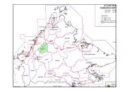
1.0: INTRODUCTION1.1 Purpose and Scope of <strong>Plan</strong>This revised <strong>Forest</strong> <strong>Management</strong> <strong>Plan</strong> is called the “10 -Year <strong>Forest</strong> <strong>Management</strong> <strong>Plan</strong> forTangkulap-Pinangah <strong>Forest</strong> <strong>Management</strong> Unit No. 17A”. It is a second official revision.The first official revision was carried out in 2008 and was approved by the Director of<strong>Forest</strong>ry on the 26 th February, 2009 from an earlier plan that was approved in 2006.This second revision <strong>Plan</strong> was done to mainly include certain issues that wereinadequately addressed in the first revision. The revised <strong>Plan</strong> defines the scope andprescribed activities for the management of FMU 17A over a 10-year period beginningfrom 1 st January, 2006 to 31 st December, 2015. The management of FMU 17A comesdirectly under the <strong>Sabah</strong> <strong>Forest</strong>ry <strong>Department</strong> and the Deramakot District <strong>Forest</strong>ryOfficer is responsible for the implementation of this FMP.Consistent with its legal designation as a Class II Production <strong>Forest</strong>, the primary longtermgoal in managing FMU 17A is to manage the forest based on integrated multipleuses of forest resources, including the sustainable production of timber, in compliancewith all existing rules, regulations and prescribed constraints. Although the statedplanning horizon is 10 years, the <strong>Plan</strong> seeks to optimize economic, social, andenvironmental benefits to the State, as well as to the other stakeholders, over andbeyond the current planning period.1.2 General backgroundFMU 17 consists of 90,635 ha, which is divided into 3 portions. These are FMU 17A(50,070 ha), which consists of Tangkulap <strong>Forest</strong> Reserve and Sg. Pinangah <strong>Forest</strong>Reserve (partly), which is located east or Karamuak River, FMU 17B that consists of32,010 ha of Sg. Pinangah <strong>Forest</strong> Reserve (partly), which is located west of KaramuakRiver and FMU 17C Sg. Mangkuwagu <strong>Forest</strong> Reserve (8,335 ha), which is located west ofSg. Pinangah FR (see Figure 1.1).This FMP will only cover FMU 17A. A large portion of FMU 17A is heavily degraded dueto poor logging practices in the past. Thus, intensive restoration in many compartmentsis needed to enhance the timber productivity of the area. The SFD has adopted a newmanagement planning approach that includes consultation with stakeholders through theestablishment of a Consultative Committee. Based on this consultative process, theinformation that follows in this 10 – Year <strong>Forest</strong> <strong>Management</strong> <strong>Plan</strong> (FMP) describes thesystem by which the SFD will pursue sustainable forest management (SFM). Therestoration of FMU 17A will have the goal of re-establishing high quality natural forestsintegrated with intensively managed planted areas. To ensure management standards ofhigh quality, the SFD will engage a third party certification body to certify the1
management of the FMU 17A according to FSC standards along with Climate, Communityand Biodiversity Project Design Standards (the “CCB Standards”) or Voluntary CarbonStandard for carbon sequestration as applicable.Figure 1.1: Location Map FMU 17 A /B /C1.3 Policy StatementThe SFD is committed to the basic principles of sustainable forest management, byensuring that activities in FMU 17A are environmentally appropriate, socially beneficial,and economically viable.The SFD’s forestry policy statements are as follows:• FMU 17A will be managed under sound forest management practices in accordancewith the <strong>Forest</strong> Stewardship Council (FSC) Principles and the biological, social andeconomic principles defined by the International Tropical Timber Organization(ITTO), the Malaysian Criteria and Indicators (MC&I) of the Malaysian TimberCertification Council (MTCC), now known as Malaysian Timber CertificationScheme (MTCS) and in conformity with the existing State forest policies,environmental policies, legislation and regulations.2
• The SFD is committed to support the effort to combat global warming in FMU17A through restoration activities and the establishment of intensively managedplanted areas that will sequester carbon and produce carbon credits in accordanceto CCB standards.• The SFD shall maintain and enhance areas identified as ‘high conservation valueforests’ (HCVF) for the protection of biodiversity, wilderness, soil, and waterresources;• The SFD shall consult with local, national, and international stakeholders in itsefforts to manage FMU 17A.• The SFD shall optimize economic returns to the State on a long-term basis byoptimizing the utilization and efficient use of raw materials from FMU 17A whilemaintaining conservation and environmental values, and providing social benefits.Social benefits will include job opportunities and socio-economic developmentactivities, particularly for the local communities who are living at the periphery ofFMU 17A, to improve their living standards.• The SFD will strive to protect its forest resources from fire, illegal felling andforest encroachment and to enhance the safe, sound, and responsible managementof the forest for this and future generations.1.4 <strong>Management</strong> ObjectivesTaking into account the State’s forestry policy and long-term goals, the specificobjectives over the 10-year planning period in managing FMU 17A are as follows:• To restore, maintain, and enhance key ecosystem functions and diversity at alllevels, including the conservation of water and soil resources, and wildlife;• To restore and enhance the timber production function of FMU 17A, whilstmaintaining a high degree of species, functional, and structural diversity.• To support research and educational activities; and• To integrate all forest operational activities within the concept of conservationand protection so as to reduce the impact to the environment from fire andencroachment.1.5 Legal FrameworkExisting laws and regulations on forestry are the legal instruments by which all forestryrelated activities are governed and regulated. <strong>Forest</strong> legislation reflects the principles3
of sustainability in order to support implementation of forest policy. <strong>Management</strong>guidelines, on the other hand, provide advice and promote more extensive application offorest management practices. In this context, the following are <strong>Sabah</strong>’s legal documentsand the SFD guidelines as they relate to the management of FMU 17A:i. State <strong>Forest</strong> Policy, 1954;ii. <strong>Forest</strong> Enactment, 1968;iii. <strong>Forest</strong> Rules, 1969;iv. Environmental Protection Enactment, 2002;v. Environmental Protection Enactment (Prescribed Activities), 2005;vi. Park Enactment, 1984;vii. Wildlife Conservation Enactment, 1997;viii. Land Ordinance, 1930;ix. Water Resources Enactment, 1998;x. State Cultural Heritage (Conservation) Enactment, 1997;xi. <strong>Sabah</strong> Conservation Strategy, 1992;xii. Biodiversity Enactment, 2000;xiii. Environment Protection Enactment, 2002• Environment Protection (Prescribed Activities) (EnvironmentalImpact Assessment) Order 2005;xiv. Environmental Quality Act, 1985;xv. RIL Operational Guide Book, 2009;xvi. Labour Ordinance (<strong>Sabah</strong>) Cap. 67;xvii. Employment Act, 1955;xviii. Occupational Safety and Health Act, 1994;• Occupational Safety and Health (use and Standards of Exposure ofChemicals Hazardous to Health) Regulations, 2000ix. International agreements such as CITES, ILO Conventions, ITTA, andConvention on Biological Diversity such as the following:• United Nations Convention on Biological Diversity, 1992;• Cartagena Protocol on Biosafety to the Convention on BiologicalDiversity, 2000;• Convention on Wetlands of International Importance Especially asWaterfowl Habitat, 1971;• International Tropical Timber Agreement, 1994; United Nations Framework Convention on Climate Change, 1992;• The Kyoto Protocol to the Convention on Climate Change, 1997;• Convention on International Trade in Endangered Species of WildFauna and Flora, 1973;• Core International Labour Organization (ILO) Conventions; and• United Nations Declaration of the Rights of Indigenous Peoples,2007.4
2.0: GENERAL INFORMATION2.1 Name, Location and Legal StatusThis revised management plan is prepared for FMU 17A, which comprises of Tangkulap<strong>Forest</strong> Reserve (27,550 ha) and part of the Sg. Pinangah <strong>Forest</strong> Reserve (22,520 ha).These forest reserves form a contiguous area of FMU 17A, which covers a total area of50,070 ha. The area is located at the central part of <strong>Sabah</strong>. Its geographical positionis between longitude 117° 02’ 32.43” E and 117° 22” 00.00” E and between latitude of 5°31’ 08.10” N and 5° 16’ 00.00” N (Figure 1.1). Sg. Pinangah FR was first established andgazetted as a Commercial FR in 1966 while Tangkulap FR was gazetted in 1962.2.2 ClimateThe entire FMU 17A generally experiences an equatorial climate characterized by warmand humid weather all year round.2.2.1 RainfallThe Southwest monsoon that occurs from May to August and Northeast Monsoon thatoccurs from November to February bring rains to the west coast and east coast of<strong>Sabah</strong>, respectively. The two inter monsoon periods (March to April and September toOctober) generally bring less rainfall.In spite of its remote inland location, Tangkulap receives abundant rainfall with a totalannual precipitation ranging between 2000 to 4000 mm. However, its monthly rainfallcan vary significantly from 33.0 mm to over 1000 mm (Table 2.1).Table 2.1: Rainfall record of Tangkulap / Deramakot Weather Station showing averagemonthly rainfall (2002 - 2007)YearMONTHJan Feb Mar Apr May Jun July Aug Sept Oct Nov DecVolume of Rainfall (mm)2002 203 192 155 368 589 442 329 519 435 630 198 196 42562003 336 454 206 115 78 156 298 341 391 143 229 1105 38522004 492 140 361 58 263 96 480 123 501 153 89 545 33012005 297 82 346 33 408 271 204 229 233 323 217 224 28672006 223 673 121 137 223 331 243 303 268 411 283 285 35012007 461 220 81 142 649 221 257 160 265 395 259 303 3413Average 335 293 212 142 368 253 302 279 349 342 212 443Total5
Based on the slope classification, approximately 92.3 % of the total area is considerablyundulating hills having slopes ranging from 0º to 25º, and the rest with slopes greaterthan 25º.Figure 2.2: Slope classification in FMU 17A2.3.2 GeologyGeologically, the area is formed by two different rock types namely, sedimentary rocksof the Kulapis Formation, which was probably laid down in the mid to late tertiary period(Eocene-Oligocene), and ultrabasic igneous rocks of the cretaceous to early tertiaryperiod. The Kulapis Formation consists of red calcareous sandstone, mudstone and shalewhile ultrabasic igneous rocks are composed largely of serpentinite, peridotite, duniteand pyroxenite.2.3.3 SoilsSoils within FMU 17A can be broadly divided into 6 main soil associations namely, Lokan,Bidu-Bidu, Dalit, Mentapok, Tawai and Binalik Association (Table 2.2 & Figure 2.3). A soilassociation is a grouping of soil units that occur together within landscape units withcharacteristic patterns of landform, parent material and vegetation.7
Table 2.2: Description of soils found within FMU 17ASoil LandformAssociationLokan Very highhillsBidu-BiduDalitMountainsand hillsModeratehillsParentMaterialMudstone/SandstoneUltrabasicIgneous RocksMudstone/SandstoneMentapok Mountains Basic igneousrocksTawaiBinalikPlateau withgentlyundulatingsurfaceValley floorsand terracesIronstone andAlluviumderived fromultrabasicrocksAlluviumderived fromultrabasicrocksMain Soil UnitOrthic AcrisolDystric CambisolRhodic FerralsolOrthic FerralsolEutric Cambisol ChromicLuvisol Orthic LuvisolLithosolOrthic AcrisolGleyic AcrisolChromic Luvisol, OrthicLuvisol, Eutric Cambisol,LithosolDystric Histosol, DystricCambisolOrthic FerralsolGleyic Luvisol,Ferric LuvisolOrthic LuvisolOrthic AcrisolsSoil FamilyTanjong LipatKumansi, LaabPinianakanAmbunBinuangMalawali TingkayuTanjong LipatMasaumBeestonKobovanBombalaiKaintanoMeliauNobusuNangohPantagaluang,NumatoiKataiThe Lokan Association is the most extensive soil (covering about 45% of the totalproject area) particularly at the eastern part of FMU 17A. It occurs in areas of highhills with altitudes up to 300m and slopes sometimes greater than 25 o ; hillcrests areoften very narrow. The hills are formed of interbedded sandstone and mudstone. Themain soil units are Orthic Acrisol of Kumansi and Tanjong Lipat Family and DystricCambisol of Laab Family.Bidu-Bidu Association occurs in the western part of the area with its landform made ofmountains and hills with ultrabasic igneous rocks parent material. Soil units of RhodicFerralsol of Pinianakan Family and Orthic Ferralsol of Ambun Family, Eutric Cambisol ofBinuang Family, Chromic Luvisol of Malawali Family and Orthic Luvisol of Tingkayu Familyand Lithosol are dominant in the association. Soils of this association generally have adark reddish brown color.8
Figure 2.3: Soil association in FMU 17ADalit Association occurs on moderate hills and minor valley floors, with altitudes of up toabout 75m and slopes generally between 10 o and 20 o . Sandstone and mudstone are thedominant parent materials with medium to coarse textured alluvium on the minor valleyfloors. The main soil units are Orthic Acrisol of Tanjong Lipat Family and Gleyic Acrisolof Masaum Family.Mentapok Association occurs on mountain ranges at the south-western part of theproject area. It composes of basic and intermediate igneous rocks. The main soil unitconsists of Chromic Luvisol of Beeston Family and Orthic Luvisol of Kobovan Family,Eutric Cambisol of Bombalai Family and lithosol.Tawai Association is restricted to the Tawai Plateau, which occurs at about 420 m a.s.lon the Tawai Range. The plateau is level to gently sloping and much is swampy; its surfaceis formed of ironstone and alluvium with very limited soil depth. The dominat soil unitsare Dystric Histosol of Kaintano Family and Dystric Cambisol of the Meliau Family.Binalik Association is found on valley floors and terraces of minor valleys in the vicinityof ultrabasic mountains at the northern part of the area. The main soil consists ofOrthic Ferralsol of Nobusu Family, Gleyic Luvisol of Nangoh Family, Ferric Luvisol of9
that provides the main forest structure and largely contributes to the stem numbers andbasal area. Dipterocarp species are also dominating the residual forest canopy.Figure 2.4: Original forest formation in FMU 17AThe second largest formation is ultramafic forest (UF), which once covered an area of13,403 ha (27 % of FMU 17A), mainly found in Sg. Pinangah FR. The ultramafic soils arecategorized as marginal, deficient in phosphorus, potassium and calcium; usually containhigh concentrations of magnesium, chromium, cobalt and nickel. These areas are usuallypredominated by a series of high ridges, steep slopes (above 25°) and V-shaped valleys.The coverage of lowland and upland UF areas are 5,896 ha (12 %) and 6,574 ha (13 %) ofthe total FMU 17A area, respectively.On higher elevations, the lower montane forest covers at least 114 ha or 0.2 % of FMU17A. In alluvial fans, which derive from upland or montane ultramafic soils, usuallyassociated with streams (Binalik Association), the forest is classified as lowland Alluvial-Ultramafic <strong>Forest</strong>. This forest naturally shows a broken canopy structure with amixture of tree species commonly found in MDF and UF, and pockets of open areainfested with climbing bamboos. To a small extent, the forest occurred on broad alluvialterraces to gentle undulating terrain. Collectively, the forest covered an area of 808 ha(1.6 % of total FMU 17A area). The Upland Kerapah-Ultramafic <strong>Forest</strong>, (1,128 ha) or 2.311
% of the total FMU 17A area is restricted to the northwest and extends to Tawai FRwith flat to gently sloping terrain.2.4.2 Diversity of FloraA survey conducted by the <strong>Forest</strong> Research Centre (FRC) has recorded a total number of1,502 plant species/taxa from 140 plant families (including those retrieved from theherbarium specimen record at SAN). Of these, a total of 160 species are endemic toBorneo, including 21 species that are endemic to <strong>Sabah</strong>. Most of the plant species underthis category are confined to ultramafic substrates around <strong>Sabah</strong> (e.g. Ulu Tungud, Mt.Silam, Kinabalu etc.). However, none of the species recorded from the survey is endemicto FMU 17A. Some fruit trees, like Durian (Durio spp.), Kawang (Shorea mecistopteryxand Shorea pilosa), Mango (Mangifera spp.), and Rambutan (Nephelium spp.) were found inthe area.Past logging activities are believed to have increased the threat to those plants thatwere identified or categorized as threatened species. Most of the identified endangeredspecies from the study are from the Dipterocarp family.2.5 Past <strong>Management</strong>2.5.1 Timber production and implicationsCommercial exploitation in FMU 17A started as early as the 1970s’. This forestexploitation continued until the year 2002. The issuance of short-term logging licensesat very short intervals, as well as poor logging practices, have resulted in over-logging.Historic records of the volumes of commercial timber extracted from FMU 17A are notcomplete. However, it is estimated that more than 6.0 million m³ of commercial timberwere removed from Tangkulap <strong>Forest</strong> Reserve since the early 70s’ equating to an averageof 120m3/ha being extracted.As such most of the forest area is considered degraded and would need timber standimprovement to enable harvesting to resume within the next 20 years. The main focus ofthe management system will be through restoration of severely degraded areas based onintensive methods such as planting of fast growing native species in blocks of about 30ha or less to form a mosaic of planted and natural regenerating forest areas.12
3.0: FOREST RESOURCES3.1 <strong>Forest</strong> StratificationBased on the visual interpretation of satellite images (5 m resolution Spot Image takenin July 2003 – Figure 3.1), the entire FMU 17A was initially classified into 5 differentforest strata (Figure 3.2). The criterion for stratification is based on the number oftrees ≥ 60 cm dbh (Table 3.1) as interpreted from crown size. Such an assessment isintended to provide an overall impression of forest quality and timber stock for theentire FMU 17A and was further evaluated through ground surveys to verify strataclassification.Table 3.1: <strong>Forest</strong> Stratum for FMU 17A as interpreted from 5 m Panchromatic SpotImage taken in July 2003Stratum <strong>Forest</strong> Description Number of trees ha -1≥ 60 cm dbhArea (ha) % of totalarea1 Good forest > 16 230 0.52 Moderate forest 9-16 3,510 7.03 Poor forest 5-8 15,670 31.34 Very poor forest 0-4 26,970 53.85 Small crown forest* NA 2,850 5.7Oil Palm <strong>Plan</strong>tation – Compartment 76 30 0.1Sub-Total 49,260 98.4Others: Infrastructure, roads, burnt area, etc. 810 1.6Total 50,070 100* Small crown forest: <strong>Forest</strong>s on ultrabasic soils where trees are naturally ofsmaller diameters, generally not exceeding 60 cm dbh.This approach to forest stratification is a standard method used by the SFD, mainly toprovide a quick assessment of the commercial potential of a forest area and to aid inidentifying areas suitable for timber harvesting. Based on the <strong>Forest</strong> Stratum Map, only0.5% of the area is classified as good forest, 7% as moderate forest, while about 85 %(42,640 ha) is classified as ‘poor’ (31.3 %) or ‘very poor’ (53.8 %). The rest of the area,which is about 7.5%, is classified as small crown forest (mainly upland ultramafic forest)and open or burnt areas. The overall interpretation indicates that merchantable timberstocking over a large part of the FMU is extremely poor.13
Figure 3.1: 5m SPOT Satellite Image of FMU 17A14
Figure 3.2: <strong>Forest</strong> Stratum Map of FMU 17A3.2 <strong>Forest</strong> InventoryAn inventory of timber resources was carried out over a period of 12 months, from April2003 to March 2004, covering all production compartments in FMU 17A. The inventorymethod used plots arranged continuously along a linear strip of up to 1 km in length. Alltrees > 40 cm dbh were enumerated on 10 x 20 m plots along the strip, while PotentialCrop Trees (PCTs = well-formed commercial trees with a minimum diameter of 5 cm)were selected within nested 10 x 10 m plots. Each compartment was inventoriedindependently using 3-6 linear strip lines, resulting in stand and stock tables forindividual compartments.The SFD assumes the standard that a compartment can be harvested when there is aminimum of 15 good quality commercial trees over 60 cm dbh per hectare. The SFD hasprojected the growth and mortality of each compartment in FMU 17A and has estimatedthe potential year of harvest for each compartment (see Appendix E). The projectionsshow that there will not be any harvesting within the next 10 years as much of the areahas been heavily logged over.15
The results of the inventory are provided in Tables 3.2 and 3.3 respectively.Based on the results of the inventory, there are no compartments that contain anaverage of over 15 trees/ha that could be ready for harvesting. Only small sections ofcompartments 5 & 32 are considered well stocked but these are too small to provide aneconomic harvest. Out of the 91 compartments 81 compartments are zoned forproduction. The inventory results identify that only 5 compartments are strata 3 thatcontain 5-8 commercial trees 60+ cm diameter per ha. The rest of the compartments areheavily degraded with less than 4 commercial trees 60+ cm diameter per ha. The SFDwill monitor the growth of trees using Permanent Sample Plots (PSP) and Continuous<strong>Forest</strong> Inventory (CFI) methods.Based on the results of the compartment level inventory, the SFD does not anticipateany commercial harvesting within the next 10 years under this management plan. Theemphasis of this management plan will be on rehabilitation of the FMU 17A throughsilvicultural treatments based on the density of potential crop trees (PCT) identifiedfrom the compartment level inventory (Table 3.3).Table 3.2: Summarized inventory results for production compartments showing thenumber of sound commercial trees ≥ 60 cm dbh per hectareCompt # 60-80 cmTree /ha80-120 cm Total/ha Area Stratum1 4.17 0.13 4.30 642.00 42 1.85 0.15 2.00 457.00 43 2.12 0.50 2.61 406.00 44 1.97 0.00 1.97 652.00 45 13.60 1.40 15.00 149.00 25 1.50 0.00 1.50 485.00 46 1.80 0.00 0.00 409.00 47 0.00 0.00 0.00 449.00 48 0.39 0.00 0.39 574.00 49 0.00 0.00 0.00 334.00 410 0.72 0.00 0.72 482.00 411 1.94 0.00 1.94 421.00 412 2.53 0.39 2.92 565.00 413 2.70 0.80 3.50 435.00 414 5.75 0.34 6.09 562.00 315 3.00 0.00 3.00 416.00 416 3.17 0.40 3.57 939.00 417 0.40 0.00 0.40 849.00 418 1.0 0 1.0 372.00 419 0.00 0.00 0.00 445.00 416
20 0.00 0.00 0.00 491.00 421 2.00 0.00 2.00 330.00 422 0.34 0.00 0.34 870.00 423 1.89 0.00 1.89 695.00 424 0.70 0.10 0.80 366.00 425 1.20 0.10 1.30 551.00 426 0.96 0.00 0.96 483.00 427 0.40 0.40 0.80 537.00 428 0.00 0.00 0.00 545.00 429 0.37 0.00 0.37 645.00 430 2.10 0.00 2.10 457.00 431 3.49 0.51 4.00 800.00 432 14.50 0.00 14.50 79.00 232 2.40 0.40 2.65 320.00 433 4.81 0.59 5.40 428.00 333 2.00 1.00 3.00 158.00 434 2.14 0.69 2.83 981.00 435 1.74 0.12 1.86 652.00 436 0.00 0.00 0.00 442.00 437 2.01 0.00 2.01 366.00 437 5.30 0.00 5.30 207.00 338 1.32 0.00 1.32 406.00 439 0.05 0.05 0.10 480.00 440 2.20 0.20 2.40 549.00 441 0.5 0 0.5 547.00 442 0.9 0 0.9 611.00 443 0.7 0.2 0.9 602.00 444 0.58 0.00 0.58 473.00 445 5.9 1.50 7.40 621.00 346 2.60 0.80 3.40 757.00 447 4.70 1.30 6.00 77.51 347 2.10 0.30 2.40 547.49 448 5.60 1.00 6.60 218.00 348 0.60 0.60 1.20 317.00 449 1.87 0.76 2.62 522.00 450 4.26 2.17 6.43 387.00 351 3.73 1.39 5.12 753 352 2.98 0.26 3.24 745 454 3.00 0.70 3.70 522 455 0.08 0.00 0.08 547 456 0.00 0.00 0.00 604 457 0.44 0.00 0.44 622 458 3.37 0.00 3.37 616 417
59 2.30 3.47 5.77 210 359 1.70 0.00 1.70 131 460 3.70 1.00 4.70 361 360 1.29 0.56 1.84 412 461 0.27 0.00 0.27 417.00 461 0.00 0.00 0.00 211.00 562 1.67 0.07 1.74 453.60 462 1.80 0.00 1.80 31.40 563 4.80 0.00 4.80 595.00 364 1.11 0.00 1.12 761.00 465 0.19 0.00 0.19 475.00 466 0.70 0.00 0.70 887.00 467 0.00 0.00 0.00 450.00 468 2.1 0.00 2.1 302.00 468 1.0 0.00 1.0 111.00 569 1.8 0.00 1.8 504.00 469 4.8 0.00 0.00 83 570 2.1 0.00 2.1 655.00 471 0.7 0.00 0.7 322.00 472 0.78 0.00 0.78 380.28 472 0.00 0.00 0.00 95.36 573 0.00 0.00 0.00 234.00 474 2.27 0.00 2.27 504.41 474 0.30 0.00 0.30 244.59 575 0.40 0.20 0.60 638.00 476 1.0 0.00 1.00 625.00 476 - - - 30 Oil Palm77 2.00 0.00 2.00 423.00 478 2.00 0.10 2.10 859.00 479 0.50 0.00 0.50 341.00 481 0.80 0.00 0.80 345.00 481 0.70 0.00 0.70 195.00 583 7.30 0.00 7.30 143.48 383 2.00 0.80 2.80 318.52 484 2.60 0.20 2.80 486.00 4Table 3.3: Summarized inventory results for Potential Crop Trees (PCT)
Compt #Trees / ha5-20cm 20-40cm 40-60cm Total/ha Area (ha)Strata19
1 36.57 29.44 11.89 77.89 642 42 26.16 29.69 14.16 70.01 467 43 33.08 24.53 13.68 71.29 406 44 32.08 26.31 10.92 69.31 652 45 30 43.60 25.00 98.60 149 25 27.00 27.00 12.00 66.00 485 46 13.40 7.34 2.56 24.30 409 47 28.01 29.49 4.20 61.71 449 48 20.96 7.64 10.40 38.99 574 49 14.30 9.60 2.90 26.80 334 410 22.52 14.55 4.94 42.01 482 411 32.12 16.07 5.60 53.79 421 412 26.72 14.86 2.73 44.32 508 413 55.80 19.90 10.80 86.50 435 414 52.06 29.62 9.50 91.19 562 315 43.50 24.00 11.80 79.30 416 416 50.06 17.25 8.40 75.72 930 417 59.90 23.00 9.20 92.10 849 418 60 30.80 - 90.80 372 419 17.20 7.10 0.90 25.20 445 420 13.20 4.90 1.00 19.10 491 421 9.90 8.60 5.20 23.70 330 422 30.28 21.53 3.77 55.58 870 423 23.47 14.83 4.67 42.97 695 424 13.50 18.90 2.90 35.30 366 425 25.00 16.40 9.90 51.30 551 426 41.60 30.40 6.00 78.00 483 427 12.40 17.70 5.30 35.40 537 428 16.90 9.20 2.30 28.40 545 429 21.24 21.85 5.57 48.65 645 430 23.59 10.28 0.19 34.06 467 431 26.38 12.80 5.82 44.99 800 432 69.00 74.00 18.00 161.00 79 232 58.23 8.30 9.78 76.30 320 433 45.48 26.55 9.41 81.45 428 333 64.00 24.00 14.00 102.00 158 434 14.78 14.40 5.79 34.97 981 435 39.25 48.60 4.42 92.28 652 436 17.12 19.72 4.23 41.08 442 437 15.13 22.89 13.80 51.82 366 437 18.10 25.30 8.70 52.10 207 338 13.41 10.34 2.30 26.05 406 439 13.36 8.98 1.46 23.80 480 420
40 14.90 15.20 2.70 32.80 546 441 37.40 13.30 - 50.70 547 442 33.30 22.30 - 55.60 611 443 26.50 13.00 - 39.50 602 444 23.00 20.33 6.37 49.69 473 445 14.02 26.58 7.54 48.14 393 346 46.90 24.60 9.50 81.00 757 447 18.70 9.20 7.30 35.20 77 347 18.10 14.10 5.20 37.40 547 448 19.20 17.60 7.00 43.80 218 348 3.40 17.40 3.90 24.70 317 449 19.04 18.98 7.54 45.57 522 450 46.07 24.35 8.84 79.26 389 351 15.28 24.74 6.94 46.96 753 352 25.06 17.29 5.30 47.65 725 454 28.80 21.80 6.60 57.20 522 455 13.82 6.80 7.17 27.79 547 456 20.30 15.20 6.40 41.90 604 457 49.89 38.44 7.60 95.93 622 458 33.86 13.01 5.81 52.68 616 459 29.83 17.91 5.96 53.70 210 359 27.70 6.60 5.00 39.30 131 460 14.00 17.50 5.30 36.80 361 360 5.65 16.50 3.97 26.12 412 461 43.00 68.70 6.00 117.70 417 461 16.70 38.30 4.60 59.60 211 562 50.49 60.89 3.89 115.28 453.6 462 53.60 59.70 6.40 119.70 31.4 563 57.50 44.50 11.00 113.00 595 364 28.46 17.28 10.72 56.46 761 465 14.68 26.06 5.66 46.41 475 466 21.52 26.67 1.45 49.64 887 467 13.30 15.40 0.30 29.00 450 468 24.40 26.40 - 50.80 302 4Table 3.3: continued68 - - - - 111 569 10.50 13.00 4.80 28.30 587 470 16.55 13.17 - 29.71 655 471 17.40 34.40 - 51.80 322 472 23.00 17.50 3.50 44.00 380.28 472 33.00 24.00 2.50 59.50 95.36 573 12.00 6.00 - 18.00 234 474 10.49 12.67 5.10 28.26 504.4 421
74 10 6.50 4.30 20.80 244.6 575 8.50 13.50 7.40 29.40 638 476 Burnt Burnt Burnt - 625 477 4.76 6.43 2.67 13.86 423 478 18.50 38.50 11.70 68.70 859 479 26.00 16.00 5.00 47.00 341 480 10.50 19.00 5.80 35.30 523.8 480 - - - - 245.2 581 18.80 20 14.80 53.60 345 481 20 21.40 9.30 50.70 195 583 18.00 42.80 5.30 66.10 143.5 383 14.68 20.06 3.66 39.41 318.5 484 37.60 33.60 14.40 85.60 486 4The results of the inventory on Potential Crop Trees indicate that much of the forest ispoorly stocked based on the stocking standards prescribed for Timber StandImprovement. A total of 24 compartments requires intensive restoration (less than 35PCTs/ha). Another 32 compartments are stocked with less than 50 PCTs/ha and mayrequire enrichment planting. The remaining compartments have sufficient stocking ofPCTs but should undergo climber cutting and possibly liberation thinning to release thesmaller PCTs from light competition with climbing bamboo and woody vines.3.3 Prospects for HarvestingBased on the forest field inventory, the prospects for harvesting over the 10-yearplanning period were evaluated. For this, growth projections of the inventory data weremade to determine when a compartment is likely to yield an economic harvest (AppendixE). Although the management planning period spans over a period of 10-years, growthprojections were made for one cutting cycle in order to ensure that harvesting issustainable over the long-term.For the purpose of yield regulation, a 40-year cutting cycle is assumed for thismanagement plan, and a minimum economic cut of 40 m 3 ha -1 is used to determine when acompartment is adequately stocked to justify a harvest. This translates to about 8-9good quality commercial trees ha -1 ranging 60 - 100 cm dbh. In general about 60% oftrees eligible for harvesting are actually not extracted due to defects and operationalconstraints. Taking these results into account a gross density of about 15 commercialtrees/ha is required for compartments to be ready for harvesting.Growth projections show that only 228 ha (within compartments 5 and 32) may beharvested after the 10-year planning period, and a total of 11,556 ha (23 %) may be22
harvested within one cutting cycle of 40 years. All other production compartmentsamounting to an area of 36,327 ha (73 %) are not expected to yield an economic cutwithin one cutting cycle. Therefore, areas within these compartments that are severelydegraded will be enhanced through intensive restoration for long-term sustained yieldsand income.Based on the inventory results as presented in Table 3.3 and growth projectionspresented in Appendix E, it is apparent that harvesting cannot be sustained over theplanning period. Therefore, under the current FMP, there will be no commercialharvesting operations except tree felling related to intensive restoration in appropriateareas. It can also be concluded that timber productivity for about 75 % of FMU 17A willneed to be restored by artificial means.23
4.0: ENVIRONMENT & HIGH CONSERVATION VALUE FORESTS4.1 Environmental IssuesExcessive logging, as well as, poor logging practices over the last 25 years have resultedin most of the forest of FMU 17A being degraded. Degraded forests are generally poorwildlife habitat and may exhibit greater environmental problems, such as erosion andsiltation of water bodies. The SFD will need to support the rehabilitation of FMU 17Awhere the forest as a whole is likely to take a long time to recover to its original stature.As such, no commercial harvesting is scheduled within the current 10 year planningperiod. The only harvesting planned within FMU 17A is from site preparation operationsfor 4 compartments (55, 56, 70 & 71), which have been set aside for intensiverestoration.4.2 Environmental Impact AssessmentThe SFD conducted an EIA in 2005 to evaluate the impacts of forest management onthe environment. In June 2009, an additional EIA report was submitted by MaxlandSdn. Bhd. and Syarikat Bumi Hijau, which were both approved by the EnvironmentalProtection <strong>Department</strong> in September 2009 and in October 2009 respectively. Both EIAreports define the management objective to support sustainable forest managementbased on the principles of multiple use, sustained yield of resources for economic, social& environmental purposes. One of the main elements of the EIA report in 2005 was asurvey using moths as an indicator species and a wildlife survey to evaluate theabundance of key wildlife species.4.3 WildlifeFMU 17A has been heavily logged, thus the residual forest is generally considereddegraded. However, wildlife in the forest reserve still exists but population densitiesare lower than those in neighboring Deramakot <strong>Forest</strong> Reserve.4.3.1 Wildlife SurveysThe evaluation of wildlife habitat and wildlife populations in FMU 17A is based on datagathered during the wildlife survey carried out in 2004 by 8 teams (4 members perteam), which comprised of staff from the Wildlife <strong>Department</strong> and the SFD. The surveywas carried out with emphasis on large mammals and birds by the identification of largemammal tracks, vocalization, faeces, claw marks, nests, direct sightings, etc. The method24
of the survey was based on a random line transect sampling (1 km/transect). The surveyteam covered 80 transects during the period of the field survey to determine thepresence of various wildlife and plant species.The survey results reported in the EIA report (Sept 2005) identified at least 34species of mammals (excluding bats), 146 species of birds and over 100 species ofreptiles, amphibians and fish. Among mammals, primate diversity is relatively rich.Elephants (Elephas maximus) and Tembadau (Bos javanicus) appear to use the generallyflatter parts of FMU 17A, which is at the eastern part that shares the commonboundary with DFR. Elephant range in the area extends from the Pinangah hills in thewest through parts of Tangkulap (west of DFR). Tembadau (Bos javanicus) together withlarge populations of sambar deer (Cervus unicolor) and the bearded pig (Sus barbatus)occur in the flat areas where grass is more prolific. Honey bear (Harlctos malayanus) andclouded leopards (Neofelis nebulosa) are also found in FMU 17A. Small carnivorediversity found in FMU 17A includes the leopard cat (Felis bangalensis), marbled cat(Felis marmorata), Malay badger (Mydaus javanicus), yellow-throated marten (Martesfiavigula), several species of civet and oriental small-clawed otters (Amblonyx cinena).Total bird species count during the survey was 146 species. However, one can expectmore over a longer sampling period. Six species of hornbills were sighted that includedlarge flocks of the rhinoceros hornbills (Anthrococeros coronatus).Orangutan (Pongo pygmaeus) - are fairly widespread in the western section of FMU 17Abut significantly lower if compared to DFR. Nests are commonly built on Laran andBinuang trees.Orangutan nest surveys have been conducted in a portion of Tangkulap FR every 6months since 2003 with the last survey conducted in November 2009 using helicoptersto count nests along fixed transects in both Deramakot and FMU 17 A. The SFD hasestablished up to 10 transect lines running north-south covering Deramakot FR &Tangkulap FR where 2 observers count nests with a maximum sighting distance of 100mfrom each side of the helicopter. The Orangutan density is estimated using the methods& formula developed by Ancrenaz et al., (2004 & 2005) to extrapolate nest counts alongaerial transects using helicopters flying over the tree canopy. The formula is as follows:Aerial Index = # of nests counted / length of transect (km) / 2D nests/km² = exp (4.7297+0.9796 * Ln (AI))D orangutan/km² = D nests/km² / prtWhere:p - proportion of nest builders in a population (p=0.9 in <strong>Sabah</strong>);r - daily rate of nest production (r=1.084 in <strong>Sabah</strong>); andt - nest decay rate (t=286.3 in <strong>Sabah</strong>,).25
The aerial surveys are taken about every six months in efforts to establish a long-termtrend in Orangutan populations. The results are subject to a number of elements such asweather conditions, average altitude of flight path over canopy, speed of helicopter andcanopy leaf fall of Laran trees thus, resulting in variable estimates over time and fairlylarge confidence intervals. The results of Orangutan surveys since 2005 are presentedin Table 4.1.Table 4.1: Summarized orangutan nest counts and estimated population density in FMU17ADateTransectLength(km)# NestsCountedAerialIndexNestDensity /km²OrangutanDensity/km²TotalApprox. #Nov 2009 51.37 387 3.77 415.2 1.49 746May 2009 51.37 248 2.41 268.5 0.96 481Nov 2008 16.98 179 5.27 577.1 2.07 467May 2008 51.37 96 0.93 106 0.38 190Nov 2007 16.98 99 2.92 323.1 1.16 262Aug 2007 19.8 82 2.07 231.1 0.83 187Nov 2006 19.8 89 2.25 250.4 0.90 203June 2006 19.8 101 2.55 283.4 1.01 228Nov 2005 19.8 92 2.32 258.6 0.93 210June 2005 19.8 83 2.10 233.8 0.84 189Tangkulap and Sg. Pinangah <strong>Forest</strong> ReserveTangkulap <strong>Forest</strong> Reserve onlyCamera trapping is currently being conducted in various parts of FMU 17A under theSFD & Center for Ecological Research Kyoto University Japan research programme. Thepreliminary results from camera trapping over a period of about 400 days in 2006 byHiromitsu Samejima - Center for Ecological Research, Kyoto University showed that thetotal number of records of animals sighted per camera day for Tangkulap FR was 0.105(see Figure 4.1 and Table 4.2). A total of 18 species were recorded for Deramakot<strong>Forest</strong> Reserve and 11 species were recorded in Tangkulap <strong>Forest</strong> Reserve.Meanwhile, the rare, threatened and endangered species in FMU 17A are listed inAppendix A.26
Figure 4.1: Results of camera-trapping in Deramakot and Tangkulap <strong>Forest</strong> Reserves27
Table 4.2: The frequencies and occupancies of middle-large mammals and terrestrialbirds captured by camera traps during 180 camera-days censusFrequencyAveraged number ofindividuals captured in 180camera-daysOccupancyProportion of census pointscaptured in 180 camera-daysFMU17a FMU19 FMU17a FMU19MammalsMoon Rat Echinosorex gymnurus 3.78 2.25 0.56 0.70Pangolin Manis javanica - 0.15 - 0.15Western Tarsier * Tarsius bancanus 0.89 0.15 0.44 0.10Long-tailed Macaque * Macaca fascicularis 0.22 0.25 0.11 0.20Pig-tailed Macaque Macaca nemestrina 4.00 4.15 1.00 0.90Orang-utan * Pongo pygmaeus 0.89 0.40 0.44 0.30Common Porcupine Hystrix brachyura 1.89 2.15 0.56 0.50Long-tailed Porcupine Trichys fasciculata 4.00 3.90 0.78 0.75Thick-spined Porcupine Thecurus crassispinis 0.11 0.50 0.11 0.25Sun Bear Helarctos malayanus 0.11 0.70 0.11 0.50Yellow-throated Marten Martes flavigula 0.11 0.30 0.11 0.20Teledu / Malay Badger Mydaus javanensis 0.89 2.15 0.56 0.55Oriental Small-clawed Otter Aonyx cinerea 0.44 - 0.33 -Malay Civet / Tangalung Viverra tangalunga 0.33 3.00 0.22 0.80Binturong / Bearcat Arctictis binturong - 0.05 - 0.05Common Palm Civet * Paradoxurus hermaphroditus 0.11 0.65 0.11 0.40Banded Palm Civet Hemigalus derbyanus 1.00 2.30 0.33 0.75Banded Linsang Prionodon linsang - 0.25 - 0.10Short-tailed Mongoose Herpestes brachyurus - 0.40 - 0.25Clouded Leopard Neofelis nebulosa 0.11 0.15 0.11 0.10Marbled Cat Felis marmorata - 0.10 - 0.10Leopard Cat Felis bengalensis 0.11 0.05 0.11 0.05Asian Elephant Elephas maximus 0.11 0.25 0.11 0.10Bearded Pig Sus barbatus 4.44 3.05 0.89 0.85Lesser Mouse-deer Tragulus javanicus& Greater Mouse-deer& T. napu8.33 15.35 1.00 1.00Bornean Yellow Muntjac Muntiacus atherodes 1.11 6.90 0.33 0.90Samber Cervus unicolor 0.67 1.55 0.33 0.70Tembadau Bos javanicus 0.11 0.20 0.11 0.10BirdsGreat Argus Argysianus argus 1.89 5.65 0.56 0.95Crested Fireback Lophura erthrophthalma 0.44 2.05 0.44 0.45Scaly-breasted Partridge Arborophila charltoni - 1.30 - 0.60No. of mammalian species 23 28No. of terestrial avian species 2 3*: Species known as basically aboreal28
4.4 High Conservation Value <strong>Forest</strong>s (HCVF)4.4.1 IntroductionIdentification of HCVF is a new and evolving discipline and therefore, there is no ‘right’way to perform an HCVF assessment. This makes identification of all potential HCVFattributes in FMU 17A challenging especially when detailed information about portions ofthe area are still lacking. Consequently, in this FMP, it only synthesizes existing data toidentify HCVFs within FMU 17A while the HCVF assessment should be considered as awork in progress, which will be refined as more information is available.Meanwhile, identification of HCFV is an important component of certification accordingto the standards of the <strong>Forest</strong> Stewardship Council (FSC). The FSC introduced theconcept of HCVFs in 1999. HCVFs possess one or more of the following attributes:• <strong>Forest</strong> areas having significant concentrations of biodiversity values (e.g. areas ofhigh endemism, areas known to support endangered species and areas rich inwildlife) – HCVF 1;• <strong>Forest</strong> areas in the form of natural forest cover where naturally occurringspecies exist in natural patterns of distribution and abundance – HCVF 2;• <strong>Forest</strong> areas that may provide representative samples of natural populations intheir undisturbed form (e.g. pristine forest) or forest areas that are in or containrare, threatened or endangered ecosystems – HCVF 3;• <strong>Forest</strong> areas that may provide basic services of nature and are sensitive todisturbance (e.g. watersheds, areas on steep slopes, areas sensitive to soilerosion) – HCVF 4;• <strong>Forest</strong> areas fundamental in meeting the basic needs of local communities (e.g.subsistence, protein, medicines, building materials, and clean water) – HCVF 5; and• <strong>Forest</strong> areas critical to local communities’ cultural integrity (e.g. areas of culturaland ecological significance) – HCVF 6.The first four attributes listed above focus on environmental HCVFs while the last two,are on social and cultural needs of the local communities.29
4.4.2 Identification of HCVFsIn 2009, GFS (Malaysia) Sdn Bhd was engaged by WWF (Malaysia) to assess HCVFs inFMU 17A of which the results of their assessment can be referred in their report“Evaluation of High Conservation Value <strong>Forest</strong>s FMU 17A Tangkulap & Pinangah <strong>Forest</strong>Reserves”, which was submitted to the SFD in September, 2009.Final identification of HCVF values as prescribed in this FMP is based on the SFD’sreport in November 2009, that is, “High Conservation Value <strong>Forest</strong> in FMU 17A” and thereport from GFS (Malaysia) Sdn Bhd. However, the report from the SFD differs in someinstances from those identified by GFS (Malaysia) Sdn Bhd. Generally there are fourreasons for these differences:a. Changes to the FSC Framework and questions;b. Change in scope of assessment – the SFD considers the FMU 17A areaonly;c. Lack of spatial data required to meaningfully identify habitats as HCVFs;andd. Decisions about focal species and judgements on definitions of ‘critical’ or‘outstanding’ values.Readers concerned about the differences between what is described in the SFD Reportand those reported by GFS (Malaysia) Sdn Bhd should consult both reports wherenecessary. Nevertheless, this FMP has summarized and refined the HCVF attributesidentified based on the two reports and prepared questions. A final map of HCVFattributes within FMU 17A area that will be managed by the SFD in accordance with therigorous standards of the FSC was prepared and is shown in Figure 4.2.4.4.3 MethodologyThe concept and methodology of the WWF-SFD’s conducted HCVF assessment of UluSegama-Malua SFM Project (USM) are utilised to assess the HCVF attributes in FMU17A. The presence of any High Conservation Value (HCV) elements was determined usingseveral methods as listed below: Using available information in SFD (forest reserve maps, satellite photos,topographic maps, stratum maps, etc.). EIA report (Sept 2005). Inventory of Timber Resources (April 2003-March 2004) covering all productioncompartments in FMU 17A. Wildlife Study by the Wildlife <strong>Department</strong> and several NGOs in Tangkulap FR andadjoining Deramakot FR.30
Camera trapping (SFD & Center for Ecological Research Kyoto University Japanresearch programme). Intellectual discussions with several ecologist and forest managers regardingvegetation and wildlife. The Social Baseline Study conducted by the SFD on villages located adjacent toFMU 17A. Field survey to verify the presence of all HCVF elements and gathering factualdata wherever possible.4.4.4 Assessment of HCFV Attributes4.4.4.1 HCVF 1 - Does the forest in FMU 17A contain globally, regionally or nationallysignificant concentrations of biodiversity?There is no significant concentrations of such biodiversity within FMU 17A.Nevertheless, the following have been identified and acknowledged on the presence ofbiodiversity:(i)Protected areasProtection <strong>Forest</strong> ReserveThere is no Protection FR within FMU 17A.Virgin Jungle Reserve (VJR)VJR Timbah (292ha) is a small VJR, which is to be gazetted in 2010, islocated west of Tangkulap FR (Cpt.53). It is the only less disturbed andwell conserved Lowland Mixed Dipterocarp <strong>Forest</strong> (MDF) in FMU 17A. Nodetailed faunal study was conducted in this area. Nevertheless, thisnatural forest has been a site for forestry training and education by the<strong>Sabah</strong> <strong>Forest</strong>ry Institute. The site is also important for forestryresearch particularly on the issue of an intact forest ecosystem within thedisturbed surrounding forest areas.Land above 25 o slopeThere are approximately 7,960 ha of forests located at the north-westernpart of Sg. Pinangah FR, that is, between Sg. Karamuak and Sg. TangkulapBesar, which have slopes above 25 o . The existing forest type in theseareas is mainly mixed-dipterocarp forest, which is fragmented due to poorlogging practices in the past and forest fires. The areas will be conserved31
and protected for the conservation of flora and fauna of naturalimportance and interest.Riparian reserveFMU17A is drained by 2 major rivers, namely, Sg Karamuak and SgTangkulap Besar. Along these rivers and their major tributaries, there willbe at least 30 meters of riparian reserves, which are to be maintained andprotected. Maintaining the 30 m riparian reserves along the rivers isimportant in order to minimize soil run-off and also to serve as a filtrationsystem to preserve the quality of water entering the rivers.Stratum 1 & 2Especially for FMU 17A, intact ecosystems may only be found in Stratum 1and to some extent Stratum 2. Therefore, the protection of theseremaining ecologically superior areas is necessary whether for germplasmconservation or wildlife refuge. There are 234 ha of Stratum 1 and 3,510ha of Stratum 2 in FMU 17A.(ii)Concentrations of threatened or endangered speciesAs prescribed in 4.3.1, FMU 17A is home to large mammals particularlyorangutans (Pongo pygmaeus), pygmy elephants (Elephas maximus) andtembadaus (Bos javanicus). Orangutans are mostly found fairly widespreadin the southern part of Tangkulap FR but significantly lower in numbers ifcompared to DFR. The pygmy elephants, tembadaus and other largemammals on the other hand, appear to use the generally flatter parts ofFMU 17A (where shelter and food are aplenty) and those with mildlyundulating terrain below 200 m asl. Most of these undulating terrains existin Tangkulap FR that shares the common boundary with DFR. The rangesare within the Sg. Tangkulap Besar in the north and Sg. Karamuak in thesouth (see Figure 4.2). Meanwhile, like in DFR, saltlicks are believed to bequite common in FMU 17A. However, their exact locations are yet to bedetermined. This will be done during the plan period.The entire FMU 17A area is generally logged over forests and therefore,the presence of threatened and endangered plant species is regarded asnot significant. Nevertheless, the entire forest area of FMU 17A can stillserve as a habitat for wildlife particularly rare, threatened & endangeredspecies (RTE) – see list in Appendix A.32
(iii)Concentrations of endemic speciesA consultation with our <strong>Forest</strong> Ecologist and other Research Officersfrom the <strong>Forest</strong> Research Centre who know FMU 17A well, concludedthat the possibility of endemic species, whether fauna and flora, in FMU17A is highly unlikely.(iv)Seasonal concentrations of speciesGround information (through sightings and frequency) gathered revealsthat large mammals such as the elephants, tembadaus and orangutans showseasonal movement within FMU 17A. However, further scientific researchneeds to be carried out to positively determine all the exact and potentialroaming routes of the elephants and tembadaus. Seasonal roaming oforangutans can be detected by scheduled nest count based on aerialsurveys using helicopters.4.4.1.2 HCFV 2 – Are there forest areas in FMU 17A, which are in the form ofnatural forest cover where naturally occurring species exist in naturalpatterns of distribution and abundance?There is no contiguous area of forest more than 20,000 ha in FMU 17A that can becategorized into this HCV.4.4.1.3 HCFV 3 – Does the forest in FMU 17A contain nationally/regionally significantdiverse or unique forest ecosystems or naturally rare, threatened orendangered ecosystem types in FMU 17A?(i)Previously widespread forest typesAll forest areas below 200 m asl in FMU 17A have been classified as lowmixed-dipterocarp forests but have declined due to conventional logging inthe past. This forest type, however, is expected to increase on thelandscape over the next 40 years.(ii)Localised forest typesSg. Pinangah FR contains several sensitive and localised forest types.These include the Kerapah <strong>Forest</strong> (1,128 ha), Lowland Ultramafic <strong>Forest</strong>(5,896 ha), Lowland Ultramafic <strong>Forest</strong>-Alluvial (819 ha), Upland Ultramafic<strong>Forest</strong> (6,574 ha) and Lower Montane Ultramafic <strong>Forest</strong> (114 ha). All these33
forest types are located at the north-western part of Sg. Pinangah FR andsouth of Tawai FR.There are also 149 ha of Lowland Seasonal Freshwater Swamp <strong>Forest</strong>s atthe south of Tangkulap FR near Kg Kenang-Kenangan. All these areas aresensitive to vegetation changes and, therefore, need to be conserved.4.4.1.4 HCVF 4(i)Does the forest in FMU 17A provide a significant source of drinkingwater?For the immediate purpose of the community living adjacent to FMU 17A,some compartments such as, Cpts. 22-23 in Tangkulap FR may providewatershed for gravity-water for Kg Tamoi (Kenang Kenangan). The localcommunities in Kg. Karamuak may get their good quality water supply fromGunung Tingkar FR, which is located in FMU 17B.(ii)Are there forests in FMU 17A critical to erosion control?Logically, this element applies primarily to areas where forest harvestingoperations will have significant adverse impacts downstream. Thisattribute overlaps with elements 4.4.1.1 (i), 4.4.1.3 (ii) and 4.4.1.4 (ii) above.(iii)Are there forests in FMU 17A that provide a critical barrier todestructive fire (in areas where fire is not a common natural agent ofdisturbance)?This include all forest edges that are adjacent to human settlements andplantations, and also major roads within FMU 17A. With this definition, allforests within compartments bordering with villages, plantation estatesand all major roads such as Maxland Road, Tangkulap-Deramakot Road,Waja Kaya Road, Bountiful Return Road and Borneo Glow Road will servethe function as natural fire barriers.4.4.1.5 HCVF 5 – Do the forests in FMU 17A provide the basic needs of localcommunities (e.g. subsistence, protein, medicines, building materials, and cleanwater)?Compartments 22-23 are the watershed areas for the communities living in Kg. Kenang-Kenangan. The other villages do not directly depend on FMU 17A for their clean watersupply. The villagers in Kg. Entilibon Asal and Kg. Entilibon Simpang obtain their clean34
water from Tawai FR and Sg. Karamuak of which the main watershed area for the latteris Trus Madi FR. Subsistence farming is carried out within the statelands. So basically,FMU 17A does not significantly contribute to the basic needs of the local communities.4.4.1.6 – HCVF 6 – Are the forests in FMU 17A critical to local communities’ culturalintegrity?So far, no important cultural sites have been identified inside FMU 17A. However, thereare some caves with burial sites located along Sg Millian, which is outside the boundaryof FMU 17A.4.5 <strong>Management</strong> of HCVFs<strong>Management</strong> of some potential values of HCVFs is extremely challenging if spatialinformation about the location of these values is lacking. Thus, in this FMP, only theidentified HCVFs mandate for a precautionary approach for management of values, andtherefore, require a high level of monitoring and mitigation measures to ensure themaintenance of these values (see Table 4.3).Areas defined as sensitive or unique for specific elements are under conservation andwill not be disturbed by forestry operations (see Figure 6.2). Areas >25 o slopes areconsidered as too steep and will be protected from future logging and excluded from anyclearing. Compartments that have an average slope that is >25 o will be protected asconservation areas. Buffer zones to protect rivers, streams and riparian areas will beidentified, shown on a map and recorded according to forestry operational procedureslisted in Appendix C.For large mammal populations, habitat contiguity in the form of natural forest cover iscritical in ensuring the long-term prospects of viable populations. As a rule of thumb, thearea required for viable mammal populations such as elephants, is approximately 50,000 -100,000 ha. FMU 17A is fortunate because it shares a common boundary with DFR (onthe west) and Tawai FR (on the north), which can provide better wildlife habitatcontiguity. Since there are no plans for timber harvesting during the plan period, it isanticipated that there will be minimum disturbance to wildlife movements in the area.Likewise, the SFD plans to support conservation through rehabilitation of the forest intoa productive natural forest that meets international certification requirements such as,those fulfilled by the Deramakot <strong>Forest</strong> Reserve.<strong>Management</strong> of the conservation values based on HCVFs will include a number of keyattributes associated with planned rehabilitation activities as defined in thismanagement plan and in the operational procedures.35
Table 4.3: Summary of HCV in FMU 17A and the management and mitigation measuresHCV Element Definition Location / Remarks <strong>Management</strong> and Measures tomaintain HCVs.1BiodiversityProtectedAreasThreatened &endangeredspecies (largemammals)(a) Protection <strong>Forest</strong> Reserve. NIL in FMU17A. NIL(b) Virgin Jungle Reserve. VJR Timbah (292ha). <strong>Forest</strong> Protection (boundary patrol,etc.).(c) Sensitive areas identifiedfor conservation and based onminimizing impacts fromforestry operations such asprotection of steep slopes (>25 o )and 30 m buffer zones forstreams (50m in compartmentsunder the mosaic system).(d) Land within 30 m of bothsides of all permanent riversand streams as required in RIL(e) Land classified underStratum 1 and 2.7,960ha at the north-westernpart of Sg. Pinangah FR,between Sg. Karamuak and Sg.Tangkulap Besar.2 major rivers, Sg Karamuakand Sg Tangkulap Besar andtheir major tributaries.Stratum 1 (234 ha) andStratum 2 (3,510 ha).Prohibition of all or majority ofharvesting activities will be enforcedwithin conservation areas.No logging activities within the 30 mzone.No logging at all in Stratum 1 (futureseed source), but for Stratum 2,forest harvesting should strictlyfollow RIL Techniques. <strong>Forest</strong>rehabilitation and silviculture arenecessary.(a) Orang-utan. Area below 200m a.s.l. Timber production with RIL methods,and/or rehabilitation whereappropriate.(b) Pygmy Elephant. Area below 200m a.s.l. None, as elephants can utilise openforest conditions.36
(c) Tembadau (wild cattle). Area below 200m a.s.l. None, as tembadaus can utilise openforest conditions.2Largelandscapeforests3Rare,threatened &endangeredecosystemsThreatened &endangeredspecies(plants)EndemicspeciesCriticaltemporalconcentrationsExtensiveundisturbedforestsPreviouslywidespreadforest typewhich hasbeensignificantlydepleted byconversion andunsustainableharvesting.(d) Natural mineral sources (saltlicks, kaolin clay).The entire FMU 17A area, whichconsists mainly of lowlandmixed-dipterocarp forest.Species confined to FMU 17A.Assumed not applicable in FMU17A.Any contiguous area of forestmore than 20,000 ha in extentwhich is either known to havenever been logged and/or ispredominantly Stratum I.<strong>Forest</strong>s below 200 m a.s.l.Area below 200m a.s.l.Not significant.None known in FMU 17A, butfuture study may reveal suchspecies.None known in FMU 17A.There is no large landscapelevel in FMU 17A that can becategorized into this HCV.All forest area below 200m a.s.lin this FMU fit to be classifiedinto this HCV.37No logging activities within the 5 haarea. Mark a zone of about 5hectares around or preserved with100 m radius buffer zones all knownlocations (with GPS readings).Timber production with RIL methods,and/or rehabilitation/silviculturewhere appropriate.Case-by-case.Case-by-case.NILAll forest harvesting must complywith RIL Procedures. <strong>Forest</strong>Rehabilitation needs to be carriedout where appropriate using nativespecies mixed with 15% of treespecies identified as habitat/fruiting trees. Silvicultural tendingthroughout the FMU is verynecessary to enable regenerationand/or growth of Potential Crop
Trees. Silvicultural climber cutting isdone by cutting of larger woody vines& climbing bamboo (>0.25 cmdiameter) to limit competition withpotential crop trees and enhancelight penetration through the canopyshould increase growth of youngshoots. Small vines remain as foodfor elephants and other animals.Severely degraded forestsbelow 200m a.s.l.Mosaic system – small areas (
Alluvial (819 ha). Upland Ultramafic <strong>Forest</strong>(6,574 ha). Lower Montane Ultramafic<strong>Forest</strong> (114 ha). Lowland SeasonalFreshwater Swamp <strong>Forest</strong>(149 ha).4EnvironmentalservicesWatercatchmentsAreas identified as “importantwater catchments”, plus all landabove 25 o slope.Tangkulap FR - Cpts 22 and 23near Kg Tamoi/Kenang-Kenangan.No logging and no roads exceptexisting roads where no reasonablealternative route is possible.Soil erosioncontrolFire barriersAreas identified with higherosion risk, plus all land above25 o slope, plus other specificareas where strict control ofland use is necessary tominimise soil erosion.Areas where there is believedto be a high risk of firespreading during dry periods.Conservation areas and areas>25 o slopes.All compartments borderingwith villages and plantationestates.No logging or low intensity ofharvesting following RIL methods.Case-by-case.5Local peopleneeds<strong>Forest</strong> areasused by localpeople<strong>Forest</strong> areas used by natives forlegally sanctioned purposes.<strong>Forest</strong>s along roads such as,Maxland Road, Tangkulap-Deramakot Road, Waja KayaRoad, Bountiful Return Road,Borneo Glow Road may functionas natural fire barrier. Cpt 91 adjacent to KgEntilibon Asal and Cpt 22 near KgTamoi/Kenang-Kenangan.No logging, but enrichment plantingand silviculture tending areencouraged, together with the localcommunities.39
6CulturalidentitySites“critical” toculturalidentityA site is critical when change toa forest can potentially cause anirreversible impact to localculture.As so far, no important culturalsites were identified withinFMU 17A.Case-by-case40
Figure 4.2: Location of HCVFs in FMU 17A41
5.0: SOCIO-ECONOMIC ENVIRONMENT5.1 Survey MethodologyThere is no village located within FMU 17A. Therefore, the socio-economic assessmentbased on social baseline survey methodology was conducted in all villages located at thevicinity of FMU 17A (see Table 5.1 and Figure 5.1). The survey was conducted by GFS (M)Sdn Bhd (an appointed consultant) with the help of the SFD field staff from 1 st to 4 thJuly, 2008 in 6 villages. The results of the survey were prepared by GFS (M) Sdn Bhdand reported in their report “Evaluation of High Conservation Value <strong>Forest</strong>s FMU 17ATangkulap & Pinangah <strong>Forest</strong> Reserves”.The study employed both the qualitative and quantitative approaches. In the qualitativeapproach, information on observations of the local people was gathered by theconsultant. This was to ensure that the views and experiences of the local people werecaptured accurately. On the other hand, the quantitative approach would allow theconsultant to collect the data by assigning numerical values to concepts under study andanalyse it objectively. The questionnaire developed is based on the “Social ImpactAssessment” form developed by the consultant.Besides individual interviews, focus group interviews were also carried out to identifyand assess community needs and resources. The group interviews took place in therespective village main hall (dewan) where all members of the community of the villagewere invited to attend. The survey was conducted through a general meeting, as well as,by visiting individual households based on Procedure #2 – (Appendix C). The collectionof information and sampling of viewpoints were taken from men and women within thevillage besides the village leaders.Table 5.1: List and location of the villages surveyed adjacent to FMU 17A# Villages GPS location1 Kg. Kenang-Kenangan (Kg. Tamoi) N 05° 18’ 09.4”, E 117° 15’ 08.5”2 Kg. Karamuak Dalam N 05° 17’ 26.2”, E 117° 12’ 40.4”3 Kg Karamuak Luar N 05° 17’ 00.6”, E 117° 12’ 32.9”4 Kg Entilibon Asal Tongod N 05° 31’ 38.5”, E 117° 02’ 37.3”5 Kg. Entilibon Simpang N 05° 31’ 11.2”, E 117° 02’ 33.6”6 Kg. Tenaga Baru & Mapad N 05° 17’ 09.0”, E 117° 11’ 17.0”42
Figure 5.1: Location of villages adjacent to FMU 17A5.2: Objectives of the SurveyThe objectives of the survey are as follows:a. To listen to the local communities’ concerns on forestry operations in FMU17A and how these affect them;b. To gather social information about the local communities living at thevicinity of FMU 17A and determine their needs and priorities, especiallythat concern with the three recognized forms of HCVF, that is, HCVF 4, 5and 6; andc. To define and quantify (where appropriate) the potential impacts offorestry operations and define means to mitigate any negative impacts onthem.43
There were several key elements evaluated in the survey, which amongst them are thefollowing:• Population and land ownership;• Community livelihoods;• Cultural aspects;• Social needs; and• Community conservation needs5.3 Social Based Line Survey ResultsThe villages identified during the survey are listed in Table 5.1 and their locations areshown in Figure 5.1 respectively. All villages surveyed are located outside FMU 17A.There are no villages located within FMU 17A.5.3.1 Ethnicity, Religion and Cultural AssetsThe communities comprise only one ethnic group, namely, Dusun Sungai (or Dusun Sg.Kinabatangan). The majority of the people are Christians.The natural heritage of the local communities consists of their cultural-ecology of theriverine system, rice-fields and fallowed lands. Over the years, the communities haveaccumulated knowledge of adapting and utilizing the natural resources of theseenvironments. This vast knowledge would be lost with the passing on of the oldergenerations and the diminishing environments due to development projects. This is nowobvious in Kg. Entilibon Asal and Kg. Entilibon Simpang. For example, the useful knowledgeof ethno-botany for local medicinal use and the understanding of the workings of theenvironment would soon be lost with the passing of time.5.3.2 DemographicsThe average population of the villages is approximately 1,075 people with an averagefamily size of about 5 – 10 people. The most populated villages are Kg. Entilibon Asal(approx. 4,000 people) and followed by Kg. Entilibon Simpang (933 people) and Kg.Karamuak Dalam (680 people). However, the majority of the people are not physicallystaying in the villages. Most of the teenagers go to secondary schools in Telupid (stayingin the hostel), while young adults move to urban areas or oilpalm plantations to work. Thelocal communities’ breakdown is shown in Table 5.2. Based on Table 5.2, it is apparentthat the population of the communities is increasing.44
Table 5.2: The population breakdown according to village adjacent to FMU 17AVillagePopulation*# ofHouseholdVillage Description# of Household 10years agoAverageppl/houseKg. Kenang-Kenangan 300 52 40 6Kg. Karamuak Dalam 680 136 120 5Kg. Karamuak Luar 328 60 27 5Kg. Entilibon Asal 4,000 400 200 10Kg. Entilibon Simpang 933 180 100 6Kg. Tenaga Baru & Mapad 210 32 10 7Total 6,451 860 497Note: * This includes children/teenagers/young adults who are not residing in thevillage.5.3.3 Village LeadershipAll surveyed villages have an arranged leadership structure, which is led by the VillageHead (Ketua Kampung) and JKKK Chairman. All the leadership positions are held by men,while the involvement of women is lacking. Usually, the Ketua Kampung is elected and heis skilled in adat – the native law. Similarly, the JKKK Chairman is also elected by thevillagers. The main functions of the JKKK (or Village Security and DevelopmentCommittee) are to serve the villagers and to secure development and safety in thevillage.5.3.4 Housing, Toilet and Water SupplyMost families live in a separate house with their immediate family including children andparents. It is common to have up to 6-8 people living in one house. Types and quality ofhouses vary among each family but are generally constructed of wood, bought fromtimber suppliers or sawmills or collected from the forest (Stateland). Most houseconditions in Kg. Entilibon Asal and Kg. Entilibon Simpang are of good condition and clean,indicating that the local communities are financially “well off”. The houses in othervillages surveyed are generally of fair condition.Toilets are not common and are generally either shared and of a pit design located ashort walk from the house with exceptions from the two villages mentioned above, wherethey have toilets within their house. Poorer communities, especially Kg. Kenang-Kenangan(or Kg. Tamoi) tend to use the forest as their toilet.45
Basically, FMU 17A may not directly provide basic services of nature (HCVF 4) to thelocal communities living adjacent to FMU 17A. The local communities in Kg. Entilibon Asaland Kg. Entilibon Simpang mainly rely on gravity-feed water supply system, the collectionand storage of rainwater and river water (mainly from the Karamuak River of which, themain watershed area is Trus Madi FR). The gravity-feed water is sourced from Tawai FRand Trus Madi FR respectively.5.3.5 Public Infrastructure and FacilitiesAll the villages have school facilities for standard grades 1-6. The nearest secondaryschool (SM Telupid) is located in Telupid town, about 20-30 km from the villages.Electricity is available for several hours per day (6 hours weekdays; 2 hours weekends)but only in Kg. Entilibon Asal. The majority of the communities enjoy community hall anda church. However, the conditions of these facilities vary greatly from village to village.The main JKR road (Telupid - TongodRoad) that pasts through Kg. EntilibonAsal is completed, which is sealed.Other roads are still in their mostrudimentary form, mostly earth roads,which are muddy and flooded duringrainy days (e.g. Figure 5.2), and thus,sometimes become impassible. Due tothis condition, most villages areunreachable or isolated from the restof <strong>Sabah</strong>. Further, road maintenance ishardly being done by the appropriateauthorities once the rainy season isover. Other mode of publictransportation is the river butaccessibility is limited during dryseason because the river is shallow.Figure 5.2: Main road access to Kg. KaramuakHealth care access is less available with clinics only located at Kg. Karamuak Luar, Kg.Entilibon Asal Tongod & Kg. Entilibon Simpang, which normally cater to women andchildren only. The nearest hospital is in Telupid where specialty services are notavailable, while staff and equipment are also lacking.5.3.6 Land Use and OwnershipAll communities living adjacent to FMU 17A depend entirely on the land, which they haveapplied through Land Application (LA). To them, land is not only a place for them to live46
(as a place to plant rice, fruits, vegetables and short - and long-term crops such asrubber and oilpalm), but also a place to perform their traditions and preserve theircultural heritage for future generations.As far as the forest is concern, some villagers still depend on the forest products(mostly within the Statelands) in their daily lives but not for sale. They would getmaterials from the forests for building houses, source of forest products (rattan, woodand hunting for wildlife) and traditional medicines.The development issues affecting the local communities living adjacent to FMU 17A arediverse and varied amongst communities. However, an overriding concern of allcommunities is with regards to land issues especially when most of the lands, which theyhave cultivated, are still under “Land Application” status. Despite the fact that themajority of the communities have been living on the land for generations, few villagershave land titles. However, for those who have yet to get a title, they have feared thatthey will either never get it or worse they will be asked to give up their land or home. Inmost cases, the community applied for land through Land Applications with the DistrictOffice between 1972 and 2003.Traditionally, the community had been carrying out subsistence farming, which wasconfined to the occupied stateland areas, which they applied under LA status. However,as the population increases, availability of land to expand agriculture becomes scarcer.For example, in Kg. Karamuak Dalam, a piece of 0.8 ha of state land for rice cultivation isfeeding a family of 14 persons. In most cases, most young couples live in the same roofwith their parents. At the same time, they also share the same piece of land forcultivation of rice, oilpalm and rubber resulting in growing pressures for the communitiesto encroach into the forest reserve for farming. The communities in Kg. Kenang-Kenangan, for example, have encroached approximately 30 ha in FMU 17A where theyhave planted fruit trees and oilpalm.Out of six villages, only 4 villages (Kg. Kenang-Kenangan, Kg. Karamuak Dalam, Kg.Entilibon Asal and Kg. Entilibon Simpang), have land tenure rights consisting of about 100-140 ha per village for agricultural plantations. Land tenure of these areas was “granted”from 1972 to 1987, based on applications by older generations. All communities havemade additional applications for titles to areas occupied within the stateland between1972 and 2003, but all were unsuccessful or still under process.Overall, the population in all villages is increasing (Table 5.2). Consequently, the demandfor land and housing is also increasing. Most of the younger generations (childrenmarried/newly wed couples) are staying with their parents under the same roof. Besideshaving limited space at home, they also share the same piece of land with their parentsfor the cultivation of rice, oil palm, and rubber.47
5.3.7 Source of Income5.3.7.1 Income From AgricultureThe main income of the communities is mostly from the sales of agriculture products(oilpalm fruits and rubber sheets/crepes). Their income, however, varies depending onthe size of their lot, which is 0.4 - 2 ha in size, crop production and the type of cropsplanted by each family (see Table 5.3). Nevertheless, their average family income isaround RM 300 - RM 1,000 per month.Almost all the communities own a small piece of land planted with oilpalm and rubber,which are their main cash crops. The oil palm fruits are sold to local oil palm plantationcompanies such as, Tanah Mas, Vektor Oil Palm and Sri Istisafa, while the rubber sheetsare mainly sold to Lembaga Industri Getah <strong>Sabah</strong> (LIGS). The local communities believethat their future economic potential will be based on oilpalm and/or rubber. However,they also believe that this may not be sustainable in view of the fact that the size of theland they have cultivated is very small, especially for those who have a large family.The local communities also planted rice but only for their home consumption. There arealso some communities in Kg. Kenang-Kenangan and Kg. Entilibon Asal who sell vegetables,fish, ducks and eggs for a side income of about RM80 - RM200 per month.Table 5.3: Areas planted with agricultural cropsVillageAgricultural Crops <strong>Plan</strong>ted (Ha)Oilpalm Rubber RiceKg. Kenang-Kenangan 116 ha - 42 haKg. Karamuak Dalam 32 ha 136 ha 56 haKg. Entilibon Asal 260 ha 400 ha 1,060 haKg. Entilibon Simpang About 1,620 ha 2.0 ha/family 0.8 ha/familyKg. Tenaga Baru &MapadKg. Karamuak Luar37 ha(1.6 ha/family)42 ha(0.4 – 0.8 ha/family)Mixed of oil palm, rubber and rice cultivation (77 ha)-5.3.7.2 Other IncomesBesides agriculture, the local communities (especially the youths) in some of the villagessurveyed, work outside the villages. Their nature of occupation varies such as, drivers,teachers and working in oilpalm plantations. Others are self-employed such as running a48
small sundry shop and doing odd jobs for a living. They have no income from jungleproduce.5.3.8 Natural ResourcesAccording to the local communities, they do not depend on the forest inside FMU 17Afor meeting their basic needs (e.g. subsistence, protein, medicines, building materials,and clean water – HCVF 5). Usually they collect firewood from stateland forests, wastewoods from land clearing and woods floating in the river. Medicinal plants (e.g. TongkatAli) are collected occasionally at the statelands or at the border of FMU 17A.Meanwhile, forest areas critical to local communities’ cultural integrity (e.g. areas ofcultural and ecological significance – HCVF 6) are not found within FMU 17A.5.4 Managerial Implications of Social Issues with FMU 17AGenerally, most of the communities living adjacent to FMU 17A are highly dependent onagricultural crops (oilpalm, rubber, rice cultivation), which they have cultivated withintheir LA lots, for their subsistence needs and livelihood although the SFD has takenmeasures to involve communities in silvicultural activities such as, climber cutting andforest restoration to compliment their alternative economic livelihood. On the otherhand, the local communities do not depend on the use of forest resources (hunting/collection of NTFP) within FMU 17A. However, their population is increasing, which cancontribute to increased demand for agricultural land. In this context, the potential forthe local communities to encroach FMU 17A for economic farming is real in the future.Therefore, the forest management system as established in DFR, sets the standards andregulations, as well as, procedures for effective forest protection in FMU 17A.Permanent definition and subsequent surveying of boundaries had started in 2005 andwill be continued during the 9 th Malaysia <strong>Plan</strong> especially on areas that are subject toencroachments such as, in Kg. Kuala Karamuak and Kg. Kenang-Kenangan. In addition, FMU17A has been zoned according to land use. Zoning is used to identify activities that areacceptable or prohibited, subject to some form of regulations and procedures. This hascontributed to the effective protection, as in the case of DFR, from fire, encroachmentsand illegal logging. Therefore, the same concept and approach will be carried out in FMU17A. Besides, the firm commitment and appropriate plan and monitoring action by theDeramakot <strong>Forest</strong>ry Officer and his staff, have effectively protected DFR frompotential threats and activities that might impair the achievement of SFM in the area.Their actions will be extended to FMU 17A.49
6.0: MANAGEMENT PRESCRIPTIONS6.1 <strong>Forest</strong> ZoningFMU 17A is divided into 91 compartments (see Figure 6.1). The list of compartments andtheir associated functions are shown in Appendix D. All compartments were stratifiedbased on the number of commercial trees per hectare above 60 cm dbh. Ten (10)compartments were identified for conservation based on site sensitivity, slope and arepresentative sample VJR in Compartment 53. The remaining 81 compartments aredesignated for production (Fig 6.2).Conservation Compartments:Production Compartments:10 compartments (4,634 ha)81 compartments (45,436 ha)A second level of zoning will be conducted during actual field operations based onstandard operating procedures, such as the demarcation of buffer strips along streamsand riparian areas, as well as protection of slopes over 25 degree slope. Operationalzoning will be identified in the compartment level planning for forest restoration and inthe Comprehensive Harvest <strong>Plan</strong> (CHP) for harvesting.6.2 Conservation AreasThere are 10 compartments with a gross area of 4,634 ha that have been designated forconservation (see Figure 6.1). In addition, conservation areas will be identified based onprotection of riparian areas and steep slopes during operational planning for restorationand/or harvesting activities.The main objective of managing conservation areas is to ensure the maintenance andenhancement of the key ecosystem functions (maintain and enhance habitats andbiodiversity), and to safeguard the environmental quality, particularly soil and waterresources. The protection of this area is fundamental to the management of habitat forwildlife and the watershed areas of the Tangkulap Besar River and Karamuak River.<strong>Management</strong> activities will be confined to boundary protection and fire protection, illegalencroachment through farming activities, logging and hunting, which disturb the naturalsuccession of the existing vegetation and wildlife populations. Riparian reserves of atleast 30 m wide on each side of the permanent watercourses will be marked andprotected in all compartments within the production area.50
Figure 6.1: Location of compartments in FMU 17A51
MANAGEMENT PRESCRIPTION ACCORDINGTO COMPARTMENT (FMU 17 A)9148090636893428728088336807697934186506S . K a r a m u a k8535178859826428154084486654758345264761635956162867776854423413 45066 57574 46887 635757364414562169557658754537655 573757270638 74 4976557494360256447371627493 3829234 655322405426116248541547586166077259341532924054651753527452555039479243662648247625236945038748573275363565228544495222287034492S . T a n g k u la p B e s a r21329500204907449LEGEND:Major river<strong>Forest</strong> reserve boundaryCompartment boundary<strong>Forest</strong> LanduseConservation areaArea allocated for liberation and refinement treatmentsArea allocated for intensive forest restoration3045785743358631549S . M il ia n25017849183721944593543239864081541616939104825634465314563134351256511421340616422457NScale: 1:150,0003 0 3 6 9 KilometersFigure 6.2: <strong>Forest</strong> land use in FMU 17A52
6.3 Timber <strong>Management</strong>The long-term goals of timber management in FMU 17A are to ensure a continuous andsustainable production of timber, as well as, the enhancement of commercial timberproductivity over the entire area designated for timber production. About 45,436 ha (≈91 %) comprising 82 compartments in FMU 17A are designated for timber production bynatural forest management or intensive restoration. However, not all areas within theproduction areas are available. There are permanent infrastructure (roads, buildings),riparian reserves, and swamps, which are to be excluded and/or deducted from the grossproduction area. It is estimated that up to 70% of the gross production area may beavailable for harvesting. The actual conservation area of each compartment will bedetermined during operational planning.A large part of FMU 17A comprises of highly degraded and poorly stocked loggedforests, with little prospects for natural regeneration. Such areas will require some formof assisted regeneration or restoration. Therefore, emphasis for this planning period ison the restoration of degraded forests to improve their capacity for timber production.This will take the form of refinement and liberation treatments, enrichment planting orforest plantations.Three different approaches will be used to improve the residual timber stands that aredetailed in Procedure #7 Timber Stand Improvement (Appendix C). These are:• Liberation And Refinement Treatments – these includes cutting of climbingbamboo and woody vines in areas that contain adequate stocking of largerdiameter commercial species to reduce competition and enhance growth. Removalof non-commercial pioneer species to enhance growth of potential crop trees.• <strong>Forest</strong> Restoration – in areas identified as severely degraded and where there isinsufficient natural commercial regeneration. The system includes clear-fellingand integrated mosaic planting that is, clearing of small patches where plantingwith indigenous tree species will be required for timber production, habitatimprovement, and carbon sequestration.• Enrichment <strong>Plan</strong>ting – in areas that do not contain adequate potential crop treesto enhance the density of high value commercial trees and habitat trees tosupport wildlife.6.3.1 Liberation And Refinement TreatmentsIn general terms, refinement and liberation refer to stand tending treatments carriedout to remove unwanted vegetation that inhibit the regeneration and growth of53
commercial trees. Such operations generally involve the cutting of climbing bamboos andwoody vines, as well as, the removal of overtopping trees to release commercialregeneration growing beneath them. It is founded on the notion that the diametergrowth of young trees is influenced by crown illumination. The objectives of liberationare mainly to shorten the cutting cycle and to increase the production of volume onselected potential crop trees (PCTs). A PCT is a tree of commercial value which isselected from the residual stand based on form and vigour, and tended to form the nextcrop of harvestable trees. The main activities include:• the tending of regeneration (trees 1.5 m height - 5 cm dbh) established in gaps• the cutting of climbing bamboos and removing non-commercial competitors intheir immediate vicinity• the liberation of potential crop trees through removal of trees which directlycompete for lightFor the current planning period, about 30,000 ha are earmarked for tending treatments.Refinement and liberation treatments were carried for an area of about 15,438 ha fromthe period 2004-2008 (Table 6.1) at a cost of RM 350/ha. An additional 15,000 ha isplanned to be carried out from 2009-2014. Table 6.2 provides the treatment schedulefor the period 2009-2010.Table 6.1: Silvicultural tending (climber cutting & liberation thinning) for FMU 17Acarried out in the period 2004-2009Year Compartment #AreaTreated(ha)Contract Fee(RM)2004 12 143 50,0002005 12,13,14,15 2,000 700,0002006 1,2,3,16,32,33,49 4,000 1,400,000200732,33,49,50,60,51,48,52 (AWP 2007) 4,000 1,400,00052,36,46 (additional) 1,295 453,2502008 36,46,45,44,7,22,23,37 4,000 1,400,0002009 5,6,8,9,24,25,26,40 4,000 1,400,000TOTAL 15,438 6,803,25054
LIBERATION SCHEDULE FORREFINEMENT TREATMENTS (FMU17 A)91480906368728088336893428076979341768586 351 84506486 83452826428154065475788597768 6745042341375638S. K a ram uak7474972497695877371234322607726162851753593416263 485595526458745616761532925466 57574 46887 6357577065555545436025662742611415474054650387495224857333586349924762535652317993644145621655 5733744493 38405285443947927536264822965521329S. Ta ng ku la p Be sar304572049025550 2322870694744985741784918372194459354323986408LEGEND:1541616939105634Major river<strong>Forest</strong> reserve boundaryCompartment boundaryCompartment treated in period 2005 - 20082009 - 3759 Ha.2010 - 2929 Ha.2011 - 1634 Ha.2012 - 2484 Ha.2013 - 2491 Ha.2014 - 2456 Ha.482465314563134351256511421340616422457S. M ilian24366S. Milia nScale: 1:150,0003 0 3 6 9 KilometersNFigure 6.3: Schedule for liberation and refinement treatments for FMU 17A55
Table 6.2: Schedule for liberation and refinement treatments for the period 2009-2015Year Compartment No Size (Ha)2009 4, 5, 17, 18, 57,58 3,7592010 6, 9,10,11, 19,20, 21 2,9292011 8, ,21,29, 38 1,6342012 42,43, 53, 54 2,4842013 24,25,26,40,41 2,4912014 61, 62, 63, 84 2,456Total 15,0546.3.2 <strong>Forest</strong> <strong>Plan</strong>tationsThere are 38 compartments (19,210 ha) in FMU 17A, which are under Strata 4 that havebeen identified as severely degraded with an average of less than 50 PCTs/ha. Theseareas would need to be rehabilitated through forest plantation and/or enrichmentplanting approaches.<strong>Forest</strong> plantation in the context of this plan refers to intensive cultivation of selectedindigenous tree species of commercial value in high density with the aim of producinghigh–yielding and short rotation (< 15 years) timber stands. The planting approach willadopt the use of a mix of 3 or 4 species so that a certain level of structural, functional,biological diversity is maintained. Some of the species identified for planting are Laran(Anthocephalus cadamba), Binuang (Octomeles sumatrana), Kapur (Dryobalanopslanceolata), Magas (Duabanga moluccana), and Batai (Falcataria moluccana). Generally, allchosen species have an approximate rotation age between 10 and 15 years, and expectedmerchantable yields ranging from 300 to 400 m 3 ha -1 upon clear-felling. Laran, and binuangare pioneer species with rapid early growth.Out of the 19,210 ha, two thousand hectares (2,000 ha) have been identified for forestplantation within FMU 17A. Considering that the prospects for harvesting in FMU 17Alook bleak for the next 25 years, the main idea of allocating a small area for plantationsis to ensure that there will be timber production in the next planning period. This isimportant in the management of the FMU in terms of enhancing economic viability.The establishment of these plantations has been started by two private companies undera 50-year Sustainable <strong>Forest</strong> <strong>Management</strong> License Agreement (SFMLA). These SFMLAholders are Maxland Sdn Bhd and Lebihasil Sdn Bhd.Each company was allocated 1,000 ha within compartments 55, 56, 70, & 71 (see Figure6.4). <strong>Forest</strong> plantation development by these two companies will adopt two different56
approaches: i) integrated mosaic planting system and ii), clear-felling and plant. Bothcompanies are required to formulate a <strong>Plan</strong>tation Development plan for their respectiveareas.The basic idea behind ‘integrated mosaic planting’ system is to establish tree plantationswhilst maintaining small patches of natural forest within the planted area, that is, :• All steep areas (>25ºslopes) and buffer zones of a minimum of 50 m must beprotected from logging;• The degraded areas will be cleared in patches but the cleared patches must beless than 30 ha in size. This will result in a patchwork or “mosaic design” that willprovide continuous natural habitats and biodiversity within the existing residualforest across the compartment; and• All cleared patches will be later planted with fast growing indigenous species inorder to provide economic returns within 15 years.The target proportion of planted forest within these two SFMLA areas to natural forestis roughly 60 % and 40 % respectively. The scattered patches of natural forest willintegrate with man-made forest to form a forest mosaic that likely supports a greaterlevel of structural, functional, and biological diversity, than a monoculture. Such a design,also gives the forest a more natural appearance, thereby resulting in a planted forest ofsuperior aesthetic quality.The second approach, i.e. clear felling and plant, is a more conventional approach toplantation establishment. It allows the company to clear-fell and plant up all areas aspermitted in the license agreement. Both approaches, however, will have to observerestrictions to clearing, such as on riparian buffers and slopes greater than 25 0 .The four compartments (Cpts. 55, 56, 70 and 71) will be completely developed by 2010.6.3.3 Enrichment <strong>Plan</strong>tingEnrichment planting as a silvicultural practice refers to the planting of commerciallydesirable species in forest areas where their natural regeneration has been determinedto be inadequate. It is essentially the process of supplementing natural regeneration inan existing forest, and therefore does not involve the clear-felling of trees as one wouldexpect in the establishment of a typical mono-species forest plantation. <strong>Plan</strong>ting is donein clusters of 3-4 seedlings within existing gaps or those created systematic strip lines.The <strong>Forest</strong>ry <strong>Department</strong> will undertake to carry out enrichment planting for 2,400 haover the planning period. This activity started in 2005 where 553 ha had been planted asof 2009 (see Table 6.3).57
Table 6.3: <strong>Plan</strong>ting achievement (2005 – 2009)Year Cpt # Area (Ha) Species <strong>Plan</strong>ted Remarks2005 22 12 Laran, Binuang, Sepat and Dipterocarps2006 15 4 Sentul, Biko-Biko, Kerajni, Obah, Matakucing, Kayu malam, Kerudung, Durian,Sengkuang and Sepat2007 47 37 Laran, Binuang, Kapur, Seraya andSelangn batu2008 47 238 Laran, Binuang, Kapur, Seraya andSelangn batu35 12 Laran, Binuang, Kapur, Seraya andSelangn batu2009 35 250 Laran, Binuang, Kapur, Seraya andSelangn batuTotal 553Sitepreparationand plantingThe implementation schedule and target for enrichment planting for the next 6 yearsare illustrated Table 6.4 and shown in Figure 6.4.Table 6.4: Enrichment planting schedule and target 2010 – 2015Year Cpt. # Area (Ha)2010 30 3002011 17 3002012 17 3002013 27 3002014 28 3002015 39 30058
Figure 6.4: Compartments allocated for forest plantations and enrichment planting59Figure 6.4: Compartments allocated for forest plantations and enrichment planting
7.0: INFRASTRUCTURE MANAGEMENT7.1 RoadsMost of the costs involved will be the maintenance of road infrastructure that willaddress the access problems. At present, the two main roads, i.e. MR 01 (Tangkulap –Deramakot road) and from the junction of MR01 (in Cpt 52) down to Cpt 41 in the south(MR 02), are still in good condition but would require regular maintenance and/orupgrading of problematic sections to provide improved access for forestry operations. Inaddition to road maintenance, bridges, culverts and drains along the main roads will berepaired and fitted where necessary. The secondary roads will be maintained when theyare required. The construction of new roads will be limited to reduce costs and lower theenvironmental impact on FMU 17A.In general, the present basic road network in FMU 17A is in fair condition, except forthe road that leads from Kg. Kilugu to Kg. Entilibon, which is presently not passable. Themain roads are the Tangkulap-Deramakot Road (MR 01) and the Maxland Road (Sg.Karamuak). Given that road construction and maintenance are some of the major costhurdles to overcome, skills will be developed “in-house” to build and maintain roads,bridges, culverts, and to provide good drainage. Tangkulap FR contains 6 quarries thatcan provide gravel to support road construction and maintenance. Each quarry caneconomically supply gravel for about 30km from the pit. Considerable attention will alsobe focused on R&D on alternative cost-effective methods of permanent bridgeconstruction. The current road network and quarries in FMU 17A are shown in Figure7.1.The secondary roads, which are still in good condition are SR 05 (6 Km), SR 06 (10 Km),SR 07 (2 Km), Wajakaya Road (12 Km), Borneo Glow Road (31 Km) and Bountiful ReturnRoad (18 Km). The Maxland road, also known as Telupid – Tongod Road (leading fromYayasan <strong>Sabah</strong> Gate to Cpt 41) was constructed and maintained by Tung Hup in the past.This road is currently maintained by Maxland Sdn Bhd.7.2 Buildings And Basic FacilitiesFurther development of appropriate office space and accommodation will not benecessary in FMU 17A since these are already in place at the DFR base camp andTangkulap FR. If required, any expansion of facilities for FMU 17A will be consideredduring the plan review.60
Figure 7.1: Road networkTable 7.1: Current main road networkRoadJalan Maxland – Sg KeramuakJalan Sg Kun KunJalan MR 01Jalan Gate 6Jalan CPT 47Jalan Maxland – FCS TamoiJalan OP WajakayaJalan Gate 8Jalan Gate 7Jalan OP Borneo Glow – Gate 4Total Main Road NetworkKilometers20 km7 km24 km2 km9 km18 km11 km1 km2 km4 km98 km61
FMU 17A is currently under the jurisdiction of DFO Deramakot. Therefore, the basecamp in DFR will be used as the operating base for FMU 17A. The base camp in DFRconsists of 9 detached living quarters, 2 guesthouses, an office with a conference room,a workshop, a nursery, and recreational and camping grounds. The base camp is equippedwith:• Generator sheds with 2 Yanmar 60 KW and 1 Lister 80 KW generators• Water tank (22,300 litres)• Pump house with 15 HP electrical pump• 4,000 gal diesel tank• Storeroom• Equipment:> Machineries - 6 tractors/bulldozers (2 non-serviceable); 2 Excavators (1non-serviceable); 1 Vibrating Compactor; 2 Motor graders; 1Backhoe; 3 Dump Trucks; and 2 Skylines (1 non-servicable).> Vehicles - 4 Toyota Hilux Double Cabin; 5 Toyota L/C Pick Up; 1 NissanPatrol Pick Up; 1 Isuzu Invader Double Cabin.> Boats - 2 Fiberglass Launch 25’ter; 3 Fiberglass Boat 15’ter; 3Yamaha Outboard Engines.- These boats are placed at Kg. Balat and Sg. Liningkongguard posts.There is also a mini base camp, which is located at Cpt 52 in Tangkulap FR. The mini basecamp consists of an office and one 6-room staff quarters.62
8.0: MONITORING & PROTECTION8.1 MonitoringMonitoring will include all aspects of management such as timber harvesting operations,roads, forest protection (fire & encroachment) environmental impacts, wildlifepopulations, along with issues related to communities and forest workers. The SFD willalso promote research through collaboration with universities local NGOs, andinternational organizations. The SFD has developed a formal procedure for monitoringactivities under Procedure 6 (Monitoring).8.2 Operational MonitoringThe DFO is responsible for the implementation of the activities as prescribed in theFMP and are further described in the Annual Work <strong>Plan</strong> (AWP). The DFO is alsoresponsible to submit progress reports to HQ once in three months.Regular internal monitoring and control of all forest operations will be carried out by theDFO to ensure compliance and early recognition of problems and to take meaningfulcorrective actions immediately. This is an essential practical aspect of forestmanagement that forms the basis for compliance and transparent accountability ofoperational activities and procedures for monitoring8.3 Soil Protection And Watershed <strong>Management</strong>Soil erosion occurs naturally even in areas of undisturbed forest cover. However, thetype of soil and eroding agents will influence the degree of natural soil erosion.Meanwhile, the disturbance on the natural forest by humans both planned and unplanned,amplifies the natural soil erosion process. In the case of forest management,construction of access roads, skid trails and clearing of vegetation for base campestablishment can cause major disturbance to the soil. In view of the high amount ofrainfall received in the area, soil erosion is expected to worsen if the activities arecarried out during the rainy season. Road construction and/or maintenance, therefore,will not be carried out during the wet season.Timber harvesting and land clearing operations can have a severe impact on the streamecology, from the base of the food chain, from aquatic plants to fish and mammals.Logging can also destroy stream and river reserve habitats, which are important for abroad range of species. The impact may even affect ecosystems in the surrounding areaand impair the functioning of the aquatic populations. Aside from the direct loss ofhabitat, increased stream turbidity as a result of logging activities may temporarily63
educe light penetration within the river. The SFD will establish a ComprehensiveHarvesting <strong>Plan</strong> (CHP) for all harvesting areas that will include identification andprotection of streams within each compartment. The SFD does not have any plans forharvesting in FMU 17A within the current FMP period and therefore, it is expected thatall such negative impacts associated with logging activities would not occur.However, there will be land preparation activities in compartments being restored underthe mosaic planting operations that can impact water quality. Each compartment underthe mosaic system will need to have a Compartment Restoration <strong>Plan</strong> (CRP) thatidentifies the severely degraded areas in the compartment being cleared according tothe TSI Procedure 07. All sensitive areas such as steep slopes greater than 25 degreesand riparian areas must be protected from land clearing activities. Riparian areas(seasonal or permanent stream areas) will need to have a minimum buffer zone of 30 mon each side of the bank to protect against possible siltation. Buffer zones should bemulti-purpose to provide habitat thus can be much wider than 30 m to support wildlifeand corridors within compartments under the mosaic system.The Director of <strong>Forest</strong>ry will approve all CRPs prior to the commencement of anyactivity. The SFD at HQ and FRC level would carry out periodic and continuous formaland systematic internal auditing, employing experienced forestry officers who arespecialized in one or more of the following fields of forestry:> <strong>Forest</strong> <strong>Management</strong> > Timber Harvesting> Silviculture <strong>Management</strong> > <strong>Forest</strong> Restoration <strong>Management</strong>> Social <strong>Forest</strong>ry > <strong>Forest</strong> Protection> Economics8.4 ReportingThe information generated by the monitoring system is to be reported to HQ regularlyby the DFO. Reporting should be both written and oral, so that specific problems,unexpected situations, or any other management aspects can be discussed and necessaryaction can be taken quickly. The DFO should summarize each periodic report andtransmit the findings and recommendations to HQ.The frequency of reporting should be related to the nature of the topic being reportedon. Reporting should be at least monthly. If logistics and staff are not readily available,reports can be prepared quarterly or annually depending on the sensitivity of the keytopics.64
A convenient way of reporting achievements for many forest operations is to use atabular format that summarizes operational prescriptions on one side of the form andoperational achievements on the other. Photos and maps are to be included in the report.8.5 Compartment Register BookThis register serves as a permanent record of site and stand condition, managementprescriptions and activities undertaken in each compartment. The Compartment RegisterBook (CRB) for FMU 17A will be prepared and updated regularly.8.6 <strong>Plan</strong> ReviewThis medium-term FMP is subject to a review by the year 2010. The review processprovides an opportunity to update the resource situation, to refine the forest zoningscheme and management prescriptions, and to respond to new information or changes inthe SFD and/or government policies, management approach, as well as changes intechnology and market conditions. However, any refinement or changes to the plan shouldnot be disruptive to the current planning and operations.During the mid-term review, the following aspects shall be considered:• Comparison between the targets and actual achievements of all managementactivities carried out;• Assessment of the degree of improvement on forest resources through theevaluation of growth data from permanent sample plots (PSPs);• Evaluation of the forest conservation approach in terms of species diversity, soil,water and wildlife protection; and• Evaluation of the results of R&D and the progress and quality of work carried out.• Assessment of any major changes in the environmental and socio-economicconditions.8.7 Resource Monitoring8.7.1 Continuous <strong>Forest</strong> Inventory (CFI) & Permanent Sample Plots (PSP)An essential part of forest management is the permanent monitoring of the growingstock by repeated inventories or by the use of permanent plots. The SFD has set upapproximately 80 PSP of 20 m radius to monitor growth in the 5 strata (Figure 8.1). Themain purpose of this activity is to compare the actual development of the growing stockagainst the projected growing stock in order to avoid any serious discords between whatis planned and what can actually be achieved. PSPs will also be used to evaluate65
estoration activities of Climber Cutting, Enrichment <strong>Plan</strong>ting and <strong>Plan</strong>ting under theMosaic system.Figure 8.1: Location of Permanent Sample Plots (15 m radius)A permanent growth monitoring and control system (Continuous <strong>Forest</strong> Inventory = CFI)is being established during this management planning period, and repeated inventorieswill be carried out as a routine management activity. A portion of the former inventorylines of each compartment will serve as permanent inventory lines, and will be repeatedlysampled every 5 years. An important benefit of continuously updating inventory data inthis manner is that it will not be necessary to carry out a major inventory for the entireFMU for every new planning period. Table 8.1 provides a schedule for the re-enumerationof selected compartments for the 10-year planning period. If large discrepancies arefound between actual and projected development of the growing stock, adjustments canbe made with regard to harvest scheduling and the AAC.66
Table 8.1: Schedule and Selected Compartments for CFI for the <strong>Plan</strong>ning Period2006-2015Year Compartments To Be Year Compartments To Be SampledSampled2006 12, 13, 14, and 15 2011 12, 13, 14, 15, 54, 7, 22, 23, and242007 1, 2, 3, 4, and 10 2012 1, 2, 3, 4, 10, 25, 26, 40, 5, and 62008 16, 31, 32, 33, and 49 2013 16, 31, 32, 33, 49, 8, 9, 18, 19, and 202009 36, 48, 50, 51, and 60 2014 36, 48, 50, 51, 60, 21, and 382010 37, 44, 45, 46, and 52 2015 37, 44, 45, 46,and 528.7.2 Wildlife MonitoringThe wildlife monitoring system is already in place and being implemented in DFR and FMU17A through bi annual aerial surveys of orangutan and extensive wildlife camera traps.The SFD will erect signboards in strategic areas to remind all forest visitors on thebanning of hunting and poaching activities, the prohibition of fish poisoning and bombing,and its penalties or fines as prescribed under the relevant laws. The SFD has set upsecurity gates on all main roads leading into FMU 17A. Steps are also to be taken tomonitor the area against poaching for local hunters and conduct monitoring according toProcedure 6.8.8 <strong>Forest</strong> Protection8.8.1 Control of BoundariesFMU 17A shares a common boundary with DFR in the east and Tawai FR in the north. Inthe southwest is Sg. Pinangah FR (FMU 17B). However, between FMU 17A and FMU 17Bis the riparian reserve and/or Stateland/alienated lands. In the northwest is a commonboundary with Statelands and/or alienated lands. These are the most sensitive areaswhere forest encroachment by the local communities has occurred and may occur again.Therefore, an important requirement of long-term sustainable management is thesecurity of FMU 17A. In this respect, the SFD will keep a close surveillance on anypossibilities of future forest encroachment, especially for sensitive areas. Meanwhile, aboundary survey in FMU 17A has been carried out and completed in most critical areas,that is, along the perimeter boundary of Cpts. 71 – 75 (approx. 8.4 Km). The boundarysurvey work will continue in the 9 th Malaysia <strong>Plan</strong>.A <strong>Forest</strong> Checking Station has already been constructed at Tamoi (Cpt. 22). Another<strong>Forest</strong> Checking Station will be in Cpt. 41, which is at the border between the Statelandand FMU 17A, while another gate will be constructed at Cpt. 52 (just before the roadjunction to DFR) as a deterrent against illegal logging and hunting, as well as, the67
prevention and control of forest fires during the drought season. The SFD enforcementofficers will be responsible for monitoring of illegal encroachment and poachingactivities.8.8.2 <strong>Forest</strong> Encroachment by Local CommunitiesThere are no human settlements within FMU 17A. The nearest villages to FMU 17A areKg. Tamoi (Kg. Kenang-Kenangan) and Kg. Kilugu. The SFD will collaborate with the localcommunities to implement community forestry programs where applicable in theirrespective lands/lots. Employment opportunities for the local communities in forestoperations particularly in forest rehabilitation and silvicultural programs will be provided.By incorporating the local community into the forestry activities, the SFD hopes tosecure their cooperation in preventing future encroachments in FMU 17A (Procedure 12 -Communication & Dispute Resolution).A small area of 30 ha in Compartment 76 that contains oil palm has been identified,surveyed and already cleared. This area will be planted in 2010.The SFD will control all access points and patrol the area. In addition, a Daily PatrolRecord for forest encroachments will be established.8.8.3 <strong>Forest</strong> Protection and Security<strong>Forest</strong> protection and security cannot be planned and effectively implemented in theabsence of a Permanent <strong>Forest</strong> Estate (PFE). However, both Tangkulap and Sg. Pinangah<strong>Forest</strong> Reserves are gazetted as PFEs, which is a commitment by the State Governmentto defend these areas based on secure, long-term land tenure for forest users. Theforest management system as established in DFR, sets the standards and regulations, aswell as, procedures for effective forest protection, particularly in the protection offorests and conservation areas in FMU 17A.Permanent definition and subsequent surveying of boundaries had started in 2005 andwill be continued during the 9 th Malaysia <strong>Plan</strong>. In addition, FMU 17A has been zonedaccording to land use. Zoning is used to identify activities that are acceptable orprohibited, subject to some form of regulations and procedures. This has contributed tothe effective protection, as in the case of DFR, from fire, encroachments and illegallogging. Therefore, the same concept and approach will be carried out in FMU 17A.Besides, the firm commitment and appropriate plan and monitoring action by theDeramakot <strong>Forest</strong>ry Officer and his staff, have effectively protected DFR frompotential threats and activities that might impair the achievement of SFM in the area.Their actions will be extended to FMU 17A.68
In FMU 17A, appropriate land tenure policies, monitoring, and regulations are already inplace. Environmental protection, however, is yet to be implemented strictly withoutcompromising environmental values. Protection against encroachment from the localcommunities will be doubled up. Since forests provide substantial public-good services,this would imply that a high degree of stakeholders’ involvement is both inevitable anddesirable. However, in view of the overall resource constraints facing the SFD, closecollaboration with other stakeholders, particularly the local communities toward forestprotection against encroachment and the threats from fire and illegal logging, will becrucial (Procedure 12).8.8.4 Fire ProtectionThe SFD has formal procedures for resource protection that include fire management(Procedure 8 – Resource Protection). Fire risk is being monitored based on the KeetchByram Dryness Indes (Fig 2.1).A <strong>Forest</strong> Fire <strong>Management</strong> <strong>Plan</strong> has been developed in DFR. A similar plan will bedeveloped for FMU 17A by 2010. The plan will be designed to protect the forest fromfires, which may occur due to land clearing by the local communities and/or by the oilpalm areas adjacent to FMU 17A. Amongst others, the plan will specify the following:• Fire <strong>Management</strong> Map with a scale 1: 50,000;• Fire Prevention <strong>Plan</strong>;• Fire Preparedness <strong>Plan</strong>;• Fire <strong>Management</strong> Zones - access routes by vehicle, road and track network;• Location of existing water points;• Equipment resources statement and specifications for procurement of newequipment; and• Fire <strong>Management</strong> OrganizationGreater focus will be placed on adopting preventive measures to mitigate negativeenvironmental effects at the source. Steps to foster closer cooperation and coordinationbetween contractors & local communities in addressing the environmental concernsarising from forestry activities will be given emphasis. Environmental auditing will beincreasingly applied in evaluating and mitigating the socio-economic and environmentalimpacts caused by the forestry activities. In addition, capacity development programswill be undertaken to generate more trained human resources in environmental andnatural resource management in FMU 17A. Research and development activities will beintensified with the cooperation of FRC and research institutes and NGOs to furthersupport environmental management.69
8.8.5 Research & Development (R&D)8.8.5.1 Research ActivitiesMany commitments in the SFD strategic directions outline the need for greaterscientific knowledge and technological innovation in the forest sector. In particular, theSFD must increase its understanding of the impacts of human and natural disturbanceson forest ecosystems, develop appropriate forest management tools and techniques, andenhance the forest sector's international competitiveness. Structuring research anddevelopment in this way, enables experts from diverse disciplines, to focus on complexproblems and supports the development of more integrated techniques and approachesto resource management. This process brings in various disciplines in the natural andsocial sciences, as well as, traditional knowledge.Ecological management of the forest develops and applies understanding of how forestecosystems sustain themselves over long periods of time. It involves examination ofgrowth, development, and the inherent disturbances that underlie the ecologicalintegrity, dynamics, biological diversity and resilience of forest ecosystems. Theknowledge enables the SFD officers to develop approaches that work with, rather thanagainst, the processes that underlie forest ecosystem sustainability.The <strong>Forest</strong> Research Centre (FRC) in Sepilok will combine their expertise and resourcesto look at a wider spectrum of issues associated with sustainable development in FMU17A particularly on the following:i. Information on wildlife in terms of their population, habitat requirements andthe impact of management activities;ii.iii.Growth performance of trees that have been planted through forestrestoration program and silviculturally treated;New studies directed at expanding knowledge on biodiversity amongst plantsand animals and the floristic, structure and dynamic of the forest especially inthe upland kerapah – ultramafic forest; andiv. To study the ecotourism potentials of FMU 17A.A Memorandum of Understanding (MOU) between FRC and Kyoto University was signedin 2003 to work on “Tropical <strong>Forest</strong> Disturbance and Recovery” in DFR, as well as, inTangkulap FR (RIL and Conventional method of logging). The MOU expired in 2008 andhas been extended until 2013. Several research activities were carried out under theproject, which include the “Study on Sustainability of Biomass and FloristicComposition in Logged Over <strong>Forest</strong>”. The study sites are in DFR and Tangkulap FR.70
Wildlife Orchard“Wildlife Orchard” plots have been established in Compartment 15, which have beenplanted with fruit trees. This initiative serves as a food source for wildlife especiallyOrang utans. There are more than 1,000 seedlings of various fruit tree species plantedafter the compartment had been silviculturally treated. The species planted are hardyand palatable to wildlife. These fruit trees include, Sentul, biko-biko, keranji, Obah,Mata kucing, kayu malam, Kerudung, Sengkuang, Sepat, Cempedak, Terap and Durian. Thetotal area planted since 2006 under the trial program is approximately 4 ha.71
9.0: MANPOWER AND BUDGET REQUIREMENT9.1 Manpower RequirementFMU 17A is managed by the Deramakot District <strong>Forest</strong>ry Officer. The current staffingprofile of the Deramakot <strong>Forest</strong>ry Office is as follows:DFO : 1ADFO : 1Senior <strong>Forest</strong> Ranger : 2<strong>Forest</strong> Ranger : 2<strong>Forest</strong>er : 10<strong>Forest</strong> Clerk : 1Boatman : 4Driver + Authorized Driver : 7General Worker : 31Heavy Machinery Operator : 11Mechanic : 2The majority of the staff (64) is from the Deramakot District <strong>Forest</strong>ry Office.However, a sub-station outfitted with an office and living quarters was established inCompartment 60 of FMU 17A, to accommodate the following personnel (11) responsiblefor enforcement and monitoring:Senior <strong>Forest</strong> Ranger : 1<strong>Forest</strong>er : 1Driver + Authorised Driver : 2Labourer : 3Heavy Machinery Operator : 4The management of FMU 17A requires people trained in forestry and engineering.Experienced professionals in HQ (especially the <strong>Forest</strong> <strong>Management</strong> Enterprise Division)are directly involved in the management of FMU 17A as a whole, while the ResearchOfficers from FRC will be responsible for R&D. The Deramakot <strong>Forest</strong>ry Officer andthe ADFO are responsible for the implementation of various routine field operations.The organizational chart for DFR and FMU 17A is shown in Figure 9.1, while the requiredstaff strength is shown in Table 9.1.Greater efficiency can be expected by engaging the services of private contractors inforest restoration, silviculture, and other field operations. Therefore, the SFD willcontinue to contract works to qualified private contractors for most forestry relatedactivities in FMU 17A. The contractors are required to give priority in recruitment oflabor from local communities living around FMU 17A.72
Table 9.1: Manpower Requirement in FMU 17A for 2006-2015<strong>Forest</strong> ActivitiesPositionYear1 2 3 4 5 6 7 8 9 10<strong>Forest</strong> <strong>Management</strong>Silviculture<strong>Forest</strong> RestorationNursery<strong>Forest</strong> ProtectionCommunity <strong>Forest</strong>ryConstruction andMaintenance – Roads andBridgesCFI or PSPAdministrationDFO 1 1 1 1 1 1 1 1 1 1ADFO (II) 1 1 1 1 1 1 1 1 1 1<strong>Forest</strong> Ranger 1 1 1 1 1 1 1 1 1 1<strong>Forest</strong>er 0 0 0 0 0 1 1 1 1 1General Worker 5 5 5 5 5 0 0 0 0 0<strong>Forest</strong> Ranger 1 1 1 1 1 1 1 1 1 1General Worker 2 2 2 2 2 7 7 7 7 7<strong>Forest</strong> Ranger 1 1 1 1 1 1 1 1 1 1Boat men 0 0 0 0 0 0 0 0 0 0Gate Keeper 0 0 0 2 2 2 2 2 2 2General Worker 3 3 3 3 3 3 3 3 3 3<strong>Forest</strong> Ranger 0 0 0 0 0 0 0 0 0 0<strong>Forest</strong>er 0 0 0 0 0 0 0 0 0 0<strong>Forest</strong> Ranger 1 1 1 1 1 1 1 1 1 1<strong>Forest</strong>er 0 0 0 0 0 0 0 0 0 0Operator 5 5 5 5 5 5 5 5 5 5General Worker 0 0 0 0 0 0 0 0 0 0Same set up as in“Silviculture”<strong>Forest</strong> Clerk 1 1 1 1 1 1 1 1 1 1Driver 1 1 1 1 1 1 1 1 1 1Store: Fuel/Lubricant/Hardware/Genset/WaterPumpWorkshopStore KeeperMechanicGeneral WorkerWill be in DFRWill be in DFRTotal 23 23 23 25 25 29 29 29 29 29Note: Year 1 starts in 20069.2 Budget and Cost DistributionOperational activities for FMU 17A are largely funded by the State Government underthe 9 th Malaysian <strong>Plan</strong> (2006-2010). Budget requirements are mainly for capitalinvestments and operational activities. The total budget allocated during the first fiveyears of the planning period is RM 18.287 million. An initial allocation of RM 3 million wasspent in 2004 and 2005, and another RM 3 million for the year 2006. The funds weremostly spent on infrastructural development [e.g. Checking Station at Tamoi, officebuilding, gravelling 16 km of main road (MR01)], timber stand improvement treatments,and protection activities.73
A total of RM36.958 million is required to finance the entire project for the next 10years. Since there is no logging component during this planning period, the cost centersare largely confined to intensive forest restoration (2,400 ha) and silvicultural tending(20,300 ha) - both account for 41% of the budget requirements. Others are salary &allowances (21%), infrastructure (17%), machineries (12%) and forest protection (4%).The breakdown costs for the entire planning period for FMU 17A are shown in Table 9.2.74
Figure 9.1: Organizational Chart of DFR and FMU 17A (2006 – 2015)
Table 9.2: Budget and Projected Cost (2006 – 2015) for FMU 17ACOST CENTERSalary & AllowancesSilviculture<strong>Forest</strong> RestorationPower Generator<strong>Forest</strong> Mgmt.CertificationYEAR2006 2007 2008 2009 2010 2011 2012 2013 2014 2015712,0011,400,000224,08518,00022,000712,0011,400,000300,73818,00022,000712,0011,400,000706,21318,00022,000712,0011,400,000700,97518,00022,000712,0011,400,000690,97518,00022,000854,401175,000745,74618,00022,000854,401175,0001,175,24318,00022,000854,401175,000964,24618,00022,000854,401175,000854,401175,000TOTAL%7,832,009 21.27,875,000 21.3843,496 1,159,746 7,511,463 20.318,00022,00018,00022,000180,000 0.5220,000 1Administration 89,249 89,249 89,249 89,249 89,249 95,000 95,000 95,000 95,000 95,000 921,247 2.5Road/Bridge/CulvertConst& MaintenanceBoundary Demarcation.500,00060,000130,00060,000130,00060,000130,00060,000130,00060,000800,00060,000800,00060,000800,00060,000800,00060,000800,00060,0005,020,000 14600,000 2Protection 20,000 20,000 20,000 20,000 20,000 20,000 20,000 20,000 20,000 20,000 200,000 1Aerial SurveillanceFuel & Lubricant20,00070,000Machineries 1,398,764Maint. of Vehicles &MachineriesBuilding ConstructionBuilding Maintenance250,000150,00050,00020,00070,000250,000250,00050,00020,00070,000250,00050,00020,00070,000250,00050,000TOTAL 4,984,099 3,391,988 3,547,463 3,542,225 3,532,225 3,880,147 3,659,643 3,448,647 3,327,897 3,644,14720,00070,000250,00050,00020,00070,000400,000300,000250,00050,00020,00070,000300,00050,00020,00070,000300,00050,00020,00070,000300,00050,00020,00070,000300,00050,000200,000 1700,000 21,798,764 52,750,000 7650,000 2500,000 136,958,482 100
APPENDIX ARARE, THREATENED, & ENDANGERED SPECIES LIST FOR MAMMALSThreatened Species: The following list includes all mammals which are likely to occur inFMU 17A and are rated as Critically Endangered (CR), Endangered (EN) or Vulnerable(VU) in the 2004 IUCN Red List of Threatened Animals.• Critically Endangered:• Black Shrew (Suncus ater). (Endemic to Malaysia.)• Horseshoe Bat species (Rhinolophus convexus).• Malayan Roundleaf Bat (Hipposideros nequam). (Endemic to Malaysia.)• Malayan Water Shrew (Chimarrogale hantu). (Endemic to Malaysia.)• Endangered:• Asian Elephant (Elephas maximus).• Banteng (Bos javanicus).• Bornean Tree Shrew (Tupaia longipes).• Borneo Water Shrew (Chimarrogale phaeura). (Endemic to Malaysia.)• False Serotine Bat (Hesperoptenus doriae). (Endemic to Malaysia.)• Malayan Shrew (Crocidura malayana). (Endemic to Malaysia.)• Mountain Spiny Rat (Maxomys alticola). (Endemic to Malaysia.)• (Bornean) Orang-utan (Pongo pygmaeus).• Otter Civet (Cynogale bennetti).• Proboscis Monkey (Nasalis larvatus).• Small Spiny Rat (Maxomys baeodon). (Endemic to Malaysia.)• Summit Rat (Rattus baluensis). (Endemic to Malaysia.)•• Vulnerable:• Asiatic Black Bear (Ursus thibetanus).• Asiatic Golden Cat (Catopuma temminckii).• Bare-backed Rousette ( Fruit Bat) (Rousettus spinalatus).• Bay Cat (Catopuma badia).• Bornean Smooth-tailed Tree Shrew (Dendrogale melanura). (Endemic toMalaysia.)• Clouded Leopard (Neofelis nebulosa).• Coppery Pipistrelle (Bat) (Pipistrellus cuprosus). (Endemic to Malaysia.)• Cox's Roundleaf Bat (Hipposideros coxi). (Endemic to Malaysia.)• Dhole (Cuon alpinus).• Eurasian Otter (Lutra lutra).• Fishing Cat (Prionailurus viverrinus).
• Flat-headed Cat (Prionailurus planiceps).• Four Striped Ground Squirrel (Lariscus hosei). (Endemic to Malaysia.)• Gaur (Bos frontalis).• Hairy-nosed Otter (Lutra sumatrana).• Hose's Palm Civet (Diplogale hosei). (Endemic to Malaysia.)• Hose's Shrew (Suncus hosei). (Endemic to Malaysia.)• Jentink's Squirrel (Sundasciurus jentinki).• Kinabalu Ferret-badger (Melogale everetti). (Endemic to Malaysia.)• Lesser Ranee Mouse (Haeromys pusillus).• Mainland Serow (Capricornis sumatraensis).• Malayan Porcupine (Hystrix brachyura).• Malayan Roundleaf Bat (Hipposideros nequam). (Endemic to Malaysia.)• Marbled Cat (Pardofelis marmorata).• Northern Pigtail Macaque (Macaca leonina).• Pig-tailed Macaque (Macaca nemestrina).• Ranee Mouse (Haeromys margarettae).• Ridley's Leaf-nosed Bat (Hipposideros ridleyi).• Smooth-coated Otter (Lutra perspicillata).• Stumptail Macaque (Macaca arctoides).
APPENDIX BSPECIES LIST FOR SILVICULTURAL OPERATIONSThis schedule of species is intended for use in silvicultural activities in the mixeddipterocarp forest, namely in timber stand improvement. It is meant to help thesilviculturist to make situational decisions that would favour the establishment ofspecies of known commercial value. Those species not on the list are not necessarilyeliminated from managed forests. They merely do not get ‘favoured’ treatment, and aredestroyed only if they interfere directly with selected PCTs.The preferred and acceptable species are 2 categories from which PCTs are selected. Inthe absence of preferred species, acceptable species may be selected as PCTs.Preferred species are those species of generally high value, fast growth, good timberform, and large maximum attainable sizes. The dipterocarps are mainly listed aspreferred species. However, species in the genera Vatica and Hopea are listed asacceptable mainly because of their slower growth and generally smaller maximumattainable diameter compared with the rest of the dipterocarps.The protected species are species neither be removed to favour the growth of PCTs norshould they be specially liberated to promote their own growth. However, those specieswith dual listings are exceptions. Durian, for instance, is listed as both a protectedspecies and a preferred species. Such species may be selected as PCTs and liberatedaccordingly. The protected species list consists mainly of fruit trees important as foodsources for wildlife. This category is a technical designation and not a legislativedesignation enforceable by law. Much remains unknown about the silviculture, ecology,and utilization of many tree species. Therefore, this list will need to be reviewed fromtime to time to incorporate new information.PREFERRED SPECIESDipterocarpsAnisoptera spp.Pengiran spp.Dryobalanops lanceolataKapur pajiD. keithii Kapur merahDipterocarpus spp.KeruingHopea sangalGagilParashorea tomentellaUrat mata beludu
Parashorea malaanonanUrat mata daun licinShorea johorensisSeraya majauS. macrophylla Kawang jantungS. mecistopteryx Kawang burungS. parvifolia Seraya punaiS. leprosula Seraya tembagaS. pauciflora Oba sulukS. smithiana Seraya timbauS. gibbosa Seraya kuning gajahS. accuminatissima Seraya kuning runcingS. faguetiana Seraya kuning siputS. waltonii Seraya kelabuS. agami Melapi agamaS. almon Seraya kerukupS. ovalis Seraya kepongS. macroptera Seraya melantaiHeavy Shorea spp.Selangan batu spp.S. symingtonii Melapi bungaS. argentifolia Seraya daun masNon-dipterocarpsAzadirachta excelsaBawang-bawang/LimpagaDurio spp.DurianDyera costulataJelutong bukitLophopetalum spp.PerupokPalaquium spp. Nyatoh spp.Scaphium spp.Kembang semangkokSindora spp.SepetirHeritiera sp.KembangACCEPTABLE SPECIESHopea spp.Selangan spp.Vatica spp.Resak spp.Dryobalanops becariiKapur merahLithocarpus spp.MempeningCalophyllum spp.BintangorCatanopsis spp. BeranganDillenia borneensisSimpoh gajahCratoxylum spp.Geronggang
Koordersiodendron pinnatumRangguS. multiflora BanjutanPROTECTED SPECIESArtocarpus spp.TarapAquilaria sp.GaharuBaucaurea spp.TampoiDurio spp.DurianDiospyros spp.Kayu malamEusideroxylon zwageriBelianKoompasia ExcelsaMengarisNephelium spp.Rambutan, MeritamEuphoria malaiensisMata kuchingIntsia spp.MerbauMangifera spp.Mangga hutanBurseraceae spp. Kedondong spp.
APPENDIX CStandard Operating ProceduresThe <strong>Sabah</strong> <strong>Forest</strong>ry <strong>Department</strong> (SFD) has initiated a policy to pursue certification bymeeting the requirements of FSC as well as national standards in its management systemsfor <strong>Sabah</strong>. To ensure that its operations are in line with FSC requirements the SFD hasdeveloped a series of Best Practice Guidelines for forest management in 2008 that hasbeen adopted into procedures for use in FMU 19A and FMU 17.Procedure #2: Social Assessment:Social Impact Assessment (SIA) in forestry is a requirement to identify localcommunities and indigenous groups that are directly associated with the managementunit whereby forestry operations can have a significant impact to their livelihood. TheSIA needs to identify potential negative and positive impact of the operations anddefine means to mitigate any negative impacts to each of the communities. The SIA alsoneeds to define the current status of the communities in respect to basic needs such ashealth, education, infrastructure / access, livelihood, etc that ca form the basis of asocial development program.Procedure #3: Harvest Tree MappingThis procedure covers boundary delineation; tree marking and identification, directionalfelling, road (skid trail, feeder road and secondary road) alignment, road side cuttings,identification of culverts, bridges, and seasonal stream crossings and LDCCY corridoralignment.Procedure #4: Harvest <strong>Plan</strong>ning GuidelineReduced Impact Logging (RIL) begins with planning harvesting activities to extracttimber on a sustained yield basis while causing minimal damage to the residual foreststand. The concept of RIL is to provide an economic means to extract timber throughidentification of the trees to be harvested and planning how to extract the logs whilereducing the environmental and social impacts of the harvesting operations. RIL shouldhave a target to minimize total damage to the residual stand to less than 30%. There are3 main methods of extraction that can be used for Reduced Impact Logging in FMU 19A& FMU 17A: crawler tractor, long distance cables system or helicopter.The Comprehensive Harvest <strong>Plan</strong> (CHP) acts as a small-scale management plan specific toa harvest block. The CHP document must adequately describe the current forestresources, environmental and potential social issues associated within the harvest area.The CHP needs to identify all trees to be harvested and define the activities to protect
environmental and social issues that can include lists of trees to be retained andprotected as well as conservation areas where there will be no disturbance from loggingactivities. The CHP should also be able to estimate that planned harvesting levels aresustainable within the cutting cycle and estimate planned damage due to roads, skidtrails, felling and extraction. The CHP must be followed explicitly and any deviation fromthe plan shall require approval from the <strong>Sabah</strong> <strong>Forest</strong>ry <strong>Department</strong>. The CHP shouldalso reference the system for monitoring and evaluation of damage to demonstrate RILis effective such as by establishment of sample plots in the harvest block.Procedure #5: Roads, skid trails and landings<strong>Forest</strong> road and skid trail construction contribute to the single greatest impact to theforest when carrying out harvesting activities. These impacts include soil disturbance,soil erosion, stream sedimentation, flooding, excessive opening width of the forest roadcorridor, and general fragmentation of the forest, which results in opening the forest tohunting and shifting cultivation. The purpose of the procedure is to minimize damage tothe forest from existing network of roads and skid trails and log landings. The 4 maincategories of roads includes: main roads, secondary roads, feeder roads and skid trails.The procedure defines the standards in regards to each type. Also the procedurecovers water crossings and drainage. Log landings are limited to 0.18 ha and need to beclearly identified on the maps and ground. The procedure also covers maintenance ofroads and drainage.Procedure 6: MonitoringMonitoring of forest operations is an essential activity to ensure implementation on theground is carried out according to the approved management plan. Monitoring activitieshave been listed in a guideline format to enable forest managers and supervisory staff tocheck ground implementation for various activities, as described in the following subchapters5.1 to 5.4. <strong>Forest</strong> managers need to establish a system to record observationsduring monitoring of operational activities and environmental elements.Procedure 7: Timber Stand ImprovementConventional logging practices and repeated logging have degraded the remaining forestresources in FMU 17A. Poor logging practices have opened up the forest significantly.The increase in light on the forest floor has proliferated the growth of pioneer species,bamboos and climbing vines. Therefore silvicultural treatments are needed in order toregenerate the forest stands following the logging operations.
The silvicultural treatment practiced in <strong>Sabah</strong> consists of a selective liberation ofpotential crop trees (PCT), avoiding a blanket elimination of secondary species and noncommercialtrees. Treatments involve the selective liberation of selected PCTs mainly bythe removal of overhead shade, and the cutting of impeding vegetation, such as vines andclimbing bamboos. In cases of heavy disturbance of the forest structure enrichmentplanting may be required to supplement natural regeneration of forests. Areasidentified as severely degraded without forest structure and inadequate stocking ofpotential crop trees may be restored under forest plantation approach or a mosaicdesign where small areas can be cleared and planted to form a patch work of planted andnatural forested areas within the compartment.Procedures on timber stand improvement detail the systems for identifying theappropriate treatment to be used in each compartment based on an inventory of PCTs.Restoration objectives will include habitat improvement by protecting existing habitattrees and natural forest areas that have adequate stocking and planting of native speciesand habitat trees under the mosaic and enrichment planting designs.Procedure 8: Resource ProtectionThe procedure defines the system to protect the FMU against illegal activities such asillegal logging and forest encroachment that are considered significant contributors tothe loss of forest resources. The procedure also describes the system to protect theforest against forest fire. The fire program includes a system to monitor fire risk usingthe Keetch Byram Drought Index derived from rainfall patterns and awareness of fireto contractors and communities. This is followed by monitoring during periods of high toextreme fire risk to reduce the risk of a large fire. Fire suppression is also addressedunder the fire program with equipment and trained staff.Procedure 9: Chemical & FuelsHazardous goods used during timber harvesting operations include fuel/diesel, engineand chainsaw oil, and hydraulic fluid. In addition, pesticides and fungicides may beapplied in forest operations (e.g. forest nursery) to protect plants from pests anddiseases. The procedure details the requirements of storage and handling of fuel oil anddiesel that is commonly used in forestry operations. The procedure also details the useof chemicals mostly associated with the nursery and tree planting in relation to FSCrequirements and WHO classifications.Procedure 10: Safety & Training
Occupation in forest operations exposes forest workers to hazardous situations, causingfrequent accidents. Injuries of forest workers employed in field operations can beserious and even fatal. Accidents normally occur due to lack of concentration during workactivities and poor supervision of untrained forest workers. The procedure detailsaspects of training by SFD, contractors and forest workers. The procedures describesafety elements regarding machinery, equipment and personal protective equipment.Procedure #11: Camp Sites & HealthMaintenance of safe, healthy and pleasant living and working conditions for personnel is aprerequisite for a motivated and fit workforce, hence productivity. Establishing,enhancing, and maintaining safe work places, systems and practices is a primary task forforest managers and contractors.The procedure defines the requirements for management of campsites that include:location; construction; water supply, food supply; sanitation; waste disposal; healthfacilities; medicine; etc.Procedure #12: Communication & Dispute ResolutionConflicts can easily arise as a result of poor communication and differences incommunication styles. Negotiation multiple interests in forest resources and managementrequires effective communication among all key stakeholders. This procedure defines aformal system of continual dialogue with local communities to manage the relationshipbetween stakeholders under a committee-based system.Conflict management that follows the principles of sustainable livelihoods seeks tofacilitate a balanced negotiation of competing resource claims among differentstakeholders. The most common way to reach a mutually acceptable agreement isthrough informal decision-making, which can involve negotiation and/or mediation. Allconflicts or disputes shall also be raised formally within the committee. The committeeshall try to resolve the conflict through consensual negotiation. If conflicts cannot beresolved within the committee then the disputes will need to be raised to the SFDDistrict Manager; SFD Director or National legal systems.Procedure #13: Guidelines for <strong>Forest</strong> InventoryThe purpose of this procedure is to define the process for conducting an inventory ofexisting forest stands in each compartment to identify forest quality strata and needsfor rehabilitation.In planning for the second 10-year management planning period (2005─2014) for FMU17A, a decision was made by the <strong>Forest</strong>ry <strong>Department</strong> to adapt linear sampling methodsfor a compartment level inventory of the entire FMU, focusing only on the essentials offorest management for timber production. Hereafter referred to as the Silvicultural
and <strong>Management</strong> Inventory (SMI), these guidelines describe and discuss the fieldmethodology, interpretation, and application of this approach to forest inventory,especially with regard to timber stand improvement and yield regulation of loggedforests.Procedure #14: Compartment Restoration <strong>Plan</strong>ningThe purpose of this procedure is to define the process for planning restoration within acompartment under a mosaic system based on sampling of severely degraded and residualforest areas. <strong>Forest</strong> areas within the compartment need to be stratified based on qualityfollowed by ground sampling of 1% to verify average number of PCTs /ha to identify areasas severely degraded. Areas with less than 50 PCTs/ha can be marked for clearing within amaximum of 30 ha patch. Buffer zones of residual forests of at least 50 m for permanentstreams and areas over 25 degrees slope need to be marked for protection. Severelydegraded areas identified for clearing should be less than 60% of the total area of thecompartment. A compartment restoration map must be developed that shows all areas forclearing and planting, streams & areas for protection, roads and access to planting blocksand residual forest areas. A Compartment Restoration <strong>Plan</strong> (CRP) must be developed thatdefines total area to be planted, protected and restored. The CRP needs to include thespecies to be used in planting, restoration system, planting of habitat & high valuedipterocarps, climber cutting or enrichment of residual forest stands.APPENDIX DLIST OF COMPARTMENTS AND ASSOCIATED FOREST FUNCTIONS IN FMU 17A
CompartmentNo.Conservation(Ha)<strong>Forest</strong> FunctionTimberProduction(ha)Remarks
1 6422 4573 4064 6535 6346 4087 4498 5749 35410 48211 42112 56513 43514 56315 41616 93917 849 Restoration18 37219 44520 49021 32922 87023 69424 36625 55026 48227 536 Restoration28 544 Restoration29 65530 457 Restoration31 799 Restoration32 39833 58534 992 Restoration35 652 Restoration36 44137 57338 40539 479 Restoration40 54641 54742 611
43 60244 49345 62146 75747 625 Restoration48 57349 52250 38751 75352 74553 29254 57455 54556 62757 63558 61659 34160 77261 62862 48563 59564 76165 47566 88767 45068 41369 58770 655Restoration byprivate companyRestoration byprivate companyRestoration byprivate company71 322Restoration byprivate company72 49773 23474 74975 63876 65577 42378 85979 341
80 76981 54082 64283 45284 48685 35186 50687 28088 33689 34290 63691 480APPENDIX EHarvest Schedule Projections Over A 40-Year Cutting Cycle in FMU 17AInventory results showing number of sound commercial trees ≥ 40 cm DBH and theirassociated volume (in parentheses) per hectare for individual compartments in FMU 17A.Compartments are ranked in ascending order according to the year it is projected to beready for harvest.Compartment Area 40-
1 C 279 11.1 (26.6) 5.7 (23.9) 0.3 (2.0) 192 C 351 16.0 (36.9) 2.4 (10.1) 0.2 (1.2) 1945 B 321 8.2 (21.4) 7.3 (28.4) 1.8 (12.1) 2014 D 97 10 (24.9) 5.5 (22.7) 1.5 (10.4) 2050 C 106 7 (16.2) 6.0 (25.5) 2.0 (12.9) 2061 B 35 18.0 (41.3) 2.0 (7.6) 2159 C 162 5.5 (14.4) 1.5 (7.0) 4.5 (35.5) 1.5 (18.7) 2250 B 216 10.0 (23.6) 3.8 (14.9) 2.3 (16.9) 1.0 (14.5) 2233 B 59 14.5 (29.8) 5.5 (20.5) 0.5 (3.0) 223 C 252 14.1 (32.2) 2.5 (9.4) 0.8 (5.2) 2232 C 148 13.0 (28.8) 3.5 (13.0) 0.5 (3.9) 2533 C 369 8.6 (19.5) 4.7 (18.4) 0.6 (4.1) 254 C 225 12.1 (25.7) 2.3 (8.8) 2550 D 67 8 (16.8) 3.0 (13.6) 2.0 (13.2) 2633 D 158 14 (28.1) 2.0 (7.5) 1.0 (7.0) 2648 C 218 7 (16.5) 5.6 (23.4) 1.0 (7.7) 0.4 (5.0) 2814 C 465 9.4 (20.7) 5.8 (22.6) 0.1 (0.7) 2837 B 142 14.6 (37.1) 2.5 (9.6) 2851 C 464 7.6 (16.9) 3.7 (15.4) 1.2 (8.4) 0.2 (3.4) 2863 B 286 11 (25.2) 4.8 (18.2) 2837 D 207 8.7 (23.0) 5.3 (22.3) 2915 C 297 11.8 (25.5) 3.0 (16.6) 2978 D 563 11.7 (23.3) 2.0 (7.4) 0.1 (0.6) 2590 B 59 10.3 (24.6) 4.3 (16.5) 0.3 (2.0) 2916 B 109 10.8 (22.1) 3.5 (14.6) 0.4 (2.7) 2962 C 260 9.1 (20.7) 2.1 (8.2) 2862 E 47 6.4 (12.1) 1.8 (6.8) 285 D 485 12 (27.1) 1.5 (5.4) 288 D 373 13 (26.9) 1.0 (4.0) 2813 C 388 10.8 (23.7) 2.7 (11.2) 0.8 (5.0) 3458 C 256 11.1 (27.8) 3.9 (15.0) 3484 B 535 9.8 (23.8) 2.6 (9.4) 0.2 (1.2) 3564 C 332 11.3 (27.7) 2.1 (8.0) 364 D 427 10.3 (2.9) 1.8 (6.0) 3437 C 224 13.3 (33.6) 1.7 (6.5) 2945 D 186 6.4 (14.1) 4.5 (16.1) 0.9 (5.2) 3416 C 548 7.1 (14.8) 3.3 (13.0) 0.6 (3.6) 0.1 (1.9) 3616 D 282 10 (23.9) 2.8 (9.6) 3626 C 97 6 (12.2) 2.8 (10.3) 3660 C 361 5.3 (10.7) 3.7 (15.8) 1.0 (6.9) 4023 D 472 5.7 (12.7) 1.7 (6.6) 0.2 (3.0) 4034 C 401 5.2 (11.6) 2.2 (9.5) 1.1 (7.3) 0.4 (5.4) 40 +47 B 63 7.3 (17.2) 4.7 19.4) 1.3 (9.9) 40 +82 C 348 15.0 (34.7) 1.3 (5.3) 40 +60 D 252 4.4 (8.1) 1.6 (5.5) 0.4 (2.3) 40 +59 B 48 7.5 (14.3) 5.0 21.0) 40 +49 D 212 7.6 (15.6) 2.4 (9.2) 0.7 (5.5) 40 +81 C 345 14.8 (31.9) 0.8 (3.2) 40 +34 D 580 6.2 (13.8) 2.1 (9.0) 0.4 (3.2) 40 +52 D 292 5.3 (11.8) 3.1 13.0) 0.2 (1.3) 40 +62 A 240 8.8 (18.1) 1.7 (7.2) 0.2 (1.1) 40 +21 D 330 5.2 (10.2) 2.0 (8.7) 40 +31 D 346 4.4 (10.1) 3.6 (16.3) 0.4 (2.6) 40 +
57 C 170 8.4 (15.9) 0.8 (2.7) 40 +52 C 433 5.3 (12.1) 2.9 (10.8) 0.3 (1.6) 40 +10 C 216 6.1 (12.7) 1.6 (6.1) 40 +17 D 776 9.2 (17.9) 0.4 (1.4) 40 +88 D 187 7.3 (15.3) 0.3 (1.1) 40 +35 C 200 4.7 (9.8) 1.6 (6.2) 0.4 (2.9) 40 +27 D 537 5.3 (11.6) 0.4 (1.7) 0.4 (3.5) 40 +57 D 452 7.3 (15.7) 0.3 (1.0) 40 +25 D 551 9.9 (26.7) 14.0 (58.0) 0.8 (4.6) 40 +12 C 370 2.7 (5.9) 2.7 (11.1) 0.6 (4.3) 40 +38 C 183 2.7 (5.2) 2.7 (11.7) 40 +47 D 445 5.2 (11.4) 2.1 (8.6) 0.3 (2.2) 40 +11 C 249 6.7 (15.0) 1.9 (7.3) 40 +55 D 455 6.8 (14.8) 0.1 (0.4) 40 +77 C 39 7.0 (15.4) 2.0 (7.5) 40 +32 D 172 7.0 (12.9) 1.3 (5.4) 0.3 (2.2) 40 +90 D 505 6.2 (14.8) 0.6 (2.0) 0.1 (0.8) 40 +22 D 588 4.0 (8.0) 0.5 (2.0) 40 +29 D 591 5.8 (11.8) 0.4 (1.8) 40 +62 D 179 1.0 (1.9) 1.0 (4.7) 40 +24 D 364 2.9 (6.8) 0.7 (2.8) 0.1 (0.9) 40 +79 D 238 5.0 (11.9) 0.5 (2.3) 40 +55 C 92 9.0 (20.0) 40 +56 D 604 6.4 (13.1) 40 +40 D 500 2.7 (6.5) 2.2 (8.7) 0.2 (1.2) 40 +23 C 223 2.5 (5.1) 2.3 (7.6) 0.2 (2.6) 40 +80 C 188 5.8 (10.6) 0.5 (1.7) 40 +44 D 329 5.8 (13.1) 0.4 (1.3) 40 +64 D 293 6.0 (12.9) 40 +61 D 451 6.0 (11.8) 40 +35 D 452 4.3 (8.8) 1.8 (7.1) 40 +48 D 317 3.9 (9.4) 0.6 (2.2) 0.6 (5.4) 40 +10 D 266 4.0 (7.8) 40 +29 C 54 3.0 (5.2) 40 +61 D 337 3.5 (6.5) 40 +83 D 141 5.3 (14.8) 7.3 (28.7) 40 +51 B 212 5.5 (13.7) 3.8 (16.2) 1.8 (12.8) 0.3 (3.1) 40 +31 C 454 6.9 (16.7) 3.4 (14.3) 0.6 (4.3) 0.3 (6.4) 40 +54 C 522 6.6 (14.3) 3.0 (12.0) 0.7 (4.4) 40 +46 C 644 9.5 (22.1) 2.6 (10.8) 0.8 (5.6) 40 +83 C 313 14.4 (31.0) 2.0 (8.0) 0.8 (5.9) 40 +1 D 363 12.5 (28.2) 3.0 (10.6) 40 +74 D 333 6.4 (13.9) 2.9 (12.4) 40 +49 C 310 7.5 (16.2) 1.5 (5.3) 0.8 (7.4) 40 +12 D 195 2.8 (6.5) 2.2 (8.2) 40 +60 B 160 3.3 (6.1) 0.8 (3.2) 0.8 (4.8) 40 +30 C 62 1.4 (4.2) 2.1 (8.0) 40 +58 E 107 5.0 (10.6) 2.1 (8.2) 40 +11 D 172 4.0 (7.8) 2.0 (7.2) 40 +59 D 131 5.0 (9.5) 1.7 (7.0) 40 +3 D 154 13.0 (27.3) 1.5 (6.6) 40 +25 D 551 4.0 (9.4) 1.2 (4.6) 0.1 (0.8) 40 +38 B 42 4.0 (8.2) 1.0 (5.1) 40 +
44 C 144 7.5 (17.8) 1.0 (3.4) 40 +61 C 215 4.0 (6.9) 1.0 (3.4) 40 +74 C 164 3.0 (7.2) 1.0 (3.8) 40 +72 C 154 3.5 (8.5) 1.0 (5.0) 40 +39 C 76 2.3 (5.7) 0.3 (1.4) 0.3 (1.9) 40 +89 D 193 3.8 (7.2) 0.8 (2.5) 40 +75 D 193 7.4 (14.2) 0.4 (1.8) 0.2 (2.2) 0.2 (2.5) 40 +66 C 204 4.0 (8.4) 0.7 (2.3) 40 +81 E 95 9.3 (19.5) 0.7 (2.5) 40 +26 D 386 2.1 (4.4) 0.5 (2.0) 40 +72 B 124 2.5 (5.6) 0.5 (1.7) 40 +65 D 218 8.2 (17.5) 0.4 (1.4) 40 +74 E 241 4.3 (9.6) 0.3 (1.1) 40 +2 D 105 8.0 (19.6) 40 +6 C 107 2.0 (3.1) 40 +6 D 302 1.5 (2.5) 40 +7 C 143 2.5 (4.5) 40 +7 D 306 5.0 (10.) 40 +8 C 168 4.1 (6.9) 40 +8 D 406 2.7 (4.5) 40 +9 D 334 2.9 (5.6) 40 +19 D 439 0.9 (1.4) 40 +20 D 491 1.0 (1.6) 40 +22 C 282 3.3 (6.6) 40 +28 D 545 2.3 (4.0) 40 +36 C 206 5.3 (11.5) 40 +36 D 236 3.3 (8.4) 40 +38 D 181 1.5 (2.8) 40 +39 D 404. 1.3 (2.7) 40 +61 E 211 4.6 (10.5) 40 +72 E 118 4.0 (10.0) 40 +67 D 159 0.3 (0.6) 40 +65 C 235 4.0 (7.7) 40 +77 F 2.0 (4.6) 40 +88 E 108 4.0 (6.8) 40 +