implications for permafrost degradation and slope instability in the ...
implications for permafrost degradation and slope instability in the ...
implications for permafrost degradation and slope instability in the ...

Create successful ePaper yourself
Turn your PDF publications into a flip-book with our unique Google optimized e-Paper software.
1524 R. P. Daanen et al.: Rapid movement of frozen debris-lobes<br />
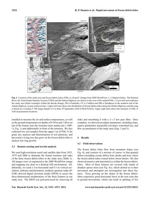
Fig. 1. Location of <strong>the</strong> study area <strong>and</strong> frozen debris-lobes (FDL) A, B <strong>and</strong> C (Image from 2008 WorldView-1, © Digital Globe). The Dietrich<br />
River, <strong>the</strong> TransAlaska Pipel<strong>in</strong>e System (TAPS) <strong>and</strong> <strong>the</strong> Dalton Highway are shown to <strong>the</strong> west of <strong>the</strong> studied FDLs. Lower left <strong>in</strong>set <strong>in</strong>dicates<br />
<strong>the</strong> study area (black rectangle) with<strong>in</strong> <strong>the</strong> Brooks Range; FB is Fairbanks, CF is Coldfoot <strong>and</strong> DH is Deadhorse at <strong>the</strong> nor<strong>the</strong>rn end of <strong>the</strong><br />
Alaska Highway system (maroon l<strong>in</strong>e). Upper left <strong>in</strong>set shows <strong>the</strong> distribution of frozen debris-lobes along <strong>the</strong> Dalton Highway <strong>and</strong> this map<br />
is based on a L<strong>and</strong>sat-5 TM image (b<strong>and</strong>s 4-3-2) from 19 September 2010 (USGS/NASA). Upper right <strong>in</strong>set shows <strong>the</strong> term<strong>in</strong>us of FDL-A<br />
with measurement locations.<br />
<strong>in</strong>stalled to measure <strong>the</strong> air <strong>and</strong> surface temperatures, as well<br />
as <strong>the</strong> ground temperatures at depths of 0.50 m <strong>and</strong> 1.80 m on<br />
top of <strong>the</strong> feature near <strong>the</strong> term<strong>in</strong>us (near marker p<strong>in</strong> 1 (MP-<br />
1); Fig. 1) <strong>and</strong> additionally <strong>in</strong> front of <strong>the</strong> term<strong>in</strong>us. We also<br />
collected two soil samples from <strong>the</strong> upper 1 m of FDL-A <strong>for</strong><br />
gra<strong>in</strong> size analysis <strong>and</strong> determ<strong>in</strong>ation of soil plasticity, <strong>and</strong><br />
harvested a liv<strong>in</strong>g tree that grew on <strong>the</strong> frozen debris-lobe to<br />
analyse tree r<strong>in</strong>g growth.<br />
3.2 Remote-sens<strong>in</strong>g <strong>and</strong> terra<strong>in</strong> analysis<br />
We used high-resolution aerial <strong>and</strong> satellite data from 1955,<br />
1979 <strong>and</strong> 2008 to del<strong>in</strong>eate <strong>the</strong> frontal term<strong>in</strong>us <strong>and</strong> sides<br />
of <strong>the</strong> three frozen debris-lobes <strong>in</strong> <strong>the</strong> study area (Table 1).<br />
All images were co-registered to <strong>the</strong> 2008 WorldView image<br />
<strong>and</strong> mapp<strong>in</strong>g was done <strong>in</strong> a desktop GIS environment. Additionally,<br />
we used a 5-m horizontal <strong>and</strong> 0.1-m vertical resolution,<br />
airborne <strong>in</strong>terferometric syn<strong>the</strong>tic aperture radar (If-<br />
SAR) derived digital elevation model (DEM) to assess <strong>the</strong><br />
three-dimensional morphometry of <strong>the</strong> three features <strong>in</strong> our<br />
study area. The DEM was post-processed by remov<strong>in</strong>g all<br />
s<strong>in</strong>ks <strong>and</strong> smooth<strong>in</strong>g it with a 3 × 3 low pass filter. Once<br />
complete, we derived secondary parameters, <strong>in</strong>clud<strong>in</strong>g <strong>slope</strong>,<br />
aspect, planimetric <strong>and</strong> profile curvature, watershed size, <strong>and</strong><br />
flow accumulation of <strong>the</strong> study area (Figs. 2 <strong>and</strong> 3).<br />
4 Results<br />
4.1 Field observations<br />
The frozen debris lobes flow from mounta<strong>in</strong> <strong>slope</strong>s (see<br />
Fig. 4), <strong>and</strong> consists of a mixture of coarse- to f<strong>in</strong>e-gra<strong>in</strong>ed<br />
debris (<strong>in</strong>clud<strong>in</strong>g woody debris from shrubs <strong>and</strong> trees where<br />
<strong>the</strong> frozen debris-lobes extend below <strong>for</strong>est limits). We also<br />
observed massive <strong>and</strong> <strong>in</strong>terstitial ice with<strong>in</strong> <strong>the</strong> frozen debrislobes.<br />
Most of <strong>the</strong>se features are covered with st<strong>and</strong>s of<br />
drunken spruce trees (see Fig. 4c), which alerted us to <strong>the</strong>ir<br />
movement <strong>and</strong> prompted our <strong>in</strong>vestigation <strong>in</strong>to <strong>the</strong>se features.<br />
Trees grow<strong>in</strong>g on <strong>the</strong> <strong>slope</strong>s of <strong>the</strong> frozen debrislobes<br />
experience great horizontal stress <strong>in</strong> <strong>the</strong> root zone due<br />
to ground movements, which can result <strong>in</strong> splitt<strong>in</strong>g of live<br />
Nat. Hazards Earth Syst. Sci., 12, 1521–1537, 2012 www.nat-hazards-earth-syst-sci.net/12/1521/2012/