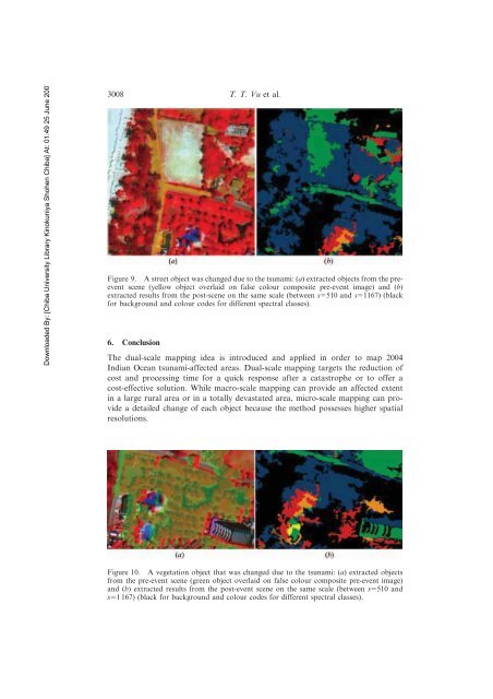
Downloaded By: [Chiba University Library Kinokuniya Shohen Chiba] At: 01:49 25 June 20073008 T. T. Vu et al.Figure 9. A street object was changed due to the <strong>tsunami</strong>: (a) extracted objects from the preeventscene (yellow object overlaid on false colour composite pre-event image) and (b)extracted results from the post-scene on the same <strong>scale</strong> (between s5510 and s51167) (black<strong>for</strong> background and colour codes <strong>for</strong> different spectral classes).6. ConclusionThe dual-<strong>scale</strong> mapping idea is introduced and applied in order to map 2004Indian Ocean <strong>tsunami</strong>-<strong>affected</strong> <strong>areas</strong>. <strong>Dual</strong>-<strong>scale</strong> mapping targets the reduction <strong>of</strong>cost and processing time <strong>for</strong> a quick response after a catastrophe or to <strong>of</strong>fer acost-effective solution. While macro-<strong>scale</strong> mapping can provide an <strong>affected</strong> extentin a large rural area or in a totally devastated area, micro-<strong>scale</strong> mapping can providea detailed change <strong>of</strong> each object because the method possesses higher spatialresolutions.Figure 10. A vegetation object that was changed due to the <strong>tsunami</strong>: (a) extracted objectsfrom the pre-event scene (green object overlaid on false colour composite pre-event image)and (b) extracted results from the post-event scene on the same <strong>scale</strong> (between s5510 ands51 167) (black <strong>for</strong> background and colour codes <strong>for</strong> different spectral classes).
Downloaded By: [Chiba University Library Kinokuniya Shohen Chiba] At: 01:49 25 June 2007Remote Sensing <strong>of</strong> Sumatra Tsunami <strong>of</strong> 26 December 2004 3009Figure 11. A vegetation object that was retained after the <strong>tsunami</strong>: (a) extracted from thepre-event scene (green object overlaid on false colour composite pre-event image) and (b)extracted from the post-event scene (green object overlaid on false colour composite posteventimage) on the same <strong>scale</strong> (between s5510 and s51 167).Several new image-processing <strong>approach</strong>es were also developed and applied inproposed dual-<strong>scale</strong> processing. These are area morphological filtering, areamorphological classification/segmentation, and pan-sharpening PCPANfit. Each<strong>of</strong> them plays a vital role in the proposed processing flow and is applicable to imageprocessing in general. For a further development <strong>of</strong> the dual-<strong>scale</strong> mapping system,a GIS-based environment would be essential allowing users to connect to web-baseddata catalogues in order to search <strong>for</strong> satellite images prior to processing. Userscould search local user databases or other agencies’ databases. The idea would alsobe applicable to mapping or monitoring other natural hazards like floods andearthquakes, etc.AcknowledgementThe QuickBird scenes used in this study are owned by DigitalGlobe Co., Ltd and theSRTM DEM was provided by the US Geological Survey (USGS).ReferencesAGOURIS, P., CARSWELL, J. and STEFANIDIS, A., 1999, An environment <strong>for</strong> content-basedimage retrieval from large spatial database. ISPRS Journal <strong>of</strong> Photogrammetry andRemote Sensing, 54, pp. 263–272.ANDRES, R.J. and ROSE, W.I., 1995, Detection <strong>of</strong> thermal anomalies at Guatemalanvolcanoes <strong>using</strong> Landsat TM images. Photogrametric Engineering and RemoteSensing, 61, pp. 775–782.BARBER, D.G., HOCHHEIM, K.P., DIXON, R., MOSSCROP, D.R. and MCMULLAN, M.J., 1996,The Role <strong>of</strong> Earth Observation Technologies in Flood Mapping: A Manitoba CaseStudy. Canadian Journal <strong>of</strong> Remote Sensing, 22, pp. 137–143.CASTELLI, V., BERGMAN, L., KONTOYIANNIS, I., LI, C.-S., ROBINSON, J. and TUREK, J., 1998,Progressive search and retrieval in large image archives. IBM Journal <strong>of</strong> Research andDevelopment, 42, pp. 253–268.EGUCHI, R.T., HUYCK, C.K., HOUSHMAND, B., MANSOURI, B., SHINOZUKA, M.,YAMAZAKI, F. and MATSUOKA, M., 2000, The Marmara earthquake: a view fromspace: the Marmara, Turkey earthquake <strong>of</strong> August 17, 1999: Reconnaissance Report.Technical Report MCEER-00-0001 (Buffalo, NY: MCEER), pp. 151–169.