1 - Section 4 Part 8 - Umgeni Water
1 - Section 4 Part 8 - Umgeni Water
1 - Section 4 Part 8 - Umgeni Water

Create successful ePaper yourself
Turn your PDF publications into a flip-book with our unique Google optimized e-Paper software.
Greater Bulwer-Donnybrook Bulk <strong>Water</strong> Supply schemeThe Sisonke District Municipality identified the towns of Bulwer and Donnybrook as well as manycommunities in the corridor between the two towns as not having a reliable water source. Althoughthere are small schemes in place in some areas these are either insufficient or problematic. Aregional bulk water supply scheme was proposed as a sustainable long-term solution for this area.The Luhane River, a tributary of the EMkhomazi River was identified as the potential water resourcefor this scheme, which could then be augmented from the Pholela River at a later stage if necessary.A detailed feasibility study has been completed of the proposed Bulwer Dam on the Luhane River.Ixopo GroundwaterThe water demands of the Ixopo system have been increasing over the last few years (<strong>Section</strong> 5.3)and as a result further groundwater resources are being investigated to augment the existing supply.An existing borehole situated in the valley adjacent to Ixopo Wastewater Works was pump tested inthe later part of 2010 and proved to have a sustainable yield of 350 kl/day. Infrastructureinvestigations are currently being undertaken in order to determine the feasibility and cost ofutilising this borehole to augment the existing water supply.4 . 4 . 7 M I D D L EI D D L E S O U T H C O A S T R E G I O NThe Middle South Coast region extends in a coastal strip from the Mkomazi River southwards to theMtwalume River (Figure 4.41). The region includes the Mzinto, Mpambanyoni, Mzumbe andMtwalume river catchments in the U80 tertiary catchment. Whilst the region contains a number ofrivers with significant runoff, no major impoundments exist in the region. The Umzinto supplysystem, which receives its water from the Umzinto WTP, includes the areas of Freeland Park,Hazelwood, Kelso, Pennington, Umzinto and Park Rynie. The Mtwalume supply system receiveswater from the Mtwalume WTP and includes the areas of Elysium, Ifafa, Mtwalume and Sezela.Afforestation and irrigation are widespread in the region.Surface <strong>Water</strong>The statistics of mean annual runoff for the catchments within the Middle South Coast region aresummarised in Table 4.45.158
Table 4.45Hydrological characteristics for the Middle South Coast Region (WR90).Region River (Catchment) Area(km 2 )Evaporation(mm)Rainfall(mm)Annual AverageNatural Runoff(million m 3 /yr)Natural Runoff(mm)MiddleCoastSouthMpambanyoni River(U80)555 1,200 895 58.9 110Mzimayi River (U80) 35 1,200 1,013 8.1 231Umzinto River (U80) 146 1,200 1,013 33.9 232Fafa River (U80) 261 1,200 939 34.8 133Mtwalume River (U80) 552 1,200 887 53.4 97Mzumbe River (U80) 641 1,200 882 55.1 102GroundwaterThe Middle South Coast Region occurs in the KwaZulu-Natal Coastal Foreland Groundwater Region(Figure 4.10).159
Figure 4.41 General layout of the Middle South Coast Region.160
Figure 4.42 Groundwater potential in the Middle South Region.161
Hydrogeological UnitsThe hydrogeologically relevant lithologies recognised in the Middle South Coast comprise ofsandstone, mudstone/ shale, tillite and granite/gneiss.GeohydrologyOn the south coast the thickness of the Natal Group Sandstone (NGS) is irregular, decreasingnorthwards from a maximum in the Eastern Cape of about 500 m, to some 200 m in Oribi Gorge.North of the Mzimkhulu River it is overstepped by the Dwyka Formation. The Dwyka is the mostextensive lithological unit in the region. It occurs in a belt from northeast of Ixopo southwards toEzingolweni. The Shales of the Pietermaritzburg Formation outcrop chiefly in the uplands aroundIxopo and extend southwards through Harding. They are extensively intruded by dolerite sills. Thecoastal regions especially prevalent in the Mtwalume catchment are the rocks of the NatalMetamorphic Province (NMP)Groundwater PotentialPrimary groundwater supplies using boreholes fitted with handpumps, wind pumps or submersiblesare obtainable in most of the lithological units. The exceptions are the Dwyka formation (tillites) ormassive granites. In these areas groundwater supply could be obtained within an adjacent faultvalley where the potential for high yielding boreholes is much enhanced.The sandstone of the Natal Group represents the most productive groundwater-bearing lithology,followed by mudstone/shale lithologies, the granite/gneiss lithologies and the tillite sediments of theDwyka Tillite Formation.Boreholes favourable located in the Natal Group Sandstone (NGS) provide good yields. Yields of 3 l/s(greater than 10 000 l/hr) are not uncommon where large scale fracturing/faulting provide conduitsfor groundwater movement (Figure 4.42).Boreholes located in metamorphic lithologies indicate yield characteristics in the range 0.1 to 0.5 l/s,with a median value of 0.3 l/sec.<strong>Water</strong> QualityThe EJ Smith system is supplied from the EJ Smith Dam which is highly impacted by the town,farming and industrial activities upstream in the catchment. High nutrient concentration, algalcounts, E. coli and turbidity as a result of sewer reticulation problems within Umzinto town.The Mtwalume WTP abstracts water directly from the Mtwalume River. Since there is noimpoundment of water, point source and rainfall related pollution will have immediate effects onthe raw water quality. The algal counts in 2010 have increased thus breaching the RQO limit.Turbidity is also a problem. This is probably caused by sand mining along the banks of the riverupstream of the treatment facility.162
Figure 4.43Percentage compliance vs. non-compliance with the Resource Quality Objectivefor the E.J. Smith – Umzinto System.163
Figure 4.44Percentage compliance vs. non-compliance with the Resource Quality Objectivefor the Mtwalume.The ambient quality of groundwater in the Middle South Coast Region is generally very good withonly 3% of the recorded electrical conductivity (EC) values exceeding a value of 450 mg/l (70 mS/m).Iron concentrations are generally higher than SANS 241 standards for drinking water, however, highiron concentrations are not detrimental to health but rather to taste.164
Existing AllocationsThe water resources with land use impacts in the Middle South Coast Region, as indicated inTable 4.46 are reported cumulatively for all the rivers. Although slightly dated (2004), these valuesprovide an indication of the state of the region.Table 4.46Surface water resources of the Middle South Coast Region at a 98% assurance(DWAF 2004).Resource CategoryAvailable/Impact(million m 3 /annum)Available/Impact(Ml/day)Gross surface water resource 25 69Subtract:• Ecological Reserve 14 38• Invasive Alien Plants 1 3• Dryland Sugar Cane 0 0Net Surface <strong>Water</strong> Resource 10 27Groundwater 1 3Return Flows 1 3Total Local Yield 12 33Transfers In 2 6Total 14 39ReserveNo comprehensive assessment of the Ecological Reserve of the Middle South Coast Region has beenundertaken to date. Estimates of the Reserve indicate that the ecological Reserve will have a largeimpact on the availability of water in the catchment.<strong>Water</strong> Balance/AvailabilityThe urban requirements include those of the towns of Pennington, Hazelwood, Umzinto, Park Rynie,Mtwalume, Ifafa, Sezela, Elysium and Hibberdene. There is a small industrial requirement(1.2 million m 3 /annum or 3.3 Ml/day) relating to the Sezela Sugar Mill which abstracts water directlyfrom a run-of-river structure on the Ifafa River. During the 2010/11 financial year, <strong>Umgeni</strong> <strong>Water</strong>registered the amount of 4.4 million m 3 /annum (12 Ml/day) with DWA for the abstractions fromboth Mzinto and E.J. Smith dams combined and 3.1 million m 3 /annum (8.5 Ml/day) was registeredfor the Mtwalume run-of-river abstraction.165
Table 4.47<strong>Water</strong> requirements/allocations and the water resources in the Middle SouthCoast Region.CategoryVolume(Million m 3 /annum)Volume(Ml/day)Available <strong>Water</strong>Local Yield 12 33Transfer In 2 6Total 14 39<strong>Water</strong> Requirements Urban 8 22 Industrial 1 3 Rural 5 14 Irrigation 4 11 Afforestation 0 0Transfers Out 0 0Total 18 50Balance -4 -11Some of the individual catchments are stressed and can not meet the domestic and industrialrequirements during the low flow periods. <strong>Part</strong> of the reason is the high summer season waterdemands due to the influx of holiday-makers to the area over this period.Existing Infrastructure and YieldsThe significant existing infrastructure in the Middle South Coast Region is the existing impoundmentsof Umzinto Dam (Table 4.48 and Figure 4.45) on the Mzinto River and the EJ Smith Dam (Table 4.49and Figure 4.46) on the Mzimayi River.166
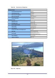
Table 4.48Characteristics of Umzinto Dam.Name of Dam:River Located on:UmzintoMzinto RiverCatchment DetailsIncremental Catchment Area: 51.6 km 2Total Catchment Area: 51.6 km 2Mean Annual Precipitation:985 mmMean Annual Runoff: 6.91 million m 3Annual Evaporation:1 200 mmDam CharacteristicsGauge Plate Zero:Full Supply Level:125.3 mASL142 mASLNet Full Supply Capacity: 0.48 million m 3Dead Storage: 0.0 million m 3Total Capacity: 0.48 million m 3Surface Area of Dam at Full Supply Level: 0.0742 km 2Dam Type:ConcreteMaterial Content of a Dam Wall: Concrete: 27 500 m 3Crest Length:Type of Spillway:Spillway <strong>Section</strong>: 52 mNon-Spillway <strong>Section</strong>: 63 mUncontrolledCapacity of Spillway: 730 m 3 /sFuture Capacity Once Dam Wall has been Raised: N/A m 3Figure 4.45Umzinto Dam.167
Table 4.49Characteristics of E.J. Smith Dam.Name of Dam:River Located on:E.J. SmithMzimayi RiverCatchment DetailsIncremental Catchment Area: 15.84 km 2Total Catchment Area: 15.84 km 2Mean Annual Precipitation:1060 mmMean Annual Runoff: 3.43 million m 3Annual Evaporation:1 240 mmDam CharacteristicsGauge Plate Zero:Full Supply Level:93.0 mASL109.1 mASLNet Full Supply Capacity: 0.979 million m 3Dead Storage: 0.0 million m 3Total Capacity: 0.979 million m 3Surface Area of Dam at Full Supply Level: 0.1766 km 2Dam Type:ConcreteMaterial Content of a Dam Wall: Concrete: 3 800 m 3Crest Length:Type of Spillway:Spillway <strong>Section</strong>: 24.4 mNon-Spillway <strong>Section</strong>: 82.6 mUncontrolledCapacity of Spillway: 220 m 3 /sFuture Capacity Once Dam Wall has been Raised: N/A m 3Figure 4.46E.J. Smith Dam.168
Table 4.50Dams in the Middle South Coast Region.ImpoundmentRiverCapacity(million m 3 )PurposeE.J. Smith Dam Mzimayi 0.98 DomesticUmzinto Dam Mzinto 0.48 DomesticTable 4.51Yield Information for the existing water resource infrastructure in the MiddleSouth Coast Region.ImpoundmentRiverCapacity(million m 3 )Yield(million m 3 /annum)Stochastic Yield(million m 3 /annum)Historical 1:50 1:100E.J. Smith Dam Mzimayi 0.980.9(2.5 Ml/day)1.3(3.6 Ml/day)1.2(3.3 Ml/day)Umzinto Dam Mzinto 0.481.6(4.4 Ml/day)2.1(5.6 Ml/day)1.9(5.2 Ml/day)Mtwalume(Run-off-River)Mtwalume - -1.7(4.7 Ml/day)1.2(3.3 Ml/day)Operating RulesThe operating rules for this region used to consider three water resource systems, viz. Mkomazi,Mzinto/Mzimayi and Mtwalume rivers as a single entity. After the commissioning of the South CoastPipeline (SCP-1), the Craigieburn WTP, which received raw water from the EMkhomazi River, wasclosed and the system from the WTP is now fed with potable water from the SCP-1 (<strong>Section</strong> 5.2).The transfer link from the WTP to the Umzinto area has not been used due to the growth ofdemands in the Craigieburn area. The transfer link from the Mtwalume River to the Umzinto area isin place but has not been used due to the growth of demands in the Mtwalume area.A schematic of the operating rule is shown in Figure 4.47.Figure 4.47Schematic of the Middle South Coast operating rule.169
The operating rule has changed over time due to the higher demands in the Middle South Coastarea. It no longer involves the Mtwalume and Mkomazi systems which were used to support theUmzinto area. DWA has commissioned a study to develop operating rules for small to medium damsin the country and these dams are part of the study. The current operating rule is as follows:• Use E.J. Smith Dam spills – lowest unit cost route of supply.• Use Umzinto Dam or Esperanza Weir spills – second lowest cost supply route.• Use more storage from Umzinto Dam than E.J. Smith Dam.• The last source to be used is E.J. Smith Dam storage.Additional water is to be provided to the Umzinto WTP from the SCP-1 in the near future(<strong>Section</strong> 5.4) to meet the growing demands in the area.Proposed <strong>Water</strong> Resource InfrastructurePotential development options that have been identified in the Middle South Coast Region are:• The abstraction efficiency at the existing Mtwalume Abstraction Works will need to beimproved as a short-term solution. At the moment it can only pump water when water in theMtwalume River exceeds an estimated flow rate of 0.2 m 3 /s;• The abstraction efficiency at the existing Umzinto Abstraction Works at the Esperanza Weircould be improved as a short-term measure because it has been estimated that an averagesystem loss of 20% occurs between the dam and the abstraction works;• The Umzinto Dam has been designed to be raised. This could possibly provide a short-termlocal solution, if the increased yield is not adversely affected by siltation and upstream landuse practices;• The Mgeni System can be linked via Phase 1 of the South Coast pipeline to the Umzinto WTPin order to augment the supply to the inland region;• A medium- to long-term solution is to link the lower Mzimkhulu water resource to the MiddleSouth Coast system; and• The long-term solution is to construct Phase 2 of the South Coast Bulk Pipeline (SCP-2) toextend the bulk water supply south from Park Rynie to Hibberdene (<strong>Section</strong> 5.4).Simultaneously, a regional abstraction and WTP facility will need to be constructed on thelower EMkhomazi River (<strong>Section</strong> 5.4) to provide the necessary sustainable water resources.The SCP-2 would link into the Lower South Coast system being supplied from the MzimkhuluRiver to provide flexibility.Mhlabatshane Bulk <strong>Water</strong> Supply SchemeThe Mhlabatshane River BWS Scheme will supply water to the communities within theUmzumbe Municipality, and the Hibiscus Coast Municipality. The scheme includes the constructionof a dam on the Mhlabatshane River, a tributary of the Umzumbe River to provide the necessarywater resources, which will supply raw water to a new WTP in the area. It is estimated that theavailable water resources for the scheme is 2.4 million m 3 /annum after accounting for all streamflow reduction activities including the reserve (Stemele Bosch and Associates 2007).170