DDS-606 - Prince George's County Planning Department
DDS-606 - Prince George's County Planning Department
DDS-606 - Prince George's County Planning Department

You also want an ePaper? Increase the reach of your titles
YUMPU automatically turns print PDFs into web optimized ePapers that Google loves.
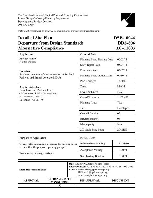
The Maryland-National Capital Park and <strong>Planning</strong> Commission<strong>Prince</strong> George’s <strong>County</strong> <strong>Planning</strong> <strong>Department</strong>Development Review Division301-952-3530Note: Staff reports can be accessed at www.mncppc.org/pgco/planning/plan.htm.Detailed Site PlanDeparture from Design StandardsAlternative ComplianceApplicationProject Name:Naylor StationGeneral DataDSP-10044<strong>DDS</strong>-<strong>606</strong>AC-11003<strong>Planning</strong> Board Hearing Date: 06/02/11Staff Report Date: 05/24/11Location:Southeast quadrant of the intersection of SuitlandParkway and Branch Avenue (MD 5).Applicant/Address:Branch Avenue Partners LLCc/o Ironwood Realty Management507 Fortress CircleLeesburg, VA 20175Date Accepted: 03/07/11<strong>Planning</strong> Board Action Limit: 05/16/11Plan Acreage: 14.8012Zone:M-X-TDwelling Units:N/AGross Floor Area: 1,162,000<strong>Planning</strong> Area:76ATier:DevelopedCouncil District: 07Election District 06Municipality:200-Scale Base Map:N/A204SE03Purpose of ApplicationOffice, retail uses, and a departure for parking spacesizes within the proposed parking garage.Tree canopy coverage variance.Notice DatesInformational Mailing: 12/28/10Acceptance Mailing: 03/04/11Sign Posting Deadline: 05/03/11Staff RecommendationAPPROVALStaff Reviewer: Zhang / Kosack / FritzPhone Number: 301-952-4151 / 301-952-4689 / 301-952-5402E-mail: Henry.Zhang@ppd.mncppc.orgJill.Kosack@ppd.mncppc.orgKate. Fritz@ppd.mncppc.orgAPPROVAL WITHDISAPPROVAL DISCUSSIONCONDITIONSX
constitutes the first phase of the previously approved Conceptual Site Plan, CSP-10005, for thesite. Conceptual Site Plan CSP-10005 was approved for a two-phase development.2. Development Data Summary:EXISTINGPROPOSEDZone(s) M-X-T M-X-TUse(s)Commercial IntegratedShopping CenterOffice/RetailAcreage 14.8 14.8Parcels 7 8Gross Floor Area of Retail Uses (sq. ft) 128,130 12,000Gross Floor Area of Office Uses (sq. ft) - 1,150,000Total Gross Floor Area (sq. ft) 128,130 1,162,000TREE CANOPY COVERAGEVariance (30%) from the tree canopycoverage requirements in Subtitle 25,Section 25-128.RequiredProposed64,474 sq. ft. 44,625 sq. ft.OTHER DEVELOPMENT DATAREQUIREDPROPOSEDTotal Parking Spaces + 1,630of which are Parking garage spaces - 1,500Surface Parking spaces - 130Handicapped regular spaces 27* 16Van accessible spaces - 11┼Total Loading spaces + 7of which are Office - 6Retail - 1Notes: +The Zoning Ordinance does not have specific off-street parking and loading numbers fordevelopment in the M-X-T Zone. Instead, Section 27-574 and Section 27-583 of the ZoningOrdinance establish procedures for calculating the number of off-street parking and loadingspaces, respectively. See Finding 8 below for a discussion of parking and loading requirements inthe M-X-T Zone.┼Includes two surface van-accessible handicapped spaces and nine van-accessible handicappedspaces in the parking garage.*The number of parking spaces for the physically handicapped is calculated in accordance withSection 27-566 of the Zoning Ordinance based on the total number of proposed parking spaces.2 DSP-10044, <strong>DDS</strong>-<strong>606</strong> & AC-11003
3. Location: The site is located on the northeast side of Branch Avenue (MD 5) and in the southeastquadrant of the intersection of Suitland Parkway and Branch Avenue. The property is located in<strong>Planning</strong> Area 76A, Council District 7, within the Developed Tier.4. Surrounding Uses: The subject property is currently developed with a multi-part masonryshopping center, with a total of approximately 128,130 square feet of enclosed space andassociated surface parking lots. The shopping center was developed in phases from 1954 to 1969.To the southwest of the larger site is the variable width right-of-way of Branch Avenue (MD 5),an arterial roadway. Also, along the southwest edge, the site wraps around two separate parcelswith frontage on Branch Avenue that are zoned M-X-T and developed with small, single-story,retail buildings. To the southwest, across Branch Avenue, is the Naylor Road Metro Station, onthe Green Line, its associated parking and various commercially-developed, M-X-T-zonedproperties. The Branch Avenue entrance to the Naylor Road Metro Station is located directlyacross Branch Avenue from the northernmost existing entrance to the subject property. To thenorth of the subject property is the Washington Metropolitan Area Transit Authority’s (WMATA)above-ground Green Line metro tracks and the right-of-way of the Suitland Parkway. To thenortheast, the subject property abuts a parcel zoned Multifamily Medium Density Residential(R-18) developed with a multifamily garden apartment complex, Carriage Hill Apartments,beyond which is the Suitland Parkway right-of-way. To the southeast of the larger site are aparcel zoned Open Space (O-S) developed with an elementary school known as OverlookElementary School, which fronts on and is served from Curtis Drive; a vacant M-X-T-zonedparcel; and an M-X-T-zoned parcel developed with a liquor store that fronts on Branch Avenue.The portion of the site included in this DSP is located at the intersection of Branch Avenue andSuitland Parkway, which is referred to as Phase 1 in previously approved CSP-10005. Most ofPhase 1, except the seven-story parking garage at the rear of the site, is separated from Phase 2 bythe main driveway to the site from the Branch Avenue entrance. Across the driveway to thenortheast is the site for the Phase 2 development.5. Previous Approvals: On September 23, 2008, the District Council rezoned the subject propertyto the M-X-T Zone by the adoption of the 2008 Approved Branch Avenue Corridor Sector Planand Sectional Map Amendment. On May 12, 2011, the <strong>Planning</strong> Board approved Conceptual SitePlan CSP-10005 (PGCPB Resolution No. 11-44 will be adopted on May 26, 2011) covering theentire site for a mixed-use development consisting of 1,600,000 square feet of office space and upto 32,000 square feet of retail uses with associated parking. A Preliminary Plan of Subdivision,4-11001, proposing to subdivide the entire site into eight parcels, has been scheduled for ahearing on the <strong>Planning</strong> Board agenda of May 26, 2011. The site also has an approvedStormwater Management Concept Plan, 8888-2010-00, which is valid through April 10, 2013.6. Design Features: The detailed site plan, which covers the entire site, proposes to develop theportion identified as Phase 1 of the CSP with a mixed-use project consisting of approximately1.15 million square feet of office, with a seven-story parking garage, and 12,000 square feet ofretail uses. The Phase 2 portion of the site, as referred to in the CSP, has been identified as a sitefor future development.The subject site is located at the northwestern tip of the Branch Avenue Corridor Sector Plan areaand also the gateway area from the District of Columbia to <strong>Prince</strong> George’s <strong>County</strong>. Theproposed development is also the first large-scale redevelopment within the entire Branch AvenueCorridor. Therefore, creation of a strong gateway image and establishment of high redevelopmentstandards for the entire corridor has been the focus of this DSP application.3 DSP-10044, <strong>DDS</strong>-<strong>606</strong> & AC-11003
Four access points have been proposed off Branch Avenue (MD 5). A full access entrance alongwith the main driveway leading to the service court, which is located in the rear middle part of thesite, divides the site into two distinct parts. The northern part adjacent to the Suitland Parkway isPhase 1, which is covered in this DSP and will be developed with a six- to nine-story officecomplex with approximately 1.15 million square feet of gross floor area. The office complex hasa proposed main entrance/main lobby area located close to the build-to line of Branch Avenuewhich is accessed from the street level. Visitors will finish security clearance in the lobby areaand take escalators to the upper level, through an atrium, in order to reach the office area of thebuilding. This entrance is also linked to WMATA’s property by crosswalks across BranchAvenue and further through pedestrian paths to the Naylor Road Metro Station on the Green Line.The rest of the building is set back more than 180 feet from the existing curb line in order tosatisfy the security requirements of a potential federal tenant. Between the office building and thecurb line of Branch Avenue, there are a proposed retail building, sitting area, plaza area, andbioretention areas. A low masonry wall, which is 50 feet away from the office building, definesthe security perimeter for the proposed office complex. Two additional access points are locatedin the northern section. The northernmost access point is for emergency vehicles only, shown as aright-in/right-out entrance. The one between the emergency access and the main access point tothe site is a right-in-only entrance drive. A future vehicle drop-off bay has been shown close tothe building’s main entrance. A bus stop is located on the other side of Branch Avenue (MD 5).The southern part of the site has been designated primarily for the second phase of the proposeddevelopment in accordance with CSP-10005, except for the rear portion where a seven-storyparking structure is located. The parking garage is linked to the office complex by a pedestrianbridge. The rest of the southern part of the site has been identified as the location for futuredevelopment. The fourth access to the site is located adjacent to the southernmost boundary line,runs along the southeastern edge of the property, connects to the parking garage, and providesaccess to both the future parking garage and the office building in the second phase.In addition to renderings of the proposed buildings, architectural elevation views have beenprovided to show the style and quality of the proposed buildings, as well as other on-siteimprovements. The office complex elevations and renderings feature a wedge-shaped, modernstructure attached to an outer curved façade facing Suitland Parkway that matches the curvatureof Suitland Parkway’s right-of-way along the site. The outer section of the wedge is nine storieshigh and the central section of the wedge steps down to six stories in height. The nine-storysection of the building fronts on Suitland Parkway and the six-story section has an atrium and ismore prominently viewed from Branch Avenue (MD 5). A green roof has been proposed on theperimeter of the six-story section that flanks the central atrium. An additional green roof has beenshown on the top of the retail building facing Branch Avenue.The office building is designed in modern institutional building vocabulary with variousfenestration patterns. The building is finished with architectural grade, sand-blasted, light colormasonry blocks in combination with glass. Additional dark-toned bands, in a similar color alongthe window line, have been used to embellish the façade and provide visual interest. Acombination of primarily punched openings and a small portion of ribbon widows has beenshown on the elevations. The ribbon windows are used on the two corner portions of theelevations of the nine-story part of the building where curved lines meet straight lines. Someribbon windows are also shown on the six-story part, especially the elevation oriented towardBranch Avenue. An elevated base portion has been shown on the elevations. The main entranceto the office building is designed in an all-glass, two-story structure as a natural extension of thelarge office building. The location of the main entrance close to the build-to line of BranchAvenue and its transparent glass design make the entrance a visually prominent part of the site’s4 DSP-10044, <strong>DDS</strong>-<strong>606</strong> & AC-11003
Branch Avenue frontage. A marked sidewalk leading to the entrance connects the office buildingto the WMATA Naylor Road Station across the street, approximately 600 feet away.The parking garage serving the office complex is a typical, seven-story, boxy garage buildingwith plain concrete finishing. Since the parking garage backs to the existing apartment complexknown as Carriage Hill to the northeast of the subject site, additional building decoration orscreening will be needed in order to minimize the visual and possible noise impacts on theapartment buildings. At full build-out of the site, two buildings will be located between theparking garage and the site’s frontage of Branch Avenue (MD 5). Therefore, the parking garagewill not be visible from Branch Avenue. The parking garage has been set back 30 feet from theproperty line due to the Section 4.7 bufferyard building setback requirements of the <strong>Prince</strong>George’s <strong>County</strong> Landscape Manual. A 20-foot-wide landscape strip is required to be installedwith 80 plant units per 100 linear feet of property line. However, given the height of the garageand in order to break the sterile appearance of the concrete structure, additional elevationtreatments should be provided. The possible solutions included changing the pattern of theopenings to a more punched-out style instead of the proposed ribbon-style wide openings, orproviding green screen, especially for the upper levels to soften the hard surface of the building,or a combination of either methods, or other equivalent design solutions. At full build-out, thegarage will not be visible from Branch Avenue. Since Phase 2 will not be put in place right away,the appearance of the parking garage after the completion of the first phase is a concern of thestaff. A condition has been proposed to require the applicant to provide additional elevationtreatments on the parking garage facing the existing multifamily development site and the interimelevation that is visible from Branch Avenue (MD 5) before the second phase, to be reviewed bythe Urban Design Section as the designee of the <strong>Planning</strong> Board prior to the issuance of buildingpermits.The retail building proposed in this application is a five-bay structure located along the build-toline of Branch Avenue (MD 5). The building has a two-story appearance with a functionalone-story floor plan to meet the intent of the sector plan to create an active store frontage alongBranch Avenue and a continuous street wall in proportion to the width of the right-of-way. Theelevation is finished with brick with precast trim and storefront glazing. Due to securityconsiderations for a potential federal tenant, the retail building is designed as a stand-alonebuilding outside of the security wall. A wide driveway and surface parking are located betweenthe retail building and the office building. An optional retail building location (Option B), whichis set back about 62 feet from the build-to line and is outside of the easement of the MarylandState Highway Administration (SHA), has been included in this DSP.The retail building, in the current location as shown in the DSP, is sited over an easement ownedby the SHA to meet the build-to line requirement of the sector plan. The applicant intends topurchase the easement and SHA is in a position to sell it because enough space has beenpreserved within the right-of-way of Branch Avenue (MD 5). However, the process of selling thepublic easement is lengthy and time consuming. The applicant may not be able to obtain theeasement rights in a timely fashion in order to move the project forward. For this reason, theapplicant proposes an alternative option (Option B), which moves the retail building outside ofthe easement and 20 feet closer to the office building, and results in one row of surface parkingbeing located in front of the retail building. An additional low masonry wall matching thebuilding in color, material, and landscaping, as suggested in the CSP approval, has been providedto screen the cars and meet the intent of the sector plan regarding the Branch Avenue frontage.The Urban Design Section encourages the applicant to work closely and diligently with SHA toobtain the easement rights, so that the retail building will be able to be located at the build-to lineas shown. A condition has been proposed requiring that, at the time of issuance of building5 DSP-10044, <strong>DDS</strong>-<strong>606</strong> & AC-11003
permits, if the applicant has not purchased the easement from SHA, Option B should be used asthe basis for the permit to guide development of the retail building following revision of the DSPby the Urban Design staff as designee of the <strong>Planning</strong> Board, to formally replace Option A withOption B.A key map on the elevation drawings will help identify each elevation for all buildings. Acondition to require such a key map to be added to the elevation drawings prior to certificationhas been included in the Recommendation section of this report.Three monumental entrance signs have been proposed in the DSP. The two larger sign faces aremeasured at 20 square feet each and the smaller sign face is measured at 16 square feet. Theheight of all three signs is lower than six feet. Both the sign face area and height are consistentwith the sign design standards approved in the CSP for the site. In addition, building-mountedsigns have been proposed for both the office and retail buildings. Each storefront has one primaryidentification sign which is located below the bottom of the second floor windows. Banner signsare also shown on both ends of the retail building. Since no tenant has been identified at the timeof this DSP review, details regarding building-mounted signs for the retailers are not available.Prior to the issuance of sign permits for the retail building, a <strong>Planning</strong> Director level reviewshould be required to ensure that the proposed signage is appropriate in relationship to the retailbuilding in terms of design, color, materials, and method of lighting.7. Green Buildings—LEED Certification: The U.S. Green Building Council (USGBC) is a501(c)(3) nonprofit that promotes the design and construction of environmentally, economically,and socially conscious buildings. Founded in 1993, their Leadership in Energy andEnvironmental Design (LEED) green building certification system is the premier rating systemfor green buildings and has helped to transform the way buildings are viewed from anoperational, functional, and location standpoint. In the United States, the current stock ofbuildings is responsible for 39 percent of total carbon dioxide (CO 2 ) emissions, 40 percent ofenergy usage, and 13 percent of water usage. By promoting building development in a moresustainable manner, considering social, economic, and environmental impacts, green buildingshave the potential to add $554 billion to the U.S. gross domestic product between 2009 and 2013.In 2009, President Barack Obama issued Executive Order 13514 which requires all federalagencies to submit a “Strategic Sustainability Performance Plan.” The <strong>Department</strong> of HomelandSecurity (DHS) has such a plan, and has a goal of zero-net energy by 2020 and follows the“Guiding Principles for Federal Leadership in High Performance and Sustainable Buildings(December 2008)” issued by the federal government. As a signatory to this federal memorandumof understanding (MOU), DHS is committed to planning, acquiring, siting, designing, building,operating, and maintaining high performance and sustainable buildings. The proposal for theNaylor Station location fits with this commitment.The Naylor Station project is seeking LEED certification under the Commercial Interiors andCore and Shell rating systems because DHS solicitation for offers (SFO) requires these twocertifications in proposals.6 DSP-10044, <strong>DDS</strong>-<strong>606</strong> & AC-11003
The Core and Shell development rating system is utilized when a new core and shell of a buildingare being proposed. This system covers building elements such as, building envelope, structure,and the heating, ventilating, and air conditioning (HVAC) system. Under this system, developerscontrol the design and construction of the entire core and shell base building (plumbing,mechanical, and fire protection systems). This system is mostly utilized when the tenants leasingspace in the building are not known. The Core and Shell rating system is a complement to theother rating system proposed for Naylor Station, the Commercial Interiors rating system.The Commercial Interior rating system is utilized to certify the high-performance green interiorof buildings. These interiors help promote healthy and productive work spaces, cost less tooperate and maintain, and help reduce the environmental footprint of the tenant utilizing thespace. This rating system is most often used in offices, restaurants, healthcare, hotels/resorts, andeducation buildings of all sizes. As previously mentioned, the Commercial Interior rating systemintegrates well with the Core and Shell development rating system to create a holistic approach togreen building design, construction, and operation.The two different rating systems address seven topic areas, including: Sustainable Sites, WaterEfficiency, Energy and Atmosphere, Materials and Resources, Indoor Environmental Quality,Innovation and Design, and Regional Priority credits. The Naylor Station project seeks to achievevarious credit levels in each of these categories, and is explained in depth below. The creditcategory is listed, then USGBC’s intent, and the project’s proposal.a. Sustainable SitesUSGBC intent: The location of a project is the foundation for the sustainability ofindividual buildings or an entire neighborhood. Important aspects of sustainable sitesinclude: transportation, site selection, site design and management, and stormwatermanagement. The most sustainable sites are locations that reduce transportation demand,restore degraded or contaminated areas, minimize impacts such as light pollution, andmanage stormwater to protect water quality and nearby streams.Naylor Station Project strategy: Due to the proximity to the Naylor Road Metro station,this site can potentially earn many sustainable sites credits. The project proposes toinclude bicycle storage in the parking garage, along with designating preferred parkingfor fuel-efficient vehicles (FEV) and high-occupancy vehicles (HOV) utilized for car andvan pooling. There are also several bus lines that service this area. Another significantfulfillment of these credits will be the installation of green roof on both office and retailbuildings. This strategy helps achieve two different objectives: filter and store stormwaterand help cool the building during hot summer months.b. Water EfficiencyUSGBC intent: The Water Efficiency credits aim to better utilize the limited publicwater supply as demand increases through development pressures. The LEED systememphasizes the use of water efficiency measures that help to reduce the amount ofpotable water used by buildings, while still meeting the needs of the building’s systemsand its occupants. Measures that help achieve this goal include: indoor water forrestrooms, outdoor water for landscaping, and process water for industrial processes andbuilding mechanical systems.7 DSP-10044, <strong>DDS</strong>-<strong>606</strong> & AC-11003
Naylor Station Project strategy: The Naylor Station project proposes to utilizehigh-efficiency landscape irrigation through a greywater rainwater capture method. Thiswill reduce the pressure on potable water for the use of landscape irrigation. All of theplumbing fixtures for the project are high performance and low maintenance, helpingreduce the amount of potable water utilized in restroom facilities. Application of thesestrategies in this project anticipates at least 30 percent greater efficiency than the baselineor code requirements.c. Energy and AtmosphereUSGBC intent: The LEED rating system emphasizes the reduction of energy usage as acritical piece to the implementation of green buildings. Conventional building approachesput an unsustainable demand on the energy supply, which can have serious impacts onthe cost of operating buildings and the local power supply. Well-designed buildings andland use are shown to provide some of the most cost-effective opportunities to savemoney while reducing greenhouse gas emissions into the atmosphere. The Energy andAtmosphere credit category looks at the following four interconnected elements: energydemand, energy efficiency, renewable energy, and ongoing energy performance.Naylor Station Project strategy: This project proposes to reduce energy costs and,therefore, carbon dioxide emissions through various innovative strategies, both high andlow-tech. The energy management strategies proposed are the focal point of the goals ofthis green building. The building is being sited to optimize its orientation to maximize thethermal envelope of the building. This means that the building is oriented on an east-westaxis, maximizing the solar heat gain on the south side in the winter, while minimizing itin the summer (and utilizing shading to help).The project also proposes various daylight strategies to minimize the power requirementfor indoor lighting. The use of solar sensors on light fixtures, architectural shadingdevices, light shelves, and maximum ceiling heights will also help achieve this credit’sintent. Each user will have the ability to customize high efficiency task lights at theirindividual workstations to suit their needs. Recognizing the type of work to be done inthis building, the project proposes to design a comprehensive energy management planthat will look to include sharing equipment with multi-function devices and printers.Energy Star office equipment will be purchased to help reduce the demand for energyin the Naylor Station building.One of the largest areas of energy and cost savings is from the HVAC solutions. Thesesystems will be equipped with energy efficient components and environmentally-friendlyproducts. These products include high efficiency boilers, energy recovery ventilationunits, and high efficiency centrifugal water-cooled chillers with chlorofluorocarbon-freerefrigerant and nontoxic water treatment chemicals for the hydraulic systems. Anotherarea of savings will be through the optimization of chiller configuration and sequencingthrough the building automation system (BAS).The last strategy of achieving credits under the Energy and Atmosphere category dealswith the proposed on-site renewable energy systems. The project proposes to generate atleast one percent of the building’s energy use through the employment of on-sitephotovoltaic (PV) panels. The solar panels are proposed to be installed on the garage.8 DSP-10044, <strong>DDS</strong>-<strong>606</strong> & AC-11003
d. Materials and Resources:USGBC intent: This credit category seeks to reduce the amount of waste generated bybuildings throughout their lifecycle, from construction to building operation anddemolition. The Materials and Resources category encourages strategies that look toreduce material and resource usage over the long-term, from a building’s life-cycleperspective. This category looks at two types of problems related to materials andresources: waste management and life-cycle impacts.Naylor Station Project strategy: DHS’s solicitation for offers (SFO) expresses aninterest in the use of regional materials, in addition to recycled content and ForestStewardship Council (FSC) certified wood products. The project will also be looking atdiverting over 75 percent of construction debris from landfills. Exact implementationstrategies will be further explored if the Naylor Station project is awarded by DHS.e. Indoor Environmental QualityUSGBC intent: The intent of this credit category is to create strategies to improve indoorenvironmental quality in order to enhance the lives of building occupants, increase theresale value of the building, and reduce the liability for the building owner. Poor indoorenvironmental conditions and pollutant concentrations can be higher indoors compared tooutdoors, and therefore, this is a major concern for building occupants. The IndoorEnvironmental Quality credit category seeks to prevent problems rather than incur therisk and expense of dealing with any illnesses and loss of productivity stemming frompoor indoor air quality. To meet the intent of this goal, this category requires the projectteam to look into issues such as indoor air quality and thermal comfort, lighting, andacoustics.Naylor Station Project strategy: Healthy indoor air quality helps create a safe andproductive work environment for employees. Various strategies to achieve this goalinclude proper ventilation and material selection at the time of construction. Otherstrategies pursued by this project include filtering airborne dust throughout the building,and making sure to change those filters prior to occupancy. There will also be a limit seton the use of volatile organic compounds (VOC) of finish on materials (like paint andpressboard), to minimize off-gassing that will occur throughout the building.f. Innovation and DesignUSGBC intent: This credit category was created in order to encourage projects to goabove and beyond credit requirements and implement innovative green buildingstrategies. The two areas to be considered for achieving the Innovation and Design goalare exceptional performance and innovation. Each project team can decide how they willgo about achieving these goals. Generally, project teams will seek to identify credits thatcan be double or achieve the next incremental threshold.Naylor Station intent: This project intends to achieve points in the Innovation andDesign category through various methods. They are looking to achieve exemplaryperformance in the Materials and Resources category, introduce a Green Housekeepingprogram, and provide for low-mercury lamping throughout the building. The project willalso gain one point for this category by having a LEED accredited professional work onthe project.9 DSP-10044, <strong>DDS</strong>-<strong>606</strong> & AC-11003
design guidelines have been used in the review of the DSP, specifically those related to buildingdesign, site design, and parking ratio since the site is located within a quarter mile of the NaylorRoad Metro Station. Technically, strict compliance with each design guideline is not required inorder to fulfill the criteria for approval of a detailed site plan. Nonetheless, the proposed detailedsite plan, including the proposed building, is in general conformance with all applicable designguidelines. The discussion of those guidelines in each section of the sector plan that are pertinentto the review of this DSP is provided as follows for informational purposes.Strategies1. Site Design1.1 Orient building frontages to face the street, courtyard, or plaza. Thestreet-facing buildings should establish a street wall deep enough from thestreet curb to provide on-street parking and wide pedestrian walkways infront of the buildings. This will create and define public spaces andencourage an active street environment.Comment: The Phase 1 development included in this DSP contains two buildings, oneoffice complex and one retail building. Both buildings are oriented toward the frontage ofBranch Avenue (MD 5). The retail building is located on the build-to line that establishesa street wall in accordance with the sector plan. Due to security requirements for apossible federal tenant, the office building is sited further away from Branch Avenue thanis the retail building. However, the main entrance to the office building has beenprojected as close as possible to the Branch Avenue frontage in order to facilitatepedestrian movement from the building to the Naylor Road Metro station. An additionalpublic plaza has been introduced between the office building and the retail building. Acombination of different building locations and use of a public plaza creates and definespublic spaces and encourages an active street environment.Staff has concerns about the design and materials used in this important plaza. Thecurrent scheme shows several segments of lower retaining walls in the middle of soddedlawn. The retaining walls also provide a seating function which would allow visitors tosit on top of them. An eight-foot-wide concrete sidewalk has been shown to travelthrough the low walls and lawn to connect to the sidewalks in front of the main entrance.Additional concrete steps have been shown close to the office side. Given its importantlocation, this public space should be designed as a real public plaza that provides atransition space between the office building and the retail building. Additional specialpavers along with more elaborate and richer materials, such as marble, should be used forthe lower retaining wall/sitting area, and artwork should also be added. The gradingshown on the site plan should also be evaluated to eliminate or minimize the steps. Anysteps that remain should be replaced with high-quality materials. A similar design andmaterial selection should be provided for the plaza area in front of the office building.Redesign of the two public plazas may be completed prior to issuance of the buildingpermit. A condition to this effect has been included in the Recommendation section. Itrequires the applicant to revise the design and material selection of the two plaza areas(one in front of the building’s main entrance area, the other one between the officebuilding and retail building) to include public artwork among other public plaza elementsincluding, but not limited to, water fountains and specialty landscaping in the designschemes of the two plaza areas, to be reviewed and approved by the Urban DesignSection as the designee of the <strong>Planning</strong> Board prior to issuance of the building permit.11 DSP-10044, <strong>DDS</strong>-<strong>606</strong> & AC-11003
1.2 Design and treat buildings at corner lots as having street frontage on bothsides governed by the relevant street guidelines.Comment: The site is located at the intersection of Branch Avenue (MD 5) and SuitlandParkway. Since the width of the right-of-way of Suitland Parkway is about 300 feet, thesite plan orients toward Branch Avenue by following sector plan streetscape guidelines.There are no streetscape guidelines for Suitland Parkway in the sector plan.1.3 Place parking at the rear or side of all buildings; avoid a direct view ofparking lots from the street. Provide parking islands with landscaping tosoften the view of asphalt pavement and to avoid the prospect of a sea ofparked cars.Comment: The majority of parking proposed for this DSP will be located within aseven-story garage in the rear of the subject site. Parking for the retail building is surfaceparking spaces which are located behind the building. Additional interim surface parkingwill be located in front of the parking garage on a portion of the second phase site, butwill be screened by the retail building from views from Branch Avenue (MD 5).1.4 Provide low screen walls or hedges, or both, at those places where surfaceparking can be viewed from the street.Comment: The proposed retail building is currently sitting on an easement owned bySHA. At the time of CSP approval, the <strong>Planning</strong> Board approved an alternative sitelayout for the building in case the easement issue could not be resolved in a timelyfashion. In the alternative layout, the building is located behind a small surface parkinglot. A combination of low masonry walls and landscaping has been used to screen theparking from views from Branch Avenue (MD 5). However, on the DSP of the alternatelayout, a drop-off area is still on the plan. Since the surface parking area has beenprovided in the alternate layout, there is no need to preserve the drop-off area in thealternate layout. As stated previously, at time of CSP approval, the current layout for theretail building is preferred by both the applicant and the <strong>Planning</strong> Board. The applicantshould make every effort to make the current layout a reality.1.5 As a pedestrian safety and beautification measure, provide a minimumfive-foot-wide landscape strip-with street trees where possible-between thecurb and sidewalk along Silver Hill Road and St. Barnabas Road.Comment: This guideline is not applicable to this site which fronts on Branch Avenue(MD 5).1.6 Incorporate wide landscape strips with trees and sidewalks-referred to as alinear park-on both sides of Branch Avenue. This provides a park-likesetting that serves as an open space with pedestrian amenities, as anenvironmental asset that captures and filters run-off, and as a barrierbetween through traffic and commercial, as well as residential activities.Comment: A minimum 20-foot sidewalk space has been preserved for the site frontagealong Branch Avenue (MD 5) in order to implement the linear park concept. The site planmeets this design guideline.12 DSP-10044, <strong>DDS</strong>-<strong>606</strong> & AC-11003
1.7 Use landscaping to beautify the street and public spaces, to bufferincompatible uses, and to screen unsightly views. Locate loading area awayfrom public views. Where this is not feasible, these areas should be properlyscreened. If surface parking is needed, it should be screened with a low wallof the same material as the building it serves, accented with plants andflowers.Comment: Landscaping has been used extensively to beautify the streetscape along thesite’s Branch Avenue (MD 5) frontage. A combination of street trees in landscaped stripsand in the tree wells, along with plazas and street furniture, has been provided in thepublic spaces. The proposed loading spaces are located in the service court that is locatedin the rear, less visible area, of the site between the proposed parking garage and officebuilding complex.1.8 Provide structured parking within the mixed-used area where appropriate,especially at the Naylor Road Metro Station and the Iverson-MarlowHeights Mixed-Use Center, using the following reduced parking (Table 7)ratios to encourage transit ridership and less dependence on automobile.Comment: A total of 1,630 parking spaces has been proposed for this DSP. In theparking garage located in the rear of the subject site, 1,525 parking spaces are proposedto be located. The parking ratio used in the DSP is 1.404 per 1,000 square feet for theoffice space and 1.25 per 1,000 square feet for the retail space. Both parking ratios arelower than the recommended 1.6 per 1,000 square feet if the site is located within aquarter mile of the Naylor Road Metro station. The DSP is consistent with the guidelineregarding parking.2. Circulation2.1 Design all new streets on a grid or curvilinear street pattern to increaseconnectivity and accessibility.Comment: The DSP contains a single 14.8-acre site. Only two main driveways lead tothe site from Branch Avenue (MD 5). A connecting driveway has been shown betweenthe two main driveways.2.2 Seek opportunities to consolidate vehicular entryways along Branch Avenueand St. Barnabas Road to encourage shared driveways and to minimize curbcuts. This will promote pedestrian safety and improve flow of vehiculartraffic.Comment: The subject site has more than 1,200 feet of frontage along Branch Avenue(MD 5). Four access points off Branch Avenue were approved at the time of CSP. One isan emergency access that will be closed most of the time. Of the three regular entrywaysalong Branch Avenue, only two are full entrances with traffic in both directions. Theaccess points proposed in this DSP are the minimally functional ones needed to serve theproposed development.2.3 Provide a minimum six-foot wide sidewalk with decorative pavers alongcommercial streets.13 DSP-10044, <strong>DDS</strong>-<strong>606</strong> & AC-11003
Comment: A minimum 20-foot-wide sidewalk has been provided in front of the retailbuilding in accordance with the streetscape guidelines of the sector plan. A widersidewalk has also been provided in front of the office complex.2.4 Provide human-scale, pedestrian-oriented frontages with retail and/oroffice spaces at the ground-floor level in designated areas.2.5 Provide wide storefront walkways along retail frontage, with pedestrianamenities such as benches, trash receptacles, bike racks and bus shelters toencourage window shopping and outdoor cafes. Encourage on-streetparking where appropriate on Branch Avenue, Old Silver Hill Road, and oninterior streets within the Naylor Road Metro Station Core area and theIverson-Marlow Heights mixed-use center. This on-street parking will act asa safety barrier between storefront walkways or sidewalks and throughstreets.Comment: The DSP satisfies the above design guidelines for the proposed retailbuilding. The retail building is designed as a human-scale, pedestrian-oriented storefrontwith open glass. In front of the storefronts, there is a minimum 20-foot-wide sidewalkwith amenities, in accordance with the requirements of the sector plan, which willprovide enough open space to encourage window shopping and a main streetenvironment for pedestrians to relax and enjoy.3. Building Design3.1 Design all buildings with high-quality materials and treatments. Exteriorbuilding walls should be constructed with brick, stone, precast concrete andother high-quality compatible materials. Reflective and tinted glass shouldnot be used on the ground floor of any buildings, and ribbons or bands ofglass should not be used for windows.Comment: The two buildings included in this DSP are finished with a combination ofarchitectural grade masonry blocks, bricks with precast trims, and metal panels alongwith various types of glazing that are of high quality. The office building employsvarious fenestration patterns including punched out openings of various sizes along witha small area of ribbon windows to provide visual variation. The combination of varioustypes of windows is needed in order to create a landmark at this prominent location. Forthe retail building, a large glass window storefront system has been used on both floors,even though only one floor is functional. The building has a two-story appearance inorder to create a proportional street wall along the site’s Branch Avenue (MD 5) frontage.The garage building located in the rear of the subject site is finished with plain concreteand designed in a typical garage form. At full built-out, the garage will not be visiblefrom Branch Avenue. However, staff has concerns about the appearance of the garagebefore the second phase development materializes. In addition, the garage elevation thatis oriented toward the existing multifamily complex to the northeast should also betreated to improve its appearance by using either additional masonry materials that matchthe building or green screens, or a combination of various strategies. A condition hasbeen included in the Recommendation section to require the applicant to improve theappearance of the exterior garage elevations.14 DSP-10044, <strong>DDS</strong>-<strong>606</strong> & AC-11003
3.2 Provide architectural elements and proportion that relate to a pedestrianscale in building façades. Large expanses of identical building walls shouldbe avoided. Façades that provide a regular and frequent pattern ofarchitectural variety through modulation of wall plane, detailing, color,texture, material, and the incorporation of art and ornament areencouraged. Ground floors facing streets or public square should be builtwith 10-to 15-foot ceiling heights to accommodate retail uses.Comment: This guideline has been implemented in the design of the two buildings. Forthe retail building, creating an active storefront with a pedestrian scale and apedestrian-friendly environment has been the design focus. The materials and colors ofthe retail building will match those of the office complex. The ceiling height of theground floor retail building is measured at 14 feet 2 inches which falls within the rangerequired by this guideline. For the office building, an interesting design strategy willresult in a two-story entrance lobby which will project out of a larger office floor plan tobe as close as possible to Branch Avenue (MD 5) in order to continue the street wall. Theprojected entrance also helps shorten the walking distance from the Naylor Road MetroStation to the office building.3.3 Create unique and distinguishing entrances along the street through the useof distinctive form, detail, materials, color, ornamental [sic] lighting, andsignage.3.4 Incorporate projections and recesses to add interest to buildings, especiallyto highlight entrances. Awnings and canopies made of high-quality materialsand proportional in design and placement should be used whereappropriate, especially over doors and windows. Color should be compatiblewith primary building materials and with adjacent buildings.Comment: The office building has a two-story, all-glass entrance lobby which isprojected toward Branch Avenue (MD 5) from the larger building plate. The design alongwith the use of materials, color, ornamental lighting, and signage has made the entranceto the larger building complex both unique and functional. Due to the scale and designconcept of the proposed entrance, no awning and canopies are needed. The entrance tothe office building meets the two design guidelines.3.5 Ensure that parking garages are designed and articulated to promote visualinterest and avoid long, traditional, horizontal openings. Ensure that theground floors of parking garages fronting public streets are developed withretail uses.Comment: The proposed parking garage is located in the rear of the subject site on thesoutheastern portion of the site that largely remains for future development. The garagewill not be visible from Branch Avenue (MD 5) when the site is fully developed.However, since the development is phased in two stages, the time period between thecompletion of the first phase and the beginning of the second phase remains unknown.During that period, a portion of the garage will be visible from Branch Avenue. Acondition has been proposed in the Recommendation section to require the applicant toembellish the exterior of the parking garage to improve its appearance and enhance itsvisual interest.15 DSP-10044, <strong>DDS</strong>-<strong>606</strong> & AC-11003
3.6 Incorporate building signs into the overall architectural design of buildings,appropriately located and constructed of durable high-quality materials.Ensure consistency in placement, size, material and color in multi-tenantbuildings.Comment: The signage proposed for the development includes monumental signsintroducing the campus and building-mounted signs introducing the office and the retailbuildings. The proposed signs meet this design guideline.3.7 Ensure that exterior building lighting is directed to specific locations andaway from adjoining buildings.Comment: Full cut-off lighting fixtures will be used throughout the entire project thatwill prevent any spill-over glare from being cast onto adjoining buildings.3.8 Encourage the use of habitable roofs(rooftops that occupants of a buildingcan use for gardening, socializing, and sunning) with appropriate pavedsurfaces and shade elements on buildings of five floors or higher.Comment: The DSP does not include any habitable roofs due to the fact that most of theroof area will be utilized as green roofs in order to reduce stormwater runoff and provideinsulation for the roofs.3.9 Encourage the use of green roofs to reduce stormwater runoff and to createenergy efficiencies.Comment: An extensive green roof system has been utilized on both the office complexbuilding and the retail building. The green roofs will help to reduce the site’s stormwaterrunoff and create additional insulation to prevent heat loss and gain of the buildings.3.10 Step buildings down to two or three floors when they are adjacent to, oracross from single-family residential dwellings.Comment: This guideline is not applicable to this site since the site is not adjacent to anysingle-family residential dwellings.4. Street Furnishings4.1 Provide four monumental gateway entry signs located:(1) near theintersection of Branch Avenue and Suitland Parkway to include gateway to<strong>Prince</strong> George’s <strong>County</strong>;(2) At the intersection of Suitland Parkway and OldSilver Hill Road; (3) in the vicinity of Branch Avenue and Oxford Road; and(4) in the vicinity of the Capital Beltway and St. Barnabas Road.16 DSP-10044, <strong>DDS</strong>-<strong>606</strong> & AC-11003
4.2 Allow a range of gateway treatments such as sculptures; water features(fountains), buildings, open spaces, artworks, obelisks, or landscaping toidentify these entrances as corridor gateways. Signs should beground-mounted monumental signs, not higher than eight feet; constructedwith any high-quality material-such as brick or stone-compatible with thebuilding materials that predominate and accented with plants, floweringmaterials and lighting.Comment: Three monumental signs included in this DSP are primary identification signsfor the campus, not for the entire Branch Avenue Corridor. One of the signs is located atthe main entrance to the larger office complex that is designed as part of the proposedlower masonry safety wall. The other two signs are located at the two separate entranceareas to the site off Branch Avenue (MD 5).4.3 Provide pedestrian-oriented street lighting that relates to human scale and iscontextually compatible with the architectural style of the entiredevelopment. Lighting variations should be used where special effects aredesired to enhance overall visibility.Comment: Two lighting systems, Cathode Lighting and Lithonia Lighting, have beenselected and six types of lighting fixtures have been shown on the DSP. All fixtures arefull cut-off type with light rays casting downward. The lighting fixture selection meetsthis guideline.4.4 Create pedestrian comfort, incorporate street and site amenities in plazas,storefront walkways, wide sidewalks, parks and open spaces. Bus sheltersshould be designed to complement building style and material. Streetfurniture should include but not be limited to bicycle racks, bus shelters,benches, trash receptacles, sculpture, and fountains.Comment: The pedestrian spaces along the site’s Branch Avenue (MD 5) frontage varyfrom 20 feet, the narrowest portion in front of the retail building, to 60 feet in front of themain entrance to the office building. The retail building is sited on the build-to linerecommended by the sector plan. The office building is set back further from therecommended build-to line due to safety considerations. The pedestrian space providedwith the site plan is spacious. In addition, various amenities, such as benches and trashreceptacles, are also provided in the pedestrian zone. A large plaza area with low sittingwalls is located between the office and the retail building. A possible future bicycle sharestation is also identified in the main entrance area of the office building.4.5 Plant street trees on both side of the street to soften and humanize the streetedge (subject to regulations and approval of the <strong>Department</strong> of PublicWorks and Transportation (DPW&T). Trees should be planted in treegrates or tree boxes along walkways on major pedestrian corridors.Otherwise they should be planted in landscape strips between road curbsand sidewalks. Tree should be planted in medians that are wider than sixfeet.Comment: Street trees will be planted within the right-of-way of Branch Avenue(MD 5), which is under the jurisdiction of SHA. Additional trees in grates have beenshown on the landscape plan.17 DSP-10044, <strong>DDS</strong>-<strong>606</strong> & AC-11003
5. Open Space and Utilities5.1 Provide pockets of accessible and usable open spaces and urban plazathroughout the mixed-use area, including CPTED principles. Plazas shouldincorporate design elements such as fountain, public art or sculpture, andother architectural and landscape elements to create safe resting andgathering places.Comment: Along the site’s entire frontage, ample pedestrian spaces, such as widersidewalks and plazas, have been arranged. Landscape elements and other amenities havebeen put in place on the plaza in the main entrance area to the office building and a largerplaza between the office and retail building. Public art or sculpture may be an idealelement that can be added to the urban plaza.5.3 Incorporate pavements of varied physical texture, color, and pattern toguide movement and define functional areas.Comment: The site plan shows the different pedestrian areas, such wider sidewalks, theplaza in front the office building, and the plaza between the office and retail buildings.However, no special pavers have been shown. A condition has been included in theRecommendation section to require the applicant to provide pavers prior to certification.5.4 Explore the placing of electrical cables underground-or their relocation tothe rear-to avoid the visual clutter of vertical poles and horizontal cables.Comment: The applicant indicates that utilities serving the proposed development on thesubject site will be placed underground.9. The requirements of the Mixed Use–Transportation Oriented (M-X-T) Zone of the ZoningOrdinance: The DSP is subject to the requirements of the M-X-T Zone. Specifically,a. The proposed office and retail uses are permitted uses in accordance with Section 27-547,Uses permitted in the mixed-use zones, of the Zoning Ordinance.b. In accordance with Section 27-546 of the Zoning Ordinance, the <strong>Planning</strong> Board mustmake the following findings in addition to Section 27-276(b) requirements for approvalof a DSP as follows:Section 27-546. Site Plans.(d)In addition to the findings required for the <strong>Planning</strong> Board to approveeither the Conceptual or Detailed Site Plan (Part 3, Division 9), the <strong>Planning</strong>Board shall also find that:(1) The proposed development is in conformance with the purposes andother provisions of this Division;18 DSP-10044, <strong>DDS</strong>-<strong>606</strong> & AC-11003
Comment: The proposed development is in conformance with the purposes ofthe M-X-T Zone as stated in Section 27-542 as follows:Section 27-542. Purposes.(a)The purposes of the M-X-T Zone are:(1) To promote the orderly development andredevelopment of land in the vicinity of majorinterchanges, major intersections, major transitstops, and designated General Plan Centers so thatthese areas will enhance the economic status of the<strong>County</strong> and provide an expanding source of desirableemployment and living opportunities for its citizens;Comment: The subject DSP proposes to redevelop an existingshopping center with a mixed-use development consisting ofoffice and retail uses. The larger site is located in the southeastquadrant of the intersection of Branch Avenue (MD 5) andSuitland Parkway, approximately 600 feet from the Naylor RoadMetro Station platform of the Green Line. The site is also locatedin the core area of the Branch Avenue Corridor and within aregional center of the General Plan that includes the area aroundthe Naylor Road Metro Station. The portion of the site coveredby this DSP is located at the intersection of Branch Avenue andthe WMATA Metro tracks. Given its prominent location near theDistrict of Columbia boundary, the proposed office buildingcomplex will be a landmark at this gateway to <strong>Prince</strong> George’s<strong>County</strong>. The proposed office space is targeting a federal tenant,and the proposed retail is to serve the employees working in thebuilding complex and others passing by on Branch Avenue. Theproposed development will enhance the economic status of thecounty and provide an expanding source of desirableemployment and living opportunities for its citizens.(2) To implement recommendations in the approvedGeneral Plan, Master Plans, and Sector Plans, bycreating compact, mixed-use, walkable communitiesenhanced by a mix of residential, commercial,recreational, open space, employment, andinstitutional uses;Comment: The 2008 Approved Branch Avenue Corridor SectorPlan and Sectional Amendment recommends high-density,retail/office land use for the site to achieve a vertical andhorizontal mix, in urban form, with emphasis on transit-orienteddevelopment. The plan also prescribes a build-to line alongBranch Avenue (MD 5) that will accommodate a wider sidewalkwith a landscape strip buffering pedestrians from vehicles topromote a comfortable and safe pedestrian environment. Theproposed development conforms to the referenced strategy by19 DSP-10044, <strong>DDS</strong>-<strong>606</strong> & AC-11003
proposing a development plan containing approximately1.15 million square feet of office space in the core of the sitefronted by approximately 12,000 square feet of mixedretail/commercial space along the property’s street frontage onBranch Avenue. The treatment of the site’s frontage follows therequirements of the build-to line to create a walkableenvironment.(3) To conserve the value of land and buildings bymaximizing the public and private developmentpotential inherent in the location of the zone, whichmight otherwise become scattered throughout andoutside the <strong>County</strong>, to its detriment;Comment: The proposed development plan takes full advantageof the development potential inherent in the M-X-T Zone with aproposed overall 2.5 floor area ratio (FAR) for the entire site.Since the site is located within walking distance (approximately600 feet from the platform) to the Naylor Road Metro station, itis fully compliant with this purpose. The existing shoppingcenter on the subject site has only 128,130 square feet of grossfloor area, which equals a FAR of 0.19. This application willconserve the value of the site and maximize the potentialinherent in the M-X-T Zone.(4) To promote the effective and optimum use of transitand reduce automobile use by locating a mix ofresidential and non-residential uses in proximity toone another and to transit facilities to facilitatewalking, bicycle, and transit use;Comment: The proposed DSP plan conforms to this purpose asthe development plan is designed to take advantage of allmultimodal elements recommended by the sector plan. Theproposed development is designed to provide safe andconvenient access to the Naylor Road Metro Station locateddirectly across Branch Avenue (MD 5) from the subjectproperty. The property also has immediate access to BranchAvenue and Suitland Parkway, which are two major roadways inthe area.(5) To facilitate and encourage a twenty-four (24) hourenvironment to ensure continuing functioning of theproject after workday hours through a maximum ofactivity, and the interaction between the uses andthose who live, work in, or visit the area;Comment: The proposed development represents the first majordevelopment in the Naylor Road Metro Station core area asenvisioned by the 2008 Approved Branch Avenue CorridorSector Plan and Sectional Amendment. In order to encourage an20 DSP-10044, <strong>DDS</strong>-<strong>606</strong> & AC-11003
active 24-hour environment, a mix of office and retail (includingrestaurants) land uses is being proposed. Residential uses alreadyexist in the surrounding area that will combine with thousands ofdaily workers on the subject site to create a vibrant, 24-hourenvironment. The two-phase development, as proposed, willgenerate synergy for further new development andredevelopment of the entire Naylor Road Metro Station corearea.(6) To encourage an appropriate horizontal and verticalmix of land uses which blend together harmoniously;Comment: The proposed Phase 1 office building is designed toafford an architecturally-attractive building façade and lobbyentrance directly on Branch Avenue (MD 5). The commercialretail space is designed to face directly onto Branch Avenuealong the build-to line. Due to safety considerations for apossible future federal tenant, the retail building does not havevertical mixed-use and is located outside the required securityperimeter for the office building. However, the façades of all ofthe buildings will provide architectural variety and articulationthrough the modulation of wall planes, detailing, color, textureand materials, and application of various building heights andproportions that will make the view from Branch Avenue asvisually rich as a vertical mixed-use building. Through theinnovative design of building façades and site design, the DSPblends the two diverse land uses together harmoniously.(7) To create dynamic, functional relationships amongindividual uses within a distinctive visual characterand identity;Comment: The two uses included in the first phase of thisdevelopment are office and retail. The office building has beenstrategically located on the site to encourage transit ridership,and the retail building along Branch Avenue (MD 5) makesthis use accessible for both the population traveling to or fromthe Naylor Road Metro Station and the general public as theywalk or drive along Branch Avenue. Due to securityconsiderations for a potential federal tenant, the officebuilding is set further into the site away from the retailbuilding, which fronts on Branch Avenue. Between the twobuildings, there are surface parking and open spaces, includingpublic plazas. The office building has an attractive three-storymain lobby, accessed through an open pedestrian plaza thatwill serve as a gateway to <strong>Prince</strong> George’s <strong>County</strong> for thoseentering from the north. From a further distance, the curvedfaçade of the Phase 1 building responds to the curved roadwayof Suitland Parkway. The retail building is designed in atwo-story building with more commercial features, but isconsistent in color and materials with the office building. The21 DSP-10044, <strong>DDS</strong>-<strong>606</strong> & AC-11003
proposed office and retail buildings complement each other interms of function, but each has a distinctive visual characterand identity.(8) To promote optimum land planning with greaterefficiency through the use of economies of scale,savings in energy, innovative stormwatermanagement techniques, and provision of publicfacilities and infrastructure beyond the scope ofsingle-purpose projects;Comment: The total proposed development is more than1.6 million square feet on an existing shopping center site. Theproject consists of office and retail uses and will beimplemented in two phases. This DSP represents the first phaseof development consisting of 1.15 million square feet of officeand 12,000 square feet of retail use. The office and retailbuildings, as well as the majority of the roof areas of theproposed development plan, are being designed to meet currentLeadership in Energy and Environmental Design (LEED)standards for energy efficiencies and reduction of stormwaterrunoff. The development of Naylor Station as a high-density,mixed-use community in the core area of the 2008 ApprovedBranch Avenue Corridor Sector Plan and SectionalAmendment, adjacent to Metro, is the very model for smartgrowth. In addition, this large facility will provide economies ofscale in construction and permit the use of energy consciousdesign and technologies that smaller projects are unable toafford. The density of the proposed project promotes optimumland planning with greater efficiency than single-purposeprojects.(9) To permit a flexible response to the market andpromote economic vitality and investment; andComment: The DSP proposes 1.15 million square feet of officeand 12,000 square feet of retail development, which is the firstphase of the proposed development for the site that will allow forappropriate responses to the market and promote economicvitality and investment.(10) To allow freedom of architectural design in order toprovide an opportunity and incentive to thedeveloper to achieve excellence in physical, social,and economic planning. (CB-84-1990; CB-47-1996;CB-78-2006)Comment: The proposed development is the first large projectin the core area of the 2008 Approved Branch Avenue CorridorSector Plan and Sectional Amendment. The sector plan providesa land use vision and general development guidelines, including22 DSP-10044, <strong>DDS</strong>-<strong>606</strong> & AC-11003
architectural design standards, to guide future development.The design standards allow the developer freedom ofarchitectural design to implement the sector plan vision. Thisproposal includes a flexible range of retail and officedevelopment which will allow for appropriate responses to themarket. The Phase 1 building, as proposed in this DSP, can bescaled to meet the varying demands of the market. In addition,the availability of the additional development capacity forPhase 2 allows further flexibility in responding to the market asit may develop over time. The design of both the office and retailbuildings in this DSP is of the modern architectural style whileutilizing the most energy efficient building materials and designstrategies, such as low-e glazing, green roof, and cool roof. Thephysical forms of the office and retail buildings will provide agateway image when people enter into the county.(2) For property placed in the M-X-T Zone through a Sectional MapAmendment approved after October 1, 2006, the proposed development is inconformance with the design guidelines or standards intended to implementthe development concept recommended by the Master Plan, Sector Plan, orSectional Map Amendment Zoning Change;Comment: As discussed in Finding 7 above, the subject property was rezoned from theC-S-C Zone to the M-X-T Zone by the 2008 Approved Branch Avenue Corridor SectorPlan and Sectional Amendment, which defines long-range land use and developmentpolicies, detailed zoning changes, and establishes design standards for the area. Thesector plan has amended the General Plan by changing the designation of Naylor RoadMetro Station from a community center to a regional center and specifically lays out thephysical development of the core area where the subject development is located. Theproposed development, consisting of retail and office uses, is consistent with the designstandards of the sector plan.(3) The proposed development has an outward orientation which either isphysically and visually integrated with existing adjacent development orcatalyzes adjacent community improvement and rejuvenation;Comment: The proposed mixed-use development is the first project in the core area ofthe Branch Avenue Sector Plan. After it is fully complete, this project will provide officespace for more than 4,000 employees. The retail component will also create additionalemployment opportunities for the adjacent community. The proposed project will notonly improve the visual appearance of the area, but should also be a catalyst to theimprovement and rejuvenation of the surrounding neighborhood.(4) The proposed development is compatible with existing and proposeddevelopment in the vicinity;Comment: Much of the existing development located in the vicinity of the subject site isolder structures which contain uses that are not consistent with the long-term vision forthe community. As discussed previously, the proposed development will be the first largeproject in the area. The design quality brought by the proposed development will set newstandards for the revitalization of the vicinity.23 DSP-10044, <strong>DDS</strong>-<strong>606</strong> & AC-11003
(5) The mix of uses, arrangement and design of buildings and otherimprovements, and provision of public amenities reflect a cohesivedevelopment capable of sustaining an independent environment ofcontinuing quality and stability;Comment: The mix of uses in this case, including retail and office, and the arrangementand design of buildings and other improvements reflect a cohesive development capableof sustaining an independent environment of continuing quality and stability as thispurpose intends, while at the same time providing key elements to ensure eachcomponent is successful. The office building will provide a location for more than4,000 employees, and the retail building will provide essential services to the largeworking population. A seven-story parking garage will be provided in the rear of the siteto meet the parking needs of the employees. Additional outdoor plazas and surfaceparking between the retail and office buildings will provide needed public amenities andconvenience to both the office workers and the general public visiting the retail stores.The proposal reflects a cohesive development capable of sustaining an independentenvironment of continuing quality and stability.(6) If the development is staged, each building phase is designed as aself-sufficient entity, while allowing for effective integration of subsequentphases;Comment: The entire development on the larger site will be generally implemented intwo phases. The breakdown of the gross floor area of the uses in each phase is as follows:PHASE 1OfficeRetail/commercialSUBTOTALPHASE 2OfficeRetail/commercialSUBTOTALThe Entire DevelopmentOfficeRetail/commercialTOTAL±1,150,000 sq. ft.±12,000 sq. ft.±1,162,000 sq. ft.±450,000 sq. ft.20,000 sq. ft.±46,806 sq. ft.±1,600,000 sq. ft.12,000-32,000 sq. ft.1,611,850 sq. ft.This DSP includes the first phase of the development, which consists of one large officecomplex with a seven-story parking garage and one retail building that will provideneeded services to the office occupants. This phase is designed as a self-sufficient entity,while allowing for effective integration of subsequent Phase 2 into the entiredevelopment.(7) The pedestrian system is convenient and is comprehensively designed toencourage pedestrian activity within the development;24 DSP-10044, <strong>DDS</strong>-<strong>606</strong> & AC-11003
Comment: The pedestrian system for the project consists of an on-site part and anoff-site part. The off-site part includes the sidewalks along both sides of Branch Avenue(MD 5) and the bicycle path along the subject site’s frontage along Branch Avenue. Theon-site system includes the pedestrian path and bicycle path, which are mainly locatedalong the main driveway on the site. Additional pedestrian paths are also providedbetween the retail and office buildings, and from the office building to the sidewalksalong both sides of Branch Avenue. The entire system is convenient and has beencomprehensively designed to create a pedestrian-friendly environment that includesmultiple pedestrian plazas, patios, seating areas, and sidewalk amenities along theBranch Avenue frontage. The retail amenity space will be directly oriented to the BranchAvenue streetscape to provide convenient access to pedestrians. Metro-level access to theNaylor Road Metro Station is provided through a proposed plaza at the front door of theoffice building in this DSP, directly across Branch Avenue via a signalized pedestriancrosswalk. The DSP is also designed to provide access from the proposed office buildingdirectly to the parking structure by means of a pedestrian bridge.(8) On the Detailed Site Plan, in areas of the development which are to be usedfor pedestrian activities or as gathering places for people, adequate attentionhas been paid to human scale, high quality urban design, and otheramenities, such as the types and textures of materials, landscaping andscreening, street furniture, and lighting (natural and artificial); andComment: Two places in this DSP have been designed as gathering places for people.Those places are an entrance plaza in front of the building’s main entrance off BranchAvenue (MD 5) and a large plaza between the entrance and the proposed retail building.Inadequate attention has been paid to human scale, high-quality urban design, and otheramenities, such as the types and textures of materials, landscaping and screening, streetfurniture, and lighting of the public plazas. However, significant attention has been paidto development of the streetscape per concepts in the sector plan. The two plazas shouldbe redesigned prior to the issuance of building permits.(9) On a Conceptual Site Plan for property placed in the M-X-T Zone by aSectional Map Amendment, transportation facilities that are existing; thatare under construction; or for which one hundred percent (100%) ofconstruction funds are allocated within the adopted <strong>County</strong> CapitalImprovement Program, or the current State Consolidated TransportationProgram, will be provided by the applicant, or are incorporated in anapproved public facilities financing and implementation program, will beadequate to carry anticipated traffic for the proposed development. Thefinding by the Council of adequate transportation facilities at the time ofConceptual Site Plan approval shall not prevent the <strong>Planning</strong> Board fromlater amending this finding during its review of subdivision plats.Comment: The larger site has a previously approved CSP that has been reviewed forconformance with this requirement. According to the <strong>Planning</strong> Board approval, 100 percentof construction funds for transportation facilities are allocated within the <strong>Prince</strong> George’s<strong>County</strong> Capital Improvement Program (CIP) or the current Maryland <strong>Department</strong> ofTransportation Consolidated Transportation Program (CTP), will be provided by theapplicant, or are incorporated in an approved public facilities financing andimplementation program, and will be adequate to carry anticipated traffic for theproposed development.25 DSP-10044, <strong>DDS</strong>-<strong>606</strong> & AC-11003
(10) On the Detailed Site Plan, if more than six (6) years have elapsed since afinding of adequacy was made at the time of rezoning through a ZoningMap Amendment, Conceptual Site Plan approval, or preliminary platapproval, whichever occurred last, the development will be adequatelyserved within a reasonable period of time with existing or programmedpublic facilities shown in the adopted <strong>County</strong> Capital ImprovementProgram, within the current State Consolidated Transportation Program, orto be provided by the applicant.Comment: The larger site has a Conceptual Site Plan, CSP-10005, which was approvedby the <strong>Planning</strong> Board on May 12, 2011, and a Preliminary Plan of Subdivision,4-11001, which will be heard by the <strong>Planning</strong> Board on May 26, 2011. The project willbe adequately served within a reasonable period of time with existing or programmedpublic facilities shown in the adopted county CIP, within the current state CTP, or to beprovided by the applicant.(11) On a property or parcel zoned E-I-A or M-X-T and containing a minimumof two hundred fifty (250) acres, a Mixed-Use Planned Community includinga combination of residential, employment, commercial and institutional usesmay be approved in accordance with the provisions set forth in this Sectionand Section 27-548.Comment: The subject site contains 14.8 acres and is not a mixed-use plannedcommunity. Therefore, this DSP is not subject to the requirement.c. The DSP application is also in conformance with additional regulations of the M-X-TZone as follows:Section 27-544. Regulations.(a)Except as provided in Subsection (b), additional regulations concerning thelocation, size, and other provisions for all buildings and structures in theM-X-T Zone are as provided for in Divisions 3 and 4 of this Part, General(Part 2), Off-Street Parking and Loading (Part 11), Signs (Part 12), and theLandscape Manual.Comment: As discussed in Finding 8 above, additional standards have been derivedfrom the sector plan including parking, landscaping, and signage for future review of theDSP. See Finding 10 below for a discussion of the subject DSP’s conformance with thedesign standards.(b)For property placed in the M-X-T Zone through a Sectional MapAmendment or through a Zoning Map Amendment intended to implementland use recommendations for mixed-use development recommended by aMaster Plan or Sector Plan that is approved after October 1, 2006, and forwhich a comprehensive land use planning study was conducted by TechnicalStaff prior to initiation:(1) The design guidelines or standards intended to implement thedevelopment concept recommended by the Master Plan, Sector26 DSP-10044, <strong>DDS</strong>-<strong>606</strong> & AC-11003
Plan, or the Sectional Map Amendment Zoning Change, and areferenced exhibit of record for the property shall provide guidancefor the development regulations to be incorporated into theConceptual Site Plan.(2) The limitations on the maximum percentages of townhousescontained in Section 27-547(b)(7), footnote 7 and the lot size and lotwidth requirements in Section 27-548(h) shall not apply. However,the <strong>Planning</strong> Board or District Council may impose similarrestrictions where appropriate, only to implement therecommendations of the Master Plan or Sector Plan.Comment: In a memorandum dated May 4, 2011, the Community <strong>Planning</strong> SouthDivision noted that this DSP application conforms to the mixed-use, high-density,residential/office/retail land use recommendation of the 2008 Approved Branch AvenueCorridor Sector Plan and Sectional Map Amendment for the Naylor Road Metro Stationcore area. It provides the office concentration that is envisioned for the Naylor RoadMetro Station core area.In the sector plan, specific design guidelines for the development of the core area wherethe site is located have been prescribed to implement the development vision and conceptfor the area. An exhibit for the development of a larger area including the subject site wasalso included in the sector plan. The sector plan also provides density range and buildingheight standards among other site, building, amenity, and circulation design standards forthe core area. The DSP is in conformance with the pertinent standards. No residential usehas been proposed in this development.Section 27-548. M-X-T Zone.(a)Maximum floor area ratio (FAR):(1) Without the use of the optional method of development -- 0.40 FAR;and(2) With the use of the optional method of development -- 8.00 FAR.Comment: See above the finding (b). The density range for the development on thesubject site has been prescribed by the Branch Avenue Corridor Sector Plan andSectional Amendment as a range from 1.0 to 2.5, in order to implement the land usedevelopment concept of the sector plan. The proposed development has an overall FARof 2.5 which falls into the above density range.(b) The uses allowed in the M-X-T Zone may be located in more than one (1)building, and on more than one (1) lot.Comment: The proposed mixed-use development consists of office and retail uses andwill be implemented in two phases. This DSP contains the first phase, including oneoffice building connecting to a parking garage and one retail building. The DSP satisfiesthis requirement.27 DSP-10044, <strong>DDS</strong>-<strong>606</strong> & AC-11003
(c)Except as provided for in this Division, the dimensions for the location,coverage, and height of all improvements shown on an approved DetailedSite Plan shall constitute the regulations for these improvements for aspecific development in the M-X-T Zone.Comment: The DSP shows a layout and buildings designed in accordance with thedesign guidelines as approved with the CSP. Once the DSP is approved, it will be theguide for the redevelopment of the subject site.(d)Landscaping, screening, and buffering of development in the M-X-T Zoneshall be provided pursuant to the provisions of the Landscape Manual.Additional buffering and screening may be required to satisfy the purposesof the M-X-T Zone and to protect the character of the M-X-T Zone fromadjoining or interior incompatible land uses.Comment: The landscaping, screening, and buffering issues have been reviewed alongwith this DSP. Finding 11 below provides a detailed discussion on the plan’sconformance with the Landscape Manual. Additional buffering and screening, in order tominimize the visibility of the surface parking spaces in front of the retail building, havebeen shown in the optional location of the retail building.(e)In addition to those areas of a building included in the computation of grossfloor area (without the use of the optional method of development), thefloor area of the following improvements (using the optional method ofdevelopment) shall be included in computing the gross floor area of thebuilding of which they are a part: enclosed pedestrian spaces, theaters, andresidential uses. Floor area ratios shall exclude from gross floor area thatarea in a building or structure devoted to vehicular parking and parkingaccess areas (notwithstanding the provisions of Section 27-107.01). Thefloor area ratio shall be applied to the entire property which is the subjectof the Conceptual Site Plan.Comment: The calculation of gross floor area does not include area in a building orstructure devoted to vehicular parking and parking access areas. The floor area ratio(FAR) is applied to the entire 14.8-acre site as included in approved CSP-10005. FAR forthe subject DSP has been calculated in accordance with this requirement.(f)Private structures may be located within the air space above, or in theground below, public rights-of-way.Comment: This project does not propose any private structures in the air space above, orin the ground below, the public right-of-way.(g)Each lot shall have frontage on, and direct vehicular access to, a publicstreet, except lots for which private streets or other access rights-of-wayhave been authorized pursuant to Subtitle 24 of this Code.Comment: A preliminary plan of subdivision for this site is currently under review bythe Subdivision Review Section. This section’s review will ensure that each lot will havefrontage on, and direct vehicular access to, a public street.28 DSP-10044, <strong>DDS</strong>-<strong>606</strong> & AC-11003
d. Section 27-574, Number of spaces required in the M-X-T Zone and in a Metro PlannedCommunity, states specific procedures to determine the parking requirements as follows:(a)The number of parking spaces required in the M-X-T Zone and in a MetroPlanned Community are to be calculated by the applicant and submitted for<strong>Planning</strong> Board approval at the time of Detailed Site Plan approval. Prior toapproval, the applicant shall submit the methodology, assumptions, anddata used in performing the calculations.Comment: A parking calculation has been submitted with the DSP. The followingassumptions have been used:The proposed development is designed to be used by a federal tenant. A grand total of1,611,850 square feet of office and ancillary retail space is included in the CSP approval.This DSP includes 1.15 million square feet of office and 12,000 square feet of retail use.Many traffic demand measures (TDM) have been taken into consideration since TDMprograms such as telework, carpooling, and transit incentives are required by the federalgovernment. Two parking ratios have been used in the analysis including therecommended ratio of 1.6 spaces per 1,000 square feet for office use; 2.0 spaces per1,000 square feet for retail use within a quarter mile of the Naylor Road Metro Station;and the parking ratios in accordance with Section 27-568 for office and retail. Therequired and proposed off-street parking for the mixed-use project are as follows:Uses GFA SF. Ratio Required Providedspaces Per1,000 SF.Office per Zoning Code 1.15Million 2.5 4,250Office per Sector Plan 1.15 Million 1.6 2,720 1615Retail per Zoning Code 12,000 4 48Retail per Sector Plan 12,000 2 24 15Total 1,630The applicant manages to provide a reduced number of parking spaces to meet theproject’s parking needs. The reduced number of parking spaces provided with this projectmeets the intent of the sector plan in order to encourage alternative modes oftransportation within the corridor. The Urban Design Section agrees with the number ofparking spaces provided and recommends that the reduced number of parking spaces, asshown above, be approved.(b)The number of off-street parking spaces required for development in theM-X-T Zone and in a Metro Planned Community shall be calculated usingthe following procedures:(1) Determine the number of parking spaces required for each useproposed, based on the requirements of Section 27-568. Theseparking spaces are to be considered as the greatest number ofspaces which are occupied in any one (1) hour and are to known asthe peak parking demand for each use. At less than this peak, thenumber of spaces being occupied is assumed to be directlyproportionate to the number occupied during the peak (i.e., at29 DSP-10044, <strong>DDS</strong>-<strong>606</strong> & AC-11003
eighty percent (80%) of the peak demand, eighty percent (80%) ofthe peak parking demand spaces are being occupied).(2) For each hour of the day the number of parking spaces to beoccupied by each use shall be calculated. These numbers are knownas the hourly fluctuation pattern. For each use, at least one (1) hourshall represent the peak parking demand, and the remaining hourswill represent a percentage of the peak. There may be more thanone (1) hour at the peak level.(3) The total number of parking spaces required for all uses proposed inthe M-X-T Zone and in a Metro Planned Community shall be thegreatest number of spaces in any one (1) hour for the combined totalof all uses proposed, based on the calculations in paragraphs (1) and(2), above. This total is known as the base requirement.(4) The base requirement may be reduced in the following manner:(A)(B)Conservatively determine the number of trips which aremultipurpose. A multipurpose trip is one where a personparks his car and uses a number of facilities (i.e.; an office,eating or drinking establishment, and store) without movingthe car. The number of spaces required for a multi-purposetrip shall be the greatest number of parking spaces requiredby Section 27-568 for any one (1) use within the multipurposetrip. The base requirement may be reduced by the number ofparking spaces for the other uses involved in themultipurpose trip.Determine the number of parking spaces which will not beneeded because of the provision of some form of mass transit,such as rapid rail, bus, forced carpool, van pool, anddeveloper provided services. The base requirement may bereduced by this number.Comment: The parking calculation proposed follows the above steps. The baserequirements have been shown in the above calculation table. Since the sectorplan has specific parking requirements which are further reduced from therequirements of Part 11 of the Zoning Ordinance, the base requirement ofrequired parking spaces is calculated by using the sector plan ratio. The peakperiod for office is between 8:00 a.m. and 5:00 p.m., and the peak period forretail is 11:00 a.m. and 12:00 noon. The DSP has proposed additional reductionsfrom the base parking requirement which are equivalent to 1.404 spaces per1,000 square feet of office and 1.25 spaces per 1,000 square feet of retail use. Atotal of 1,630 parking spaces is provided, of which 1,525 spaces (93.3 percent)are in the parking garage and only 105 are surface parking spaces. There are90 spaces that will be removed when the second phase is developed. Given thatthe site is located immediately across the street from the Naylor Road MetroStation on the Green Line, it is the clear intent of the sector plan to reduce the useof automobiles. The Urban Design Section agrees with the proposed number ofparking spaces calculated for this DSP.30 DSP-10044, <strong>DDS</strong>-<strong>606</strong> & AC-11003
(5) In addition to the foregoing calculations, the <strong>Planning</strong> Board shalltake the following into consideration:(A)(B)The number of off-street parking spaces which are to be heldas exclusively reserved spaces for any period of time duringthe day. These parking spaces may not be made available forother uses during the time they are reserved; andThe location of parking spaces relative to the uses they serve.If the shared parking spaces are so remote that the walkingdistance is unacceptable for some uses, the effectiveness ofshared parking will be reduced. The <strong>Planning</strong> Board mayrequire a number of parking spaces (in addition to the baserequirement) to be reserved for any specific use that is inneed of spaces in the immediate vicinity of that use.Comment: All proposed parking spaces in this DSP are off-street parkingspaces, which are held as exclusively reserved spaces for any period of timeduring the day. These parking spaces may not be made available for other usesduring the time they are reserved. There are no shared parking spaces in thisDSP.(c)Notwithstanding the provisions of Section 27-573(a), required off-streetparking spaces may be provided on a lot other than the lot on which themixed use development is located, provided:(1) The other lot is used in accordance with the requirements of the zonein which it is located; and(2) The <strong>Planning</strong> Board determines that the other lot is convenient tothe mixed use development, taking into account the location of thelot, the uses to be served, the safety of persons using it and any otherconsiderations. (CB-35-1998)Comment: This requirement is not applicable to this DSP because the parking proposedwill be on the same site where the buildings are located.e. Section 27-583, Number of spaces required in M-X-T Zone, contains requirements fordetermining the total number of loading spaces as follows:(a)The number of off-street loading spaces required in the M-X-T Zone are tobe calculated by the applicant and submitted to the <strong>Planning</strong> Board forapproval at the time of Detailed Site Plan approval. Prior to approval, theapplicant shall submit the methodology, assumptions, and data used inperforming the calculations.31 DSP-10044, <strong>DDS</strong>-<strong>606</strong> & AC-11003
(b)The number of off-street loading spaces required shall be calculated usingthe following procedures:(1) Determine the number of loading spaces normally required underSection 27-582.(2) Determine the number of loading spaces that may be readily sharedby two (2) or more uses, taking into account the location of thespaces, the uses they will serve, and the number of hours and whenduring the day the spaces will be occupied.(3) The number of loading spaces normally required (paragraph (1))may be reduced by the number of spaces determined to beunnecessary through the use of shared loading spaces(paragraph (2)).Comment: The applicant has provided a loading space calculation with this DSP byfollowing the above requirements. The off-street loading spaces required by the ZoningOrdinance for different uses are broken down as follows:Uses GFA SF. Loading ratio SpacerequiredSpaceprovidedPhase 1 Office 1.15Millions 1/10,000-100,000 SF; +1/each 12 4additional 100,000 SF.Retail 12,000 1/2,000-10,000 SF; +1/10,000- 2 1100,000 SFTotal 14 5The total off-street loading spaces provided is five. Since all loading will be provided inthe middle of the site in a service court, there is no impact on any neighboring property.The Urban Design Section has no objection to the reduction of the total number ofloading spaces provided on-site for the development.10. Conceptual Site Plan CSP-10005: Conceptual Site Plan CSP-10005 for the entire 14.8-acre sitewas approved by the <strong>Planning</strong> Board on May 12, 2011 with five conditions. At the time of thewriting of this staff report, the resolution for CSP-10005 (PGCPB No. 11-44) has not yet beenadopted by the <strong>Planning</strong> Board. Of the five conditions attached to the CSP approval, Condition 2is applicable to the review of this DSP as follows:2. At the time of detailed site plan, the applicant shall:a. Provide the site plan and landscape plan details for the alternative retailbuilding location, including but not limit to, the layout, landscaping,pavement, screening of the surface parking spaces, and location ofsidewalks.Comment: The applicant provided an alternative retail layout on Sheet 11 of thesubmitted site plan. This includes landscaping, pavement, screening of the surfaceparking spaces, and location of sidewalks.32 DSP-10044, <strong>DDS</strong>-<strong>606</strong> & AC-11003
. Provide a build-to line (BTL) along Branch Avenue in relation to theultimate road curb location, as determined by SHA.Comment: At the time of the writing of this staff report, neither the applicant nor SHAhad provided a definite answer regarding the exact location of the ultimate road curb forBranch Avenue (MD 5). However, the submitted DSP does show a proposed curb linealong Branch Avenue, and the sector plan requires a build-to line of 20 to 25 feetbetween the back of this curb and the building wall. A condition has been included in theRecommendation section of this report requiring that the proposed road curb location, asshown on the DSP, be confirmed by SHA prior to certification.c. Work with SHA to resolve the existing easement issue and how it relates tobuilding and parking placement.Comment: The applicant indicated that they are continuing to work with SHA on theabandonment of the existing easement along Branch Avenue (MD 5); however, thisprocess usually takes months to resolve and has not been completed at the time of thewriting of this staff report. Therefore, the applicant included an alternative retail buildinglayout, as part of the DSP set, as the plan for development if the SHA easement is notsuccessfully abandoned. Of course, the preferred option is to locate the building on thebuild-to line required by the sector plan. The alternative retail building layout is notconsidered to be approved by the subject DSP, but must be the basis for a requireddirector-level revision to incorporate the alternative layout if the applicant’s negotiationswith SHA regarding the easement do not come to fruition.d. Provide information regarding conformance with Subtitle 25, Division 3,Tree Canopy Coverage Ordinance.Comment: The submitted site plan included a tree canopy coverage (TCC) worksheet.Further discussion of conformance with the Tree Canopy Coverage Ordinance is includedin Finding 13 below.e. Comply with the general design parameters as follows:General• Building height 1 4-12 stories(4-8 along the perimeter of Branch Avenue)• Density 1.0-2.5Note:1 For primary building, if more than one building is proposed in theapplication.Comment: The submitted site plan proposes a six- to nine-story office buildingas the primary development on the site, and additional buildings on-site include aone-story retail building and a seven-story parking garage. These buildings total1,162,000 gross square feet as the Phase 1 part of the site development, whichresults in a density of 1.8 FAR. Therefore, the proposed DSP developmentconforms with both the building height and density requirements of the CSP.33 DSP-10044, <strong>DDS</strong>-<strong>606</strong> & AC-11003
Site Design• Build-to-line (Branch Avenue) Minimum 20 feet and Maximum25 feet from the curb lineComment: The proposed retail building located along Branch Avenue (MD 5) isset back approximately 20 feet from the proposed curb line.• Building setbacks (other property lines) 20 feetComment: The proposed office building and parking garage are set back aminimum of 20 feet from all property lines.• For additional site design standards sees Pages 58-59 of the 2008Approved Branch Avenue Corridor Sector Plan and Sectional MapAmendment)Comment: Discussion of the DSP’s conformance with sector plan guidelines isin Finding 8 above.Building Design• See Building Design Standards on Pages 60-62 of the 2008 ApprovedBranch Avenue Corridor Sector Plan and Sectional Map Amendment.Comment: Discussion of the DSP’s conformance with sector plan guidelines isin Finding 8 above.Parking• At rear of the building, min. 90% in the parking structureComment: The submitted site plan proposes approximately 93 percent ofprovided parking spaces within a large parking structure that is located in the rearof the site. The proposed surface parking spaces are located at the rear of theproposed buildings.• Parking ratio (See Table 7 on Page 59 of the 2008 Approved BranchAvenue Corridor Sector Plan and Sectional Amendment)Comment: Discussion of the DSP’s proposed parking ratio is in Finding 9above.• Provide a low masonry wall or hedge, or a combination of both walland landscaping at those locations where surface parking can beviewed from Branch Avenue.Comment: The alternative retail layout on the submitted site plan proposes athree-foot-high screen wall, along with a row of shrubs, between the BranchAvenue (MD 5) right-of-way and the surface parking that is located in front ofthe building in this scenario.34 DSP-10044, <strong>DDS</strong>-<strong>606</strong> & AC-11003
• Any applicable requirements of Part 11 of the Zoning OrdinanceComment: Discussion of the DSP’s conformance with the Zoning Ordinance isin Finding 9 above.Signage• Pole mounted signs are not permitted.Comment: The submitted site plan does not propose any pole-mounted signs.• All freestanding signs shall be in the form of monumental sign.Comment: All of the freestanding signage proposed on the DSP isground-mounted monumental signage.• A maximum three primary identification signs are allowed for thecampus. The primary identification sign can be ground-mountedmonumental sign or in combination with other entrance featuressuch as a lower wall. The maximum height of the primaryidentification sign shall not exceed 6 feet. The maximum sign facearea (both sides) of each monumental identification sign shall notexceed 100 square feet.Comment: The submitted DSP proposes three monument identification signs,two of which are freestanding and one that is attached to a low retaining wall. Allof these proposed signs are a maximum of five feet high and the maximum signface area of both sides is 40 square feet.• One primary building mounted sign is allowed for each retailstorefront. An additional secondary sign is allowed for each retailstore. The signs shall be located below roof line. Total sign face grossarea on a given façade area shall not exceed 10% of the façade solidarea.Comment: The submitted retail architectural elevations show conceptualoutlines for building-mounted signage located below the roof line. No specificdimensions or details were provided for these signs; therefore, a conditionrequiring approval of the proposed building-mounted signage prior to theissuance of any sign permit has been included in the Recommendation section ofthis report.• The maximum sign face area for the directional signage shall be20 square feet.Comment: No directional signage was shown on the submitted DSP; however,this condition will remain in effect for any future proposed directional signage.35 DSP-10044, <strong>DDS</strong>-<strong>606</strong> & AC-11003
Landscaping• Applicable sections of the Landscape Manual.Comment: The submitted site plan included proposed landscaping. Furtherdiscussion of conformance with the Landscape Manual is in Finding 11 below.Others• Other standards governing the site amenities such as lighting are thedesign guidelines in the 2008 Approved Branch Avenue CorridorSector Plan and Sectional Map Amendment under Design andAppearance section.Comment: Discussion of the DSP’s conformance with sector plan guidelines isin Finding 8 above.11. Preliminary Plan of Subdivision 4-11001: The <strong>Planning</strong> Board has scheduled the public hearingfor Preliminary Plan of Subdivision 4-11001 on May 26, 2011. The technical staff reportrecommends approval of the preliminary plan with 12 conditions. Those conditions related tofinal plat and permitting will be enforced at the time of the respective approvals. The conditionsthat are applicable to the review of this detailed site plan warrant the following discussion:3. Prior to approval of the detailed site plan, the landscape and lighting plans shallshow the use of full cut-off optic light fixtures for all outdoor lighting except in areaswhere safety or security would be compromised.Comment: The DSP complies with this condition by selecting full cut-off lighting fixtures foroutdoor use.4. In conformance with the 2009 Approved <strong>County</strong>wide Master Plan of Transportationand the 2008 Approved Branch Avenue Corridor Sector Plan and Sectional MapAmendment, the applicant and the applicant’s heirs, successors, and/or assigneesshall provide the following, unless modified by SHA:a. A wide pedestrian streetscape along the subject site’s entire frontage ofBranch Avenue (MD 5). The placement of street furniture, crosswalks,pedestrian safety features, and accessible clear space.b. Pedestrian signals at all signalized intersections along MD 5 on the subjectsite.c. High visibility and contrasting crosswalks and ADA-accessible (Americanswith Disabilities Act) ramps and curb cuts at all ingress/egress points for thesubject site along MD 5.Comment: This condition will be carried forward as a condition of approval for the DSP.36 DSP-10044, <strong>DDS</strong>-<strong>606</strong> & AC-11003
7. Access to Branch Avenue (MD 5) shall be limited to four access points consist of twomulti-lane driveways, one right-in only driveway, and one secured and gateddriveway limited to emergency vehicles only as reflected on the approved detail siteplan (DSP).Comment: Four access points have been shown on the site plan. All four access points are offBranch Avenue (MD 5). Two of them have multilane driveways, one is the secured and gatedemergency driveway, and the fourth is a right-in only access. The DSP complies with thiscondition.11. Prior to the approval of any Detailed Site Plan for residential development apreliminary plan of subdivision shall be approved.Comment: This DSP does not contain any residential use. Only office and retail uses areincluded in this application.12. <strong>Prince</strong> George’s <strong>County</strong> Landscape Manual: Section 27-548 of the Zoning Ordinance statesthat landscaping, screening, and buffering within the M-X-T Zone shall be provided pursuant tothe provisions of the <strong>Prince</strong> George’s <strong>County</strong> Landscape Manual. The detailed site plan is subjectto Section 4.2, Requirements for Landscaped Strips along Streets; Section 4.3, Parking LotRequirements; Section 4.4, Screening Requirements; Section 4.6, Buffering Development fromStreets; Section 4.7, Buffering Incompatible Uses; and Section 4.9, Sustainable Landscaping ofthe Landscape Manual. The applicant has submitted an application for Alternative Compliance,AC-11003, to Section 4.2 of the Landscape Manual. Discussion of Landscape Manualconformance is as follows:a. Section 4.2, Requirements for Landscaped Strips along Streets, specifies that, for allnonresidential uses in any zone and for all parking lots, a landscape strip shall beprovided on the property abutting all public and private streets. The applicant requestedalternative compliance (AC) to Section 4.2 to allow for sidewalks to run within portionsof the landscape strip along Branch Avenue (MD 5), reducing the minimum widthprovided to zero feet. The Alternative Compliance Committee and the <strong>Planning</strong> Directorrecommend approval of the AC request. The determinations of the AlternativeCompliance Committee and the <strong>Planning</strong> Director reflected in AC-11003 are as follows:Background:The subject property, Naylor Station, Parcels A and B, Lots 30, 247, 230, 246, and 68, isa 14.8-acre amalgamation of lots and parcels in the Developed Tier and is zoned M-X-T(Mixed Use—Transportation Oriented). The underlying case, Detailed Site PlanDSP-10044, is a proposal for a mixed-use, two-phase development consisting of officeand retail uses and an associated parking garage. Phase I will include the development ofan office building, 6 to 9 stories in height, of approximately 1,150,000 square feet with a7-story parking garage and separate one-story retail building of approximately12,000 square feet. Phase II consists of a future office building, additional structuredparking, and another separate retail pad.The property is currently improved with a shopping center and parking lot. The propertyis bounded to the southeast by the right-of-way of Branch Avenue (MD 5), to the northby the right-of-way of Suitland Parkway, to the northeast the property abuts anR-18-zoned parcel that is developed with a multifamily garden apartment complex37 DSP-10044, <strong>DDS</strong>-<strong>606</strong> & AC-11003
known as Carriage Hill Apartments, and to the southeast is an O-S zoned parceldeveloped with a public elementary school, known as Overlook Elementary School, avacant M-X-T-zoned parcel, and a M-X-T-zoned parcel developed with a liquor storethat fronts on Branch Avenue.The site is subject to Sections 4.2, Requirements for Landscape Strips along Streets; 4.3,Parking Lot Requirements; 4.4, Screening Requirements; 4.6, Buffering Developmentfrom Streets; 4.7, Buffering Incompatible Uses, and 4.9, Sustainable LandscapingRequirements of the <strong>Prince</strong> George’s <strong>County</strong> Landscape Manual. The applicant has filedthis request for Alternative Compliance from Section 4.2 to allow for sidewalks withinportions of the landscape strip.REQUIRED: 4.2 Requirements for Landscape Strips along Streets, along the BranchAvenue frontageLength of frontage, excluding driveways*620 feetOption Selected 2Landscape Strip Width10-15 feetShade Trees Required (1 per 35 l. f.) 18Shrubs Required (5 per 35 l. f.) 89PROVIDED: 4.2 Requirements for Landscape Strips along Streets, along the BranchAvenue frontageLength of frontage, excluding driveways*620 feetOption Selected 2Landscape Strip Width0-25 feetShade Trees 37Ornamental/Evergreen Trees 6Shrubs 130*The proposed development is located within the 2008 Approved Branch AvenueCorridor Sector Plan and Endorsed Sectional Map Amendment. The sector plan requiresa build-to line (BTL) for this property. The portion of the street frontage where theproposed retail building is located at the build-to line is exempt from Section 4.2requirements per Section 1.1(f)(2) of the <strong>Prince</strong> George’s <strong>County</strong> Landscape Manual.The portion of the street frontage that does not propose to meet the sector planrequirement is the subject of this alternative compliance request.Justification of Recommendation:The applicant is requesting Alternative Compliance from Section 4.2, Requirements forLandscape Strips along Streets, of the 2010 <strong>Prince</strong> George’s <strong>County</strong> Landscape Manual.The applicant chose Option 2 requirements for a landscape strip in the Developed Tierfrom Section 4.2, which requires a minimum ten-foot-wide landscape strip, with anaverage width of at least 15 feet, planted with one shade tree and five shrubs per 35 linearfeet of street frontage, excluding driveway openings. The majority of the land areaimmediately adjacent to Branch Avenue will be developed with a wide sidewalk or pavedpedestrian plaza located near the entrance and the proposed buildings vary in setbackfrom zero feet to 160 feet from the right-of-way. The applicant is proposing to eliminatethe landscape strip in some locations, such as at the area associated with the main38 DSP-10044, <strong>DDS</strong>-<strong>606</strong> & AC-11003
entrance to the office building, due to anticipated high pedestrian traffic. In other areas,such as at a public courtyard, up to 25 feet of landscape strip is provided between theright-of-way line and the site development. The plan provides double the requirednumber of shade trees, along with a 50 percent increase in the amount of shrubs, all ofwhich are located between the right-of-way line and the nearest building which providesaesthetic relief from the impacts of the commercial development on the streetscape. TheAlternative Compliance Committee has identified a few locations in which there is roomfor more shade trees immediately adjacent to the right-of-way, which will contributetoward a pedestrian-friendly streetscape. Therefore, the plans should be revised to showadditional shade trees along the right-of-way within proposed Parcel 7 and within thesidewalk area along the right-of-way line between the main entrance plaza and thepassenger drop-off lane.The Alternative Compliance Committee finds the applicant’s proposed alternativecompliance measures, with one revision, to be equally effective as normal compliancewith Section 4.2.Recommendation:The Alternative Compliance Committee recommends APPROVAL of AlternativeCompliance for Section 4.2, Requirements for Landscape Strips along Streets, of the<strong>Prince</strong> George’s <strong>County</strong> Landscape Manual along the Branch Avenue (MD 5)right-of-way, subject to the following condition:(1) Prior to certification of the detailed site plan, the landscape plans shall be revisedto provide 5–6 additional shade trees along the right-of-way within the grassyarea of proposed Parcel 7 and in tree pits within the sidewalk area along theright-of-way line between the main entrance plaza and the passenger drop-offlane.b. The DSP is subject to Section 4.3(c)(1), Parking Lot Perimeter Landscape StripRequirements and Section 4.3(c)(2), Parking Lot Interior Planting Requirements.Section 4.3(c)(1) requires that, when a proposed parking lot is adjacent to a property line.a minimum three-foot-wide landscape strip with a three to four-foot-high masonry wallbe provided between the parking lot and the adjacent property line. The site planproposes a twenty-foot green strip and a large masonry retaining wall, more than eightfeet high, between the parking lot and property line. While there are no specific plantingrequirements along this strip, staff recommends that a cascading shrub be planted at thetop of this retaining wall, along the southeastern property line, in order to prevent erosionand enhance the aesthetics of the large wall as seen from within the site. A conditionrequiring this has been included in the Recommendation section of this report.Section 4.3(c)(2) requires that a certain percentage of the parking area, in accordancewith the size of the parking lot, be interior planting areas with one shade tree for each300 square feet of planting area. The landscape plan identifies one surface parking lot of35,851 square feet, which would be subject to the eight percent requirement because thetotal parking lot area is between 7,000 and 49,999 square feet. The landscape planprovides 10.5 percent of the total parking lot area in interior planting area and a total of13 shade trees, which satisfies the requirements of Section 4.3(c)(2).39 DSP-10044, <strong>DDS</strong>-<strong>606</strong> & AC-11003
c. Section 4.4, Screening Requirements, requires that all dumpsters, loading spaces, andmechanical areas be screened from all adjacent public roads and existing residential uses.The proposed loading dock for the Phase 1 office building is screened from the adjacentexisting residential uses by proposed retaining walls and evergreen plantings, and theproposed loading space for the retail building is located behind the building and screenedfrom Branch Avenue (MD 5). However, in the alternative retail building layout, theproposed loading space is located in front of the building, immediately visible fromBranch Avenue. A condition has been included in the Recommendation section of thisreport requiring that this loading space be fully screened from Branch Avenue, includingrelocating it to the southern façade of the building, if necessary.d. Section 4.6, Buffering Development from Streets, requires that a property in theDeveloped Tier with frontage on the Suitland Parkway shall provide a minimum ten-footbuffer with one shade tree and ten shrubs per 35 linear feet of frontage. The submittedsite plan provides a minimum 40-foot building setback along this frontage and asufficient number of shade trees and shrubs.e. For the purposes of Section 4.7 of the Landscape Manual, Buffering Incompatible Uses,the commercial office building, commercial parking garage, and retail sales building areall considered medium-impact uses. A Type B bufferyard, including a minimum buildingsetback of 30 feet and a minimum landscape yard of 20 feet, is required between this siteand the adjacent multifamily apartment complex to the northeast. The submitted site planmeets the requirements for this bufferyard.f. The site is subject to Section 4.9 of the Landscape Manual which requires that apercentage of the proposed plant materials be native plants. The required chartsdemonstrating conformance with Section 4.9 are provided on the landscape plan.13. Woodland and Wildlife Habitat Conservation Ordinance and the Tree Canopy CoverageOrdinance: The DSP proposes to redevelop an existing shopping center with a mixed-use projectconsisting of office and retail uses. The DSP is subject to the requirements of both the Woodlandand Wildlife Habitat Conservation Ordinance and the Tree Canopy Coverage Ordinance.a. Subtitle 25 Division 2: Woodland and Wildlife Habitat Conservation Ordinance—Thisproperty is subject to the provisions of the Woodland and Wildlife Habitat ConservationOrdinance because the gross tract area exceeds 40,000 square feet and there are morethan 10,000 square feet of existing woodland on-site. The site does not have a previouslyapproved tree conservation plan. A Type 2 tree conservation plan (TCP2) has beensubmitted.In addition, a signed Natural Resources Inventory (NRI-039-08) was submitted with theapplication. The site contains no regulated environmental features such as streams,wetlands, or 100-year floodplain. The forest stand delineation report describes onemid-successional stage forest stand totaling 1.88 acres dominated by tulip poplar andblack cherry. There are no specimen trees found on the site.This subject site has a total woodland conservation requirement of 4.10 acres. The TCP2shows the clearing of all existing woodland on-site. The plan shows the total requirementof 4.10 acres being met off-site. Because the site is located in the close vicinity to theNaylor Road Metro Station, the Environmental <strong>Planning</strong> Section believes that themaximization of the development on the site is desirable.40 DSP-10044, <strong>DDS</strong>-<strong>606</strong> & AC-11003
. Subtitle 25 Division 3: Tree Canopy Coverage Ordinance—Section 25-128 of the <strong>Prince</strong>George’s <strong>County</strong> Code requires a minimum percentage of tree canopy coverage (TCC)on properties that require a grading permit. Properties zoned M-X-T are required toprovide a minimum of ten percent of the gross tract area in tree canopy. The applicantcan provide 60 percent of the required canopy coverage area and requests a 30 percentvariance.Section 25-119(d)(1) of the Woodland and Wildlife Habitat Conservation Ordinancecontains required findings [text in bold] to be made before a variance can be granted.(A)Special conditions peculiar to the property have caused the unwarrantedhardship;Comment: The site is zoned M-X-T and is located within the core area of the 2008Approved Branch Avenue Corridor Sector Plan and Sectional Map Amendment.The site is partially developed with a shopping plaza, retail shops, and a parking lot. Thesite is also in the Developed Tier and within an area that has highly-urbanizedcharacteristics. The General Plan envisions designated centers and corridors with “mixedresidential and nonresidential uses at moderate to high densities and intensities, with astrong emphasis on transit-oriented development.” (p. 43 of the General Plan)The proposed project is intended for a use and tenant that have strict buildingrequirements that prevent the placement of vegetation within 30 feet of any proposedstructures. This requirement significantly reduces the area of the site that is available toplant trees.Enforcement of the tree canopy requirement would cause an unwarranted hardshipbecause the desired density could not be met and the required 30-foot area of clearingwould be significantly compromised.(B)Enforcement of these rules will deprive the applicant of rights commonlyenjoyed by others in similar areas;Comment: If the full tree canopy requirement is enforced, the site could not bedeveloped in accordance with the density recommendations of the Branch Avenue SectorPlan which could deprive this applicant of rights that might be commonly enjoyed byothers.(C)Granting the variance will not confer on the applicant a special privilegethat would be denied to other applicants;Comment: This proposed design has been reviewed using the same parameters as othersimilar types of projects. Granting of this variance will not confer on this applicant aspecial privilege that would be denied to other applicants.41 DSP-10044, <strong>DDS</strong>-<strong>606</strong> & AC-11003
(D)The request is not based on conditions or circumstances which are the resultof actions by the applicant;Comment: The request is not based on conditions or circumstances which are the resultof actions by the applicant; no new development activity has taken place on the propertyto date.(E)The request does not arise from a condition relating to land or building use,either permitted or nonconforming, on a neighboring property; andComment: The development of this site is not associated with development on aneighboring property.(F)Granting of the variance will not adversely affect water quality.Comment: The site does not contain any regulated environmental features. Regulationsregarding stormwater management will provide for water quality treatment on a site thatwas previously devoid of stormwater management facilities. The site also proposes twosignificant areas of green roofs that will provide substantially improved water qualitythan the current site provides.Staff recommends that the <strong>Planning</strong> Board find that the criteria above have beenadequately addressed for the reduction in tree canopy coverage by 0.46 acres(19,849 square feet), or by 30 percent of the required tree canopy coverage area.14. Referral Comments: The subject application was referred to the concerned agencies anddivisions. The referral comments are summarized as follows:a. Community <strong>Planning</strong> South Division—The Community <strong>Planning</strong> South Division, in amemorandum dated May 4, 2011, indicated that the application is consistent with the2002 General Plan Development Pattern policies for Developed Tier centers andcorridors, and conforms to the mixed-use, high-density land use recommendations of the2008 Approved Branch Avenue Corridor Sector Plan and Sectional Map Amendment.The community planner indicated that, overall, the design of the proposed developmentmeets the sector plan’s design standards and guidelines with two exceptions. Given thesecurity requirement of the potential tenant, deviation from the strict application of thedesign standards and guidelines becomes necessary. Although the application proposes aone-story retail building fronting Branch Avenue (MD 5), as opposed to the minimum offour stories required by the plan, the design, volume, and articulation of the buildinggives the appearance of a multi-story structure that relates to the adjacent buildings interms of materials and architecture. The sector plan calls for vertical mixed-use withretail on the ground level along Branch Avenue. This application provides street-levelretail along Branch Avenue with street-front pedestrian amenities including paved plazasto encourage activity at the street level for socialization and gatherings. This applicationprovides the office concentration that is envisioned for the Naylor Road Metro Stationcore area.Policy 3, Strategy 5 of the Design and Appearance chapter of the sector plan calls forestablishment of a build-to line (BTL) that is a minimum of 20 feet and a maximum of25 feet between the back of the road curb and building wall to accommodate a storefront42 DSP-10044, <strong>DDS</strong>-<strong>606</strong> & AC-11003
walk, outdoor café, etc. However, SHA has authority over Branch Avenue, includingownership of an easement on this property. SHA and the applicant are negotiating therelease of the easement which will take some time to resolve. As a result, two options forthe retail building are proposed. Option A is within the SHA easement and brings theretail building closer to the street, with parking behind the building, consistent with thesector plan vision. Option B has a deep building setback, beyond the easement line, withparking in front screened by landscaping and pedestrian-friendly low walls. Staff prefersOption A over the less desirable Option B, which should only be considered if agreementwith SHA cannot be reached prior to obtaining building permits. Consideration should begiven to project phasing that includes the retail building in a later phase, to allow time foreasement resolution prior to applying for building permits.b. Transportation <strong>Planning</strong> Section—In a memorandum dated May 20, 2011, theTransportation <strong>Planning</strong> Section provided a comprehensive review and analysis of thetraffic impact of the proposed development. The Transportation <strong>Planning</strong> Sectionconcluded that, since the proposed development is a portion of the overall developmentas approved in CSP-10005, it is determined that the approval of this DSP will not violatethe peak-hour vehicle trip caps as approved in the CSP and the pending Preliminary Planof Subdivision, 4-11001. The Transportation <strong>Planning</strong> Section provided no additionalcomments on the Departure from Design Standards, <strong>DDS</strong>-<strong>606</strong>.In a separate memorandum dated April 22, 2011 from the Transportation <strong>Planning</strong>Section, the trails planner indicated that they had reviewed the submitted detailed siteplan application for conformance with the 2009 Approved <strong>County</strong>wide Master Plan ofTransportation (MPOT) and the 2008 Approved Branch Avenue Corridor Sector Planand Sectional Map Amendment.Both the MPOT and sector plan recommend continuous sidewalks and bicycle facilitiesalong Branch Avenue (MD 5) and in the vicinity of the subject site in order to facilitatetransit-oriented development and multimodal access to Metro. The trails planner gave ananalysis of the detailed recommendations within the sector plan regarding pedestrianaccess and safety along Branch Avenue and to Metro, and the policies within the MPOTrelated to pedestrian access and the provision of sidewalks within designated centers andcorridors, as well as other areas in the Developed and Developing Tiers.The trails planner indicated that the subject application reflects streetscape improvementsalong the entire frontage of Branch Avenue. These improvements include new streetlighting, benches, street trees and landscaping, and wider sidewalks, which meet theintent of the master plan along Branch Avenue. Restriping for designated bike lanes canbe considered by the Maryland State Highway Administration (SHA) as part of roadresurfacing or streetscape improvements along the corridor. Additionally, all otherimprovements for pedestrians and bikes were reviewed for adequacy.The trails planner included a discussion regarding the possible pedestrian connectionfrom Branch Avenue, through the subject site, to the adjacent Carriage Hill Apartmentsand concluded that it is not feasible due to the presence of steep and severe slopes, thelocation of substantial retaining walls along the edge, the inclusion of a 30-foot widesecurity zone required by the <strong>Department</strong> of Homeland Security, and restrictions in placewithin the Washington Gas Light Company easement, per the April 5, 2011memorandum from Francis Metro Silberholz to Henry Zhang.43 DSP-10044, <strong>DDS</strong>-<strong>606</strong> & AC-11003
The trails planner concluded that, from the standpoint of nonmotorized transportation,this plan is acceptable, fulfills the intent of applicable master plans and functional plans,meets prior conditions of approval, and satisfies the finding required for a detailed siteplan as described in Section 27-285 of the Zoning Ordinance if the following conditionswere to be attached to the approval.The trails planner recommends eight conditions as follows:(1) Provide a wide pedestrian streetscape along the subject site’s entire frontage ofBranch Avenue (MD 5). Consideration should be given to relocating the benchesin order to maximize the clear space for a high volume of pedestrians and ADA(Americans with Disability Act) users.(2) Provide pedestrian signals at all signalized intersections along MD 5 on thesubject site, unless modified by SHA.(3) Provide high visibility and contrasting crosswalks and ADA-accessible rampsand curb cuts at all ingress/egress points for the subject site along MD 5, unlessmodified by SHA.(4) Prior to signature approval, revise the detailed site plan to include the pedestrianand bicycle connections included on the conceptual circulation plan forCSP-10005 and 4-11001.(5) Reduce the turning radius for the central ingress/egress point for vehicles turninginto the site from northbound MD 5. This will slow the speed of turning vehiclesand shorten the crossing distance for pedestrians.(6) Provide a high-visibility crosswalk of contrasting surface material across MD 5between the pedestrian plaza and the entrance to Metro. Details shall be providedprior to signature approval of the detailed site plan and approved by the UrbanDesign Section, unless modified by SHA. Consideration should be given to theprovision of pedestrian refuges at this location.(7) Provide a high-visibility crosswalk of contrasting surface material and pedestriansignals across MD 5 at the subject site’s central access point, unless modified bySHA. Consideration should be given to utilizing the existing median as apedestrian refuge at this location.(8) Provide a minimum of 15 bicycle parking spaces at each of the three bike racklocations indicated on the parking structure floor plan. Revise the parking totalsto include the total number of bicycle parking spaces provided.Comment: The suggested conditions have been included in the Recommendation sectionof this report, unless they have already been addressed through revisions to the plans orthrough conditions of approval of the conceptual site plan and preliminary plan ofsubdivision.c. Subdivision Review Section—In a memorandum dated April 7, 2011, the SubdivisionReview Section noted that a new preliminary plan of subdivision is required for the DSPdevelopment and Preliminary Plan of Subdivision 4-11001 is scheduled to be heard by44 DSP-10044, <strong>DDS</strong>-<strong>606</strong> & AC-11003
the <strong>Planning</strong> Board on May 26, 2011. No additional subdivision issues have beenidentified at this time. See Finding 10 above for a detailed discussion of the DSP’sconformance with 4-11001.d. Historic Preservation Section—In a memorandum dated April 5, 2011, the HistoricPreservation Section indicated they had reviewed the subject application in regard to itsrelationship to the adjacent Suitland Parkway (Historic Site #76A-022). They concludedthat the subject application plans for a complex of buildings that, when completed, willsignificantly enhance an important but underdeveloped site close to the Naylor RoadMetro Station. There is no test for architectural compatibility to use when judging anearly 21st century office and commercial complex against the historic integrity andsignificance of a mid-20th century parkway that is a transportation-related and sceniccorridor. The contemporary architectural expression selected for the project reflects thetime in which it will be built. Nevertheless, the Naylor Station project is designed tominimize its impact on the adjacent parkway. To the extent that the project will bepartially visible from the parkway at certain times of the year and from certain vantagepoints, the project layout with larger buildings located away from the openness of theBranch Avenue (MD 5) intersection will allow much of the project to be buffered bytrees within the parkway and/or the Metro tracks. The green elements of this projectrepresent a significant improvement over the current structure and its substantial pavedand unlandscaped parking area. Taken as a whole, this project is poised to be asubstantial amenity and a notable visual landmark within what will become anincreasingly important parkway intersection and a gateway to <strong>Prince</strong> George’s <strong>County</strong>.The Historic Preservation staff recommends that the <strong>Planning</strong> Board approve DetailedSite Plan DSP-10044 without conditions. On May 17, 2011, the Historic PreservationCommission (HPC) voted 4-0-1 to forward the technical staff’s findings, conclusions,and recommendations to the <strong>Planning</strong> Board.e. Permit Review Section—The Permit Review Section provided several comments whichare either not applicable at this time, have been addressed through revisions to the plans,or are addressed through proposed conditions of approval of this detailed site plan.f. Environmental <strong>Planning</strong> Section—In a memorandum dated May 10, 2011, theEnvironmental <strong>Planning</strong> Section provided a comprehensive review of the DSP’sconformance with the requirements of the Woodland and Wildlife Habitat ConservationOrdinance and the Tree Canopy Coverage Ordinance. The Environmental <strong>Planning</strong>Section recommended approval of Detailed Site Plan DSP-10044, Type 2 TreeConservation Plan TCP2-005-11, and the tree canopy coverage variance with onecondition that has been addressed by the applicant during the review process.g. <strong>Department</strong> of Public Works and Transportation (DPW&T)—In a memorandumdated April 8, 2011, DPW&T indicated that both the Suitland Parkway and BranchAvenue (MD 5) are state-maintained roadways and coordination with the Maryland StateHighway Administration (SHA) is required. Sidewalks are required along all state roadsthat have concrete curb and gutter in accordance with current DPW&T standards andspecifications. They also confirmed that the site plan is consistent with approvedStormwater Management Concept Plan 8888-2010-01, dated March 28, 2011.45 DSP-10044, <strong>DDS</strong>-<strong>606</strong> & AC-11003
h. Maryland State Highway Administration (SHA)—The applicant provided a letterdated April 8, 2011 documenting that they have commenced the process necessary topurchase the SHA easement along Branch Avenue (MD 5). However, at the time thisstaff report was written, the Urban Design Section had not yet received comments fromSHA.i. National Park Service (NPS)—At the time of the writing of this technical staff report,comments had not been received from NPS.j. Washington Metropolitan Area Transit Authority (WMATA)—In an e-mail datedMay 12, 2011, WMATA provided comments regarding the proposed development’simpact on pedestrian and vehicular traffic in the vicinity of the Metro station. None oftheir comments directly affect the development within the limits of the DSP, but ratherhave to do with impacts and improvements within the public rights-of-way that werereviewed with the traffic impact study.k. Washington Suburban Sanitary Commission (WSSC)—In a memorandum datedApril 15, 2011, WSSC provided standard comments regarding on-site utilities andhydraulics. They indicated that an existing active eight-inch water main and eight-inchsewer main are available to serve the proposed site.l. Verizon—At the time of the writing of this technical staff report, comments had not beenreceived from Verizon.m. Potomac Electric Power Company (PEPCO)—At the time of writing of this technicalstaff report, comments had not been received from PEPCO.15. Departure from Design Standards <strong>DDS</strong>-<strong>606</strong>: Concurrent with the subject detailed site plan, theapplicant submitted a request for a departure from design standards to Section 27-558 (a) of theZoning Ordinance in order to allow the sizes of parking spaces to be reduced below the minimum9.5 feet by 19 feet required for standard spaces. Specifically, the requested size of the parkingspaces for the parking garage is 8.5 feet by 18 feet with 24 –foot-wide drive aisles. Pursuant toSection 27-239.01(b)(7)(A) of the Zoning Ordinance, in order for the <strong>Planning</strong> Board to approvea departure from design standards, it must make the following findings:(i)The purposes of this Subtitle will be equally well or better served by the applicant’sproposal;Comment: The departure requested is for spaces within the proposed parking garage. Provisionof structured parking within the core area of the sector plan is the preferred parking option highlyrecommended by the sector plan. A total of 1,630 parking spaces have been provided with thisDSP. Except for 130 surface parking spaces which are standard size in accordance with theZoning Ordinance, 1,500 spaces are located within the proposed parking garage and will be8.5 feet by 18 feet. By reducing the size of each parking space, an estimated five percent moreparking spaces will be achieved in the parking garage which will result in fewer surface parkingspaces. The purposes of this Subtitle will be better served by the proposal.(ii)The departure is the minimum necessary, given the specific circumstances of therequest;46 DSP-10044, <strong>DDS</strong>-<strong>606</strong> & AC-11003
Comment: The applicant is asking for approval of spaces that are one foot narrower and one footshorter than a standard size space for 90-degree parking in the locations specified above, butprovides drive aisles that are two feet wider than the minimum required 22 feet. All spacesproposed with dimensions smaller than a standard space size qualify as compact spaces, asdefined by the Zoning Ordinance. Compact spaces are allowed for up to one-third of the totalspaces required for the site. The total number of spaces required for the site as proposed is1,500 spaces. Compact spaces are allowed for 489 spaces. The applicant is essentially asking forrelief for a total of 1,011 spaces above the allowed number of compact spaces, or 62 percent ofthe total spaces provided for the site. However, the applicant has also provided for wider aisles inthe parking garage. The wider the aisle width provided, the more room there is for vehiclemaneuvering on the site. The applicant has proposed a parking space size that is a typical sizeendorsed in a lower-turnover parking structure such as this one in the research report entitled“The Dimensions of Parking” published by the Urban Land Institute (ULI) and the NationalParking Association’s (NPA) “Parking Standards” (Fourth Edition, 2000). The requesteddeparture is consistent with the minimum module sizes recommended by the ULI and NPA. Staffcontends that the reduced parking space sizes will be the smallest practical size that theseauthorities recommend for functionality reasons, and that, therefore, the departure is theminimum necessary.(iii)The departure is necessary in order to alleviate circumstances which are unique tothe site or prevalent in areas of the <strong>County</strong> developed prior to November 29, 1949;Comment: The departure request does not reference pre-1949 impacts; however, it is reflectiveof the prevailing best practice in the design of parking spaces within parking structures as it is theminimum allowed by the ULI and NPA. As previously discussed, the site is located within thecore area of the 2008 Approved Branch Avenue Corridor Sector Plan, which recommendscompact urban development for the area because it is located in close proximity (less than600 feet) to the Naylor Road Metro Station.The subject site and the vicinity are developed with a suburban land use pattern consisting ofexpanses of surface parking lots. Lacking pervious area, among many other factors, contributes toa dilapidated appearance of the existing neighborhood. To promote redevelopment and revitalizethe area with high-quality, sustainable development is the goal of the sector plan. Structuredparking is the preferred parking option recommended by the sector plan. The current parkingspace size is for surface parking spaces. There are no standards for spaces within a parking garagein the Zoning Ordinance. Allowing a smaller parking space size in the parking garage will resultin more parking spaces in the garage and leave fewer surface parking spaces on the site. Thefewer the surface parking spaces, the less impervious surface, which meets the sector plan’s intentof revitalizing the area including improving the environment. As such, the departure is necessaryto meet the project’s parking needs and to alleviate circumstances which would hamperachievement of the best possible transit-oriented development in the Branch Avenue Corridorarea of the county.(iv)The departure will not impair the visual, functional, or environmental quality orintegrity of the site or of the surrounding neighborhood.Comment: The subject site is located in the southeast quadrant of Branch Avenue (MD 5) andthe Suitland Parkway. The site is bounded on two sides by the rights-of-way. On the other twosides, the site abuts a multifamily development and an elementary school. The requesteddeparture is for the parking space size within the proposed parking garage. The parking involvedwill not be visible from outside the garage. All of the parking needs of the proposed development47 DSP-10044, <strong>DDS</strong>-<strong>606</strong> & AC-11003
will be satisfied with a combination of a multi-story parking garage and surface parking spaces onthe site. Therefore, the departure will not impair the visual, functional, or environmental qualityor integrity of the site or of the surrounding neighborhood.Based on the above findings, the Urban Design Section recommends approval of the departurefrom design standards for the size of parking spaces within the proposed parking garage.16. As required by Section 27-285(b) of the Zoning Ordinance, the detailed site plan represents areasonable alternative for satisfying the site design guidelines of Subtitle 27, Part 3, Division 9, ofthe <strong>Prince</strong> George’s <strong>County</strong> Code without requiring unreasonable cost and without detractingsubstantially from the utility of the proposed development for its intended use; the detailed siteplan is in general conformance with the approved conceptual site plan; and the detailed site plancontains no regulated environmental features.RECOMMENDATIONBased upon the foregoing evaluation and analysis, the Urban Design staff recommendsAPPROVAL of Detailed Site Plan DSP-10044, Alternative Compliance AC-11003, Type 2 TreeConservation Plan TCP2-005-11, and the Tree Canopy Coverage Variance for Naylor Station, subject tothe following conditions:1. Prior to certificate approval of this detailed site plan, the applicant shall:a. Provide a key map on the building elevation drawings to identify each elevation.b. Identify a location in front of the main entrance for the possible future bicycle sharefacility on the detailed site plan.c. Provide cascading shrubs planted at the top of the retaining wall along the southeasternproperty line, in order to prevent erosion and enhance the aesthetics of the large wall asseen from within the site.d. Provide specialty pavers or paving patterns in the sidewalk and plazas along BranchAvenue (MD 5). A continuous sidewalk shall be provided across the emergency accesslane entrance at the northwestern corner of the site. The sidewalk connection shall also beshown for proposed Parcels 6 and 7.e. Provide the height and dimensions of all proposed buildings.f. Provide striping and arrows to show on-site circulation on all driveways.g. Show setbacks from streets or adjacent property lines for all retaining walls six feet ormore in height.h. Show the setbacks for the monument signs.i. Provide railing for all high retaining walls.48 DSP-10044, <strong>DDS</strong>-<strong>606</strong> & AC-11003
j. Provide high visibility and contrasting crosswalks and ADA-accessible ramps and curbcuts at all ingress/egress points for the subject site along Branch Avenue (MD 5), unlessmodified by the Maryland State Highway Administration (SHA).k. Incorporate all of the pedestrian and bicycle connections as shown on the conceptualcirculation plan from CSP-10005.l. Revise the site plan to reduce the turning radius, to the extent practical, for the centralingress/egress point for vehicles turning into the site from northbound Branch Avenue(MD 5).m. Provide details for a high-visibility crosswalk of contrasting surface material acrossBranch Avenue (MD 5) between the pedestrian plaza and the entrance to the Naylor RoadMetro Station and at the subject site’s central access point, unless modified by SHA.Consideration shall be given to the provision of pedestrian refuges at this location.n. Provide a minimum of 15 bicycle parking spaces at each of the three bike rack locationsindicated on the parking structure floor plan. Revise the parking totals to include the totalnumber of bicycle parking spaces provided.o. Revise the landscape plan as follows:(1) Fully screen the proposed loading space on the alternative retail layout fromBranch Avenue (MD 5), per Section 4.4 of the <strong>Prince</strong> George’s <strong>County</strong>Landscape Manual, including relocating it to the southern façade of the building,if necessary.(2) Provide an additional five to six shade trees along the right-of-way withinproposed Parcel 7 and within the sidewalk area between the main entrance plazaand the passenger drop-off lane.(3) Provide additional landscaping within the unpaved portion of the eastern end ofthe entrance plaza.(4) Add a detail regarding the use of structural soils for all trees that will be plantedin an area of less than 160 square feet of contiguous pervious land area.2. Prior to issuance of building permits for the parking garage, the applicant and the applicant’sheirs, successors, and/or assignees shall provide additional treatments on the parking garageelevations to be reviewed by the Urban Design Section as the designee of the <strong>Planning</strong> Board.3. Prior to issuance of building permits for the office building, the applicant shall revise the designand material selection of the two plaza areas (one in front of the building’s main entrance, theother between the office building and retail building) to include public artwork, among otherpublic plaza elements in the design schemes, to be reviewed and approved by the Urban DesignSection as the designee of the <strong>Planning</strong> Board.4. Prior to issuance of any sign permit for the retail building, the applicant shall obtain approval ofthe proposed building-mounted signage by the <strong>Planning</strong> Director as the designee of the <strong>Planning</strong>Board.49 DSP-10044, <strong>DDS</strong>-<strong>606</strong> & AC-11003
5. At the time of building permit, if the applicant has not purchased the easement from SHA, theDSP shall be revised to incorporate “Alternate Retail Layout—Option B” into the plan for thedevelopment of the retail building area. This revision shall be approved by the <strong>Planning</strong> Directoras the designee of the <strong>Planning</strong> Board.RECOMMENDATION FOR DEPARTURE FROM DESIGN STANDARDS <strong>DDS</strong>-<strong>606</strong>Based upon the foregoing evaluation and analysis, the Urban Design staff recommends that the<strong>Planning</strong> Board adopt the findings of this report and APPROVE Departure from Design Standards<strong>DDS</strong>-<strong>606</strong> to allow the applicant to reduce the parking space size in the proposed parking garage only to8.5 feet by 18 feet, with a minimum drive aisle width of 24 feet.50 DSP-10044, <strong>DDS</strong>-<strong>606</strong> & AC-11003