Cold War Packet - Duluth High School
Cold War Packet - Duluth High School
Cold War Packet - Duluth High School
- No tags were found...

Create successful ePaper yourself
Turn your PDF publications into a flip-book with our unique Google optimized e-Paper software.
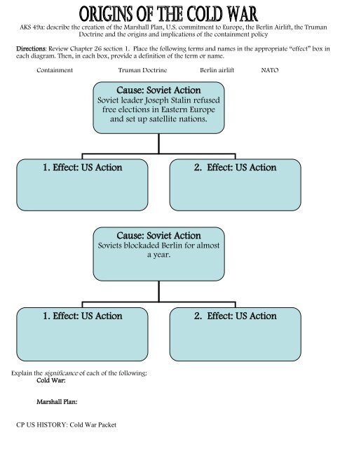
AKS 49a: describe the creation of the Marshall Plan, U.S. commitment to Europe, the Berlin Airlift, the TrumanDoctrine and the origins and implications of the containment policyDirections: Review Chapter 26 section 1. Place the following terms and names in the appropriate “effect” box ineach diagram. Then, in each box, provide a definition of the term or name.Containment Truman Doctrine Berlin airlift NATOCause: Soviet ActionSoviet leader Joseph Stalin refusedfree elections in Eastern Europeand set up satellite nations.1. Effect: US Action 2. Effect: US ActionCause: Soviet ActionSoviets blockaded Berlin for almosta year.1. Effect: US Action 2. Effect: US ActionExplain the significance of each of the following:<strong>Cold</strong> <strong>War</strong>:Marshall Plan:CP US HISTORY: <strong>Cold</strong> <strong>War</strong> <strong>Packet</strong>
AKS 49b: explain the impact of the communist regime in China, the outbreak of the Korean <strong>War</strong>, and how theseevents contributed to the rise of Senator Joe McCarthyAs you read chapter 26 section 2, fill out the chart below by writing answers to the questions in the appropriateboxes.Civil <strong>War</strong> in ChinaCivil <strong>War</strong> in Korea1. Which side did theUS support, and why?2. What did the US doto affect the outcomeof the war?3. What was theoutcome of the war?Be sure to explainWHAT CHANGED (ifanything).4. How did theAmerican public reactto that outcome, andwhy?Define the following.o Mao Zedong:o Chiang Kai-shek:o Taiwan (Formosa):o 38 th Parallel:CP US HISTORY: <strong>Cold</strong> <strong>War</strong> <strong>Packet</strong>
AKS 49f: explain the role of geography on the U.S. containment policy, the Korean <strong>War</strong>, the Bay of Pigs, theCuban Missile Crisis and the Vietnam <strong>War</strong>Korean <strong>War</strong> Map ActivityBasic Map Questions – Use the maps below to answer the following questions.1. What serves as the dividing line between North Korea and South Korea? ______________________________2. What is the capital of North Korea? ____________________________________________________________3. What is the capital of South Korea? ____________________________________________________________4. What 2 countries border North Korea? _________________________________________________________5. What country borders South Korea to the south? _________________________________________________6. What bodies of water surround North and South Korea? ___________________________________________7. What type of landform is North and South Korea combined? ________________________________________CP US HISTORY: <strong>Cold</strong> <strong>War</strong> <strong>Packet</strong>
Directions: Use Chapter 30, Section 1 to complete the following tasks.Map Skills:1. Draw the division line between North and South Vietnam.2. Color N. Vietnam Red and South Vietnam Blue3. Locate and identify the countries of Laos and Cambodia.Color them with a color of your choice.4. Label the cities of Hanoi and Saigon.Analyzing the Vietnam <strong>War</strong>:5. Why did the United States become involved in the Vietnam<strong>War</strong>?6. What is the Tonkin Gulf Resolution?Need help? See the map on page 939 ofyour textbookCP US HISTORY: <strong>Cold</strong> <strong>War</strong> <strong>Packet</strong>
Step 1: Use the word bank to complete the phrases below.Stalin satelliteElections EasternMilitary United States1948 airliftBlockade YaltaBerlin uselessCommunist 1945The decision to divide Germany into zones of occupation was made in _______ at the _________ Conference.Following the occupation of Germany, ___________ was supposed to hold free ___________. Instead, he refusedto remove his _____________ forces and turned the nations of ____________ Europe into ___________communist nations (including East Germany). In ___________, Stalin tried to turn all of __________, the capitalof Germany, communist. He ordered a _____________ and shut down all ground transportation into WestBerlin. In response, the _______________ began the Berlin _____________. For 11 months US and Britishplanes flew in supplies, food and fuel, which made the blockade ________________. In 1949, Stalin admitted____________ and the US claimed the airlift a success. The Allied Powers had successfully prevented Berlin frombecoming _________________.Step 2: Answer the questions based on the photograph.1. WHAT do you see in the image?2. WHO might have produced this poster?3. WHO is the intended audience (who is meant tosee this image)?4. WHAT is the message of this poster?CP US HISTORY: <strong>Cold</strong> <strong>War</strong> <strong>Packet</strong>
Directions: Using the provided political cartoon, answer the following questions.1. What is the event or issue that inspired the cartoon?2. Are there any real people in the cartoon? Who is portrayed in the cartoon?3. Are there symbols in the cartoon? What are they and what do they represent?4. What is the cartoonist’s opinion about the topic portrayed in the cartoon?CP US HISTORY: <strong>Cold</strong> <strong>War</strong> <strong>Packet</strong>
AKS 49f: explain the role of geography on the U.S. containment policy, the Korean <strong>War</strong>, the Bay of Pigs, theCuban Missile Crisis, and the Vietnam <strong>War</strong>Step 1: On the map labeled “The <strong>Cold</strong> <strong>War</strong> in Europe,” complete the following.1. Label the North Sea, the Atlantic Ocean, the Baltic Sea, the Mediterranean Sea, and the Black Sea. Color allbodies of water BLUE.2. Label the <strong>War</strong>saw Pact (Soviet Bloc) nations: the U.S.S.R., Poland, East Germany, Czechoslovakia, Hungary,Romania, and Bulgaria. Color these nations RED.3. Label the North Atlantic Treaty Organization countries in Europe: Great Britain, the Netherlands, Norway,Belgium, Denmark, West Germany, Portugal, Italy, Greece, Turkey, Luxembourg, France, and Iceland.(Remember, the U.S. and Canada were also members but are not shown on this map.) Color the NATOnations GREEN.4. Label neutral countries, the ones that were not a part of either treaty organization. Color Ireland, Sweden,Spain, Finland, Switzerland, and Austria YELLOW. Color Yugoslavia and Albania PINK.Step 2: For questions 5 and 6: Please answer at the bottom of your map.5. Looking at the way the map is divided into NATO and <strong>War</strong>saw Pact nations, explain how such a pattern ofalliances could cause suspicions, anxiety, and fear to arise between nations, and how such fears could haveescalated the tensions of the <strong>Cold</strong> <strong>War</strong>.6. Based on the map, why do you think the neutral countries might have been afraid to join either alliance?Place the following events in theproper time period on your owntimeline (can be on the back ofyour map).Berlin AirliftBerlin Wall is builtCuban Missile CrisisKorean ConflictMcCarthyism in the U.S.NATO is organizedfirst SALT agreement is signedU-2 IncidentVietnam <strong>War</strong><strong>War</strong>saw Pact is organizedCP US HISTORY: <strong>Cold</strong> <strong>War</strong> <strong>Packet</strong>
CP US HISTORY: <strong>Cold</strong> <strong>War</strong> <strong>Packet</strong>