

Marine Cadastres - Challenges and Opportunities for Land Surveyors
Marine Cadastres - Challenges and Opportunities for Land Surveyors
Marine Cadastres - Challenges and Opportunities for Land Surveyors

Create successful ePaper yourself
Turn your PDF publications into a flip-book with our unique Google optimized e-Paper software.
the three main objectives of the workshop <strong>and</strong> the development of possible resolutions<br />
<strong>and</strong> recommendations to the PCGIAP on administering the marine environment.<br />
A background paper discussing the “Issues in Developing <strong>Marine</strong> SDI” was presented<br />
by the Workshop Chair, Professor Ian Williamson. As part of this presentation, the key<br />
environmental, social <strong>and</strong> economic factors <strong>and</strong> issues driving the development of<br />
<strong>Marine</strong> SDI were highlighted. It was also noted that whilst access to spatial data aids in<br />
effective decision-making to achieve sustainable development, the majority of SDI<br />
initiatives stop at the l<strong>and</strong>-sea interface. This encourages marine data to be held in<br />
various <strong>for</strong>mats, at various accuracies within ‘data silos’. There<strong>for</strong>e, there is a need to<br />
identify technical, legal <strong>and</strong> institutional arrangements hindering coordination <strong>and</strong><br />
management of the marine environment.<br />
Delegates attending the workshop then broke into groups with each discussing different<br />
aims <strong>and</strong> objectives. Some of the major points highlighted during the discussion<br />
sessions include:<br />
• Importance of including a marine component within the SDI policies as part of<br />
countries obligations to UNCLOS.<br />
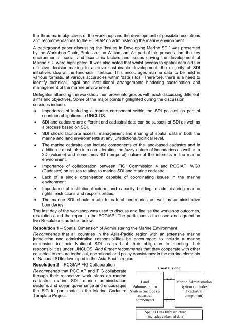
• SDI <strong>and</strong> cadastre are different <strong>and</strong> cadastral data can be subsets of SDI as well as<br />
a process based on SDI.<br />
• SDI should facilitate access, management <strong>and</strong> sharing of spatial data in both the<br />
marine <strong>and</strong> l<strong>and</strong> environments at any jurisdictional/political level.<br />
• The marine cadastre can include components of the l<strong>and</strong>-based cadastre <strong>and</strong> in<br />
addition it must take into consideration the fuzzy nature of boundaries as well as a<br />
3D (volume) <strong>and</strong> sometimes 4D (temporal) nature of the interests in the marine<br />
environment.<br />
• Importance of collaboration between FIG, Commission 4 <strong>and</strong> PCGIAP, WG3<br />
(Cadastre) on issues relating to marine SDI <strong>and</strong> marine cadastre.<br />
• Lack of a single organisation capable of coordinating issues in the marine<br />
environment.<br />
• Importance of institutional re<strong>for</strong>m <strong>and</strong> capacity building in administering marine<br />
rights, restrictions <strong>and</strong> responsibilities.<br />
• The marine SDI should relate to natural boundaries as well as administrative<br />
boundaries.<br />
The last day of the workshop was used to discuss <strong>and</strong> finalise the workshop outcomes,<br />
resolutions <strong>and</strong> the report to the PCGIAP. The participants discussed <strong>and</strong> agreed on<br />
five Resolutions as listed below:<br />
Resolution 1 – Spatial Dimension of Administering the <strong>Marine</strong> Environment<br />
Recommends that all countries in the Asia-Pacific region with an extensive marine<br />
jurisdiction <strong>and</strong> administrative responsibilities be encouraged to include a marine<br />
dimension in their National SDI as part of their obligation to meeting their<br />
responsibilities under UNCLOS. And further recommends that they cooperate with other<br />
countries to ensure technical, operational <strong>and</strong> policy consistency in the marine elements<br />
of National SDIs developed in the Asia-Pacific region.<br />
Resolution 2 – PCGIAP-FIG Collaboration<br />
Coastal Zone<br />
Recommends that PCGIAP <strong>and</strong> FIG collaborate<br />
through their respective work plans on marine<br />
cadastre, marine SDI, marine administration<br />
systems <strong>and</strong> ocean governance <strong>and</strong> encourages<br />
the FIG to participate in the <strong>Marine</strong> Cadastre<br />
Template Project.<br />
L<strong>and</strong><br />
Administration<br />
System (includes a<br />
cadastral<br />
component)<br />
Spatial Data Infrastructure<br />
(includes cadastral data)<br />
<strong>Marine</strong> Administration<br />
S ystem (includes<br />
a cadastral<br />
component)


