Duffins Creek - Toronto and Region Conservation Authority
Duffins Creek - Toronto and Region Conservation Authority
Duffins Creek - Toronto and Region Conservation Authority

You also want an ePaper? Increase the reach of your titles
YUMPU automatically turns print PDFs into web optimized ePapers that Google loves.
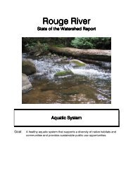
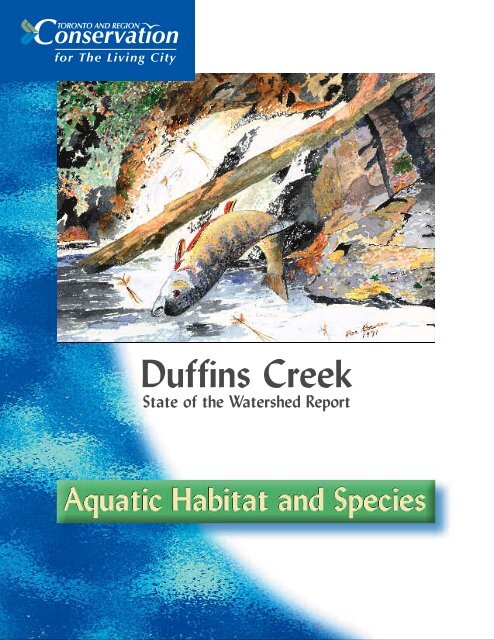
<strong>Duffins</strong> <strong>Creek</strong>State of the Watershed Report
Aquatic Habitat <strong>and</strong> SpeciesJune 2002Other topics in this series for both the <strong>Duffins</strong> <strong>Creek</strong> <strong>and</strong> the Carruthers <strong>Creek</strong> include:• Introduction• Study Area• Human Heritage• Greenspace, Trails <strong>and</strong> Recreation• L<strong>and</strong> Use• Air Quality• Climate• Surface Water Quality• Surface Water Quantity• Stormwater Management• Fluvial Geomorphology• Hydrogeology• Terrestrial Natural HeritageCover image: Rainbow trout.Image credit: Bowen, RaeThis document is intended to be shared for non-commercial use.We are promoting the electronic use of this documentto minimize the consumption of paper resources.<strong>Toronto</strong> <strong>and</strong> <strong>Region</strong> <strong>Conservation</strong>, 5 Shoreham Drive, Downsview, Ontario M3N 1S4Telephone: (416) 661-6600 • Fax: (416) 661-6898 • www.trca.on.ca
Table of ContentsIntroduction to Aquatic Habitat <strong>and</strong> Species . . . . . . . . . . . . . . . . . . . .2Riverine Habitat . . . . . . . . . . . . . . . . . . . . . . . . . . . . . . . . . . . . . . . . . . . . . .3Lacustrine Habitat . . . . . . . . . . . . . . . . . . . . . . . . . . . . . . . . . . . . . . . . . . .10Estuarine Habitat . . . . . . . . . . . . . . . . . . . . . . . . . . . . . . . . . . . . . . . . . . . .10Data Gaps . . . . . . . . . . . . . . . . . . . . . . . . . . . . . . . . . . . . . . . . . . . . . . . . . .11Summary . . . . . . . . . . . . . . . . . . . . . . . . . . . . . . . . . . . . . . . . . . . . . . . . . . .12References . . . . . . . . . . . . . . . . . . . . . . . . . . . . . . . . . . . . . . . . . . . . . . . . . .13Tables <strong>and</strong> FiguresTable 1: <strong>Duffins</strong> <strong>Creek</strong> Cumulative Species List . . . . . . . . . . . . . . . . . . . . . . . . . . . . . . . . . . . . . . . . . . . .5Table 2: <strong>Duffins</strong> <strong>Creek</strong> Estuarine Marsh Cumulative Species List. . . . . . . . . . . . . . . . . . . . . . . . . . . . . . .11Figure 1: An Index of Biological Integrity (IBI) . . . . . . . . . . . . . . . . . . . . . . . . . . . . . . . . . . . . . . . . . . . . .7Figure 2: The 2000 Survey of 32 Sites in the <strong>Duffins</strong> . . . . . . . . . . . . . . . . . . . . . . . . . . . . . . . . . . . . . . . . .91
Introduction to AquaticHabitat <strong>and</strong> SpeciesThe health of the aquatic environment <strong>and</strong> the condition of the <strong>Duffins</strong><strong>Creek</strong> watershed are interconnected. This is because the aquaticenvironment is directly affected by the quality <strong>and</strong> quantity of waterthat flows over or through the l<strong>and</strong>. The health of the aquatic habitat,therefore, is an indicator of the health of the watershed.The aquatic ecosystem is most often described as fish habitat since fishcommunities are important resources, <strong>and</strong> as such, have a long historyof being used as indicators of aquatic ecosystem health. Aquatic habitatis an integral part of the watershed’s ecosystem as it provides feeding,breeding <strong>and</strong> rearing areas for resident <strong>and</strong> migratory fish <strong>and</strong>invertebrate species. Within the watershed, aquatic habitats can bedivided into several different habitat categories, on the basis ofsuitability for differentiating aquatic communities. These habitatcategories fall into three broad groups: riverine habitat (creeks <strong>and</strong>rivers), lacustrine habitat (ponds <strong>and</strong> lakes) <strong>and</strong> estuarine habitat(coastal marsh). In the following sections each habitat category isidentified <strong>and</strong> its significance, condition <strong>and</strong> any changes in conditionover time are described.In 2000, a survey of fish communities <strong>and</strong> habitat was conducted toprovide a benchmark of our current knowledge of the watershed,allowing for the identification of significant management issues as wellas gaps in our knowledge. A comprehensive analysis of the fishcommunity, aquatic habitat <strong>and</strong> a management plan for the aquaticecosystem will be completed early in 2002.2
Riverine HabitatRiverine habitat is found in rivers <strong>and</strong> creeks <strong>and</strong>can be divided into coldwater <strong>and</strong> warmwaterhabitat categories. The determinants of whichtype of habitat exists in a particular location is aresult of a number of watershed <strong>and</strong> more locallevel characteristics that affect fundamentalcomponents of the habitat such as flow regime<strong>and</strong> water temperature. The underlying geology,in conjunction with riparian vegetation (i.e.vegetation adjacent to streams) <strong>and</strong> l<strong>and</strong> use,produce the flow, water temperature, water quality<strong>and</strong> associated aquatic community that we seetoday. To underst<strong>and</strong> the current health of fishcommunities <strong>and</strong> their potential, it is necessaryto interpret these communities in the context ofthese three factors.<strong>Duffins</strong> <strong>Creek</strong> begins on the extensive s<strong>and</strong> <strong>and</strong>gravel deposits of the Oak Ridges Moraine, whichforms the height of l<strong>and</strong> in the northern part ofthe watershed. To the south, the river crosses thesilt <strong>and</strong> clay till plains of glacial Lake Markham<strong>and</strong> the slightly s<strong>and</strong>ier Halton Till. Even fartherdownstream, the creek crosses the s<strong>and</strong>s <strong>and</strong>gravels of the Lake Iroquois Shoreline <strong>and</strong> thenthe silt <strong>and</strong> clay deposits of the old lake bed.Below the deposits at the surface, the geologyalternates between the layers of lacustrine silt<strong>and</strong> clay <strong>and</strong> fluvial deposits (i.e. associated withstreams or rivers) of s<strong>and</strong> <strong>and</strong> gravel. Many ofthese deeper deposits reach the surface within thedeep valleys in the lower part of the watershed.Each of the geologic deposits the creek drainsfrom or crosses, influences the characteristics ofthe creek <strong>and</strong> thus the conditions that supportthe aquatic communities. For further details referto the Hydrogeology chapter in this series.The principal way in which the geology of thewatershed influences the fish community is bymoderating flow <strong>and</strong> water temperature. Thecoarse surficial deposits encourage infiltration ofsurface water across the l<strong>and</strong>scape on which theyoccur <strong>and</strong> thus reduce overl<strong>and</strong> surface flows tolocal streams. As a result, streams draining fromareas with coarse soils such as the Oak RidgesMoraine or the Iroquois Shoreline tend to have lessfrequent storm flow conditions <strong>and</strong> a significantbaseflow component due to groundwaterdischarge. This combination results in an overallmore stable flow regime, which is characteristicof streams in the <strong>Duffins</strong> <strong>Creek</strong> watershed.Groundwater, a characteristic related to geology,is another important factor that determines thetype of habitat <strong>and</strong> associated fish communitythat can be sustained. Groundwater seeps orflows into the creek where the aquifers (thesubsurface water-bearing deposits) are exposed.The more groundwater discharge into thewatercourse, the greater the potential forcoldwater habitat. At 8-10°C year round,groundwater is the source of cold water towatercourses. The addition of warm flow fromparking lots or streets moderates the cold water<strong>and</strong> reduces the area of coldwater habitat.A good way to underst<strong>and</strong> <strong>and</strong> measure whethergroundwater inputs are significant for aquatichabitat is to examine the ratio of baseflow, ameasure of groundwater input, relative to theannual flow. Research indicates that a ratio ofgreater than 20 per cent groundwater dischargeto average annual flow is required to supporttrout species. This occurs when roughly 20 percent of the total average annual flow is derivedfrom groundwater discharge into the creek.Current estimates of base flows in the watershedrange from 50 per cent for <strong>Duffins</strong> <strong>Creek</strong> southof Highway 2, to 37 per cent for the West<strong>Duffins</strong> at Green River, 61 per cent for the East<strong>Duffins</strong> above Pickering, <strong>and</strong> up to 50-60 percent for Ganatsekiagon <strong>Creek</strong> <strong>and</strong> Urfe <strong>Creek</strong>(Eyles et al., 1997; Sibul et al., 1977).Currently, <strong>Duffins</strong> <strong>Creek</strong> contains 380 kilometresof watercourses. They are in relatively goodcondition <strong>and</strong> are dominated by cold wateraquatic communities that include sculpin, trout<strong>and</strong> numerous other fish species. Based on thedatabase of fish collections at the Royal OntarioMuseum’s Ichthyology Department, there havebeen 45 riverine species of fish found in the3
4<strong>Duffins</strong> watershed (Table 1). Included in this listare nine non-native species: sea lamprey, rainbowtrout, brown trout, coho salmon, chinooksalmon, alewife, goldfish, white perch <strong>and</strong>common carp. Although non-native, the trout<strong>and</strong> salmon species are considered by some to bedesirable from a recreation st<strong>and</strong>point. At onetime trout <strong>and</strong> salmon were stocked in the creek;presently only brown trout are still beingstocked. Atlantic salmon is the only knownextirpated species once found in <strong>Duffins</strong> <strong>Creek</strong>(ODPD, 1956). The creek is currently being usedby the Ministry of Natural Resources to researchthe habitat requirements <strong>and</strong> to evaluate thefeasibility of restoring Atlantic salmon to LakeOntario tributaries.In the 2000 survey of the <strong>Duffins</strong> fish community,28 species were encountered (Table 1). Thisincluded three non-native species: chinooksalmon, rainbow trout <strong>and</strong> brown trout. Thefewer species found in the 2000 survey is likely areflection of the decreased extent of sampling,the sites selected for sampling <strong>and</strong> possibly somespecies losses. Coldwater streams in the upper<strong>and</strong> middle reaches of the <strong>Duffins</strong> <strong>Creek</strong>watershed provide habitat for species such asbrook trout, <strong>and</strong> slimy <strong>and</strong> mottled sculpin.They also provide habitat for species at risk suchas redside dace (Clinostomus elongatus). In thelower reaches of the west <strong>and</strong> east <strong>Duffins</strong> <strong>Creek</strong>there is coldwater habitat that supports ahealthy, self-sustaining, rainbow trout population.It is also likely that chinook <strong>and</strong> coho salmonspawn successfully in the lower reaches. Thesespecies of salmon <strong>and</strong> trout are separated fromthe native brook trout populations by several instreambarriers that prevent the upstreammovement of migratory species. Previous studieshave shown that the non-native salmon <strong>and</strong>trout would out-compete the native brook troutif their distributions were allowed to overlap.According to the MNR District FisheriesManagement Plan 1989-2000, the <strong>Duffins</strong><strong>Creek</strong> watershed supports primarily brook <strong>and</strong>brown trout in the headwaters <strong>and</strong> migratorysalmonids below Highway 7. Most of thewatershed is considered coldwater habitat withthe exception of Stouffville <strong>Creek</strong>, <strong>and</strong> the lower<strong>Duffins</strong> below Highway 401. Stouffville <strong>Creek</strong>once was coldwater habitat, but now it iswarmwater because of the presence of theStouffville reservoir, an online pond, <strong>and</strong> a lack ofwoody riparian vegetation to shade the stream.Conversely, the lower <strong>Duffins</strong> <strong>Creek</strong> is a naturalwarmwater reach. This a consequence of the sizeof the creek <strong>and</strong> the low quantities ofgroundwater input into the creek at this locationin the watershed. The lower <strong>Duffins</strong> <strong>and</strong>associated marsh provide good habitat for anumber of warmwater species such as smallmouthbass, northern pike <strong>and</strong> pumpkinseed.The ecological health of a fish community can bequantified through the calculation of an index ofbiological integrity (IBI). The IBI figuresquantifies the ‘health’ of the fish community byincorporating species richness, trophic balance,the abundance of fish, <strong>and</strong> the presence ofindicator species into one index. This method wasfirst proposed by Karr (1981) <strong>and</strong> was furthermodified <strong>and</strong> calibrated for southern Ontariostreams by Steedman (1988). Interestingly,fisheries information from the <strong>Duffins</strong> watershedwas used by Steedman to calibrate the IBI forsouthern Ontario streams. More importantly, hefound that many (77 per cent) locations in thewatershed had good to excellent fishcommunities (Figure 1).Surveys from the 1990s found similar conditions,which is expected, because there have been fewchanges in the watershed that would impact thefish community. Overall, analysis of the watershedfrom the 1950s to the 1990s has demonstrated ageneral increase in the number of species <strong>and</strong> thedistribution of trout species (Jones <strong>and</strong> Guy,1997). The 2000 survey of 32 sites in the <strong>Duffins</strong>resulted in IBI scores from fair to excellent, witha median score of good (Figure 2). This is a goodresult given that a high percentage of the sitesscored good (53 per cent), three were excellent (9per cent) <strong>and</strong> no sites were in poor condition orhad no fish present (Figure 2).
Table 1: <strong>Duffins</strong> <strong>Creek</strong> Cumulative Species ListCOMMON NAME SCIENTIFIC NAME PRESENT IN 2000 SURVEYLAMPREY FAMILYAmerican brook lamprey Lampetra appendix ünorthern brook lamprey 5 Ichthyomyzon fossor üsea lamprey 1, 4Petromyzon marinusSALMON FAMILYchinook salmon 1 Oncorhynchus tshawytscha ücoho salmon 1Oncorhynchus kisutchrainbow trout 1 Oncorhynchus mykiss üAtlantic salmon 3Salmo salarbrown trout 6 Salmo trutta übrook trout Salvelinus fontinalis üSUCKER FAMILYwhite sucker Catostomus commersoni ünorthern hog sucker Hypentelium nigricansMINNOW FAMILYgoldfish 2Carassius auratusnorthern redbelly dace Phoxinus eos üfinescale dacePhoxinus neogaeusredside dace 5Clinostomus elongatuscommon carp 2Cyprinus carpiobrassy minnowHybognathus hankinsonihornyhead chubNocomis biguttatusriver chubNocomis micropogoncommon shiner Notropis cornutus üspotfin shiner Cyprinella spilopterus üs<strong>and</strong> shinerNotropis stramineuscommon shiner xLuxilus cornutus xcreek chub Semotilus atromaculatus übluntnose minnow Pimephales notatus üfathead minnow Pimephales promelas üblacknose dace Rhinichthys atratulus ülongnose dace Rhinichthys cataractae ücreek chub Semotilus atromaculatus üpearl daceMargariscus margaritacentral stonerollerCampostoma anomalumContinues on page six.5
Table 1: Continued from page fiveCOMMON NAME SCIENTIFIC NAME PRESENT IN 2000 SURVEYCATFISH FAMILYyellow bullheadAmeiurus natalisbrown bullhead Ictalurus nebulosus üchannel catfish 4Ictalurus punctatusstonecatNoturus flavusFRESHWATER EEL FAMILYAmerican eel 4Anguilla rostraSTICKLEBACK FAMILYbrook stickleback Culea inconstans üthree-spine stickleback Gosterosteus aculeatusTEMPERATE BASS FAMILYwhite perch 1, 2Morone americanaSUNFISH FAMILYrock bass Ambloplites rupestris üpumpkinseed Lepomis gibbosus üsmallmouth bass Micropterus dolomieui ülargemouth bass Micropterus salmoides üPERCH FAMILYyellow perchPerca flavescensrainbow darter Etheostoma caeruleum üIowa darter Etheostoma exile üjohnny darter Etheostoma nigrum ülogperch 4 Percina caproides üleast darterEtheostoma micropercaSCULPIN FAMILYmottled sculpin Cottus bairdi üslimy sculpin Cottus cognatus ü1 introduced species; 2 naturalized species; 3 extirpated species; 4 found only in estuarine habitat;5 Species at Risk, classified as “special concern” COSEWIC;6 resident brown trout are naturalized while migratory brown trout are introduced.6Invertebrate samples are also used to assesshabitat condition <strong>and</strong> water quality because theyare a food source for many fish species <strong>and</strong> respondquickly to environmental perturbations. Ingeneral, mayflies (Ephemeroptera) <strong>and</strong> stoneflies(Plecoptera) are considered the most sensitivebenthic taxa because they depend on clean <strong>and</strong>well-oxygenated water. An overview of theinvertebrate communities in the Seaton l<strong>and</strong>s(Ganatsekiagon, Urfe, Whitevale <strong>and</strong> West <strong>Duffins</strong>creeks) found that most sampling stations werecharacterized as having a high proportion ofpollution-sensitive species (HBT AGRA, 1994).The only sites where pollution-tolerant groups were
Figure 1:An index of biological integrity (IBI), figures quantifies the ‘health’ of the fish community by incorporatingspecies richness, trophic balance <strong>and</strong> the abundance of fish, <strong>and</strong> the presence of indicator species. Data fromSteedman’s 1988 study.7
8found were in West <strong>Duffins</strong> <strong>Creek</strong> at the Brockl<strong>and</strong>fill <strong>and</strong> at Whitevale, yet in these samples therewere still many pollution-sensitive species. Recentstudies from headwater areas in the West <strong>Duffins</strong><strong>and</strong> East <strong>Duffins</strong> subwatersheds similarly foundhigh proportion of sensitive species (TRCA, 1999).These results are a strong indicator that <strong>Duffins</strong><strong>Creek</strong> has a healthy invertebrate community.The <strong>Duffins</strong> <strong>Creek</strong> watershed has experienced anumber of changes over the years. Historically thewatershed was dominated by vast forests that hada tremendous influence on the hydrology of thewatershed. With settlement came deforestation<strong>and</strong> a variety of agricultural practices that impactedthe system but, due in part to the large amountsof groundwater discharging to the stream, thesensitive species such as brook trout were notlost. Other changes, such as transportation,urbanization, water taking, barriers <strong>and</strong> ponds,have impacted the watershed, however, theirextent within the watershed is limited <strong>and</strong> assuch the impact to aquatic habitat <strong>and</strong> specieshas not been substantive.In the past 50 or so years the condition withinsome areas of the watershed has been improving.For example, in some of the headwater areaswhere the glacial soils are poor for agriculture<strong>and</strong> in the provincial Seaton <strong>and</strong> federal airportl<strong>and</strong>s, there has been significant amounts ofregeneration of table l<strong>and</strong> <strong>and</strong> riparian forests.This increase in forest cover has led to areduction in surface flows <strong>and</strong> a stabilization ofthe overall flow regime, better aquatic habitat<strong>and</strong> an overall improvement in the condition ofsome fish communities. In fact, the fish communityin the West <strong>Duffins</strong> <strong>Creek</strong> has improved sincethe 1950s. In the 1950s first extensive fishsurvey of the <strong>Duffins</strong> <strong>Creek</strong> watershed, sensitivespecies such as brook trout <strong>and</strong> sculpin werelargely restricted to the headwater areas. Sincethe 1950s the conditions have improved <strong>and</strong>these species have extended their range to otherareas (Jones <strong>and</strong> Guy, 1997). With many areasstill requiring woody riparian vegetation, there isroom for further improvements in the fishcommunity <strong>and</strong> the aquatic system in general.Improvements have not occurred with respect tothe mitigation or removal of in-stream barriers.Structures that act as barriers include dams,weirs, level crossings <strong>and</strong> some culverts. Many ofthe large structures were created historically toproduce power for grist or saw mills. In morerecent years they were built to create recreationalponds. Other barriers may include structures thatincrease water velocities. These velocity barriersmay be created through incorrectly sized culvertsthat increase water velocities to the point wherethey do not allow for fish passage. Generallythese structures serve as barriers to migratoryfish movement upstream <strong>and</strong> may bar fish accessto important spawning or rearing areas. Barriersalso fragment resident fish populations bylimiting their movement within the watershed.The presence of barriers in the watershed canhave a positive or negative effect. In the <strong>Duffins</strong>,some of these barriers are helping to protectnative brook trout populations from migratorysalmonids or prevent sea lamprey from accessingpotential areas. Other barriers fragment brooktrout habitat, limiting access to summer refugiaor fall spawning habitat. Managing the effects ofinstream barriers is an important issue that mustbe addressed in the development of a watershedfisheries management plan.Future l<strong>and</strong> use activities <strong>and</strong> developmentswithin the watershed should address thedecreased ability of urbanized areas to infiltratewater <strong>and</strong> their ability to speed up the movementof water towards the creek. These alter thehydrologic cycle toward less groundwaterinfiltration <strong>and</strong> greater surface runoff. If thechanges in the surface <strong>and</strong> groundwater regimesare large enough, they can significantly impactboth coldwater <strong>and</strong> warmwater habitat, makingpreservation of the current regime important.
Figure 2:The 2000 survey of 32 sites in the <strong>Duffins</strong> resulted in IBI scores from fair to excellent, with a medianscore of good.9
10LacustrineHabitatLacustrine habitat is characterized by thepresence of st<strong>and</strong>ing water. Two types oflacustrine habitat found in the <strong>Duffins</strong> <strong>Creek</strong>watershed are online <strong>and</strong> offline ponds <strong>and</strong> lakes.In total, these ponds <strong>and</strong> lakes cover an area ofmore than 2.5 km 2 in the watershed. There areapproximately 172 online ponds in the watershedaveraging 0.5 ha in size. These ponds are directlyconnected to the creek with the creek passingdirectly through the waterbody. Offline pondsmay be completely isolated from the creek withlittle or no connection, or indirectly connectedthrough a pipe that directs some flow from thecreek to the pond. There are approximately 746offline ponds in the watershed.Ponds can also be created through a variety ofacts of nature. Many ponds are created as a resultof beaver building dams with wood <strong>and</strong> otherdebris. These structures are generally not aconcern as they are natural <strong>and</strong> tend to betransient in nature. Ponds may also be formedthrough the normal migration of the creek, whichcan create oxbow lakes or ponds. Kettle lakeswere also formed by nature through the meltingof trapped ice on the Oak Ridges Moraine duringthe last ice age. Kettle lakes are common in theheadwater areas, with the greatest density foundin the Township of Uxbridge.There are a large number of human-made pondsin the watershed that were created to power mills,water livestock or to provide aesthetic or recreationalvalues. Many of these <strong>and</strong> other ponds are capableof supporting small populations of brook trout.Some ponds were created to enhance brook troutpopulations. One such pond is the 8 ha SecordPond located in the upper west <strong>Duffins</strong> <strong>Creek</strong>southeast of Goodwood. Although there wasrecreational benefit from the creation of this pond,it also prevented trout from accessing spawninghabitat on significant groundwater discharge zonesupstream/downstream of the pond. Most of thekettle lakes <strong>and</strong> ponds in the watershed are muchsmaller <strong>and</strong> support correspondingly smaller fish<strong>and</strong> fish communities.Online ponds are depositional areas thataccumulate sediments <strong>and</strong> tend to evolve intowetl<strong>and</strong>s <strong>and</strong> eventually upl<strong>and</strong>s over time. Theaccumulated sediments can pose a risk todownstream fish communities if released fromthe pond or reservoir. Online ponds may alsocontribute to warming of the creek because largeponds <strong>and</strong> lakes, such as the Stouffville Reservoir,slow the water <strong>and</strong> allow the surface temperaturesto rise. This results in increased temperaturesdownstream <strong>and</strong> may make the habitat lesssuitable for coldwater species. In some cases thiswarming effect can be mitigated if the water isreleased from the bottom of the pond where it isusually cooler.Estuarine HabitatThe coastal marsh located at the confluence of<strong>Duffins</strong> <strong>Creek</strong> <strong>and</strong> Lake Ontario covers 41 ha.This area is of critical importance to many fishspecies. A total of 27 species have been recordedfrom the marsh area (Table 2). Species found hereinclude creek species, but also typically lakeresident species such as northern pike, yellowperch, gizzard shad, alewife, white bass <strong>and</strong>white perch. Of importance is that the areaprovides spawning <strong>and</strong> rearing habitat for 18 ofthese species. In total, 81 per cent of the 27species found in the marsh area use it for eitherspawning or rearing purposes (Stephenson, 1988).Four species found in the marsh – the commoncarp, alewife, rainbow trout <strong>and</strong> white perch –are introduced species.This area is designated as an environmentallysignificant area (ESA), an area of natural <strong>and</strong>scientific interest (ANSI), as well as a provinciallysignificant wetl<strong>and</strong> because of its importance tofish, plants <strong>and</strong> other wildlife species. There areseveral attributes that make the marsh animportant area for fish. First, this area serves as atransition zone between the creek <strong>and</strong> lake. The
marsh is affected by changes in the watershed aswell as the water levels that occur in the lake.This transition provides ideal spawning <strong>and</strong>rearing conditions. Second, the marsh is a veryproductive area. This occurs because of the lowgradient that serves as a depositional area forupstream sediments. The low gradient in thispart of the watershed <strong>and</strong> sediments create awide flood plain that is seasonally inundatedwith water. The sediments also provide nutrientsto the system, while the nutrients support adense weed growth that provide excellent coverfor growing fish <strong>and</strong> also provide a resource base/food source for the growing fish <strong>and</strong> prey.These estuarine marshes are under threatthroughout the Great Lakes region (Stephenson,1988). Given the marsh’s importance to the fishpopulation in the creek as well as to lake fish species,it is of critical importance to protect this area.Data gapsOne non-specific management concern is to filldata gaps. The current aquatic information on<strong>Duffins</strong> <strong>Creek</strong> is by no means complete <strong>and</strong> thereare a number of data gaps that will influence ourability to effectively manage the fisheriesresources <strong>and</strong> track changes over time. Thesegaps include the following:• A lack of a good hydrology model for baseflow<strong>and</strong> frequent flows in the watershed.Management of the flow regime within thewatershed is critical to the protection of itsresources, especially the aquatic ecosystem.Creation of a continuous simulation model toallow prediction of baseflows <strong>and</strong> frequent flowsis critical to developing an underst<strong>and</strong>ing ofwhat will be necessary to protect the watershed.Table 2: <strong>Duffins</strong> <strong>Creek</strong> EstuarineMarsh Cumulative Species ListCOMMON NAME SCIENTIFIC NAMEalewifeAlosa pseudoharengusgizzard shad Dorosoma cepedianumrainbow trout Oncorhynchus mykissrainbow smelt Osmerus mordaxnorthern pike Esox luciuswhite sucker Catostomus commersonicarpCyprinus carpiogolden shiner Notemigonus crysoleucasemerald shiner Notropis antherinoidescommon shiner Luxilus cornutusspottail shiner Notropis hudsoniusspotfin shiner Notropis spilopterusbluntnose minnow Pimephales notatusfathead minnow Pimephales promelasblacknose dace Rhinichthys atratuluslongnose dace Rhinichthys cataractaecreek chubSemotilus atromaculatusbrown bullhead Ameiurus nebulosuswhite perch Moreone americanawhite bassMorone chrysopsrock bassAmbloplites rupestrispumpkinseed Lepomis gibbosussmallmouth bass Micopterus dolomieuilargemouth bass Micropterus salmoidesyellow perch Perca flaveseensjohnny darter Etheostoma nigrumlogperchPercina caprodesSource: TRCA, OMNR• Underst<strong>and</strong>ing <strong>and</strong> managing anglingpressure to determine if it is impacting fishcommunities is critical. To answer this question,spring <strong>and</strong> summer creek surveys are neededto quantify angling pressure.11
SummaryOf all the watersheds within the TRCA jurisdiction, <strong>Duffins</strong><strong>Creek</strong> has one of the most intact fish communities <strong>and</strong> may havethe potential for successful reintroduction of Atlantic salmon.Since initial settlement, many riparian areas that were oncedeforested have been left to regenerate. Much of thisregeneration was not planned but occurred ostensibly becausemany areas in the watershed were unsuitable for agriculture <strong>and</strong>were subsequently ab<strong>and</strong>oned. Now, because there has beenlittle development in the mid- to upper reaches, the streamcommunity is in relatively good condition. Nevertheless, thereare several measures that can be implemented to better managethe aquatic ecosystem including improving fish passage whereappropriate, planting woody riparian vegetation <strong>and</strong>reforestation of table l<strong>and</strong>s.12
ReferencesEyles, N., J. Boyce <strong>and</strong> R. Gerber, 1997. Hydrogeological Study of the NorthPickering Development Corporation L<strong>and</strong>s <strong>and</strong> the <strong>Duffins</strong> <strong>Creek</strong> Watershed.Prepared for the North Pickering Development Corporation. (CD Romavailable from TRCA)HBT AGRA Ltd., 1994. Seaton L<strong>and</strong>s as a Natural Ecosystem. Report to theSeaton Interim Planning Team. 139pp <strong>and</strong> Appendix.Jones, M. <strong>and</strong> M. Guy, 1997. Seaton L<strong>and</strong>s Stream Assessment: Aquatic Habitat<strong>and</strong> Fisheries. Prepared for the North Pickering DevelopmentCorporation. (CD Rom available from TRCA)Karr, J.R., 1981. Assessment of Biotic Integrity Using Fish Communities.Fisheries 6:21-27.Ontario Department of Planning <strong>and</strong> Development (ODPD), 1956. Rouge,Duffin, Highl<strong>and</strong>, Petticoat Valley <strong>Conservation</strong> Report. <strong>Toronto</strong>, Ontario.Sibul, U., K.T. Wong <strong>and</strong> D. Vallery, 1977. Groundwater Resources of the<strong>Duffins</strong> <strong>Creek</strong>-Rouge River Drainage Basins. Water Resources Report: 8.Ministry of the Environment, Water Resources Branch. <strong>Toronto</strong>,Ontario.Steedman, R.J., 1988. Modification <strong>and</strong> Assessment of an Index of BioticIntegrity to Quantify Streams in Southern Ontario. Canadian Journal ofFisheries <strong>and</strong> Aquatic Science 54: 492- 501.Stephenson, T., 1988. Fish Utilization of <strong>Toronto</strong> Area Costal Marsh Areas.M.Sc. Thesis, Department of Zoology, University of <strong>Toronto</strong>, <strong>Toronto</strong>ON, Canada. 222p.<strong>Toronto</strong> <strong>and</strong> <strong>Region</strong> <strong>Conservation</strong> <strong>Authority</strong> (TRCA), 1999. Glen MajorComplex Management Plan: Phase 1-Background Report. Downsview,Ontario.13