Section 22: Natural Hazards - Palmerston North City Council
Section 22: Natural Hazards - Palmerston North City Council
Section 22: Natural Hazards - Palmerston North City Council
You also want an ePaper? Increase the reach of your titles
YUMPU automatically turns print PDFs into web optimized ePapers that Google loves.
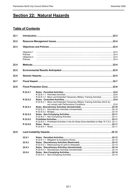
<strong>Palmerston</strong> <strong>North</strong> <strong>City</strong> <strong>Council</strong> District Plan December 2000<strong>Section</strong> <strong>22</strong>: <strong>Natural</strong> <strong>Hazards</strong>Table of Contents<strong>22</strong>.1 Introduction...................................................................................................................<strong>22</strong>-3<strong>22</strong>.2 Resource Management Issues.....................................................................................<strong>22</strong>-4<strong>22</strong>.3 Objectives and Policies................................................................................................<strong>22</strong>-4Objective 1 ..............................................................................................................................<strong>22</strong>-4Policies ..............................................................................................................................<strong>22</strong>-4Objective 2 ..............................................................................................................................<strong>22</strong>-4Policies ..............................................................................................................................<strong>22</strong>-4<strong>22</strong>.4 Methods.........................................................................................................................<strong>22</strong>-4<strong>22</strong>.5 Environmental Results Anticipated .............................................................................<strong>22</strong>-5<strong>22</strong>.6 Seismic <strong>Hazards</strong>............................................................................................................<strong>22</strong>-5<strong>22</strong>.7 Flood Hazard.................................................................................................................<strong>22</strong>-7<strong>22</strong>.8 Flood Protection Zone..................................................................................................<strong>22</strong>-8R <strong>22</strong>.8.1R <strong>22</strong>.8.2R <strong>22</strong>.8.3R <strong>22</strong>.8.4R <strong>22</strong>.8.5R <strong>22</strong>.8.6Rules: Permitted Activities.................................................................................<strong>22</strong>-8R <strong>22</strong>.8.1.1 Permitted Activities..............................................................................<strong>22</strong>-8R <strong>22</strong>.8.1.2 Minor and Extended Temporary Military Training Activities...................<strong>22</strong>-8Rules: Controlled Activities................................................................................<strong>22</strong>-9R <strong>22</strong>.8.2.1 Minor and Extended Temporary Military Training Activities which donot comply with Performance Conditions.............................................<strong>22</strong>-9Rules Discretionary Activities (Unrestricted)...................................................<strong>22</strong>-10R <strong>22</strong>.8.3.1 Discretionary Activities (Unrestricted).................................................<strong>22</strong>-10R <strong>22</strong>.8.3.2 Bridges..............................................................................................<strong>22</strong>-10Rules: Non-Complying Activities......................................................................<strong>22</strong>-11R <strong>22</strong>.8.4.1 Non-Complying Activities...................................................................<strong>22</strong>-11Prohibited Activities...........................................................................................<strong>22</strong>-11R <strong>22</strong>.8.5.1 Prohibited Activities in the Air Noise Zone identified on Map 10.7.6.3.<strong>22</strong>-11Rules: Noise......................................................................................................<strong>22</strong>-11R <strong>22</strong>.8.6.1 Noise.................................................................................................<strong>22</strong>-11<strong>22</strong>.9 Land Instability <strong>Hazards</strong>.............................................................................................<strong>22</strong>-1<strong>22</strong>2.9.1 Rules: Permitted Activities...............................................................................<strong>22</strong>-13R <strong>22</strong>.9.1.1 Mitigation & Avoidance Works...........................................................<strong>22</strong>-13<strong>22</strong>.9.2 Rules: Discretionary Activities (Restricted).....................................................<strong>22</strong>-13R <strong>22</strong>.9.2.1 Restructuring of Land in Aokautere....................................................<strong>22</strong>-13<strong>22</strong>.9.3 Rules: Discretionary Activities (Unrestricted)..................................................<strong>22</strong>-14R <strong>22</strong>.9.3.1 Discretionary Activities (Unrestricted).................................................<strong>22</strong>-14<strong>22</strong>.9.4 Rules: Non-Complying Activities......................................................................<strong>22</strong>-14R <strong>22</strong>.9.4.1 Non-Complying Activities...................................................................<strong>22</strong>-14<strong>22</strong>-1
<strong>Palmerston</strong> <strong>North</strong> <strong>City</strong> <strong>Council</strong> District Plan December 2000<strong>22</strong>-2
<strong>Palmerston</strong> <strong>North</strong> <strong>City</strong> <strong>Council</strong> District Plan December 2000<strong>22</strong>. NATURAL HAZARDS<strong>22</strong>.1 Introduction<strong>Palmerston</strong> <strong>North</strong> <strong>City</strong> is subject to a number of hazards which can be broadly divided intothree categories, viz.• Flooding hazards associated with the Manawatu River, Mangaone and Kawau andvarious smaller streams. This also includes areas subject to poor drainage which leadsto surface ponding.• Seismic <strong>Hazards</strong>, associated with the <strong>City</strong>’s close proximity to the Wellington faultsystem, which tracks along the eastern side of the Tararua Ranges, and its proximity tonumerous other earthquake sources, such as: the Indo-Australian / Pacific Platesubduction zone, which lies beneath the eastern portion of the <strong>North</strong> Island; faultsystems within the Wanganui Basin, and; fold structures within Manawatu District. Thishazard includes earthquake induced ground shaking, surface fault rupture, amplificationof ground shaking and liquefaction of soft sediment areas.• Earth movements and instability which is associated with particular soil and slopeconditions predominantly in the Aokautere area and those areas in the foothills of theTararua Ranges.The management responsibilities of the <strong>Palmerston</strong> <strong>North</strong> <strong>City</strong> <strong>Council</strong> and the Manawatu-Wanganui Regional <strong>Council</strong> regarding the avoidance or mitigation of these natural hazards areidentified within Part 6 of the Regional Policy Statement. The respective responsibilitiesassigned to each of these authorities are as follows:(A)<strong>Palmerston</strong> <strong>North</strong> <strong>City</strong> <strong>Council</strong>• developing objectives, policies and rules for the control of the use of land except in bedsof rivers and adjacent land designated or zoned for river control, for the purpose ofavoiding, remedying or mitigating any adverse effects of flood hazards;• developing objectives, policies and rules for the control of the use of land for thepurpose of avoiding, remedying or mitigating any adverse effects of land subsidencefrom activities other than soil disturbance and vegetation clearance;• developing objectives, policies and rules for the control of the use of land for thepurpose of avoiding, remedying or mitigating any adverse effects of seismic hazards.(B)Manawatu-Wanganui Regional <strong>Council</strong>• developing objectives, policies and rules for the control of the use of land in thebeds of rivers and adjacent land designated or zoned for river control, for thepurpose of avoiding, remedying or mitigating any adverse effects of flood hazards;• giving notice where appropriate of designations for river control purposes; and• developing objectives, policies and rules for the control of the use of land for thepurpose of avoiding, remedying or mitigating any adverse effects of landsubsidence as the result of soil disturbance and vegetation clearance.Given the diverse nature of these natural hazards, it is not possible to adopt a single strategyto deal with them. Rather, particular strategies are associated with each individual hazard.<strong>22</strong>-3
<strong>Palmerston</strong> <strong>North</strong> <strong>City</strong> <strong>Council</strong> District Plan December 2000<strong>22</strong>.2 Resource Management IssuesThe following resource management issues have been identified as pertaining to naturalhazards:1. The identification of the existence and location of natural hazards;2. The actual or potential costs of natural hazards to the community;3. Identification of the effects of natural hazards;4. Recognition of the need to provide for the avoidance or mitigation of natural hazards.5. The adverse effects of natural hazards on people and the natural and physicalenvironment.<strong>22</strong>.3 Objectives and PoliciesWithin the broad framework of the <strong>City</strong> View objectives, the following specific objectives andpolicies have been identified with regard to natural hazards:Objective 1To recognise the existence of natural hazards.Policies1.1 To identify any land subject to the effects of a natural hazard.1.2 To educate the community with regard to the existence, nature and threats posed bynatural hazards.Objective 2To control the type of development on land which is or might be affected by naturalhazards.Policies2.1 To exclude development on hazard-prone land where the hazard cannot be effectivelyavoided, remedied or mitigated.2.2 To establish appropriate controls to avoid, remedy or mitigate the effects of naturalhazards.<strong>22</strong>.4 Methods• District Plan Rules• Flood Protection Works of the Manawatu-Wanganui Regional <strong>Council</strong>• Building Act Provisions• Public Education<strong>22</strong>-4
<strong>Palmerston</strong> <strong>North</strong> <strong>City</strong> <strong>Council</strong> District Plan December 2000In the area of the mitigation of the effects of natural hazards, the District Plan can, throughrules and zoning, provide specific guidance or restrictions on development. This is particularlytrue with regard to the flooding and land instability hazards. In these areas the District Plan isa cost-effective method of achieving the objectives and policies. However, with a seismichazard limited information and the sheer unpredictability of an earthquake event means thatthere is little a District Plan can effectively contribute in terms of mitigation of this hazard, otherthan through the provision of informationThere are a number of other methods however, which can deal more positively with the issueof natural hazards. Physical flood protection works are significant with regard to the floodinghazard and this is the responsibility of the Manawatu-Wanganui Regional <strong>Council</strong>. Controlsput in place through the Building Act 1991 also assist in the mitigation of the effects of naturalhazards. Finally, public education is also an important tool in informing the public of theexistence of natural hazards and means of avoiding the effects of those hazards. Acombination of these other methods will most effectively achieve the rest of the objectives andpolicies in this <strong>Section</strong>.NOTE TO PLAN USERS:The <strong>City</strong> <strong>Council</strong>’s specific management responsibilities for natural hazards are outlined within<strong>Section</strong> <strong>22</strong>.1.<strong>22</strong>.5 Environmental Results AnticipatedIt is anticipated that the objectives, policies and methods of this section will achieve thefollowing results:• Avoidance of the development of areas affected by natural hazards, where thesehazards cannot be remedied or mitigated.• Greater public recognition of the existence and effects of natural hazards.<strong>22</strong>.6 Seismic <strong>Hazards</strong><strong>Palmerston</strong> <strong>North</strong> <strong>City</strong> has the unenviable position of not only being bounded to its immediatewest, north, east and south by numerous prominent and “hidden” potential earthquakesources, but also having a surface and sub-surface geology which is susceptible to groundshaking amplification and, potentially, the phenomenon known as “liquefaction”.To the west of the <strong>City</strong>, offshore, lies the Wanganui Basin which has historically been the locusof frequent swarm like seismicity. Immediately to the south and east of the <strong>City</strong>, on theeastern side of the Tararuas, lies the northern extension of the largest, most continuous andactive fault within the Manawatu-Wanganui Region - the Wellington fault system.Underlying <strong>Palmerston</strong> <strong>North</strong> and those areas to the north east and south-west of the <strong>City</strong>, at adepth of some 30km, and extending eastwards beneath Tararua District, is the Pacific andIndo-Australian plate subduction zone, where the Pacific plate is currently being forcedbeneath the Australian plate. This area is a source of numerous small to moderateearthquakes from the “downgoing slab” of the Pacific Plate, and moderate to large, andpotentially even great, earthquakes along the plate interface (which are likely to producewidespread strong shaking).In addition to these identified fault systems, numerous other smaller and buried structuresalso lie north, east, south and west of the <strong>City</strong>. These include, but are not limited to, thePohangina, Feilding, Mt Stewart-Halcombe and Himatangi anticlines and the Ruahine reversefault.<strong>22</strong>-5
<strong>Palmerston</strong> <strong>North</strong> <strong>City</strong> <strong>Council</strong> District Plan December 2000These rules are intended to provide for permitted agricultural activities while controlling noise from arange of other activities which may also occur in the Flood Protection Zone, e.g. Recreation andQuarrying. This Rule does not control certain rural activities carried on in the Flood Protection Areas,nor does it control some soil conservation and river control works. Reference should be made to<strong>Section</strong> 6 for those activities that are excluded from the above controls and for further generalinformation on noise.<strong>22</strong>.9 Land Instability <strong>Hazards</strong>Much of the elevated land on the eastern side of the <strong>City</strong> has potential for instability resultingin slippage, slumping, slope failures and general soil erosion. This reflects to a large degreethe relatively young geological age of New Zealand and is common throughout the country.In rural areas particularly, such soil and slope movements are of lesser concern as low levelsof development make the triggering of instability less likely. In addition the maintenance ofgrass coverage, and planting of trees often assists in maintaining soil and slope stability. It isin areas of urban style development that soil and slope instability become of concern. Thisissue is of major concern in the Aokautere area where dissected landforms have created steepslopes which, combined with the soil types, make instability a potential problem. In 1989 the<strong>Palmerston</strong> <strong>North</strong> <strong>City</strong> <strong>Council</strong> commissioned an Urban Land Use Capability Study (ULUCStudy) of the area of Aokautere intended for residential and rural-residential development. ThePlan identifies land which should be excluded from development or should be subject toparticular controls through its classification into developable and undevelopable land.The survey method is based on six factors being rock type, soils, dominant slope, dominantland form, dominant land cover and mass-movement hazard. The analysis assessed theimpact of these factors alone and in combination on the suitability of land for urban purposes.This resulted in land in Aokautere being classified into five classes in terms of their potentialfor urban development. These can then be placed into three groups, viz.:ULUC Classes A and B —which offer negligible or slight physical limitations to urbandevelopment and use.ULUC Class C — which imposes moderate physical constraints on urban development anduse.ULUC Classes D and E — which imposed severe constraints to urban development and use.The area in Aokautere zoned for residential development has been surveyed to determine theboundary between developable and undevelopable land as shown on Map 10.1. Theboundary between developable and undevelopable land includes a set-back of 10 metres,where ULUC Class A or B land abuts ULUC Class D or E land, and a variable set-backdistance, generally greater than 10 metres, where ULUC Class C land abuts ULUC Class D orE land. Where ULUC Class C land has been included as developable land a specificengineering design may be required to ensure that any structure can be safely established onit.The controls which emerge from the use of the ULUC study are contained within <strong>Section</strong> 7Subdivision and <strong>Section</strong> 10 Residential Zone.NOTES TO PLAN USERS:1. Such applications require specific information to accompany such applications. Theserequirements are detailed in <strong>Section</strong> 5.2. <strong>Council</strong>’s specific management responsibility for this identified hazard is outlined within<strong>Section</strong> <strong>22</strong>.1.<strong>22</strong>-12
<strong>Palmerston</strong> <strong>North</strong> <strong>City</strong> <strong>Council</strong> District Plan March 2010<strong>22</strong>.9.1 Rules : Permitted ActivitiesR <strong>22</strong>.9.1.1 Mitigation and Avoidance WorksAny building or structure or works of any local authority or the Crown for the purposeof avoiding or mitigating any land instability hazard is a Permitted Activity.ExplanationThis control has been included to ensure that any works undertaken to stabilise the cliffs and riverterraces in the Aokautere area are provided for.<strong>22</strong>.9.2 Rules : Discretionary Activities (Restricted)R <strong>22</strong>.9.2.1 Restructuring of Land in AokautereRestructuring of land through earthworks or other works to create land with improvedslope and soil stability, in the Aokautere Development Area, shall be a DiscretionaryActivity (Restricted) in respect of:• The Avoidance or Mitigation of any <strong>Natural</strong> Hazard.provided it complies with the following Performance Conditions:Performance Condition(a)(i)(ii)Timing of Application and Undertaking of WorksAny application to restructure land in the Aokautere Development Area shall be made atthe same time as any application is made for a subdivision consent for the same land.Any works associated with the restructuring must be carried out at the same time as anyother works associated with the approved subdivisional consent.In determining whether to grant consent and what conditions to impose, if any, <strong>Council</strong> will, inaddition to the <strong>City</strong> View objectives in section 2 and the <strong>Natural</strong> Hazard <strong>Section</strong> objectives andpolicies, assess any application in terms of the following further policies:(a)(b)To avoid, remedy or mitigate any adverse environmental effects arising from theproposed restructuring works.To ensure that the proposed restructuring works avoid, remedy or mitigate the landinstability hazard.ExplanationWhile some of the land in Aokautere is naturally unstable, it is possible to undertake carefully designedearthworks to remodel land and to improve its stability. It is important however that such works arecarried out with other subdivisional works to ensure that they are undertaken with appropriate technicalsupervision.This rule however does not refer to any earthworks or other works associated with building ordevelopment on an existing site. These works will be controlled under the provisions of the Building Act1991 having regard to the definitions of “building work” and “sitework” contained in that Act, and underthe provisions of the Earthworks <strong>Section</strong> (<strong>Section</strong> 6) of this Plan.<strong>22</strong>-13
<strong>Palmerston</strong> <strong>North</strong> <strong>City</strong> <strong>Council</strong> District Plan March 2010NOTE TO PLAN USERS:The provisions of <strong>Section</strong>s 91 and 92 of the Resource Management Act 1991 would be used toensure that all consents for any application are heard together.Also refer to the provisions of <strong>Section</strong> 6 of this Plan with respect to earthworks rules.Earthworks activities are also subject to the provisions of <strong>Section</strong> 6.<strong>22</strong>.9.3 Rules : Discretionary Activities (Unrestricted)R <strong>22</strong>.9.3.1 Discretionary Activities (Unrestricted)Any building or structure or works of any landowner or their agent for the purpose ofavoiding or mitigating any land instability hazard is a Discretionary Activity(Unrestricted) provided it complies with the following Performance Conditions:Performance Conditions(a)Every such application shall be notified unless the written approval of all affectedparties, and any relevant local authority, is provided.In determining whether to grant consent and what conditions to impose, if any, <strong>Council</strong> will, inaddition to the <strong>City</strong> View objectives in section 2 and the <strong>Natural</strong> Hazard <strong>Section</strong> objectives andpolicies, assess any application in terms of the following further policies:(a)(b)To avoid, remedy or mitigate any adverse environmental effects arising from theproposed mitigation and avoidance works.To ensure that the proposed mitigation and avoidance works avoid, remedy or mitigatethe land instability hazard.ExplanationIt may at times be appropriate for a landowner to initiate and undertake mitigation and avoidance works.This rule has been included to provide a degree of certainty.R <strong>22</strong>.9.4 Rules Non-Complying ActivitiesR <strong>22</strong>.9.4.1 Non-Complying ActivitiesAny activity, building or structure that is not a Permitted Activity, Discretionary Activity(Restricted) or Discretionary Activity (Unrestricted) shall be a Non-Complying Activity.<strong>22</strong>-14


