The Shandon Walk
The Shandon Walk
The Shandon Walk

You also want an ePaper? Increase the reach of your titles
YUMPU automatically turns print PDFs into web optimized ePapers that Google loves.
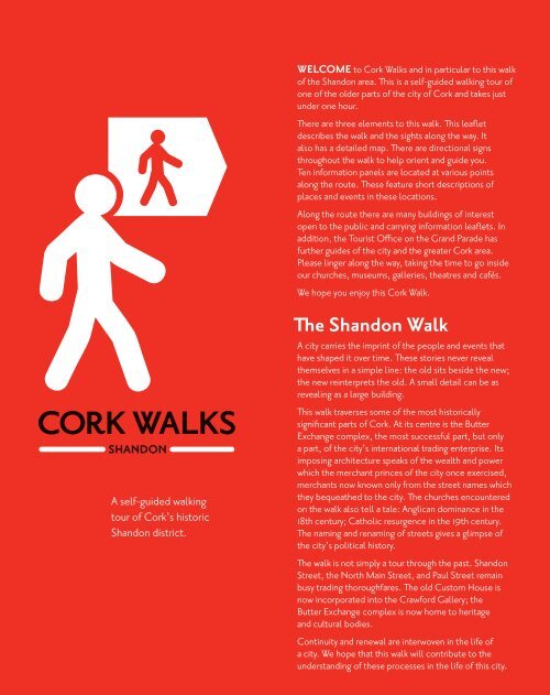
A self-guided walking<br />
tour of Cork’s historic<br />
<strong>Shandon</strong> district.<br />
Welcome to Cork <strong>Walk</strong>s and in particular to this walk<br />
of the <strong>Shandon</strong> area. This is a self-guided walking tour of<br />
one of the older parts of the city of Cork and takes just<br />
under one hour.<br />
<strong>The</strong>re are three elements to this walk. This leaflet<br />
describes the walk and the sights along the way. It<br />
also has a detailed map. <strong>The</strong>re are directional signs<br />
throughout the walk to help orient and guide you.<br />
Ten information panels are located at various points<br />
along the route. <strong>The</strong>se feature short descriptions of<br />
places and events in these locations.<br />
Along the route there are many buildings of interest<br />
open to the public and carrying information leaflets. In<br />
addition, the Tourist Office on the Grand Parade has<br />
further guides of the city and the greater Cork area.<br />
Please linger along the way, taking the time to go inside<br />
our churches, museums, galleries, theatres and cafés.<br />
We hope you enjoy this Cork <strong>Walk</strong>.<br />
<strong>The</strong> <strong>Shandon</strong> <strong>Walk</strong><br />
A city carries the imprint of the people and events that<br />
have shaped it over time. <strong>The</strong>se stories never reveal<br />
themselves in a simple line: the old sits beside the new;<br />
the new reinterprets the old. A small detail can be as<br />
revealing as a large building.<br />
This walk traverses some of the most historically<br />
significant parts of Cork. At its centre is the Butter<br />
Exchange complex, the most successful part, but only<br />
a part, of the city’s international trading enterprise. Its<br />
imposing architecture speaks of the wealth and power<br />
which the merchant princes of the city once exercised,<br />
merchants now known only from the street names which<br />
they bequeathed to the city. <strong>The</strong> churches encountered<br />
on the walk also tell a tale: Anglican dominance in the<br />
18th century; Catholic resurgence in the 19th century.<br />
<strong>The</strong> naming and renaming of streets gives a glimpse of<br />
the city’s political history.<br />
<strong>The</strong> walk is not simply a tour through the past. <strong>Shandon</strong><br />
Street, the North Main Street, and Paul Street remain<br />
busy trading thoroughfares. <strong>The</strong> old Custom House is<br />
now incorporated into the Crawford Gallery; the<br />
Butter Exchange complex is now home to heritage<br />
and cultural bodies.<br />
Continuity and renewal are interwoven in the life of<br />
a city. We hope that this walk will contribute to the<br />
understanding of these processes in the life of this city.
<strong>The</strong> <strong>Shandon</strong> <strong>Walk</strong><br />
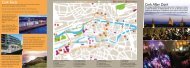
This walk begins on Daunt’s Square at Information Panel 1.<br />
Continue from here and walk along Paul Street.<br />
This is an early 18th century street. On the left is the 18th<br />
century St Paul’s Church. It was in St Paul’s graveyard that<br />
strangers to the city, often mariners, were buried. At the<br />
junction with St Paul’s Avenue is the former SS Peter & Paul<br />
School and Presbytery, built in 1879. Off Paul Street is the 1859<br />
Church of SS Peter and Paul, designed by Edward Pugin, son<br />
of the more famous Augustus. At this point, Paul Street passes<br />
through Rory Gallagher Place, named to commemorate the<br />
guitarist, who grew up in Cork. Carey’s Lane and French Church<br />
Street, run off to the right. This area was associated with Cork’s<br />
once thriving Huguenot community, whose graveyard is on<br />
French Church Street.<br />
Continue across the junction of Paul Street and Half Moon Street,<br />
onto Emmet Place.<br />
Half Moon Street was the childhood home of the writer, Seán<br />
Ó Faoláin. <strong>The</strong> Crawford Art Gallery, designed by Arthur Hill,<br />
was built in 1884 and incorporates the 1724 Customs House.<br />
Continue around the front of the Crawford Gallery to<br />
Information Panel 2 (Emmet Place). From there cross the road at<br />
the Christy Ring Bridge (do not cross the bridge) and proceed left<br />
along the river side of Lavitt’s Quay.<br />
Lavitt’s Quay was named after Joseph Lavitt, merchant and<br />
onetime mayor of the city. <strong>The</strong> view across the river is to the<br />
<strong>Shandon</strong> area. <strong>The</strong> area is a creation of Cork’s rapid commercial<br />
expansion into the food trade in the 18th century.<br />
No 16 Lavitt’s Quay, now encased in the modern development,<br />
is a late 18th century house. By the 1820s, this area was no<br />
longer a commercial docks but small trade continued into<br />
the mid 19th century, using the stairways to the river, to the<br />
annoyance of the city fathers who considered “the practice of<br />
buying potatoes out of boats ... a source of riot.”.<br />
Continue along the quay to Information Panel 3 (<strong>Shandon</strong><br />
Bridge). From there cross <strong>Shandon</strong> Bridge and turn right.<br />
Remain on the river side of the road.<br />
This river frontage is Pope’s Quay named after the Widow Pope<br />
who, in 1718 was “given liberty” to build a quay. In the 18th<br />
century, this area was the thriving docks of the city. <strong>The</strong> houses<br />
fronting the river are early 18th century.<br />
Continue along Pope’s Quay to view Information Panel 4<br />
(St Mary’s Church).<br />
Next continue around the wide corner onto John Redmond Street.<br />
John Redmond Street, formerly Mulgrave Street, was laid out<br />
in the late 1830s, to create access from the Butter Exchange<br />
1<br />
2<br />
3<br />
4<br />
5<br />
A B c D e F<br />
GLEN RYAN ROAD<br />
BLARNEY STREET<br />
NORTH MALL<br />
BACHELOR’S QUAY<br />
GRATTAN STREET REET<br />
WOLF TONE STREET<br />
BROGUEMAKER’S HILL<br />
Brown’s<br />
Square<br />
j<br />
ADELAIDE STREET<br />
FAIR STREET<br />
SHANDON STREET<br />
POPE’S QUAY<br />
Griffith Bridge<br />
NORTH MAIN STREET<br />
Vision centre<br />
@ St Peter’s<br />
CATHEDRAL ROAD<br />
1)<br />
i<br />
ST RITA’S PLACE<br />
KYRL’S QUAY<br />
SHANDON STREET<br />
finish<br />
LIBERTY STREET<br />
CHURCH STREET<br />
DOMINICK STREET<br />
NORTH MAIN STREET<br />
OLD FRIARY PLACE<br />
KYLE STREET<br />
GERALD GRIFFIN FFIN STREET STR<br />
JOHN PHILPOT CURRAN ST<br />
EASON’S AVENUE<br />
COAL QUAY<br />
CASTLE ST<br />
cathedral of<br />
St mary and St Anne<br />
(North Cathedral)<br />
CATHEDRAL ST<br />
CATHEDRAL AVE<br />
EXCHANGE ST<br />
POPE’S QUAY<br />
CORNMARKET STREET<br />
CHAPEL STREET<br />
f<br />
Firkin crane<br />
d<br />
h<br />
LITTLE<br />
MARKET STREET<br />
Presbytery<br />
g<br />
b<br />
WASHINGTON WASHINGTON STREET STRE EET<br />
EASON’S HILL<br />
St. Anne’s<br />
church<br />
JOHN REDMOND STREET<br />
MULGRAVE PL.<br />
ST. PAUL’S AVENUE<br />
GRAND PARADE ARADE<br />
e<br />
ROMAN STREET<br />
BOB & JOAN WALK<br />
Butter<br />
exchange Hotel<br />
WIDDERINGS LANE DOMINICK STREET<br />
<strong>Shandon</strong> Bridge<br />
Skiddy’s<br />
Almshouse<br />
St. mary’s<br />
church<br />
Presbytery<br />
St Paul’s<br />
church<br />
PAUL STREET<br />
Daunt’s<br />
Square<br />
start<br />
ROMAN WALK<br />
JOHN STREET UPPER<br />
Dominican<br />
Priory<br />
50 Pope’s<br />
Quay<br />
POPE’S QUAY<br />
RIVeR lee<br />
(North channel)<br />
JOHN REDMOND ST.<br />
LAVITT’S QUAY<br />
Rory<br />
Gallagher<br />
Place<br />
CAREY’S LANE<br />
ST. PATRICK’S STREET<br />
HALF MOON ST.<br />
ACADEMY STREET<br />
FRENCH CHURCH STREET<br />
KNAPP’S SQ.<br />
C<br />
EMMET PLACE<br />
Key:<br />
<strong>Walk</strong> route<br />
Information Panel<br />
Fingerpost guide<br />
DEVONSHIRE DEVONSHIRE ST. ST.<br />
CARROLL’S QUAY<br />
PINE STREET<br />
CAMDEN QUAY<br />
christy Ring Bridge<br />
ST. PATRICK’S STREETT<br />
COBURG ST.<br />
A B c D e F<br />
to the quays beyond St Patrick’s Bridge. It was renamed in the<br />
early part of the twentieth century to honour a leader of the<br />
Nationalist movement.<br />
Continue up the hill, passing Dominick Street on your left, and<br />
follow the curve of the street.<br />
Opposite is the former 1721 North Infirmary, now a hotel. A<br />
stone tablet listing the subscribers to the 1883 rebuilding is<br />
retained just inside the gates.<br />
Continue up John Redmond Street.<br />
SS Peter<br />
& Paul<br />
To Tourist Information office<br />
opera<br />
House<br />
crawford<br />
Gallery<br />
ST. ST. PATRICK’S PAT STREET<br />
BRIDGE STREET<br />
1<br />
2<br />
3<br />
St. Patrick’s rick’s Bridge Bri<br />
No 2 Rowland’s Lane was the home of Annie Moore, the<br />
first person to enter Ellis Island, New York. At the junction<br />
of John Redmond Street and Mulgrave Place is the Exchange<br />
Toffee Works. <strong>The</strong> Cork Shakespearian Company, the nursery<br />
of a generation of Cork actors guided by Father O’Flynn, is<br />
commemorated in stone above the side entrance to the toffee<br />
works. Opposite is the former home of the Butter Exchange<br />
Band, established in 1878.<br />
Continue to Information Panel 5 (<strong>The</strong> Firkin Crane).<br />
<strong>The</strong> Firkin Crane stands on the site of <strong>Shandon</strong> Castle<br />
4<br />
5<br />
described in 1690 as ‘a large round tower with 16 guns and a<br />
good entrenchment’. <strong>The</strong> terrace of houses to the left of the<br />
Firkin Crane have gable fronts, characteristic of early 18th<br />
century Cork.<br />
Continue to Information Panel 6 (St Anne’s Church, <strong>Shandon</strong>).<br />
On the right side of Bob & Joan’s <strong>Walk</strong> is the birthplace of<br />
Jack Lynch, distinguished sportsman and former Taoiseach<br />
(Prime Minister).<br />
To continue the walk return along Bob & Joan’s <strong>Walk</strong>, turn right<br />
and, with the front of St Anne’s Church on your right, continue<br />
straight up toward the North Cathedral; at the end of Chapel<br />
Street, cross the road to Information Panel 7 (Cathedral of St<br />
Mary and St Anne).<br />
To continue the walk proceed to the main crossroads and cross<br />
the road onto the left hand side of <strong>Shandon</strong> Street. <strong>Walk</strong> down<br />
<strong>Shandon</strong> Street.<br />
You are now walking down what was the spine of the city’s<br />
commercial life in the 18th century. Such was the scale of the<br />
beef trade that the area was known as the “slaughterhouse of<br />
Ireland”. Notice, on the right side of the street, the bow front<br />
of No 120, a characteristic of 18th and 19th Cork architecture<br />
and the gable fronts of No’s 118–119 and No’s 111–112.<br />
Continue on to Information Panel 8 (<strong>Shandon</strong> Street Area).<br />
Continue down <strong>Shandon</strong> Street.<br />
Beyond the Post Office, the car park of the modern Pope’s<br />
Quay apartment development was once the site of the 1693<br />
Anglican St Mary’s Church, which was demolished in 1879. It<br />
was described as ‘a neat parish church, with two windows in the<br />
east end’.<br />
Continue down <strong>Shandon</strong> Street to Information Panel 9 (Brown’s<br />
Square) and across Griffith Bridge (North Gate Bridge) to the<br />
North Main Street.<br />
<strong>Walk</strong>ing across Griffith Bridge you enter the medieval city. Up<br />
to the end of the 18th century the bridge at this location was<br />
the only connection between the city and its rich agricultural<br />
hinterland to the north. <strong>The</strong> street itself was once the northern<br />
part of the main street of the city. On the footpaths are plaques<br />
which mark the sites of the lanes which ran off the street.<br />
Continue to the junction of Adelaide Street and North<br />
Main Street.<br />
This is the site of Skiddy’s Castle, marked by a plaque. <strong>The</strong><br />
fireplace from the castle is now high in the wall of No 13, which<br />
is on the left side of the street.<br />
<strong>The</strong> next Information Panel 10 (North Main Street) is situated at<br />
the Vision Centre, formerly St. Peter’s Church.<br />
<strong>The</strong> walk ends here. To return to Information Panel 1 on Daunt’s<br />
Square, continue along the North Main Street, turn left onto<br />
Castle Street and then right to Daunt’s Square.
Index<br />
50 Pope’s Quay ............................. D3<br />
Academy Street .............................. E5<br />
Adelaide Street ...............................B4<br />
Bachelor’s Quay .............................A4<br />
Blarney Street .................................. A3<br />
Bob & Joan <strong>Walk</strong> ............................ D2<br />
Bridge Street .....................................F3<br />
Broguemaker’s hill ......................... B2<br />
Brown’s Square ............................... B3<br />
Camden Quay ................................ E3<br />
Carroll’s Quay ................................. E3<br />
Carey’s Lane .................................. D5<br />
Castle Street ...................................C5<br />
Cathedral Avenue ...........................C1<br />
Cathedral of St Mary and St Anne<br />
(North Cathedral) .................................C1<br />
Cathedral Road ............................... B1<br />
Cathedral Street .............................C1<br />
Chapel Street ..................................C1<br />
Christy Ring Bridge ........................E4<br />
Church of SS Peter and Paul ..... D5<br />
Church Street ................................ C2<br />
Coal Quay .......................................C3<br />
Coburg Street .................................F3<br />
Cork Butter Exchange ................. C2<br />
Cork Butter Museum ................... C2<br />
Cork Opera House ........................E4<br />
Cork Vision Centre ........................B4<br />
Cornmarket Street ........................ C4<br />
Crawford Municipal Art Gallery E4<br />
Daunt’s Square ............................. D5<br />
Devonshire Street ......................... E3<br />
Dominican Church of St Mary .. D3<br />
Dominican Priory .......................... D3<br />
Dominick Street ........................... C2<br />
Eason’s Avenue ............................. C2<br />
Eason’s Hill .......................................D1<br />
Emmet Place ...................................E4<br />
Exchange Street ............................ C2<br />
Fair Street .......................................... B1<br />
Firkin Crane ..................................... C2<br />
French Church Street .................. D5<br />
Gerald Griffin Street .....................C1<br />
Glen Ryan Road ..............................A2<br />
Graffiti <strong>The</strong>atre Company .......... C2<br />
Grand Parade .................................. D5<br />
Grattan Street .................................A4<br />
Griffith Bridge (North Gate Bridge) . B3<br />
Half Moon Street ...........................E4<br />
John Philpot Curran Street ...........C1<br />
John Redmond Street .................. D2<br />
John Street Upper ........................ D2<br />
Knapp’s Square ............................... E3<br />
Kyle Street ...................................... C4<br />
Kyrl’s Quay ...................................... B3<br />
Lavitt’s Quay................................... D4<br />
Liberty Street .................................. B5<br />
Little Market Street ..................... C4<br />
Mulgrave Place .............................. C2<br />
No 11 Emmet Place ........................E4<br />
North Cathedral Presbytery ........C1<br />
North Cathedral ..............................C1<br />
North Main Street ..........................B4<br />
North Mall ....................................... A3<br />
Old Friary Place ............................. C2<br />
Old Mallow Road .......................... E3<br />
Paul Street ...................................... D5<br />
Pine Street ........................................ E3<br />
Pope’s Quay .................................... B3<br />
Roman Street ...................................D1<br />
Roman <strong>Walk</strong> .................................... D3<br />
<strong>Shandon</strong> Bridge ...............................C3<br />
<strong>Shandon</strong> Craft Centre ................. C2<br />
<strong>Shandon</strong> Street ................................C1<br />
Skiddy’s Almshouse ...................... D2<br />
St Anne’s Church........................... C2<br />
St Patrick’s Bridge ......................... F4<br />
St Patrick’s Street ......................... D5<br />
St Paul’s Avenue ............................ D4<br />
St Paul’s Church ............................ D5<br />
St Peter’s Church ...........................B4<br />
St Rita’s Place ................................. B3<br />
Tourist Information Office ......... D5<br />
Widderling’s Lane ..........................C3<br />
Wolf Tone Street ............................. B1<br />
Information Panels<br />
No 1 ................................................... D5<br />
No 2 ..................................................E4<br />
No 3 ................................................... E3<br />
No 4 .................................................. C2<br />
No 5 ................................................... D2<br />
No 6 ...................................................C1<br />
No 7 ................................................... B2<br />
No 8 ................................................... B3<br />
No 9 ...................................................B4<br />
No 10 ................................................ C4<br />
This project demonstrates the<br />
Government’s support for cycling<br />
and walking as the most sustainable<br />
ways to travel.<br />
CW-S-EN-09-09<br />
COMHAIRLE CATHRACH CHORCAÍ<br />
CORK CITY COUNCIL<br />
www.corkcity.ie<br />
For more information please contact<br />
Cork City Council<br />
Traffic Division<br />
T: 021 492 4452<br />
email: traffic@corkcity.ie